
Point Hope, Alaska
Encyclopedia
Point Hope is a city in North Slope Borough, Alaska
, United States. At the 2000 census the population was 757.
landhead, at the NW end of the Lisburne Peninsula
, on the Chukchi Sea
coast, 40 mi. SW of Cape Lisburne, Arctic Slope at 68°20′49"N 166°45′47"W (68.347052, -166.762917).
According to the United States Census Bureau
, the city has a total area of 6.4 square miles (16.6 km²), of which, 6.3 square miles (16.3 km²) of it is land and 0.1 square mile (0.258998811 km²) of it (1.09%) is water.
, 0.13% Black
or African American
, 87.05% Native American
, 0.13% Asian
, 0.13% from other races
, and 3.83% from two or more races. 1.72% of the population were Hispanic
or Latino
of any race.
There were 186 households out of which 54.8% had children under the age of 18 living with them, 50.0% were married couples living together, 19.4% had a female householder with no husband present, and 18.3% were non-families. 13.4% of all households were made up of individuals and 2.2% had someone living alone who was 65 years of age or older. The average household size was 4.07 and the average family size was 4.50.
In the city the age distribution of the population shows 42.5% under the age of 18, 11.6% from 18 to 24, 26.0% from 25 to 44, 14.7% from 45 to 64, and 5.2% who were 65 years of age or older. The median age was 22 years. For every 100 females there were 122.6 males. For every 100 females age 18 and over, there were 118.6 males.
The median income for a household in the city was $63,125, and the median income for a family was $66,250. Males had a median income of $41,750 versus $35,625 for females. The per capita income
for the city was $16,641. About 13.9% of families and 14.8% of the population were below the poverty line, including 17.3% of those under age 18 and 16.2% of those age 65 or over.
 Before any modern settlement, the Ipiutak lived here.
The descriptive Inuit
name of the place, "Tikarakh" or "Tikigaq
" commonly spelled "Tiagara", means "forefinger". It was recorded as "Tiekagagmiut" in 1861 by P. Tikhmeniev Wich of the Russian Hydrographic Department
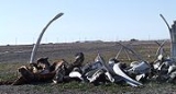
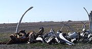
and on Russian Chart 1495 it became "Tiekaga". This ancient village site was advantageous, because the protrusion of Point Hope into the sea brought the whales close to the shore. At Tikigaq, they built semi-subterranean houses using mainly whalebone and driftwood. Point Hope is one of the oldest continually occupied sites in North America. While some of the earlier dwellings have been lost to erosion as the island shrinks, it still provides a welter of valuable information to archaeologists on how early Eskimos survived in their harsh environment. The Tikigaq site is "by far the most extensive and complete one-period site yet discovered and described in the entire circumpolar region." - Helge Larsen
The first recorded Europeans to sight this cape were Russian
explorers Mikhail Vasiliev
and Gleb Shishmaryov
of the Imperial Russian Navy
on the ships Otkrietie and Blagonamierennie. Vasiliev and Shishmaryov named this landhead Mys Golovnina, after Vice Admiral Vasily Golovnin
(1776–1831).
The cape at Point Hope was renamed by Captain Frederick William Beechey
of the Royal Navy
, who wrote on August 2, 1826: "I named it Point Hope in compliment to Sir William Johnstone Hope
". According to Archdeacon Stuck (1920, p. 96) Hope was from a "well-known house long connected with the sea".
Point Hope residents successfully opposed Operation Chariot (1958)
, which would have involved buried thermonuclear detonations some 30 miles from the village to create a deep-water artificial harbor, which would only have been usable about three months out of the year.
North Slope Borough, Alaska
-National protected areas:* Alaska Maritime National Wildlife Refuge ** Cape Lisburne** Cape Thompson* Arctic National Wildlife Refuge ** Mollie Beattie Wilderness * Gates of the Arctic National Park and Preserve...
, United States. At the 2000 census the population was 757.
Geography
Point Hope town is located in the Point HopePoint Hope (cape), Alaska
Point Hope is a landhead in the U.S. state of Alaska, located at the western tip of the Lisburne Peninsula. It lies on the Chukchi Sea coast, 40 miles southwest of Cape Lisburne, Arctic Slope at...
landhead, at the NW end of the Lisburne Peninsula
Lisburne Peninsula
The Lisburne Peninsula is a peninsula jutting out into the Chukchi Sea on the western coast of the U.S. state of Alaska. It is located at the westernmost point of the North Slope Borough. It is roughly trapezoid-shaped, having two points, the northwestern one being Cape Lisburne and the...
, on the Chukchi Sea
Chukchi Sea
Chukchi Sea is a marginal sea of the Arctic Ocean. It is bounded on the west by the De Long Strait, off Wrangel Island, and in the east by Point Barrow, Alaska, beyond which lies the Beaufort Sea. The Bering Strait forms its southernmost limit and connects it to the Bering Sea and the Pacific...
coast, 40 mi. SW of Cape Lisburne, Arctic Slope at 68°20′49"N 166°45′47"W (68.347052, -166.762917).
According to the United States Census Bureau
United States Census Bureau
The United States Census Bureau is the government agency that is responsible for the United States Census. It also gathers other national demographic and economic data...
, the city has a total area of 6.4 square miles (16.6 km²), of which, 6.3 square miles (16.3 km²) of it is land and 0.1 square mile (0.258998811 km²) of it (1.09%) is water.
Demographics
As of the census of 2000, there were 757 people, 186 households, and 151 families residing in the city. The population density was 119.4 people per square mile (46.1/km²). There were 215 housing units at an average density of 33.9 per square mile (13.1/km²). The racial makeup of the city was 8.72% WhiteRace (United States Census)
Race and ethnicity in the United States Census, as defined by the Federal Office of Management and Budget and the United States Census Bureau, are self-identification data items in which residents choose the race or races with which they most closely identify, and indicate whether or not they are...
, 0.13% Black
Race (United States Census)
Race and ethnicity in the United States Census, as defined by the Federal Office of Management and Budget and the United States Census Bureau, are self-identification data items in which residents choose the race or races with which they most closely identify, and indicate whether or not they are...
or African American
Race (United States Census)
Race and ethnicity in the United States Census, as defined by the Federal Office of Management and Budget and the United States Census Bureau, are self-identification data items in which residents choose the race or races with which they most closely identify, and indicate whether or not they are...
, 87.05% Native American
Race (United States Census)
Race and ethnicity in the United States Census, as defined by the Federal Office of Management and Budget and the United States Census Bureau, are self-identification data items in which residents choose the race or races with which they most closely identify, and indicate whether or not they are...
, 0.13% Asian
Race (United States Census)
Race and ethnicity in the United States Census, as defined by the Federal Office of Management and Budget and the United States Census Bureau, are self-identification data items in which residents choose the race or races with which they most closely identify, and indicate whether or not they are...
, 0.13% from other races
Race (United States Census)
Race and ethnicity in the United States Census, as defined by the Federal Office of Management and Budget and the United States Census Bureau, are self-identification data items in which residents choose the race or races with which they most closely identify, and indicate whether or not they are...
, and 3.83% from two or more races. 1.72% of the population were Hispanic
Race (United States Census)
Race and ethnicity in the United States Census, as defined by the Federal Office of Management and Budget and the United States Census Bureau, are self-identification data items in which residents choose the race or races with which they most closely identify, and indicate whether or not they are...
or Latino
Race (United States Census)
Race and ethnicity in the United States Census, as defined by the Federal Office of Management and Budget and the United States Census Bureau, are self-identification data items in which residents choose the race or races with which they most closely identify, and indicate whether or not they are...
of any race.
There were 186 households out of which 54.8% had children under the age of 18 living with them, 50.0% were married couples living together, 19.4% had a female householder with no husband present, and 18.3% were non-families. 13.4% of all households were made up of individuals and 2.2% had someone living alone who was 65 years of age or older. The average household size was 4.07 and the average family size was 4.50.
In the city the age distribution of the population shows 42.5% under the age of 18, 11.6% from 18 to 24, 26.0% from 25 to 44, 14.7% from 45 to 64, and 5.2% who were 65 years of age or older. The median age was 22 years. For every 100 females there were 122.6 males. For every 100 females age 18 and over, there were 118.6 males.
The median income for a household in the city was $63,125, and the median income for a family was $66,250. Males had a median income of $41,750 versus $35,625 for females. The per capita income
Per capita income
Per capita income or income per person is a measure of mean income within an economic aggregate, such as a country or city. It is calculated by taking a measure of all sources of income in the aggregate and dividing it by the total population...
for the city was $16,641. About 13.9% of families and 14.8% of the population were below the poverty line, including 17.3% of those under age 18 and 16.2% of those age 65 or over.
History
The descriptive Inuit
Inuit
The Inuit are a group of culturally similar indigenous peoples inhabiting the Arctic regions of Canada , Denmark , Russia and the United States . Inuit means “the people” in the Inuktitut language...
name of the place, "Tikarakh" or "Tikigaq
Tikigaq
The Tikiġaġmiut, an Inuit people, live two hundred miles north of the Arctic Circle, southwest of Barrow, Alaska, in an Inupiaq village of Point Hope, Alaska . The Tikigaq are the oldest continuously settled Native American site on the continent...
" commonly spelled "Tiagara", means "forefinger". It was recorded as "Tiekagagmiut" in 1861 by P. Tikhmeniev Wich of the Russian Hydrographic Department
Imperial Russian Navy
The Imperial Russian Navy refers to the Tsarist fleets prior to the February Revolution.-First Romanovs:Under Tsar Mikhail Feodorovich, construction of the first three-masted ship, actually built within Russia, was completed in 1636. It was built in Balakhna by Danish shipbuilders from Holstein...
and on Russian Chart 1495 it became "Tiekaga". This ancient village site was advantageous, because the protrusion of Point Hope into the sea brought the whales close to the shore. At Tikigaq, they built semi-subterranean houses using mainly whalebone and driftwood. Point Hope is one of the oldest continually occupied sites in North America. While some of the earlier dwellings have been lost to erosion as the island shrinks, it still provides a welter of valuable information to archaeologists on how early Eskimos survived in their harsh environment. The Tikigaq site is "by far the most extensive and complete one-period site yet discovered and described in the entire circumpolar region." - Helge Larsen
The first recorded Europeans to sight this cape were Russian
Russians
The Russian people are an East Slavic ethnic group native to Russia, speaking the Russian language and primarily living in Russia and neighboring countries....
explorers Mikhail Vasiliev
Ensign Mikhail Vasiliev
Mikhail Nikolayevich Vasilyev was a Russian explorer and vice admiral of the Imperial Russian Navy. He is reputed for having surveyed the then little-known coast of Alaska as navigator. Vasiliev was sent by the Russian Imperial Hydrographic Service in 1819 to explore the northern parts of the...
and Gleb Shishmaryov
Gleb Shishmaryov
Gleb Semyonovich Shishmaryov was a rear admiral of the Imperial Russian Navy. He is reputed for having surveyed the then little-known coast of Alaska as navigator...
of the Imperial Russian Navy
Imperial Russian Navy
The Imperial Russian Navy refers to the Tsarist fleets prior to the February Revolution.-First Romanovs:Under Tsar Mikhail Feodorovich, construction of the first three-masted ship, actually built within Russia, was completed in 1636. It was built in Balakhna by Danish shipbuilders from Holstein...
on the ships Otkrietie and Blagonamierennie. Vasiliev and Shishmaryov named this landhead Mys Golovnina, after Vice Admiral Vasily Golovnin
Vasily Golovnin
Vasily Mikhailovich Golovnin .-Early life and career:Vasily Mikhailovich Golovnin was born in April 1776, in the village of Gulyniki in Ryazan Oblast, on his father's country estate. Both his father and grandfather had served in the Russian military as officers in the elite Preobrazhensky...
(1776–1831).
The cape at Point Hope was renamed by Captain Frederick William Beechey
Frederick William Beechey
Frederick William Beechey was an English naval officer and geographer. He was the son of Sir William Beechey, RA., and was born in London.-Career:...
of the Royal Navy
Royal Navy
The Royal Navy is the naval warfare service branch of the British Armed Forces. Founded in the 16th century, it is the oldest service branch and is known as the Senior Service...
, who wrote on August 2, 1826: "I named it Point Hope in compliment to Sir William Johnstone Hope
William Johnstone Hope
Vice Admiral Sir William Johnstone Hope, GCB was a prominent and controversial British Royal Navy officer and politician in late eighteenth and early nineteenth century Britain, whose career experienced fleet actions, disputes with royalty, party politics and entry to both Russian and British...
". According to Archdeacon Stuck (1920, p. 96) Hope was from a "well-known house long connected with the sea".
Point Hope residents successfully opposed Operation Chariot (1958)
Operation Chariot (1958)
Project Chariot was a 1958 US Atomic Energy Commission proposal to construct an artificial harbor at Cape Thompson on the North Slope of the U.S...
, which would have involved buried thermonuclear detonations some 30 miles from the village to create a deep-water artificial harbor, which would only have been usable about three months out of the year.