

Peshev Ridge
Encyclopedia
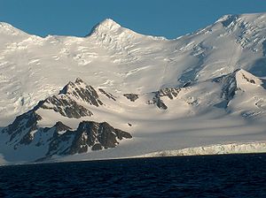
Tangra Mountains
Tangra Mountains form the principal mountain range of Livingston Island in the South Shetland Islands, Antarctica...
extending 2 km (1.2 mi) along the northeast coast of Brunow Bay
Brunow Bay
Brunow Bay is a 2.33 km wide bay indenting for 1.5 km the southeast side of Livingston Island in the South Shetland Islands, Antarctica. The bay is entered between Samuel Point and Vazov Point, and has its northwestern coast formed by the terminus of Macy Glacier.The feature is named by...
and southeast of Macy Glacier
Macy Glacier
Macy Glacier is a 6 km long and 2.3 km crescent-shaped glacier on the southern slopes of Tangra Mountains, Livingston Island in the South Shetland Islands, Antarctica...
, Livingston Island in the South Shetland Islands
South Shetland Islands
The South Shetland Islands are a group of Antarctic islands, lying about north of the Antarctic Peninsula, with a total area of . By the Antarctic Treaty of 1959, the Islands' sovereignty is neither recognized nor disputed by the signatories and they are free for use by any signatory for...
, Antarctica. Its east extremity is formed by the summit St. Naum Peak
St. Naum Peak
St. Naum Peak is a rocky peak of elevation 560 m in the east extremity of Peshev Ridge, Tangra Mountains, Livingston Island in the South Shetland Islands, Antarctica...
(620 m (2,034 ft)), separated from Balchik Ridge
Balchik Ridge
Balchik Ridge is a 1.3 km long narrow ridge in Tangra Mountains on Livingston Island in the South Shetland Islands, Antarctica with a highest point of 550m. The ridge adjoins the col linking Silistra Knoll and Peshev Ridge and surmounts Boyana Glacier to the southwest, south and east...
to the east by Starosel Gate
Starosel Gate
Starosel Gate is a 150-m wide pass of elevation 500 m situated between St. Naum Peak and the north extremity of Balchik Ridge in Levski Ridge, Tangra Mountains on Livingston Island, Antarctica. Providing overland access from Boyana Glacier to upper Macy Glacier. Bulgarian topographic survey...
. The ridge was named in honour of Dimitar Peshev
Dimitar Peshev
Dimitar Peshev was the Deputy Speaker of the National Assembly of Bulgaria and Minister of Justice during World War II...
(1894–1973), who led the nationwide campaign that kept Bulgaria
Bulgaria
Bulgaria , officially the Republic of Bulgaria , is a parliamentary democracy within a unitary constitutional republic in Southeast Europe. The country borders Romania to the north, Serbia and Macedonia to the west, Greece and Turkey to the south, as well as the Black Sea to the east...
’s Jews
Jews
The Jews , also known as the Jewish people, are a nation and ethnoreligious group originating in the Israelites or Hebrews of the Ancient Near East. The Jewish ethnicity, nationality, and religion are strongly interrelated, as Judaism is the traditional faith of the Jewish nation...
safe during the Holocaust.
Location
The central peak, named Peshev Peak in association, is located at 62°41′57.8"S 60°07′31"W which is 4.91 km (3.1 mi) southwest of Great Needle PeakGreat Needle Peak
Great Needle Peak is the summit of the central Levski Ridge in Tangra Mountains on Livingston Island, Antarctica. Rising to ca. 1690 m, it is the second highest peak of Tangra Mountains after Mount Friesland...
(Falsa Aguja), 4.1 km (2.5 mi) south of Lyaskovets Peak
Lyaskovets Peak
Lyaskovets Peak is the easternmost peak of Friesland Ridge in the Tangra Mountains, eastern Livingston Island and has an elevation 1,473 m...
, 4.28 km (2.7 mi) east by south of Simeon Peak
Simeon Peak
Simeon Peak rises to 1,576 m in Friesland Ridge, Tangra Mountains, Livingston Island in the South Shetland Islands, Antarctica. The peak is linked to St...
and 3.68 km (2.3 mi) northeast of Needle Peak (Bulgarian topographic survey Tangra 2004/05
Tangra 2004/05
The Tangra 2004/05 Expedition was commissioned by the Antarctic Place-names Commission at the Ministry of Foreign Affairs of Bulgaria, managed by the Manfred Wörner Foundation, and supported by the Bulgarian Antarctic Institute, the Institute of Mathematics and Informatics at the Bulgarian Academy...
, and mapping in 2005 and 2009).
Maps
- L.L. Ivanov et al. Antarctica: Livingston Island and Greenwich Island, South Shetland Islands. Scale 1:100000 topographic map. Sofia: Antarctic Place-names Commission of Bulgaria, 2005.
- L.L. Ivanov. Antarctica: Livingston Island and Greenwich, Robert, Snow and Smith Islands. Scale 1:120000 topographic map. Troyan: Manfred Wörner Foundation, 2009. ISBN 978-954-92032-6-4