
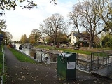
Penton Hook Lock
Encyclopedia
Penton Hook Lock is a lock
on the River Thames
in England situated on the northern "Middlesex" bank near Laleham
, Surrey
.
The lock cuts across a large loop or hook in the river, creating Penton Hook Island
There is a large marina (Penton Hook Marina
) in the disused gravel pits connected to this loop. At over 266 ft (81.28 metres) it is the third longest lock on the river.
There are two weirs
, which were built some time after the lock. One weir links across to Penton Hook Island, and the other from the island across the old course of the river. The former weir has a wide footpath to the island, but the footpath across the other weir is closed.
The lock was completed in 1815, two years after Chertsey Lock, to become the lock farthest upstream on the Thames which was controlled by the City of London
. This is why the City's arms appear on the Lock Cottage built in 1814. The first weir was not built until 1846, positioned below the outfall of the Abbey River
for the benefit of the miller. This caused problems of too strong a stream and it was relocated above the outfall. The lock was rebuilt in 1909.
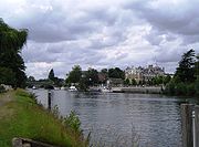 The river is built up on both sides after the lock and passes through Staines
. Between Staines Railway Bridge
and Staines Bridge
there is an open riverside area with pubs on both sides and the River Colne
joins the Thames here. After the bridge on the northern side is a replica of the London Stone
placed near here in 1285 to mark the upper limit of the tidal Thames and the jurisdiction of the City of London. Beside it is Church Island
and a recreation area and beyond it Hollyhock Island
and the wooded Holm Island
. The Surrey side was formerly an industrial area with the gas works and water works, but this is being redeveloped into business parks. The M25 Runnymede Bridge
crosses the river carrying the M25 motorway
and the old A30 road
just short of Bell Weir lock. There is a rowing club and Staines Regatta takes place on this stretch in July.
continues on the Middlesex bank as far as Staines Bridge, where it crosses over to the Surrey side until the lock.
Lock (water transport)
A lock is a device for raising and lowering boats between stretches of water of different levels on river and canal waterways. The distinguishing feature of a lock is a fixed chamber in which the water level can be varied; whereas in a caisson lock, a boat lift, or on a canal inclined plane, it is...
on the River Thames
River Thames
The River Thames flows through southern England. It is the longest river entirely in England and the second longest in the United Kingdom. While it is best known because its lower reaches flow through central London, the river flows alongside several other towns and cities, including Oxford,...
in England situated on the northern "Middlesex" bank near Laleham
Laleham
Laleham is a village in the borough of Spelthorne, in the county of Surrey in South East England and adjoins Staines. It is within the historic boundaries of Middlesex. To its south is Laleham Park by the River Thames, across green belt farmland to its north and south east are Ashford and...
, Surrey
Surrey
Surrey is a county in the South East of England and is one of the Home Counties. The county borders Greater London, Kent, East Sussex, West Sussex, Hampshire and Berkshire. The historic county town is Guildford. Surrey County Council sits at Kingston upon Thames, although this has been part of...
.
The lock cuts across a large loop or hook in the river, creating Penton Hook Island
Penton Hook Island
Penton Hook Island is an island in the River Thames in England adjacent to Penton Hook Lock, near Laleham, Surrey. At this point the natural course of the river makes a large loop or "hook" round the island, although this is now closed off by the weir...
There is a large marina (Penton Hook Marina
Penton Hook Marina
Penton Hook Marina is the largest inland marina in Britain. It it situated on the River Thames in Surrey between Staines and Chertsey on the western bank of the river and is close to Thorpe Park. It is on the reach above Chertsey Lock and opposite Penton Hook Island.The marina is set in 80 acres...
) in the disused gravel pits connected to this loop. At over 266 ft (81.28 metres) it is the third longest lock on the river.
There are two weirs
Weir
A weir is a small overflow dam used to alter the flow characteristics of a river or stream. In most cases weirs take the form of a barrier across the river that causes water to pool behind the structure , but allows water to flow over the top...
, which were built some time after the lock. One weir links across to Penton Hook Island, and the other from the island across the old course of the river. The former weir has a wide footpath to the island, but the footpath across the other weir is closed.
History
There was a history of problems to navigation caused by floodwaters bursting across the neck of the island. A lock was suggested here in 1809, and an enabling act passed in 1814.The lock was completed in 1815, two years after Chertsey Lock, to become the lock farthest upstream on the Thames which was controlled by the City of London
City of London
The City of London is a small area within Greater London, England. It is the historic core of London around which the modern conurbation grew and has held city status since time immemorial. The City’s boundaries have remained almost unchanged since the Middle Ages, and it is now only a tiny part of...
. This is why the City's arms appear on the Lock Cottage built in 1814. The first weir was not built until 1846, positioned below the outfall of the Abbey River
Abbey River
The Abbey River is a backwater of the River Thames in England, near Chertsey, Surrey. It runs from behind Penton Hook Island to below Chertsey Lock....
for the benefit of the miller. This caused problems of too strong a stream and it was relocated above the outfall. The lock was rebuilt in 1909.
Access to the lock
The lock is accessible on foot along the towpath from Staines Road coming out of Laleham or from the bottom of Penton Hook Road in Staines.Reach above the lock
Staines
Staines is a Thames-side town in the Spelthorne borough of Surrey and Greater London Urban Area, as well as the London Commuter Belt of South East England. It is a suburban development within the western bounds of the M25 motorway and located 17 miles west south-west of Charing Cross in...
. Between Staines Railway Bridge
Staines Railway Bridge
Staines Railway Bridge crosses the River Thames in England in a northeast to southwest direction at Staines, Surrey. It crosses the Thames on the reach between Penton Hook Lock and Bell Weir Lock....
and Staines Bridge
Staines Bridge
Staines Bridge is a road bridge running in a south-west to north-east direction across the River Thames in Surrey. It is on the modern A308 road and links the boroughs of Spelthorne and Runnymede at Staines and Egham Hythe....
there is an open riverside area with pubs on both sides and the River Colne
River Colne, Hertfordshire
The Colne is a river in England which is a tributary of the River Thames. It flows mainly through Hertfordshire and forms the boundary between the South Bucks district of Buckinghamshire and the London Borough of Hillingdon...
joins the Thames here. After the bridge on the northern side is a replica of the London Stone
London Stone (riparian)
London Stone is the name given to a number of boundary stones which stand beside rivers in south east England.-History:Until 1350, the English Crown held the right to fish the rivers of England and charged duties on those people it licenced to fish...
placed near here in 1285 to mark the upper limit of the tidal Thames and the jurisdiction of the City of London. Beside it is Church Island
Church Island
Church Island is a small island in the Menai Strait on the shores of Anglesey to which it is attached by a short causeway that is reachable only on foot off the Belgian Promenade. The whole of the island is taken up with St Tysilio's church, constructed in the 15th century, and the churchyard. ...
and a recreation area and beyond it Hollyhock Island
Hollyhock Island
Hollyhock Island is an island in the River Thames in England on the reach above Penton Hook Lock, near Staines, Surrey. The island is on the Buckinghamshire bank upstream of Staines Bridge and just downstream of the M25 Runnymede Bridge, and is paired with Holm Island.-References:...
and the wooded Holm Island
Holm Island
Holm Island is an island in the River Thames in England on the reach above Penton Hook Lock, near Staines. It is on the Buckinghamshire bank, just upstream of Hollyhock Island....
. The Surrey side was formerly an industrial area with the gas works and water works, but this is being redeveloped into business parks. The M25 Runnymede Bridge
M25 Runnymede Bridge
The M25 Runnymede Bridge is a motorway bridge built in the 1980s, carrying the M25 motorway across the River Thames. It carries the M25 North/South just south of Heathrow Airport and crosses the Thames on the reach above Penton Hook Lock and shortly before Bell Weir Lock.The bridge was built to...
crosses the river carrying the M25 motorway
M25 motorway
The M25 motorway, or London Orbital, is a orbital motorway that almost encircles Greater London, England, in the United Kingdom. The motorway was first mooted early in the 20th century. A few sections, based on the now abandoned London Ringways plan, were constructed in the early 1970s and it ...
and the old A30 road
A30 road
The 284 miles A30 road from London to Land's End, historically known as the Great South West Road used to provide the most direct route from London to the south west; more recently the M3 motorway and A303 road performs this function for much of the route and only parts of A30 now retain trunk...
just short of Bell Weir lock. There is a rowing club and Staines Regatta takes place on this stretch in July.
Thames Path
The Thames PathThames Path
The Thames Path is a National Trail, opened in 1996, following the length of the River Thames from its source near Kemble in Gloucestershire to the Thames Barrier at Charlton. It is about long....
continues on the Middlesex bank as far as Staines Bridge, where it crosses over to the Surrey side until the lock.
External links
- Penton Hook Lock at the River Thames Guide