
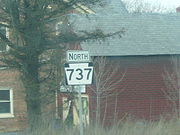
Pennsylvania Route 737
Encyclopedia
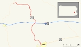
Pennsylvania Route 737 is a state highway in Berks County
, Pennsylvania
. The route runs from U.S. Route 222 in Kutztown
north to Pennsylvania Route 143
in Albany Township
. Route 737 heads north from an interchange with the U.S. Route 222 Kutztown Bypass north of Kutztown on Krumsville Road. It continues north through a small part of Maxatawny Township
into Greenwich Township
. The road features an interchange with Interstate 78
/U.S. Route 22
near the village of Krumsville
. Route 737 then heads northwest into Albany Township where it ends Route 143 near the village of Kempton
.
Route 737 was assigned to a formerly un-designated local road between Kutztown and Kempton in 1962. Around that time, U.S. Route 222 served as the southern terminus in downtown Kutztown. When the Kutztown Bypass was constructed in the 1970s, U.S. Route 222 was realigned off of Main Street in Kutztown and onto the bypass. The road, at that point, ended at the now locally-maintained Main Street until 1978, when the designation was truncated. Since then, the route has remained virtually untouched in alignment.
 Route 737 begins at the southern point of the interchange with U.S. Route 222 north of the municipality of Kutztown
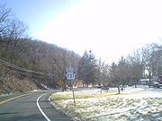
. South of the interchange, the right-of-way continues as Greenwich Street into downtown Kutztown. From the interchange, Route 737 heads northward along the community borderline on Krumsville Road. The route heads northward through dense forestry and some small hills, quickly entering the community of Eagle Point. In Eagle Point, the road becomes slightly developed. After the highway intersects with Sweet Corn Drive, Route 737 leaves the community and begins its way to the northwest.
Route 737 heads to the northwest, intersecting with Long Dam Road, which parallels through another set of deep forests. At a curve to the north, the highway intersects with Kutz Mill Road, the highway heads through a close area of fields and forests. At an intersection with Ebling Road, it begins curving its way through the area. After Wiltrout Road, the highway begins on a northward progression through Greenwich Township. After Sunrise Boulevard, Route 737 heads out of the developed area. Nearing an intersection with Sutter Road, Route 737 turns to the northeast and enters Krumsville
.
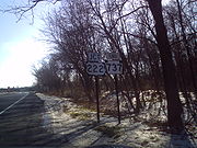
 In Krumsville, the surroundings of the highway becomes more developed, passing local commercial businesses. There it interchanges with Interstate 78
and U.S. Route 22
at Exit 40. After the interchange, the highway heads northward into the rural regions of Krumsville, intersecting with the former alignment of U.S. Route 22. At the intersection with Long Lane Road, Route 737 leaves Krumsville. There, the road becomes surrounded by fields, with several farmhouses in the area. After an intersection with Snyder Road, Route 737 begins to follow several bends in the highway, progressing its way towards Kempton
. Eventually there is a curve to the northwest, and the highway enters the developed community of Stony Run. The highway enters and leaves, turning now in a westerly progression. Forests and fields surround the progressing highway from north and the south, as Route 737 makes its final turn and into Kempton, another developed area. After passing Albany Township Elementary School, the designation terminates at an intersection with Route 143
south of Trexler.
 Route 737 originated as an unnumbered arterial highway from U.S. Route 222 in downtown Kutztown to Pennsylvania Route 143 at an intersection in Kempton. The state took over the alignment in 1962, designating the highway as Route 737 on the alignment of the arterial highway. In 1971, the newly-formed Pennsylvania Department of Transportation
began construction on the Kutztown Bypass, an alignment of U.S. Route 222 that was planned to bypass downtown Kutztown. The bypass was constructed in September 1972 and U.S. Route 222 was realigned onto the new highway in 1973. After the realignment, PA Route 737 now ended at unnumbered Main Street in downtown Kutztown for a short time. By 1978, the southern terminus of PA 737 had been adjusted to the interchange with the Kutztown Bypass. The route has remained virtually untouched since. Route 737 and its interchange with Interstate 78 in Krumsville was reconstructed in 2006, with the interchange receiving additional truck lanes from I-78. On July 23, 2009, the borough of Kutztown sold 5 acres (66,385.5 ft) of land to Maxatawny Township, Pennsylvania
for future construction of a sewer plant. In 2009, Berks County began to work on design for a new "Accelerated Bridge Program" for several bridges, one on Route 737 and two on nearby Quadrant Routes. The bridges are set to use stimulus money from the American Recovery and Reinvestment Act (ARRA), which will cost the county about $180,000 (2009 USD) for the studies.
Berks County, Pennsylvania
-Demographics:As of the census of 2000, there were 373,638 people, 141,570 households, and 98,532 families residing in the county. The population density was 435 people per square mile . There were 150,222 housing units at an average density of 175 per square mile...
, Pennsylvania
Pennsylvania
The Commonwealth of Pennsylvania is a U.S. state that is located in the Northeastern and Mid-Atlantic regions of the United States. The state borders Delaware and Maryland to the south, West Virginia to the southwest, Ohio to the west, New York and Ontario, Canada, to the north, and New Jersey to...
. The route runs from U.S. Route 222 in Kutztown
Kutztown, Pennsylvania
Kutztown is a borough in Berks County, Pennsylvania, southwest of Allentown and northeast of Reading. As of the 2000 census, the borough has a total population of 5,067. It is the site of Kutztown University.- History :...
north to Pennsylvania Route 143
Pennsylvania Route 143
Pennsylvania Route 143 is a long state highway in Pennsylvania. It runs from Pennsylvania Route 309 near New Tripoli to Pennsylvania Route 662 in Richmond Township just east of the town of Shoemakersville....
in Albany Township
Albany Township, Berks County, Pennsylvania
Albany Township is a township in Berks County, Pennsylvania, United States. The population was 1,662 at the 2000 census. A 2005 census estimate put the township's population at 1,712. The township hall is located in Kempton.-Geography:...
. Route 737 heads north from an interchange with the U.S. Route 222 Kutztown Bypass north of Kutztown on Krumsville Road. It continues north through a small part of Maxatawny Township
Maxatawny Township, Pennsylvania
Maxatawny Township is a township in Berks County, Pennsylvania, United States. The population was 5,982 at the 2000 census.-Geography:According to the United States Census Bureau, the township has a total area of 26.3 square miles . 26.2 square miles of it is land and 0.04 square...
into Greenwich Township
Greenwich Township, Pennsylvania
Greenwich Township is a township in Berks County, Pennsylvania, United States. The population was 3,386 at the 2000 census.-Geography:According to the United States Census Bureau, the township has a total area of , all of it land. It is drained by the Maiden Creek into the Schuylkill River...
. The road features an interchange with Interstate 78
Interstate 78
Interstate 78 is an Interstate Highway in the Northeast United States, running 144 miles from Interstate 81 northeast of Harrisburg, Pennsylvania, through Allentown, Pennsylvania, and western and northern New Jersey to the Holland Tunnel and Lower Manhattan in New York City.I-78 is a major road...
/U.S. Route 22
U.S. Route 22
U.S. Route 22 is a west–east route and is one of the original United States highways of 1926, running from Cincinnati, Ohio, at US 27, US 42, US 127, and US 52 to Newark, New Jersey, at U.S. Route 1/9 near the Newark Liberty International Airport.US 22 also carries the names of the William...
near the village of Krumsville
Krumsville, Pennsylvania
Krumsville is an unincorporated community in Berks County, Pennsylvania. It is located at the intersection of Pennsylvania Route 737 and Old U.S. Route 22. Important buildings in the area include the Greenwich-Lenhartsville Elementary School, Krumsville Hotel, and Mt. Zion's Church .Less than half...
. Route 737 then heads northwest into Albany Township where it ends Route 143 near the village of Kempton
Kempton, Pennsylvania
Kempton is an unincorporated community in eastern Albany Township, Berks County, Pennsylvania, United States with a zip code of 19529. Kempton is located at 40.626N, 75.852W, at the junction of Route 737 and Kistler Valley Road....
.
Route 737 was assigned to a formerly un-designated local road between Kutztown and Kempton in 1962. Around that time, U.S. Route 222 served as the southern terminus in downtown Kutztown. When the Kutztown Bypass was constructed in the 1970s, U.S. Route 222 was realigned off of Main Street in Kutztown and onto the bypass. The road, at that point, ended at the now locally-maintained Main Street until 1978, when the designation was truncated. Since then, the route has remained virtually untouched in alignment.
Route description
Kutztown, Pennsylvania
Kutztown is a borough in Berks County, Pennsylvania, southwest of Allentown and northeast of Reading. As of the 2000 census, the borough has a total population of 5,067. It is the site of Kutztown University.- History :...
. South of the interchange, the right-of-way continues as Greenwich Street into downtown Kutztown. From the interchange, Route 737 heads northward along the community borderline on Krumsville Road. The route heads northward through dense forestry and some small hills, quickly entering the community of Eagle Point. In Eagle Point, the road becomes slightly developed. After the highway intersects with Sweet Corn Drive, Route 737 leaves the community and begins its way to the northwest.
Route 737 heads to the northwest, intersecting with Long Dam Road, which parallels through another set of deep forests. At a curve to the north, the highway intersects with Kutz Mill Road, the highway heads through a close area of fields and forests. At an intersection with Ebling Road, it begins curving its way through the area. After Wiltrout Road, the highway begins on a northward progression through Greenwich Township. After Sunrise Boulevard, Route 737 heads out of the developed area. Nearing an intersection with Sutter Road, Route 737 turns to the northeast and enters Krumsville
Krumsville, Pennsylvania
Krumsville is an unincorporated community in Berks County, Pennsylvania. It is located at the intersection of Pennsylvania Route 737 and Old U.S. Route 22. Important buildings in the area include the Greenwich-Lenhartsville Elementary School, Krumsville Hotel, and Mt. Zion's Church .Less than half...
.
Interstate 78
Interstate 78 is an Interstate Highway in the Northeast United States, running 144 miles from Interstate 81 northeast of Harrisburg, Pennsylvania, through Allentown, Pennsylvania, and western and northern New Jersey to the Holland Tunnel and Lower Manhattan in New York City.I-78 is a major road...
and U.S. Route 22
U.S. Route 22
U.S. Route 22 is a west–east route and is one of the original United States highways of 1926, running from Cincinnati, Ohio, at US 27, US 42, US 127, and US 52 to Newark, New Jersey, at U.S. Route 1/9 near the Newark Liberty International Airport.US 22 also carries the names of the William...
at Exit 40. After the interchange, the highway heads northward into the rural regions of Krumsville, intersecting with the former alignment of U.S. Route 22. At the intersection with Long Lane Road, Route 737 leaves Krumsville. There, the road becomes surrounded by fields, with several farmhouses in the area. After an intersection with Snyder Road, Route 737 begins to follow several bends in the highway, progressing its way towards Kempton
Kempton, Pennsylvania
Kempton is an unincorporated community in eastern Albany Township, Berks County, Pennsylvania, United States with a zip code of 19529. Kempton is located at 40.626N, 75.852W, at the junction of Route 737 and Kistler Valley Road....
. Eventually there is a curve to the northwest, and the highway enters the developed community of Stony Run. The highway enters and leaves, turning now in a westerly progression. Forests and fields surround the progressing highway from north and the south, as Route 737 makes its final turn and into Kempton, another developed area. After passing Albany Township Elementary School, the designation terminates at an intersection with Route 143
Pennsylvania Route 143
Pennsylvania Route 143 is a long state highway in Pennsylvania. It runs from Pennsylvania Route 309 near New Tripoli to Pennsylvania Route 662 in Richmond Township just east of the town of Shoemakersville....
south of Trexler.
History
Pennsylvania Department of Transportation
The Pennsylvania Department of Transportation oversees transportation issues in the Commonwealth of Pennsylvania. The administrator of PennDOT is the Pennsylvania Secretary of Transportation, currently Barry Schoch Presently, PennDOT supports over of state roads and highways, about 25,000...
began construction on the Kutztown Bypass, an alignment of U.S. Route 222 that was planned to bypass downtown Kutztown. The bypass was constructed in September 1972 and U.S. Route 222 was realigned onto the new highway in 1973. After the realignment, PA Route 737 now ended at unnumbered Main Street in downtown Kutztown for a short time. By 1978, the southern terminus of PA 737 had been adjusted to the interchange with the Kutztown Bypass. The route has remained virtually untouched since. Route 737 and its interchange with Interstate 78 in Krumsville was reconstructed in 2006, with the interchange receiving additional truck lanes from I-78. On July 23, 2009, the borough of Kutztown sold 5 acres (66,385.5 ft) of land to Maxatawny Township, Pennsylvania
Maxatawny Township, Pennsylvania
Maxatawny Township is a township in Berks County, Pennsylvania, United States. The population was 5,982 at the 2000 census.-Geography:According to the United States Census Bureau, the township has a total area of 26.3 square miles . 26.2 square miles of it is land and 0.04 square...
for future construction of a sewer plant. In 2009, Berks County began to work on design for a new "Accelerated Bridge Program" for several bridges, one on Route 737 and two on nearby Quadrant Routes. The bridges are set to use stimulus money from the American Recovery and Reinvestment Act (ARRA), which will cost the county about $180,000 (2009 USD) for the studies.
Major intersections
See also
- List of State Routes in Pennsylvania
- Pennsylvania Route 863Pennsylvania Route 863Pennsylvania Route 863 is a state highway in Lehigh County, Pennsylvania. The route runs from U.S. Route 222 in Upper Macungie Township north to Pennsylvania Route 143 in Lynn Township.-Route description:...
- a highway that follows a similar alignment to PA 737 to the east.