
Pennsylvania Route 646
Encyclopedia
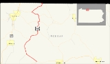
Pennsylvania Route 646 is a 19.09 miles (30.7 km) long state highway
located in McKean
county in Pennsylvania
. The southern terminus is at PA 59
in Keating Township
. The northern terminus is the New York
state line in Foster Township.
The route continues as New York State Route 16
in Cattaugarus County.
Route 646 was assigned in the 1928 mass numbering of state routes in Pennsylvania
. At that time, it consisted entirely of the PA 346–state line stretch in Foster Township. The rest of the stretch consisted of Route 59, now realigned, and Route 746, now decommissioned. Route 746 was decommissioned in 1946, and PA 59 was realigned in 1952, with PA 646 being extended onto its current alignment. The route has remained virtually unchanged since the change in 1952.
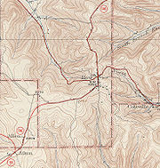
in the small borough of Ormsby. The highway, situated around several oil wells, progresses to the northwest through a moderately populated region of residential homes. Route 646 continues on this progression for several miles, parallelling a pipeline running through the Kinzua Valley. After an intersection with a local dirt road, the highway leaves Ormsby and continues into the under-populated forests in Keating Township
. The route follows an old railroad grade, entering the small unincorporated place of McKean
. When Route 646 turns to the north at a gradual bend, it crosses a second pipeline and enters the community of Cyclone
.
Upon entering Cyclone, Route 646 intersects with Pithole Road, which heads to the northeast and into McQuen Hollow, a local mountain range. The route itself heads to the northwest still, passing several residential homes in the area. After an intersection with Boyland Road, the highway turns to the north and leaves Cyclone for the woodlands in Keating Township once again. After leaving Cyclone, Route 646 enters the Bradford Oil Field, which includes the community of Cyclone and runs about two miles east of the Laffayette Township line. The route continues northbound for a couple miles, entering the community of Gifford
, situated near the Laffayette Township line. The community is moderately developed, with most of the region contained by residential homes and local dirt roads. The major intersection in Gifford along Route 646 is the one with Alley Gifford and Droney Road. At a fork in the highway with Fairground Road, the highway turns northeastward, looping around on a gradual bend of the Bradford Oil Field.
A short distance after the bend, Route 646 cotninues to the northeast, entering the community of Aiken, where at another fork in the road, Pennsylvania Route 770
begins. Route 646 continues to the northeast through Aiken, an under-developed community of residential homes. A short distance later, the highway crosses the township line into Bradford Township
. The route continues for several miles, making a gradual bend in the woodlands into Foster Township
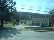
. Route 646 continues, making an intersection with Wolf Run Road, which heads southward to the community of Middletown. At that intersection, Route 646 turns northeastward, entering the community of Rew. In Rew, the route becomes moderately developed once again, where it intersects with Pennsylvania Route 46
. After intersecting with Rew–Bradford Road, a highway that becomes a dirt road up Pratt Hollow, Route 646 progresses to the north and exits Rew.
. The route intersects with a Schimp Lane, a local road, before turning to the north and out of Summit. The route heads northward for a short distance, paralleling a grade right-of-way road, which heads eastward to Walkertown. A short distance later, Route 646 enters a small developed area, where the route intersects with Pennsylvania Route 346
.
 At the intersection with Route 346, Route 646 turns off its right-of-way, which continues along a pipeline as a dirt road, and onto a concurrency with the aforementioned touring route. Route 646 and Route 346 head eastward, intersecting with several dirt roads in a light woodland. The two highways continue eastward, entering the community of Red Rock. In Red Rock, most of the highway is unpopulated, until an intersection with Narrow Gauge Road, where most of the residential homes stand. When Narrow Gauge Road intersects with the two highways once again, Routes 646 and 346 enter the community of Derrick City. In Derrick City, the highways pass along a stretch of residential houses before Route 646 turns off to the north on Olean Road. Route 346 continues ahead along Derrick Road towards Bradford
.
After turning on Olean Road, Route 646 turns to the northeast, running along the Pennbrook Run for the entire stretch of highway. Along the highway several residential homes surround, while the road enters the community of Bells Camp. Bells Camp is moderately developed, and is the last designated community along Route 646. The highway forks off from Bells Camp Road, continuing further to the northeast along Olean Road. When the route turns to the east, Route 646 intersects with a connector street back to Bells Camp Road, which parallels to the north. The highway is undeveloped from this point, intersecting with Fullerton Road, which terminates at Olean Road. The route continues northward, paralleling Pennsylvania Route 546
and Knapp Creek, before crossing the state line into New York
a distance northwest of Fullerton
. The right-of-way continues northward as New York State Route 16
towards Olean
.
 When the mass amount of state legislative routes were assigned in Pennsylvania
in 1928, SR 646 consisted of only the stretch from SR 346 in Derrick City to the New York state line. There was no concurrency with SR 346 at that time. The stretch from SR 59 to SR 346 was not state-maintained. The rest of the current SR 646 was an alignment of SR 59. The entire alignment of SR 646 was paved in 1930. Also that year, the stretch from SR 59 in Aiken to SR 46 in Rew was designated as Pennsylvania Route 746, a spur off SR 46.
This set of highways remained intact for over a decade, until 1946, when SR 746 was decommissioned in favor of extending SR 646 over its alignment. Now SR 646 continued along a concurrency with SR 346 and east of Red Rock, it went southward (away from SR 346) down to SR 59 in Aiken, where it ended. In 1952, SR 59 was realigned off its Ormbsy–Aiken alignment, and SR 646 was extended to Ormsby, where it ended at SR 59.
The final bridge along State Route 646 was constructed 1 miles (1.6 km) north of Gilmore over Pennbrook Run. Like the first bridge, it is a tee beam construction with a length of 32.15 feet (9.8 m). Like the previous two bridges, this one is also structurally deficient in its structure, having not been replaced since construction in 1930. To replace the bridge, it would cost $408,000.
State highway
State highway, state road or state route can refer to one of three related concepts, two of them related to a state or provincial government in a country that is divided into states or provinces :#A...
located in McKean
McKean County, Pennsylvania
As of the census of 2000, there were 45,936 people, 18,024 households, and 12,094 families residing in the county. The population density was 47 people per square mile . There were 21,644 housing units at an average density of 22 per square mile...
county in Pennsylvania
Pennsylvania
The Commonwealth of Pennsylvania is a U.S. state that is located in the Northeastern and Mid-Atlantic regions of the United States. The state borders Delaware and Maryland to the south, West Virginia to the southwest, Ohio to the west, New York and Ontario, Canada, to the north, and New Jersey to...
. The southern terminus is at PA 59
Pennsylvania Route 59
Pennsylvania Route 59 is a long state highway located in northwest Pennsylvania. The route links Warren to Smethport, terminating at U.S. Route 6 at both ends. PA 59 acts as a northerly bypass to US 6, directly connecting Warren and Smethport while US 6 dips south to serve Kane and Mount...
in Keating Township
Keating Township, McKean County, Pennsylvania
Keating Township is a township in McKean County, Pennsylvania, United States. The population was 3,087 at the 2000 census.-Origin:The town was named after John Keating, manager and trustee of the Ceres Company, which developed land in the area and sold it to settlers.-Geography:According to the...
. The northern terminus is the New York
New York
New York is a state in the Northeastern region of the United States. It is the nation's third most populous state. New York is bordered by New Jersey and Pennsylvania to the south, and by Connecticut, Massachusetts and Vermont to the east...
state line in Foster Township.
Foster Township, McKean County, Pennsylvania
Foster Township is a township in McKean County, Pennsylvania, United States. The population was 4,566 at the 2000 census.-Geography:According to the United States Census Bureau, the township has a total area of , all of it land.-Demographics:...
The route continues as New York State Route 16
New York State Route 16
New York State Route 16 is a state highway in western New York, United States. It runs from the Pennsylvania state line, where it is one of the highest highways in the state in elevation, to downtown Buffalo. NY 16 is a major route through Erie County, despite the construction of the...
in Cattaugarus County.
Route 646 was assigned in the 1928 mass numbering of state routes in Pennsylvania
Pennsylvania
The Commonwealth of Pennsylvania is a U.S. state that is located in the Northeastern and Mid-Atlantic regions of the United States. The state borders Delaware and Maryland to the south, West Virginia to the southwest, Ohio to the west, New York and Ontario, Canada, to the north, and New Jersey to...
. At that time, it consisted entirely of the PA 346–state line stretch in Foster Township. The rest of the stretch consisted of Route 59, now realigned, and Route 746, now decommissioned. Route 746 was decommissioned in 1946, and PA 59 was realigned in 1952, with PA 646 being extended onto its current alignment. The route has remained virtually unchanged since the change in 1952.
Ormsby to Rew
Route 646 begins at an intersection with Pennsylvania Route 59Pennsylvania Route 59
Pennsylvania Route 59 is a long state highway located in northwest Pennsylvania. The route links Warren to Smethport, terminating at U.S. Route 6 at both ends. PA 59 acts as a northerly bypass to US 6, directly connecting Warren and Smethport while US 6 dips south to serve Kane and Mount...
in the small borough of Ormsby. The highway, situated around several oil wells, progresses to the northwest through a moderately populated region of residential homes. Route 646 continues on this progression for several miles, parallelling a pipeline running through the Kinzua Valley. After an intersection with a local dirt road, the highway leaves Ormsby and continues into the under-populated forests in Keating Township
Keating Township, McKean County, Pennsylvania
Keating Township is a township in McKean County, Pennsylvania, United States. The population was 3,087 at the 2000 census.-Origin:The town was named after John Keating, manager and trustee of the Ceres Company, which developed land in the area and sold it to settlers.-Geography:According to the...
. The route follows an old railroad grade, entering the small unincorporated place of McKean
McKean, Pennsylvania
McKean is a borough in Erie County, Pennsylvania, United States. The population was 389 at the 2000 census. It is part of the Erie Metropolitan Statistical Area...
. When Route 646 turns to the north at a gradual bend, it crosses a second pipeline and enters the community of Cyclone
Cyclone, Pennsylvania
Cyclone is an unincorporated community in McKean County, Pennsylvania, United States. Zip code 16726. Industry is oil and logging....
.
Upon entering Cyclone, Route 646 intersects with Pithole Road, which heads to the northeast and into McQuen Hollow, a local mountain range. The route itself heads to the northwest still, passing several residential homes in the area. After an intersection with Boyland Road, the highway turns to the north and leaves Cyclone for the woodlands in Keating Township once again. After leaving Cyclone, Route 646 enters the Bradford Oil Field, which includes the community of Cyclone and runs about two miles east of the Laffayette Township line. The route continues northbound for a couple miles, entering the community of Gifford
Gifford, Pennsylvania
Gifford is an unincorporated community in McKean County, Pennsylvania, United States. The ZIP code is 16732.-External links:*...
, situated near the Laffayette Township line. The community is moderately developed, with most of the region contained by residential homes and local dirt roads. The major intersection in Gifford along Route 646 is the one with Alley Gifford and Droney Road. At a fork in the highway with Fairground Road, the highway turns northeastward, looping around on a gradual bend of the Bradford Oil Field.
A short distance after the bend, Route 646 cotninues to the northeast, entering the community of Aiken, where at another fork in the road, Pennsylvania Route 770
Pennsylvania Route 770
Pennsylvania Route 770 is a long, east–west state highway located in McKean county in Pennsylvania. The western terminus is at PA 59 in Lafayette Township. The eastern terminus is at PA 646 in Keating Township.-Route description:...
begins. Route 646 continues to the northeast through Aiken, an under-developed community of residential homes. A short distance later, the highway crosses the township line into Bradford Township
Bradford Township, McKean County, Pennsylvania
Bradford Township is a township in McKean County, Pennsylvania, United States. The population was 4,816 at the 2000 census.-Geography:According to the United States Census Bureau, the township has a total area of , of which, of it is land and of it is water. The city of Bradford abuts the...
. The route continues for several miles, making a gradual bend in the woodlands into Foster Township
Foster Township, McKean County, Pennsylvania
Foster Township is a township in McKean County, Pennsylvania, United States. The population was 4,566 at the 2000 census.-Geography:According to the United States Census Bureau, the township has a total area of , all of it land.-Demographics:...
. Route 646 continues, making an intersection with Wolf Run Road, which heads southward to the community of Middletown. At that intersection, Route 646 turns northeastward, entering the community of Rew. In Rew, the route becomes moderately developed once again, where it intersects with Pennsylvania Route 46
Pennsylvania Route 46
Pennsylvania Route 46 is a long state highway located in northern Pennsylvania. The southern terminus of the route is at Pennsylvania Route 120 in Emporium. The northern terminus is at the Bradford Bypass, carrying U.S...
. After intersecting with Rew–Bradford Road, a highway that becomes a dirt road up Pratt Hollow, Route 646 progresses to the north and exits Rew.
Rew to Bells Camp
Route 646, after crossing out of Rew, enters the dense woodlands once again, where yet another pipeline is crossed. When the highway reaches this pipeline, the alignment of the highway turns, winding along Summit Road along the base of Pratt Hollow. The highway continues northward, winding around several mountains through the Bradford Oil Field, passing a large swamp before entering the small community of Summit. In Summit, Route 646 is partially developed, with most of the population situated at the intersection of Route 646 with Pennsylvania Route 246Pennsylvania Route 246
Pennsylvania Route 246 is an long state highway located in McKean county in Pennsylvania. The western terminus is at PA 46 in Corwins Corners...
. The route intersects with a Schimp Lane, a local road, before turning to the north and out of Summit. The route heads northward for a short distance, paralleling a grade right-of-way road, which heads eastward to Walkertown. A short distance later, Route 646 enters a small developed area, where the route intersects with Pennsylvania Route 346
Pennsylvania Route 346
Pennsylvania Route 346 is a state highway located in Warren and McKean counties in Pennsylvania, United States The western terminus is at the New York state line in the Allegheny National Forest, where it becomes New York State Route 280...
.
Bradford, Pennsylvania
Bradford is a small city located in rural McKean County, Pennsylvania, in the United States 78 miles south of Buffalo, New York. Settled in 1823, Bradford was chartered as a city in 1879 and emerged as a wild oil boomtown in the Pennsylvanian oil rush in the late 19th century...
.
After turning on Olean Road, Route 646 turns to the northeast, running along the Pennbrook Run for the entire stretch of highway. Along the highway several residential homes surround, while the road enters the community of Bells Camp. Bells Camp is moderately developed, and is the last designated community along Route 646. The highway forks off from Bells Camp Road, continuing further to the northeast along Olean Road. When the route turns to the east, Route 646 intersects with a connector street back to Bells Camp Road, which parallels to the north. The highway is undeveloped from this point, intersecting with Fullerton Road, which terminates at Olean Road. The route continues northward, paralleling Pennsylvania Route 546
Pennsylvania Route 546
Pennsylvania Route 546 is an long state highway in the northernmost regions of McKean County, Pennsylvania. The route, known locally as Oil Valley Road, begins at an intersection with Pennsylvania Route 346 in the community of Duke Center...
and Knapp Creek, before crossing the state line into New York
New York
New York is a state in the Northeastern region of the United States. It is the nation's third most populous state. New York is bordered by New Jersey and Pennsylvania to the south, and by Connecticut, Massachusetts and Vermont to the east...
a distance northwest of Fullerton
Fullerton, Pennsylvania
Fullerton is a census-designated place in Whitehall Township, Lehigh County, Pennsylvania, in the United States. Fullerton is a suburb of Allentown, in the Lehigh Valley region of the state.The population of Fullerton was 14,268 at the 2000 census....
. The right-of-way continues northward as New York State Route 16
New York State Route 16
New York State Route 16 is a state highway in western New York, United States. It runs from the Pennsylvania state line, where it is one of the highest highways in the state in elevation, to downtown Buffalo. NY 16 is a major route through Erie County, despite the construction of the...
towards Olean
Olean, New York
Olean is a city in Cattaraugus County, New York, United States. Olean is the largest city in Cattaraugus County, and serves as the financial, business, transportation and entertainment center of the county. It is one of the principal cities of the Southern Tier region of New York.The city is...
.
Designation
Pennsylvania
The Commonwealth of Pennsylvania is a U.S. state that is located in the Northeastern and Mid-Atlantic regions of the United States. The state borders Delaware and Maryland to the south, West Virginia to the southwest, Ohio to the west, New York and Ontario, Canada, to the north, and New Jersey to...
in 1928, SR 646 consisted of only the stretch from SR 346 in Derrick City to the New York state line. There was no concurrency with SR 346 at that time. The stretch from SR 59 to SR 346 was not state-maintained. The rest of the current SR 646 was an alignment of SR 59. The entire alignment of SR 646 was paved in 1930. Also that year, the stretch from SR 59 in Aiken to SR 46 in Rew was designated as Pennsylvania Route 746, a spur off SR 46.
This set of highways remained intact for over a decade, until 1946, when SR 746 was decommissioned in favor of extending SR 646 over its alignment. Now SR 646 continued along a concurrency with SR 346 and east of Red Rock, it went southward (away from SR 346) down to SR 59 in Aiken, where it ended. In 1952, SR 59 was realigned off its Ormbsy–Aiken alignment, and SR 646 was extended to Ormsby, where it ended at SR 59.
Historic bridges
There were three bridges constructed along Route 646 in 1930, when the alignment was designated as Route 59. The three bridges are in Gilmore, and all cross Pennbrook Run. The first one is 32.15 feet (9.8 m) long, and is a concrete tee beam bridge that handles an average of 957 people daily (2004). The bridge is structurally deficient and the cost to replace the bridge would amount to $591,000. The second bridge in Gilmore itself is a 40.2 feet (12.3 m) long concrete slab bridge across Pennbrook Run. This bridge is structurally deficient and would cost $656,000 to replace it completely.The final bridge along State Route 646 was constructed 1 miles (1.6 km) north of Gilmore over Pennbrook Run. Like the first bridge, it is a tee beam construction with a length of 32.15 feet (9.8 m). Like the previous two bridges, this one is also structurally deficient in its structure, having not been replaced since construction in 1930. To replace the bridge, it would cost $408,000.
Major intersections
See also
- Pennsylvania Route 46Pennsylvania Route 46Pennsylvania Route 46 is a long state highway located in northern Pennsylvania. The southern terminus of the route is at Pennsylvania Route 120 in Emporium. The northern terminus is at the Bradford Bypass, carrying U.S...
- New York State Route 16New York State Route 16New York State Route 16 is a state highway in western New York, United States. It runs from the Pennsylvania state line, where it is one of the highest highways in the state in elevation, to downtown Buffalo. NY 16 is a major route through Erie County, despite the construction of the...