
Pennsylvania Route 368
Encyclopedia
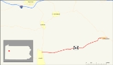
Pennsylvania Route 368 (designated by the Pennsylvania Department of Transportation
as SR 0368) is an 7.31 miles (11.8 km) long state highway
located in Armstrong
and Clarion
counties in Pennsylvania
. The western terminus is at PA 268
in Parker
. The eastern terminus is at PA 58
in Callensburg
. The highway was assigned in 1928 and on its current alignment by 1935, except for a change at the eastern terminus in 1967.
in Parker. Just after the eastern terminus, the highway crosses over the Allegheny on the Parker Bridge
. The highway crosses Perryville Road on an overpass, intersecting at a jughandle just after. After Perryville Road, State Route 368 enters a small, rural region of Parker Township. At the intersection of Terwillger Road, the highway enters the community of Parkers Landing. Paralleling Perryville Road to the south, State Route 368 passes a more suburban area of Parker Township. Just after leaving Parkers Landing, Perryville Road, which had been paralleling, merges back into the state route.
Hagertown Road then starts to parallel, but this also ends, with Hagertown merging in less than a half-mile later. After Hagertown Road, State Route 368 progresses straight to the northeast through a rural, undeveloped terrain. At a break in a surrounding forest, the highway begins to re-develop its surroundings, entering Perry Township. At Lime Plank Road and Doc Walker Road, State Route 368 enters the "downtown" community of Perry Township, leaving soon after for more forests. The highway continues farther, intersecting with Keefer Road. To the north, there is a large clearing, which also follows Keefer Road.
At the Myers Hollow Road intersection, State Route 368 turns off its eastern progression and onto a northeastern one. There is some development along the highway, but this is uncommon. Nearing another change in direction, the area becomes more developed. After Callensburg Road, State Route 368 makes a curve to the east, entering the borough of Callensburg. Changing officials name from Route 368 to Main Street, the highway enters the downtown area. At Scott Street, the highway is well-developed. However, this changed in reverse, crossing into a small patch of forests. After the forest turns to clearing, State Route 368 terminates at an intersection with State Route 58, Craig Road and High Lane, locally-maintained roads.
during 1928. Also, the highway extended farther than State Route 58 to State Route 68
in Sligo
. The entire highway at the time of assignment was not paved, save a couple of pieces. The highway was paved in 1930 from State Route 268 in Parker to the Perryville Road intersection. However, one piece was yet to be completed. In 1932, the section from West Freedom to Sligo was paved, completing the highway. In 1935, the highway was realigned off Perryville Road, and onto a constructed alignment. In 1967, the eastern terminus of State Route 368 was moved from its parent route (State Route 68) to an intersection with State Route 58 in Callensburg.
Pennsylvania Department of Transportation
The Pennsylvania Department of Transportation oversees transportation issues in the Commonwealth of Pennsylvania. The administrator of PennDOT is the Pennsylvania Secretary of Transportation, currently Barry Schoch Presently, PennDOT supports over of state roads and highways, about 25,000...
as SR 0368) is an 7.31 miles (11.8 km) long state highway
State highway
State highway, state road or state route can refer to one of three related concepts, two of them related to a state or provincial government in a country that is divided into states or provinces :#A...
located in Armstrong
Armstrong County, Pennsylvania
Armstrong County is a county located in the U.S. state of Pennsylvania. As of the 2010 census, the population was 68,941. It is located northeast of Pittsburgh and Allegheny County. Armstrong County was added to the Pittsburgh Metropolitan Statistical Area in 2003.The county seat is Kittanning...
and Clarion
Clarion County, Pennsylvania
As of the census of 2000, there were 41,765 people, 16,052 households, and 10,738 families residing in the county. The population density was 69 people per square mile . There were 19,426 housing units at an average density of 32 per square mile...
counties in Pennsylvania
Pennsylvania
The Commonwealth of Pennsylvania is a U.S. state that is located in the Northeastern and Mid-Atlantic regions of the United States. The state borders Delaware and Maryland to the south, West Virginia to the southwest, Ohio to the west, New York and Ontario, Canada, to the north, and New Jersey to...
. The western terminus is at PA 268
Pennsylvania Route 268
Pennsylvania Route 268 is a long state highway located in Armstrong, Butler, and Venango counties in Pennsylvania. The southern terminus is at US 422 in West Kittanning. The northern terminus is at PA 38/PA 208 in Emlenton.-Route description:...
in Parker
Parker, Pennsylvania
Parker is a city located in Armstrong County, Pennsylvania, United States. It is located in the extreme northwestern portion of the county. The population was 799 at the 2000 census. The city was named for John Parker, a lead surveyor of Lawrenceburg....
. The eastern terminus is at PA 58
Pennsylvania Route 58
Pennsylvania Route 58 is located in Western Pennsylvania, running 71.2 miles from the Ohio state line west of Jamestown in Mercer County to Sligo in Clarion County.-Mercer County:...
in Callensburg
Callensburg, Pennsylvania
Callensburg is a borough in Clarion County, Pennsylvania, United States. The population was 224 at the 2000 census.-Geography:Callensburg is located at ....
. The highway was assigned in 1928 and on its current alignment by 1935, except for a change at the eastern terminus in 1967.
Route description
State Route 368 begins at an intersection with State Route 268 (River Road) on the shores of the Allegheny RiverAllegheny River
The Allegheny River is a principal tributary of the Ohio River; it is located in the Eastern United States. The Allegheny River joins with the Monongahela River to form the Ohio River at the "Point" of Point State Park in Downtown Pittsburgh, Pennsylvania...
in Parker. Just after the eastern terminus, the highway crosses over the Allegheny on the Parker Bridge
Parker Bridge
Parker Bridge is a truss bridge in the city of Parker, Pennsylvania in the United States. The bridge, constructed in 1934, carries motor vehicles, and pedestrians over the Allegheny River.- External links :*...
. The highway crosses Perryville Road on an overpass, intersecting at a jughandle just after. After Perryville Road, State Route 368 enters a small, rural region of Parker Township. At the intersection of Terwillger Road, the highway enters the community of Parkers Landing. Paralleling Perryville Road to the south, State Route 368 passes a more suburban area of Parker Township. Just after leaving Parkers Landing, Perryville Road, which had been paralleling, merges back into the state route.
Hagertown Road then starts to parallel, but this also ends, with Hagertown merging in less than a half-mile later. After Hagertown Road, State Route 368 progresses straight to the northeast through a rural, undeveloped terrain. At a break in a surrounding forest, the highway begins to re-develop its surroundings, entering Perry Township. At Lime Plank Road and Doc Walker Road, State Route 368 enters the "downtown" community of Perry Township, leaving soon after for more forests. The highway continues farther, intersecting with Keefer Road. To the north, there is a large clearing, which also follows Keefer Road.
At the Myers Hollow Road intersection, State Route 368 turns off its eastern progression and onto a northeastern one. There is some development along the highway, but this is uncommon. Nearing another change in direction, the area becomes more developed. After Callensburg Road, State Route 368 makes a curve to the east, entering the borough of Callensburg. Changing officials name from Route 368 to Main Street, the highway enters the downtown area. At Scott Street, the highway is well-developed. However, this changed in reverse, crossing into a small patch of forests. After the forest turns to clearing, State Route 368 terminates at an intersection with State Route 58, Craig Road and High Lane, locally-maintained roads.
History
State Route 368 was assigned in the mass numbering of state highways in PennsylvaniaPennsylvania
The Commonwealth of Pennsylvania is a U.S. state that is located in the Northeastern and Mid-Atlantic regions of the United States. The state borders Delaware and Maryland to the south, West Virginia to the southwest, Ohio to the west, New York and Ontario, Canada, to the north, and New Jersey to...
during 1928. Also, the highway extended farther than State Route 58 to State Route 68
Pennsylvania Route 68
Pennsylvania Route 68 is a long east–west state highway located in western Pennsylvania in the United States. The western terminus of the route is at the Ohio state line west of Glasgow, where PA 68 continues into Ohio as State Route 39. The eastern terminus is at U.S...
in Sligo
Sligo, Pennsylvania
Sligo is a borough in Clarion County, Pennsylvania, United States. The population was 728 at the 2000 census.It was named after the town and county of Sligo in Ireland.-Geography:Sligo is located at ....
. The entire highway at the time of assignment was not paved, save a couple of pieces. The highway was paved in 1930 from State Route 268 in Parker to the Perryville Road intersection. However, one piece was yet to be completed. In 1932, the section from West Freedom to Sligo was paved, completing the highway. In 1935, the highway was realigned off Perryville Road, and onto a constructed alignment. In 1967, the eastern terminus of State Route 368 was moved from its parent route (State Route 68) to an intersection with State Route 58 in Callensburg.