

Peabody River
Encyclopedia
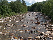
River
A river is a natural watercourse, usually freshwater, flowing towards an ocean, a lake, a sea, or another river. In a few cases, a river simply flows into the ground or dries up completely before reaching another body of water. Small rivers may also be called by several other names, including...
in the White Mountains
White Mountains (New Hampshire)
The White Mountains are a mountain range covering about a quarter of the state of New Hampshire and a small portion of western Maine in the United States. Part of the Appalachian Mountains, they are considered the most rugged mountains in New England...
of New Hampshire
New Hampshire
New Hampshire is a state in the New England region of the northeastern United States of America. The state was named after the southern English county of Hampshire. It is bordered by Massachusetts to the south, Vermont to the west, Maine and the Atlantic Ocean to the east, and the Canadian...
in the United States
United States
The United States of America is a federal constitutional republic comprising fifty states and a federal district...
. It is a tributary of the Androscoggin River
Androscoggin River
The Androscoggin River is a river in the U.S. states of Maine and New Hampshire, in northern New England. It is long and joins the Kennebec River at Merrymeeting Bay in Maine before its water empties into the Gulf of Maine on the Atlantic Ocean. Its drainage basin is in area...
, which flows south and east into Maine
Maine
Maine is a state in the New England region of the northeastern United States, bordered by the Atlantic Ocean to the east and south, New Hampshire to the west, and the Canadian provinces of Quebec to the northwest and New Brunswick to the northeast. Maine is both the northernmost and easternmost...
, joining the Kennebec River
Kennebec River
The Kennebec River is a river that is entirely within the U.S. state of Maine. It rises in Moosehead Lake in west-central Maine. The East and West Outlets join at Indian Pond and the river then flows southward...
near the Atlantic Ocean
Atlantic Ocean
The Atlantic Ocean is the second-largest of the world's oceanic divisions. With a total area of about , it covers approximately 20% of the Earth's surface and about 26% of its water surface area...
.
The Peabody River rises in Pinkham Notch
Pinkham Notch
Pinkham Notch is a mountain pass in the White Mountains of north-central New Hampshire, United States. The notch is a result of extensive erosion by the Laurentide ice sheet during the Wisconsinian ice age. Pinkham Notch was eroded into a glacial U-shaped valley whose walls are formed by the...
, on the eastern slopes of Mount Washington
Mount Washington (New Hampshire)
Mount Washington is the highest peak in the Northeastern United States at , famous for dangerously erratic weather. For 76 years, a weather observatory on the summit held the record for the highest wind gust directly measured at the Earth's surface, , on the afternoon of April 12, 1934...
. The river flows northeast to the Androscoggin River in Gorham, New Hampshire
Gorham, New Hampshire
Gorham is a town in Coos County, New Hampshire, United States. The population was 2,848 at the 2010 census. Gorham is located in the White Mountains, and parts of the White Mountain National Forest are in the south and northwest. Moose Brook State Park is in the west. The town is crossed by the...
, collecting tributaries from the Presidential Range
Presidential Range
The Presidential Range is a mountain range located in the White Mountains of the U.S. state of New Hampshire. Containing the highest peaks of the Whites, its most notable summits are named for American Presidents, followed by prominent public figures of the 18th and 19th centuries.Mt...
to the west and the Carter-Moriah Range
Carter-Moriah Range
The Carter-Moriah Range of mountains is located in the White Mountains, in Coos County, New Hampshire. The range forms the northern east side of Pinkham Notch, opposite the northern Presidential Range.- Summits :From north to south:...
to the east. Its most significant tributary is the West Branch
West Branch Peabody River
The West Branch of the Peabody River is a 5.8 mile long river in the White Mountains of New Hampshire in the United States. It is a tributary of the Peabody River, which flows into the Androscoggin River, which in turn flows south and east into Maine, joining the Kennebec River near the Atlantic...
of the Peabody River, emerging from Great Gulf
Great Gulf
The Great Gulf is a glacial cirque, or amphitheater-like valley head formed from a glacier by erosion, located in the White Mountains of New Hampshire...
, a deep and long glacial cirque
Cirque (landform)
thumb|250 px|Two cirques with semi-permanent snowpatches in [[Abisko National Park]], [[Sweden]].A cirque or corrie is an amphitheatre-like valley head, formed at the head of a valley glacier by erosion...
surrounded by the peaks of the Presidential Range.
New Hampshire Route 16
New Hampshire Route 16
New Hampshire Route 16 is a long north–south highway in the U.S. state of New Hampshire. Much of its length is close to the border with Maine. NH 16 is the main route from the Seacoast region north to the Lakes Region and the White Mountains. The section from Portsmouth to Milton is a...
follows the Peabody River for most of the river's length.