
Pinkham Notch
Encyclopedia
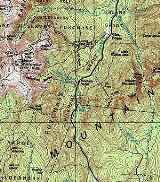
Pinkham Notch is a mountain pass
in the White Mountains
of north-central New Hampshire
, United States
. The notch is a result of extensive erosion by the Laurentide ice sheet
during the Wisconsinian ice age
. Pinkham Notch was eroded into a glacial U-shaped valley whose walls are formed by the Presidential
, Wildcat
, and Carter-Moriah
ranges. Due to the volatility of the area's climate and rugged character of the terrain, a number of rare or endemic ecosystems have developed throughout the notch.
The notch was discovered in 1784 by Jeremy Belknap, but its isolation prevented further development for several years. The construction of New Hampshire Route 16
has led to increased accessibility and a rise in tourism. Its location makes it a hub for hiking and skiing.
The locally famed "Dead man's curve" is located in Pinkham Notch. Some truckers have had trouble negotiating the curve in inclement weather. There is also a pull off area for beautiful views.
, which forms the western wall, from the Wildcat Range
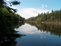
, which forms the eastern wall. Two rivers drain the notch; the Ellis River drains the south end and is a tributary of the Saco
, and the Peabody River
drains the north end and is a tributary of the Androscoggin
.
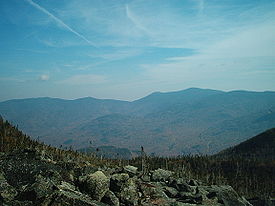
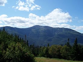 The bulk of the western slope of the notch is formed by Mount Washington
, the highest peak in the northeast United States, reaching 6288 feet (1,916.6 m) above sea level. Mount Washington rises more than 4000 feet (1,219.2 m) above the floor of the notch. A number of glacial cirques
are found on this side of the notch. The Great Gulf
and its tributary cirques form the largest cirque in the White Mountains. South of the Great Gulf is Huntington Ravine
, with a rocky, precipitous headwall renowned for its rock and ice climbing. The slope then dips into the Ravine of Raymond Cataract, a non-glacial "V-shaped" valley with a notable waterfall. After this comes Tuckerman Ravine
, with a uniform, smoother headwall that is known for its high-quality skiing. After passing the Gulf of Slides, a smaller and lesser-known cirque, the notch opens up and continues until Jackson
.
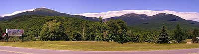
The eastern slope of the notch consists of the Wildcat and Carter-Moriah Range
s, slightly lower than the Presidential Range to the west. The Wildcat Range consists of five peaks, named A, B, C, D, and E from northeast to southwest in order of height. Wildcat A is the highest, at 4422 feet (1,347.8 m). From the main ridge, the slopes drop very steeply, but not precipitously, to the floor of the notch. The Wildcat Mountain Ski Area
occupies the western slopes of Wildcat up to the col
between D and E peaks. As the notch rounds E peak, the slope becomes extremely steep, and Wildcat Ridge begins to drop to the end of the notch.
The Carter-Moriah Range lies to the north of Wildcat Ridge, forming the eastern side of Pinkham Notch all the way to the Androscoggin River. From south to north, the peaks overlooking the notch are Carter Dome (4,832 ft / 1,473 m), Mount Hight
(4,675 ft / 1,425 m), South Carter Mountain
(4,420 ft / 1,347 m), Middle Carter Mountain
(4,600 ft / 1,402 m), North Carter Mountain
(4,530 ft / 1,381 m), Imp Mountain
(3,720 ft / 1,134 m), and Mount Moriah
(4,049 ft / 1,234 m).
s range from a low-elevation northern hardwood forest at the base of Mount Washington to alpine-Arctic vegetation near the summit comparable to vegetation found at the latitude of Labrador
.
 The lowest elevations of Pinkham Notch are occupied by a northern hardwood
forest. This forest type is primarily deciduous and consists mostly of sugar maple
, American beech
, and yellow birch
. There is also a proliferation of understory and forest floor plants; common examples include wild sasparilla, painted trillium
, hobblebush
, and Indian cucumber-root
.
The northern hardwood forest also contains the greatest diversity of animal life in the notch. Mammals include chipmunk
s, raccoon
s, white-tailed deer
, black bears
, and moose
. There are also a large number of birds in this forest; frequently seen are red-eyed vireos, hermit thrush
es, and ovenbird
s. Amphibians are also found in the northern hardwood forest. Red efts, the terrestrial stage of development for the red-spotted newt
, congregate in large numbers after heavy rains; also present are American toad
s, spring peeper
s, and wood frogs
.
At around 2000 feet (609.6 m), species from higher forest zones begin to mix with the northern hardwoods in what is known as the "transition zone". As elevation within this zone increases, species from the lower hardwood forest begin to drop out. By 2500 feet (762 m), yellow birch is the only deciduous species that remains, and the forest becomes a spruce-fir forest.
s" become the dominant species. Two trees, red spruce
and balsam fir
, are present throughout this zone, with paper birch
, striped maple
and mountain
ash present in its lower levels. Like the hardwood forest below it, the spruce-fir forest also holds understory plants; commonly found are wood sorrel, Indian pipes, Canada mayflowers
, and bluebead lilies
. Fungi are also common in the moist environment.
Most of the animals in the spruce-fir forest have ranges that extend into the balsam fir forest higher up. Warbler
s are abundant; more than ten species exist in this forest type. Other common birds include brown-capped chickadees
, spruce grouse
, and yellow-capped woodpeckers. Mammals include the red squirrel
and the pine marten
.
In the upper reaches of the balsam fir zone, winds and temperatures are extreme enough to force the trees into stunted, "bonsai-like" shapes. Known as krummholz
, from the German word for "crooked wood", trees in this area are often bent into bizarre shapes by the combined effects of wind, temperature, and airborne ice particles. Branches that are perpendicular to the prevailing winds are often killed, leaving "flag trees" that point in the direction of the wind. Eventually, conditions become extreme enough to prevent any tree growth; the elevation at which this occurs is known as tree line, and usually occurs at around 4,500 ft (1,400 m) in the White Mountains, depending on wind exposure.
" of alpine-Arctic vegetation exists. Vegetation in this zone tends to be lichen
s, sedges or small, low-lying plants that can resist the constant exposure to the wind. Most plants in this area are perennial; the growing season is far too short to allow for annuals.
Alpine plants usually occur in communities spaced between barren talus
slopes. Cushion-shaped diapensia
usually grows in communities in the windiest areas, and in less exposed sites sedge
, heath
, snowbank, and alpine bog communities can be found.
shaped it into its current form, a "U-shaped" valley. This shaping occurred during the Wisconsinian Ice Age
, 25–50,000 years ago. The geology of the region became greatly altered by this event; much of the weaker rock was stripped from the region, leaving only highly-resistant mica schist
. As the glacier
s retreated, a layer of glacial till was deposited, including several glacial erratics. A notable glacial erratic in the area is Mount Washington's Glen Boulder.
 The notch first appears in recorded history in 1784, when an expedition led by Jeremy Belknap
camped in the notch before ascending to the summit of Mount Washington through Huntington Ravine.. Pinkham Notch was far more isolated than neighboring Crawford Notch
; as a result, the first settler of Pinkham Notch came in 1827, 43 years after habitation of Crawford Notch. The first settler, Hayes Copp, built a homestead in the then-uninhabited area, near where the Dolly Copp campground stands today. Copp and his wife lived alone in the wilderness until Daniel Pinkham completed the first road through the notch between in 1836, finally providing a link between the Copp homestead and civilization. In 1851, a railroad was built to Gorham
, and a hotel, the Glen House, was constructed to accommodate passengers. Mount Washington was the main attraction in the area; a bridle path was constructed from the Glen House to hotels on the summit, which was later improved into what would become the Mount Washington Auto Road
. Completion of the road in 1861 led to a massive increase in tourism.
Meanwhile, logging began in the Pinkham area. After almost total deforestation of the White Mountain region, the White Mountain National Forest
was created in 1911, and the Mount Washington area was added to the national forest in 1914. With the preservation of the area, emphasis shifted from logging to recreation. The Appalachian Mountain Club
converted a logging camp near the height-of-land
into what is now the Pinkham Notch Visitor Center in 1921. The Appalachian Trail
was built through the visitor center, making it an important trailhead for ascents of Mount Washington. Meanwhile, ski trails began to be constructed by the Civilian Conservation Corps
on Wildcat Mountain, and the ski resort was opened in 1958.
. Numerous opportunities for recreation exist in the area.
 Mount Washington
is a common objective, and is often climbed from Pinkham Notch. There are numerous trail approaches from the Appalachian Mountain Club
's visitor's center. Although trail distances seem short, the trip to the summit should not be underestimated; most trail approaches involve at least 4,000 vertical feet (1,200 m) of climbing, including an ascent of the rocky summit cone and the boulder-strewn upper slopes. Weather changes very quickly, and one must be prepared for extreme conditions. The Tuckerman Ravine Trail is the most popular trail in the notch, ascending to the summit via the headwall of Tuckerman Ravine. The Huntington Ravine Trail is widely considered the most difficult trail in New Hampshire, making its way up the precipitous headwall of neighboring Huntington Ravine, where there are several rock climbing opportunities.
On the other side of the notch, the Wildcat Range is a popular objective. The five summits can be reached via the Wildcat Ridge Trail; the first two miles are extremely difficult, and require skill on short, yet exposed, rock scrambles
. This part of the trail is frequently bypassed by following the ski area's Polecat Trail to the summit of D Peak.
The Appalachian Trail
, which extends over 2150 miles (3,460.1 km) from Georgia
to Maine
, runs along the Presidential Range before crossing the notch and ascending to the summits of the Wildcat Range.
There are also less challenging hikes that are equally scenic, yet better suited for families with young children. Popular objectives include Glen Ellis Falls, a waterfall on the Ellis River, and Square Ledge, with an impressive view of Mount Washington for modest effort.
 The area also has many opportunities for both alpine
and Nordic
skiing. The bowl of Tuckerman Ravine is famous for its extremely steep backcountry skiing. Long lines are common during the peak spring-skiing season of April and May. Wildcat Mountain offers groomed ski trails and lifts, and is a better choice for less-experienced skiers. The centerpiece of the ski-area is the gondola
, which runs during the summer, and offers views of the Presidentials with no expended effort.
For Nordic skiing, Great Glen Trails offers a large, groomed trail system that also includes the lower half of the Auto Road. Several warming huts are scattered around the trail system, including scenic Great Angel Cabin, with views of the Great Gulf and surrounding peaks. Great Glen also permits biking on the trails during the summer, and is the only mountain bike facility in the notch. Another cross-country trail system exists in the town of Jackson
, extending as far as the summit of Wildcat Mountain.
Mountain pass
A mountain pass is a route through a mountain range or over a ridge. If following the lowest possible route, a pass is locally the highest point on that route...
in the White Mountains
White Mountains (New Hampshire)
The White Mountains are a mountain range covering about a quarter of the state of New Hampshire and a small portion of western Maine in the United States. Part of the Appalachian Mountains, they are considered the most rugged mountains in New England...
of north-central New Hampshire
New Hampshire
New Hampshire is a state in the New England region of the northeastern United States of America. The state was named after the southern English county of Hampshire. It is bordered by Massachusetts to the south, Vermont to the west, Maine and the Atlantic Ocean to the east, and the Canadian...
, United States
United States
The United States of America is a federal constitutional republic comprising fifty states and a federal district...
. The notch is a result of extensive erosion by the Laurentide ice sheet
Laurentide ice sheet
The Laurentide Ice Sheet was a massive sheet of ice that covered hundreds of thousands of square miles, including most of Canada and a large portion of the northern United States, multiple times during Quaternary glacial epochs. It last covered most of northern North America between c. 95,000 and...
during the Wisconsinian ice age
Wisconsin glaciation
The last glacial period was the most recent glacial period within the current ice age occurring during the last years of the Pleistocene, from approximately 110,000 to 10,000 years ago....
. Pinkham Notch was eroded into a glacial U-shaped valley whose walls are formed by the Presidential
Presidential Range
The Presidential Range is a mountain range located in the White Mountains of the U.S. state of New Hampshire. Containing the highest peaks of the Whites, its most notable summits are named for American Presidents, followed by prominent public figures of the 18th and 19th centuries.Mt...
, Wildcat
Wildcat Mountain (New Hampshire)
Wildcat Mountain is a mountain located in Coos County, northern New Hampshire, United States. The mountain is part of the Carter-Moriah Range of the White Mountains, on the east side of Pinkham Notch...
, and Carter-Moriah
Carter-Moriah Range
The Carter-Moriah Range of mountains is located in the White Mountains, in Coos County, New Hampshire. The range forms the northern east side of Pinkham Notch, opposite the northern Presidential Range.- Summits :From north to south:...
ranges. Due to the volatility of the area's climate and rugged character of the terrain, a number of rare or endemic ecosystems have developed throughout the notch.
The notch was discovered in 1784 by Jeremy Belknap, but its isolation prevented further development for several years. The construction of New Hampshire Route 16
New Hampshire Route 16
New Hampshire Route 16 is a long north–south highway in the U.S. state of New Hampshire. Much of its length is close to the border with Maine. NH 16 is the main route from the Seacoast region north to the Lakes Region and the White Mountains. The section from Portsmouth to Milton is a...
has led to increased accessibility and a rise in tourism. Its location makes it a hub for hiking and skiing.
The locally famed "Dead man's curve" is located in Pinkham Notch. Some truckers have had trouble negotiating the curve in inclement weather. There is also a pull off area for beautiful views.
Geography
The notch separates the Presidential RangePresidential Range
The Presidential Range is a mountain range located in the White Mountains of the U.S. state of New Hampshire. Containing the highest peaks of the Whites, its most notable summits are named for American Presidents, followed by prominent public figures of the 18th and 19th centuries.Mt...
, which forms the western wall, from the Wildcat Range
Wildcat Mountain (New Hampshire)
Wildcat Mountain is a mountain located in Coos County, northern New Hampshire, United States. The mountain is part of the Carter-Moriah Range of the White Mountains, on the east side of Pinkham Notch...
, which forms the eastern wall. Two rivers drain the notch; the Ellis River drains the south end and is a tributary of the Saco
Saco River
The Saco River is a river in northeastern New Hampshire and southwestern Maine in the United States. It drains a rural area of of forests and farmlands west and southwest of Portland, emptying into the Atlantic Ocean at Saco Bay, from its source. It supplies drinking water to roughly 250,000...
, and the Peabody River
Peabody River
The Peabody River is a 12.9 mile long river in the White Mountains of New Hampshire in the United States. It is a tributary of the Androscoggin River, which flows south and east into Maine, joining the Kennebec River near the Atlantic Ocean....
drains the north end and is a tributary of the Androscoggin
Androscoggin River
The Androscoggin River is a river in the U.S. states of Maine and New Hampshire, in northern New England. It is long and joins the Kennebec River at Merrymeeting Bay in Maine before its water empties into the Gulf of Maine on the Atlantic Ocean. Its drainage basin is in area...
.
Mount Washington (New Hampshire)
Mount Washington is the highest peak in the Northeastern United States at , famous for dangerously erratic weather. For 76 years, a weather observatory on the summit held the record for the highest wind gust directly measured at the Earth's surface, , on the afternoon of April 12, 1934...
, the highest peak in the northeast United States, reaching 6288 feet (1,916.6 m) above sea level. Mount Washington rises more than 4000 feet (1,219.2 m) above the floor of the notch. A number of glacial cirques
Cirque (landform)
thumb|250 px|Two cirques with semi-permanent snowpatches in [[Abisko National Park]], [[Sweden]].A cirque or corrie is an amphitheatre-like valley head, formed at the head of a valley glacier by erosion...
are found on this side of the notch. The Great Gulf
Great Gulf
The Great Gulf is a glacial cirque, or amphitheater-like valley head formed from a glacier by erosion, located in the White Mountains of New Hampshire...
and its tributary cirques form the largest cirque in the White Mountains. South of the Great Gulf is Huntington Ravine
Huntington Ravine
Huntington Ravine is a glacial cirque on Mount Washington in the White Mountains of New Hampshire. It is named for Joshua H. Huntington, the Principal Assistant to State Geologist Charles H...
, with a rocky, precipitous headwall renowned for its rock and ice climbing. The slope then dips into the Ravine of Raymond Cataract, a non-glacial "V-shaped" valley with a notable waterfall. After this comes Tuckerman Ravine
Tuckerman Ravine
Tuckerman Ravine is a glacial cirque sloping eastward on the southeast face of Mt. Washington, in the White Mountains of New Hampshire. Although it draws hikers throughout the year, and skiers throughout the winter, it is best known for the many "spring skiers" who ascend it on foot and ski down...
, with a uniform, smoother headwall that is known for its high-quality skiing. After passing the Gulf of Slides, a smaller and lesser-known cirque, the notch opens up and continues until Jackson
Jackson, New Hampshire
Jackson is a town in Carroll County, New Hampshire, United States. The population was 816 at the 2010 census. Jackson is an elegant resort area in the White Mountains. Parts of the White Mountain National Forest are in the west, north and east...
.
The eastern slope of the notch consists of the Wildcat and Carter-Moriah Range
Carter-Moriah Range
The Carter-Moriah Range of mountains is located in the White Mountains, in Coos County, New Hampshire. The range forms the northern east side of Pinkham Notch, opposite the northern Presidential Range.- Summits :From north to south:...
s, slightly lower than the Presidential Range to the west. The Wildcat Range consists of five peaks, named A, B, C, D, and E from northeast to southwest in order of height. Wildcat A is the highest, at 4422 feet (1,347.8 m). From the main ridge, the slopes drop very steeply, but not precipitously, to the floor of the notch. The Wildcat Mountain Ski Area
Wildcat Mountain Ski Area
Wildcat Mountain Ski Area is a ski area located on Wildcat Mountain near Jackson, New Hampshire in the Mount Washington Valley. Its vertical drop of is the second largest in New Hampshire and the ninth largest in New England....
occupies the western slopes of Wildcat up to the col
Mountain pass
A mountain pass is a route through a mountain range or over a ridge. If following the lowest possible route, a pass is locally the highest point on that route...
between D and E peaks. As the notch rounds E peak, the slope becomes extremely steep, and Wildcat Ridge begins to drop to the end of the notch.
The Carter-Moriah Range lies to the north of Wildcat Ridge, forming the eastern side of Pinkham Notch all the way to the Androscoggin River. From south to north, the peaks overlooking the notch are Carter Dome (4,832 ft / 1,473 m), Mount Hight
Mount Hight
Mount Hight is a mountain located in Coos County, New Hampshire. The mountain is part of the Carter-Moriah Range of the White Mountains, which runs along the eastern-northeastern side of Pinkham Notch...
(4,675 ft / 1,425 m), South Carter Mountain
South Carter Mountain
South Carter Mountain is a mountain located in Coos County, New Hampshire. The mountain is part of the Carter-Moriah Range of the White Mountains, which runs along the northern east side of Pinkham Notch...
(4,420 ft / 1,347 m), Middle Carter Mountain
Middle Carter Mountain
Middle Carter Mountain is a mountain located in Coos County, New Hampshire. The mountain is part of the Carter-Moriah Range of the White Mountains, which runs along the northern east side of Pinkham Notch. Middle Carter is flanked to the north by North Carter Mountain, and to the southwest by...
(4,600 ft / 1,402 m), North Carter Mountain
North Carter Mountain
North Carter Mountain is a mountain located in Coos County, New Hampshire. The mountain is part of the Carter-Moriah Range of the White Mountains, which runs along the northern east side of Pinkham Notch...
(4,530 ft / 1,381 m), Imp Mountain
Imp Mountain
Imp Mountain is a mountain located in Coos County, New Hampshire. The mountain is part of the Carter-Moriah Range of the White Mountains, which runs along the northern east side of Pinkham Notch. Imp Mountain is flanked to the northeast by Mount Moriah, and to the southwest by North Carter...
(3,720 ft / 1,134 m), and Mount Moriah
Mount Moriah (New Hampshire)
Mount Moriah is a mountain located in Coos County, New Hampshire. The mountain is part of the Carter-Moriah Range of the White Mountains, which runs along the northern east side of Pinkham Notch. The summit is approximately southeast of the center of the town of Gorham...
(4,049 ft / 1,234 m).
Environment
The climate, and as a result, the flora and fauna, of Pinkham Notch varies greatly with elevation. As elevations increase on the walls of the notch, climate and ecosystems change to those of increasingly northern occurrence. BiomeBiome
Biomes are climatically and geographically defined as similar climatic conditions on the Earth, such as communities of plants, animals, and soil organisms, and are often referred to as ecosystems. Some parts of the earth have more or less the same kind of abiotic and biotic factors spread over a...
s range from a low-elevation northern hardwood forest at the base of Mount Washington to alpine-Arctic vegetation near the summit comparable to vegetation found at the latitude of Labrador
Labrador
Labrador is the distinct, northerly region of the Canadian province of Newfoundland and Labrador. It comprises the mainland portion of the province, separated from the island of Newfoundland by the Strait of Belle Isle...
.
Below 2500 ft. — Northern hardwood forest
Hardwood
Hardwood is wood from angiosperm trees . It may also be used for those trees themselves: these are usually broad-leaved; in temperate and boreal latitudes they are mostly deciduous, but in tropics and subtropics mostly evergreen.Hardwood contrasts with softwood...
forest. This forest type is primarily deciduous and consists mostly of sugar maple
Sugar Maple
Acer saccharum is a species of maple native to the hardwood forests of northeastern North America, from Nova Scotia west to southern Ontario, and south to Georgia and Texas...
, American beech
American Beech
Fagus grandifolia, also known as American Beech or North american beech, is a species of beech native to eastern North America, from Nova Scotia west to southern Ontario in southeastern Canada, west to Wisconsin and south to eastern Texas and northern Florida in the United States. Trees in the...
, and yellow birch
Yellow Birch
Betula alleghaniensis , is a species of birch native to eastern North America, from Newfoundland to Nova Scotia, New Brunswick, southern Quebec and Ontario, and the southeast corner of Manitoba in Canada, west to Minnesota, and south in the Appalachian Mountains to northern Georgia.It is a...
. There is also a proliferation of understory and forest floor plants; common examples include wild sasparilla, painted trillium
Trillium
Trillium is a genus of about 40–50 species of spring ephemeral perennials, native to temperate regions of North America and Asia....
, hobblebush
Viburnum
Viburnum is a genus of about 150–175 species of shrubs or small trees in the moschatel family, Adoxaceae. Its current classification is based on molecular phylogeny...
, and Indian cucumber-root
Medeola virginiana
Medeola virginiana or Indian Cucumber-root is a perennial plant in the genus Medeola.-Description:It occurs with either a single tier or two tiers of leaves. The upper tier consists of from three to five whorled leaves on the stem above a lower tier of five to nine...
.
The northern hardwood forest also contains the greatest diversity of animal life in the notch. Mammals include chipmunk
Chipmunk
Chipmunks are small striped squirrels native to North America and Asia. They are usually classed either as a single genus with three subgenera, or as three genera.-Etymology and taxonomy:...
s, raccoon
Raccoon
Procyon is a genus of nocturnal mammals, comprising three species commonly known as raccoons, in the family Procyonidae. The most familiar species, the common raccoon , is often known simply as "the" raccoon, as the two other raccoon species in the genus are native only to the tropics and are...
s, white-tailed deer
White-tailed Deer
The white-tailed deer , also known as the Virginia deer or simply as the whitetail, is a medium-sized deer native to the United States , Canada, Mexico, Central America, and South America as far south as Peru...
, black bears
American black bear
The American black bear is a medium-sized bear native to North America. It is the continent's smallest and most common bear species. Black bears are omnivores, with their diets varying greatly depending on season and location. They typically live in largely forested areas, but do leave forests in...
, and moose
Moose
The moose or Eurasian elk is the largest extant species in the deer family. Moose are distinguished by the palmate antlers of the males; other members of the family have antlers with a dendritic configuration...
. There are also a large number of birds in this forest; frequently seen are red-eyed vireos, hermit thrush
Hermit Thrush
The Hermit Thrush is a medium-sized North American thrush. It is not very closely related to the other North American migrant species of Catharus, but rather to the Mexican Russet Nightingale-thrush.-Description:...
es, and ovenbird
Ovenbird
The Ovenbird is a small songbird of the New World warbler family . This migratory bird breeds in eastern North America and moves south in winter.-Taxonomy:...
s. Amphibians are also found in the northern hardwood forest. Red efts, the terrestrial stage of development for the red-spotted newt
Eastern Newt
The Eastern Newt or Red-spotted Newt is a common salamander of eastern North America. Eastern newts dwell in wet forests with small lakes or ponds. They can coexist in an aquatic environment with fish, however, their skin secretes a poisonous substance when the newt is threatened or injured...
, congregate in large numbers after heavy rains; also present are American toad
American toad
The American Toad is a common species of toad found throughout the eastern United States and Canada. It is divided into three subspecies—the Eastern American Toad , the Dwarf American Toad , and the rare Hudson Bay Toad...
s, spring peeper
Spring Peeper
The Spring Peeper is a small chorus frog widespread throughout the eastern USA and Canada.-Subspecies:There are two subspecies of the Spring Peeper, the Northern and the Southern Spring Peeper . The Northern is similar to the Southern except for a strong dark marking on the Southern frog's belly...
s, and wood frogs
Wood Frog
The Wood Frog has a broad distribution over North America, extending from the southern Appalachians to the boreal forest with several notable disjunct populations including lowland eastern North Carolina...
.
At around 2000 feet (609.6 m), species from higher forest zones begin to mix with the northern hardwoods in what is known as the "transition zone". As elevation within this zone increases, species from the lower hardwood forest begin to drop out. By 2500 feet (762 m), yellow birch is the only deciduous species that remains, and the forest becomes a spruce-fir forest.
2500 ft. to 4000 ft. — Spruce/fir forest
As elevation increases, the forest is subjected to colder temperatures, increased moisture, and acidic, infertile soils. As a result, conifers, or "softwoodSoftwood
The term softwood is used to describe wood from trees that are known as gymnosperms.Conifers are an example. It may also be used to describe trees, which tend to be evergreen, notable exceptions being bald cypress and the larches....
s" become the dominant species. Two trees, red spruce
Red Spruce
Picea rubens is a species of spruce native to eastern North America, ranging from eastern Quebec to Nova Scotia, and from New England south in the Adirondack Mountains and Appalachians to western North Carolina.-Physical description:...
and balsam fir
Balsam Fir
The balsam fir is a North American fir, native to most of eastern and central Canada and the northeastern United States .-Growth:It is a small to medium-size evergreen tree typically tall, rarely to tall, with a narrow conic crown...
, are present throughout this zone, with paper birch
Paper Birch
Betula papyrifera is a species of birch native to northern North America.-Description:...
, striped maple
Striped Maple
Acer pensylvanicum is a species of maple native to northern and montane forests in eastern North America from southern Ontario east to Nova Scotia and south to Wisconsin, Ohio, and New Jersey, and also at higher elevations in the Appalachian Mountains south to northern Georgia.It is a small...
and mountain
Mountain
Image:Himalaya_annotated.jpg|thumb|right|The Himalayan mountain range with Mount Everestrect 58 14 160 49 Chomo Lonzorect 200 28 335 52 Makalurect 378 24 566 45 Mount Everestrect 188 581 920 656 Tibetan Plateaurect 250 406 340 427 Rong River...
ash present in its lower levels. Like the hardwood forest below it, the spruce-fir forest also holds understory plants; commonly found are wood sorrel, Indian pipes, Canada mayflowers
Maianthemum canadense
Maianthemum canadense Maianthemum canadense Maianthemum canadense (Canadian May-lily, Canada Mayflower, False Lily-of-the-valley, Canadian Lily-of-the-valley, Wild Lily-of-the-valley, Two-leaved Solomonseal; syn. Maianthemum canadense var. interius Fern., Maianthemum canadense var...
, and bluebead lilies
Blue-bead lily
Clintonia borealis , is a perennial forest plant found in eastern North America...
. Fungi are also common in the moist environment.
Most of the animals in the spruce-fir forest have ranges that extend into the balsam fir forest higher up. Warbler
Warbler
There are a number of Passeriformes called "warblers". They are not particularly closely related, but share some characteristics, such as being fairly small, vocal and insectivorous....
s are abundant; more than ten species exist in this forest type. Other common birds include brown-capped chickadees
Boreal Chickadee
The Boreal Chickadee is a small passerine bird in the tit family Paridae.-Description:...
, spruce grouse
Spruce Grouse
The Spruce Grouse or Canada Grouse is a medium-sized grouse closely associated with the coniferous boreal forests or taiga of North America. It is one of the most arboreal grouse, fairly well adapted to perching and moving about in trees...
, and yellow-capped woodpeckers. Mammals include the red squirrel
Red Squirrel
The red squirrel or Eurasian red squirrel is a species of tree squirrel in the genus Sciurus common throughout Eurasia...
and the pine marten
Pine Marten
The European Pine Marten , known most commonly as the pine marten in Anglophone Europe, and less commonly also known as Pineten, baum marten, or sweet marten, is an animal native to Northern Europe belonging to the mustelid family, which also includes mink, otter, badger, wolverine and weasel. It...
.
4000 ft. to timberline — Balsam fir forest
As elevation continues to increase, only the hardiest trees remain in the forest, which is composed almost exclusively of balsam fir. Most of the understory plants and animals from the upper spruce-fir zone, however, can be found in this forest. Moisture causes nutrients to be stripped from the soil and brought to lower elevations, and decomposition takes place at a rate that is too slow to replenish them.In the upper reaches of the balsam fir zone, winds and temperatures are extreme enough to force the trees into stunted, "bonsai-like" shapes. Known as krummholz
Krummholz
Krummholz or Krumholtz formation — also called Knieholz — is a particular feature of subarctic and subalpine tree line landscapes. Continual exposure to fierce, freezing winds causes vegetation to become stunted and deformed...
, from the German word for "crooked wood", trees in this area are often bent into bizarre shapes by the combined effects of wind, temperature, and airborne ice particles. Branches that are perpendicular to the prevailing winds are often killed, leaving "flag trees" that point in the direction of the wind. Eventually, conditions become extreme enough to prevent any tree growth; the elevation at which this occurs is known as tree line, and usually occurs at around 4,500 ft (1,400 m) in the White Mountains, depending on wind exposure.
Above timberline — The alpine zone
On the highest slopes of the west wall of the notch, trees are unable to grow, and an "alpine zoneAlpine tundra
Alpine tundra is a natural region that does not contain trees because it is at high altitude. Alpine tundra is distinguished from arctic tundra, because alpine soils are generally better drained than arctic soils...
" of alpine-Arctic vegetation exists. Vegetation in this zone tends to be lichen
Lichen
Lichens are composite organisms consisting of a symbiotic organism composed of a fungus with a photosynthetic partner , usually either a green alga or cyanobacterium...
s, sedges or small, low-lying plants that can resist the constant exposure to the wind. Most plants in this area are perennial; the growing season is far too short to allow for annuals.
Alpine plants usually occur in communities spaced between barren talus
Scree
Scree, also called talus, is a term given to an accumulation of broken rock fragments at the base of crags, mountain cliffs, or valley shoulders. Landforms associated with these materials are sometimes called scree slopes or talus piles...
slopes. Cushion-shaped diapensia
Diapensia
Diapensia lapponica is a plant in the family Diapensiaceae, the only circumpolar species in the genus Diapensia, the others being mainly in the Himalayas. It is a circumboreal arctic-alpine species which grows on exposed rocky ridges that are kept free from snow by high winds .It is a small...
usually grows in communities in the windiest areas, and in less exposed sites sedge
Cyperaceae
Cyperaceae are a family of monocotyledonous graminoid flowering plants known as sedges, which superficially resemble grasses or rushes. The family is large, with some 5,500 species described in about 109 genera. These species are widely distributed, with the centers of diversity for the group...
, heath
Ericaceae
The Ericaceae, commonly known as the heath or heather family, is a group of mostly calcifuge flowering plants. The family is large, with roughly 4000 species spread across 126 genera, making it the 14th most speciose family of flowering plants...
, snowbank, and alpine bog communities can be found.
History
Pinkham Notch was originally a riverine, "V-shaped" valley until the Laurentide Ice SheetLaurentide ice sheet
The Laurentide Ice Sheet was a massive sheet of ice that covered hundreds of thousands of square miles, including most of Canada and a large portion of the northern United States, multiple times during Quaternary glacial epochs. It last covered most of northern North America between c. 95,000 and...
shaped it into its current form, a "U-shaped" valley. This shaping occurred during the Wisconsinian Ice Age
Wisconsin glaciation
The last glacial period was the most recent glacial period within the current ice age occurring during the last years of the Pleistocene, from approximately 110,000 to 10,000 years ago....
, 25–50,000 years ago. The geology of the region became greatly altered by this event; much of the weaker rock was stripped from the region, leaving only highly-resistant mica schist
Schist
The schists constitute a group of medium-grade metamorphic rocks, chiefly notable for the preponderance of lamellar minerals such as micas, chlorite, talc, hornblende, graphite, and others. Quartz often occurs in drawn-out grains to such an extent that a particular form called quartz schist is...
. As the glacier
Glacier
A glacier is a large persistent body of ice that forms where the accumulation of snow exceeds its ablation over many years, often centuries. At least 0.1 km² in area and 50 m thick, but often much larger, a glacier slowly deforms and flows due to stresses induced by its weight...
s retreated, a layer of glacial till was deposited, including several glacial erratics. A notable glacial erratic in the area is Mount Washington's Glen Boulder.
Jeremy Belknap
Jeremy Belknap was an American clergyman and historian. His great achievement was the "History of New Hampshire", published in three volumes between 1784 and 1792. This work is the first modern history written by an American, embodying a new rigor in research, annotation, and reporting.Jeremy was...
camped in the notch before ascending to the summit of Mount Washington through Huntington Ravine.. Pinkham Notch was far more isolated than neighboring Crawford Notch
Crawford Notch
Crawford Notch is the steep and narrow gorge of the Saco River in the White Mountains of New Hampshire, located almost entirely within the town of Hart's Location...
; as a result, the first settler of Pinkham Notch came in 1827, 43 years after habitation of Crawford Notch. The first settler, Hayes Copp, built a homestead in the then-uninhabited area, near where the Dolly Copp campground stands today. Copp and his wife lived alone in the wilderness until Daniel Pinkham completed the first road through the notch between in 1836, finally providing a link between the Copp homestead and civilization. In 1851, a railroad was built to Gorham
Gorham, New Hampshire
Gorham is a town in Coos County, New Hampshire, United States. The population was 2,848 at the 2010 census. Gorham is located in the White Mountains, and parts of the White Mountain National Forest are in the south and northwest. Moose Brook State Park is in the west. The town is crossed by the...
, and a hotel, the Glen House, was constructed to accommodate passengers. Mount Washington was the main attraction in the area; a bridle path was constructed from the Glen House to hotels on the summit, which was later improved into what would become the Mount Washington Auto Road
Mount Washington Auto Road
The Mount Washington Auto Road is a toll road that extends from New Hampshire Route 16 in Pinkham Notch to the summit of Mount Washington in the White Mountains of the U.S. state of New Hampshire. The road climbs from an altitude of at the bottom to at the top, an average gradient of 11.6%...
. Completion of the road in 1861 led to a massive increase in tourism.
Meanwhile, logging began in the Pinkham area. After almost total deforestation of the White Mountain region, the White Mountain National Forest
White Mountain National Forest
The White Mountain National Forest is a federally-managed forest contained within the White Mountains in the northeastern United States. It was established in 1918 as a result of the Weeks Act of 1911; federal acquisition of land had already begun in 1914. It has a total area of...
was created in 1911, and the Mount Washington area was added to the national forest in 1914. With the preservation of the area, emphasis shifted from logging to recreation. The Appalachian Mountain Club
Appalachian Mountain Club
The Appalachian Mountain Club is one of the United States' oldest outdoor groups. Created in 1876 to explore and preserve the White Mountains in New Hampshire, it has expanded throughout the northeastern U.S., with 12 chapters stretching from Maine to Washington, D.C...
converted a logging camp near the height-of-land
Water divide
A drainage divide, water divide, divide or watershed is the line separating neighbouring drainage basins...
into what is now the Pinkham Notch Visitor Center in 1921. The Appalachian Trail
Appalachian Trail
The Appalachian National Scenic Trail, generally known as the Appalachian Trail or simply the AT, is a marked hiking trail in the eastern United States extending between Springer Mountain in Georgia and Mount Katahdin in Maine. It is approximately long...
was built through the visitor center, making it an important trailhead for ascents of Mount Washington. Meanwhile, ski trails began to be constructed by the Civilian Conservation Corps
Civilian Conservation Corps
The Civilian Conservation Corps was a public work relief program that operated from 1933 to 1942 in the United States for unemployed, unmarried men from relief families, ages 18–25. A part of the New Deal of President Franklin D...
on Wildcat Mountain, and the ski resort was opened in 1958.
Recreation
Pinkham Notch is easily accessible by New Hampshire Route 16New Hampshire Route 16
New Hampshire Route 16 is a long north–south highway in the U.S. state of New Hampshire. Much of its length is close to the border with Maine. NH 16 is the main route from the Seacoast region north to the Lakes Region and the White Mountains. The section from Portsmouth to Milton is a...
. Numerous opportunities for recreation exist in the area.
Hiking
Mount Washington (New Hampshire)
Mount Washington is the highest peak in the Northeastern United States at , famous for dangerously erratic weather. For 76 years, a weather observatory on the summit held the record for the highest wind gust directly measured at the Earth's surface, , on the afternoon of April 12, 1934...
is a common objective, and is often climbed from Pinkham Notch. There are numerous trail approaches from the Appalachian Mountain Club
Appalachian Mountain Club
The Appalachian Mountain Club is one of the United States' oldest outdoor groups. Created in 1876 to explore and preserve the White Mountains in New Hampshire, it has expanded throughout the northeastern U.S., with 12 chapters stretching from Maine to Washington, D.C...
's visitor's center. Although trail distances seem short, the trip to the summit should not be underestimated; most trail approaches involve at least 4,000 vertical feet (1,200 m) of climbing, including an ascent of the rocky summit cone and the boulder-strewn upper slopes. Weather changes very quickly, and one must be prepared for extreme conditions. The Tuckerman Ravine Trail is the most popular trail in the notch, ascending to the summit via the headwall of Tuckerman Ravine. The Huntington Ravine Trail is widely considered the most difficult trail in New Hampshire, making its way up the precipitous headwall of neighboring Huntington Ravine, where there are several rock climbing opportunities.
On the other side of the notch, the Wildcat Range is a popular objective. The five summits can be reached via the Wildcat Ridge Trail; the first two miles are extremely difficult, and require skill on short, yet exposed, rock scrambles
Scrambling
Scrambling is a method of ascending rocky faces and ridges. It is an ambiguous term that lies somewhere between hillwalking and rock climbing. It is often distinguished from hillwalking by defining a scramble as a route where hands must be used in the ascent...
. This part of the trail is frequently bypassed by following the ski area's Polecat Trail to the summit of D Peak.
The Appalachian Trail
Appalachian Trail
The Appalachian National Scenic Trail, generally known as the Appalachian Trail or simply the AT, is a marked hiking trail in the eastern United States extending between Springer Mountain in Georgia and Mount Katahdin in Maine. It is approximately long...
, which extends over 2150 miles (3,460.1 km) from Georgia
Georgia (U.S. state)
Georgia is a state located in the southeastern United States. It was established in 1732, the last of the original Thirteen Colonies. The state is named after King George II of Great Britain. Georgia was the fourth state to ratify the United States Constitution, on January 2, 1788...
to Maine
Maine
Maine is a state in the New England region of the northeastern United States, bordered by the Atlantic Ocean to the east and south, New Hampshire to the west, and the Canadian provinces of Quebec to the northwest and New Brunswick to the northeast. Maine is both the northernmost and easternmost...
, runs along the Presidential Range before crossing the notch and ascending to the summits of the Wildcat Range.
There are also less challenging hikes that are equally scenic, yet better suited for families with young children. Popular objectives include Glen Ellis Falls, a waterfall on the Ellis River, and Square Ledge, with an impressive view of Mount Washington for modest effort.
Skiing
Skiing
Skiing is a recreational activity using skis as equipment for traveling over snow. Skis are used in conjunction with boots that connect to the ski with use of a binding....
and Nordic
Cross-country skiing
Cross-country skiing is a winter sport in which participants propel themselves across snow-covered terrain using skis and poles...
skiing. The bowl of Tuckerman Ravine is famous for its extremely steep backcountry skiing. Long lines are common during the peak spring-skiing season of April and May. Wildcat Mountain offers groomed ski trails and lifts, and is a better choice for less-experienced skiers. The centerpiece of the ski-area is the gondola
Gondola lift
A gondola lift is a type of aerial lift, normally called a cable car, which is supported and propelled by cables from above. It consists of a loop of steel cable that is strung between two stations, sometimes over intermediate supporting towers. The cable is driven by a bullwheel in a terminal,...
, which runs during the summer, and offers views of the Presidentials with no expended effort.
For Nordic skiing, Great Glen Trails offers a large, groomed trail system that also includes the lower half of the Auto Road. Several warming huts are scattered around the trail system, including scenic Great Angel Cabin, with views of the Great Gulf and surrounding peaks. Great Glen also permits biking on the trails during the summer, and is the only mountain bike facility in the notch. Another cross-country trail system exists in the town of Jackson
Jackson, New Hampshire
Jackson is a town in Carroll County, New Hampshire, United States. The population was 816 at the 2010 census. Jackson is an elegant resort area in the White Mountains. Parts of the White Mountain National Forest are in the west, north and east...
, extending as far as the summit of Wildcat Mountain.
See also
- Crawford NotchCrawford NotchCrawford Notch is the steep and narrow gorge of the Saco River in the White Mountains of New Hampshire, located almost entirely within the town of Hart's Location...
- List of notches in New Hampshire
- Mount WashingtonMount Washington (New Hampshire)Mount Washington is the highest peak in the Northeastern United States at , famous for dangerously erratic weather. For 76 years, a weather observatory on the summit held the record for the highest wind gust directly measured at the Earth's surface, , on the afternoon of April 12, 1934...
- White MountainsWhite Mountains (New Hampshire)The White Mountains are a mountain range covering about a quarter of the state of New Hampshire and a small portion of western Maine in the United States. Part of the Appalachian Mountains, they are considered the most rugged mountains in New England...
Further reading
- Daniell, Gene, and Smith, Steven D. White Mountain Guide. 27th ed. AMC Books, 2003. ISBN 1-929173-22-9.
- Randall, Peter. Mount Washington: A Guide and Short History. University Press of New England, 1974. ISBN 0-87451-089-9.
- Slack, Nancy G. and Bell, Allison W. Field Guide to the New England Alpine Summits. AMC Books, 1995. ISBN 1-878239-38-4.
- Stier, Maggie and McAdow, Ron. Into the Mountains: Stories of New England's Most Celebrated Peaks. AMC Books, 1995. ISBN 1-878239-30-9.
- Monkman, Jerry, and Monkman, Marcy. Discover the White Mountains of New Hampshire. AMC Books, 2001. ISBN 1-878239-88-0.