
Paxtonville, Pennsylvania
Encyclopedia
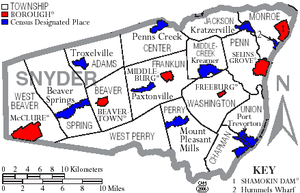
Paxtonville is a census-designated place
(CDP) in Snyder County
, Pennsylvania
, United States
. The population was 221 at the 2000 census.
According to the United States Census Bureau
, the CDP has a total area of 0.9 square miles (2.3 km²), all of it land.
of 2000, there were 221 people, 92 households, and 64 families residing in the CDP. The population density
was 234.9 people per square mile (90.8/km²). There were 97 housing units at an average density of 103.1/sq mi (39.8/km²). The racial makeup of the CDP was 100.00% White.
There were 92 households out of which 29.3% had children under the age of 18 living with them, 57.6% were married couples
living together, 7.6% had a female householder with no husband present, and 30.4% were non-families. 29.3% of all households were made up of individuals and 17.4% had someone living alone who was 65 years of age or older. The average household size was 2.40 and the average family size was 2.95.
In the CDP the population was spread out with 24.9% under the age of 18, 7.7% from 18 to 24, 25.8% from 25 to 44, 24.9% from 45 to 64, and 16.7% who were 65 years of age or older. The median age was 39 years. For every 100 females there were 95.6 males. For every 100 females age 18 and over, there were 93.0 males.
The median income for a household in the CDP was $37,917, and the median income for a family was $43,594. Males had a median income of $25,000 versus $21,932 for females. The per capita income
for the CDP was $14,376. About 4.6% of families and 4.9% of the population were below the poverty line, including 4.8% of those under the age of eighteen and 14.5% of those sixty five or over.
The village of Paxtonville lies on Middle Creek in Pennsylvania and is connected to Middleburg, Koonhunter and Beavertown by the Paxtonville Road. Settled in the late 18th century, it was first known as Kern's Mill, but was renamed after Robert Paxton. Just after the Civil War an iron furnace was built there, but it fell into disuse after a relatively short period of time when richer ores were found in the Great Lakes region. In the early years of the 20th century, brick-making was a major industry, but this ended in the summer of 1963 when fire destroyed the Paxton Brick Company. A water-powered sawmill and cider press were in operation about 1900. At various times businesses included a creamery, a restaurant, a cigar factory, a shirt factory, one or two general stores, a barbershop, a grist mill and a gunsmith. As of December 2007, the town boasts a church and a feed mill, as well as a community center. The building housing the community center was previously a two room school house in which instruction was provided for grades 1 through 8. Its last use for this purpose was in the Spring of 1955; after this time pupils were bussed to Middleburg. Around 1890 a school building stood on the north-east corner of Mill Street and the Paxtonville Road.
The soil underlying the village is principally glacial till, but about 150 feet west and 50 feet south of the juncture of the Paxtonville Road and Paxton Street sedimentary rock lies just beneath the soil surface. Stone American Indian artifacts, chiefly arrow and spear points, are to be found at the north edge of town near the bank of Middle Creek. The completion of the Sunbury and Lewistown Railroad in the 1870s connected Paxtonville with these two cities, and for many years a number of daily passenger trains stopped at the Paxtonville station, which was located near the creek. Passenger service ended in the late 1920s. For a short period of time, toward the end of the 19th century, Paxtonville was shown on railroad maps as Benfer. A number of the oldest houses are log, but this construction is not evident because they have frame or shingle siding; they date from the early 19th century. As of 2007 there stands on the north side of Maple Avenue, about 100 feet west of the intersection with Paxton Street, a house of unusual design. Built by Gabriel Gill about 1885, it lacks a frame, but the exterior walls serve this purpose, being constructed of three layers of one inch planks, with the middle layer running at a 90 degree angle to the other two.
Over the years most residents have been of Pennsylvania-Dutch ancestry, as witnessed by family names such as Walter, Gill, Straub and Musser. About 1900 the cemetery was moved from behind its position behind the church on the east edge of the village to its modern location on the south-west edge. Coffins and their contents were carried on horse-drawn wagons. Immediately after World War I donations from townspeople allowed the erection of the Memorial Hall on the west side of Paxton Street. It served a number of functions, including showing movies. During the era of silent films these were accompanied by the Paxtonville Orchestra.
Census-designated place
A census-designated place is a concentration of population identified by the United States Census Bureau for statistical purposes. CDPs are delineated for each decennial census as the statistical counterparts of incorporated places such as cities, towns and villages...
(CDP) in Snyder County
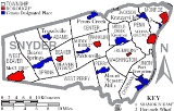
Snyder County, Pennsylvania
Snyder County is a county located in the U.S. state of Pennsylvania. As of 2010, the population was 39,702. Snyder County was formed in 1855 from parts of Union County...
, Pennsylvania
Pennsylvania
The Commonwealth of Pennsylvania is a U.S. state that is located in the Northeastern and Mid-Atlantic regions of the United States. The state borders Delaware and Maryland to the south, West Virginia to the southwest, Ohio to the west, New York and Ontario, Canada, to the north, and New Jersey to...
, United States
United States
The United States of America is a federal constitutional republic comprising fifty states and a federal district...
. The population was 221 at the 2000 census.
Geography
Paxtonville is located at 40°46′14"N 77°5′8"W (40.770448, -77.085661).According to the United States Census Bureau
United States Census Bureau
The United States Census Bureau is the government agency that is responsible for the United States Census. It also gathers other national demographic and economic data...
, the CDP has a total area of 0.9 square miles (2.3 km²), all of it land.
Demographics
As of the censusCensus
A census is the procedure of systematically acquiring and recording information about the members of a given population. It is a regularly occurring and official count of a particular population. The term is used mostly in connection with national population and housing censuses; other common...
of 2000, there were 221 people, 92 households, and 64 families residing in the CDP. The population density
Population density
Population density is a measurement of population per unit area or unit volume. It is frequently applied to living organisms, and particularly to humans...
was 234.9 people per square mile (90.8/km²). There were 97 housing units at an average density of 103.1/sq mi (39.8/km²). The racial makeup of the CDP was 100.00% White.
There were 92 households out of which 29.3% had children under the age of 18 living with them, 57.6% were married couples
Marriage
Marriage is a social union or legal contract between people that creates kinship. It is an institution in which interpersonal relationships, usually intimate and sexual, are acknowledged in a variety of ways, depending on the culture or subculture in which it is found...
living together, 7.6% had a female householder with no husband present, and 30.4% were non-families. 29.3% of all households were made up of individuals and 17.4% had someone living alone who was 65 years of age or older. The average household size was 2.40 and the average family size was 2.95.
In the CDP the population was spread out with 24.9% under the age of 18, 7.7% from 18 to 24, 25.8% from 25 to 44, 24.9% from 45 to 64, and 16.7% who were 65 years of age or older. The median age was 39 years. For every 100 females there were 95.6 males. For every 100 females age 18 and over, there were 93.0 males.
The median income for a household in the CDP was $37,917, and the median income for a family was $43,594. Males had a median income of $25,000 versus $21,932 for females. The per capita income
Per capita income
Per capita income or income per person is a measure of mean income within an economic aggregate, such as a country or city. It is calculated by taking a measure of all sources of income in the aggregate and dividing it by the total population...
for the CDP was $14,376. About 4.6% of families and 4.9% of the population were below the poverty line, including 4.8% of those under the age of eighteen and 14.5% of those sixty five or over.
The village of Paxtonville lies on Middle Creek in Pennsylvania and is connected to Middleburg, Koonhunter and Beavertown by the Paxtonville Road. Settled in the late 18th century, it was first known as Kern's Mill, but was renamed after Robert Paxton. Just after the Civil War an iron furnace was built there, but it fell into disuse after a relatively short period of time when richer ores were found in the Great Lakes region. In the early years of the 20th century, brick-making was a major industry, but this ended in the summer of 1963 when fire destroyed the Paxton Brick Company. A water-powered sawmill and cider press were in operation about 1900. At various times businesses included a creamery, a restaurant, a cigar factory, a shirt factory, one or two general stores, a barbershop, a grist mill and a gunsmith. As of December 2007, the town boasts a church and a feed mill, as well as a community center. The building housing the community center was previously a two room school house in which instruction was provided for grades 1 through 8. Its last use for this purpose was in the Spring of 1955; after this time pupils were bussed to Middleburg. Around 1890 a school building stood on the north-east corner of Mill Street and the Paxtonville Road.
The soil underlying the village is principally glacial till, but about 150 feet west and 50 feet south of the juncture of the Paxtonville Road and Paxton Street sedimentary rock lies just beneath the soil surface. Stone American Indian artifacts, chiefly arrow and spear points, are to be found at the north edge of town near the bank of Middle Creek. The completion of the Sunbury and Lewistown Railroad in the 1870s connected Paxtonville with these two cities, and for many years a number of daily passenger trains stopped at the Paxtonville station, which was located near the creek. Passenger service ended in the late 1920s. For a short period of time, toward the end of the 19th century, Paxtonville was shown on railroad maps as Benfer. A number of the oldest houses are log, but this construction is not evident because they have frame or shingle siding; they date from the early 19th century. As of 2007 there stands on the north side of Maple Avenue, about 100 feet west of the intersection with Paxton Street, a house of unusual design. Built by Gabriel Gill about 1885, it lacks a frame, but the exterior walls serve this purpose, being constructed of three layers of one inch planks, with the middle layer running at a 90 degree angle to the other two.
Over the years most residents have been of Pennsylvania-Dutch ancestry, as witnessed by family names such as Walter, Gill, Straub and Musser. About 1900 the cemetery was moved from behind its position behind the church on the east edge of the village to its modern location on the south-west edge. Coffins and their contents were carried on horse-drawn wagons. Immediately after World War I donations from townspeople allowed the erection of the Memorial Hall on the west side of Paxton Street. It served a number of functions, including showing movies. During the era of silent films these were accompanied by the Paxtonville Orchestra.