

Pathfinder March
Encyclopedia
Cambridgeshire
Cambridgeshire is a county in England, bordering Lincolnshire to the north, Norfolk to the northeast, Suffolk to the east, Essex and Hertfordshire to the south, and Bedfordshire and Northamptonshire to the west...
, England
England
England is a country that is part of the United Kingdom. It shares land borders with Scotland to the north and Wales to the west; the Irish Sea is to the north west, the Celtic Sea to the south west, with the North Sea to the east and the English Channel to the south separating it from continental...
. The March, which typically draws between three- and five hundred participants, is held to perpetuate the memory of the famous Royal Air Force
Royal Air Force
The Royal Air Force is the aerial warfare service branch of the British Armed Forces. Formed on 1 April 1918, it is the oldest independent air force in the world...
Pathfinder Force from the Second World War.
The event, starts and finishes at the Royal Air Force Wyton, and is scheduled for the closest Saturday to the Mid-Summers Day
Summer solstice
The summer solstice occurs exactly when the axial tilt of a planet's semi-axis in a given hemisphere is most inclined towards the star that it orbits. Earth's maximum axial tilt to our star, the Sun, during a solstice is 23° 26'. Though the summer solstice is an instant in time, the term is also...
. Due to the strenuous nature of this event, and the weather conditions a number of participants do not complete the course.
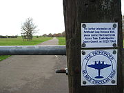
The route has been modified since the Pathfinder March was first introduced in 1997, and no longer crosses the airfield as it is active during the event. Instead, the route now tracks from Warboys west to the village of Kings Ripton, before heading south and the RAF station. The route is signposted with way marker signs displaying the silhouette of a mosquito aircraft and is open all year as the Pathfinder Long Distance Walk.
The route
Entrants have 20 hours to complete the full 46 mile course. Walkers set off at 0400 hrs, whilst those wishing to run the distance start at 0800 hrs to allow time for the check points to be put in place at later stages of the route. All participants are encouraged to keep to the times set for the various stages of the course, otherwise they will not complete the course and be forced to retire. The route encompasses RAF WytonRAF Wyton
RAF Wyton is a Royal Air Force station near St. Ives, Cambridgeshire, England.In terms of organisation RAF Wyton is now part of the combined station RAF Brampton Wyton Henlow, a merger of Wyton with two previously separate bases, RAF Brampton and RAF Henlow. Wyton is the largest of the three. It...
, Godmanchester
Godmanchester
Godmanchester is a small town and civil parish within the Huntingdonshire district of Cambridgeshire, in England. It lies on the south bank of the River Great Ouse, south of the larger town of Huntingdon, and on the A14 road....
, Graveley Airfield, Graveley, Papworth Everard
Papworth Everard
Papworth Everard is a village in Cambridgeshire, England. It lies ten miles west of Cambridge and six miles south of Huntingdon, having along its centre Ermine Street, the old North Road, the Roman highway that for centuries served as a major artery from London to York, which is now the A1198...
, Elsworth, Childerly, Dry Drayton
Dry Drayton
Dry Drayton is a village and civil parish about 5 miles northwest of Cambridge in Cambridgeshire, England. It covers an area of .-History:...
, Oakington
Oakington
Oakington is a small village 4 miles north-west of Cambridge in Cambridgeshire in England, and belongs to the administrative district of South Cambridgeshire. The village falls into the parish of Oakington and Westwick.-History:...
, Oakington Airfield, Longstanton, Bluntisham
Bluntisham
Bluntisham is a village in the Huntingdonshire district of Cambridgeshire), England. It is near Earith east of St Ives.The Prime Meridian passes through the western edge of Bluntisham.Also known as Bluntisham-cum-Earith...
, Colne, Somersham, Warboys
Warboys
Warboys is a village in Huntingdonshire , England, near Ramsey and north east of Huntingdon.-History:Warboys is a large parish and village on what was the eastern side of Huntingdonshire bordering on Cambridgeshire. It was returned in the Domesday survey of 1086 amongst the lands of St...
, Warboys Airfield, Kings Ripton
Kings Ripton
Kings Ripton is a village and civil parish in Huntingdonshire , England, and is located NNE of Huntingdon. The village is within the Upwood and The Raveleys ward of Huntingdonshire District Council...
before finishing back at RAF Wyton. There are 8 Check Points for participants to report to and have their walkers/runners cards punched.
A small section of the Ouse Valley Way
Ouse Valley Way
The Ouse Valley Way is a 150-mile footpath in England, following the River Great Ouse from its source near Brackley in Northamptonshire to its mouth in The Wash near King's Lynn...
is used on the Pathfinder March.
The 2011 event will take place on the 25th June. Entry is £10 / participant.