

Patcham
Encyclopedia

A27 road
The A27 is a major road in England. It runs from its junction with the A36 at Whiteparish in the county of Wiltshire. It closely parallels the south coast, where it passes through West Sussex and terminates at Pevensey in East Sussex.Between Portsmouth and Lewes, it is one of the busiest trunk...
(Brighton bypass) to the north, Hollingbury
Hollingbury
Hollingbury is an area of the city of Brighton and Hove, East Sussex. The area sits high on a hillside across the north of the city above Patcham which lies in a valley to the west, Coldean in a valley to the east, and the A27 bypass forming the northern limit...
to the east and southeast, Withdean
Withdean
Withdean is a former village, now part of Brighton and Hove, East Sussex. The area was originally named in the 12th century, when it was called Wictedene. The area was historically farm land but has been developed, mainly in the 1920s and 1930s, with a mix of detached, semi-detached and mid-rise...
to the south and the Brighton Main Line
Brighton Main Line
The Brighton Main Line is a British railway line from London Victoria and London Bridge to Brighton. It is about 50 miles long, and is electrified throughout. Trains are operated by Southern, First Capital Connect, and Gatwick Express, now part of Southern.-Original proposals:There were no fewer...
to the west. The A23
A23 road
The A23 road is a major road in the United Kingdom between London and Brighton, East Sussex. It became an arterial route following the construction of Westminster Bridge in 1750 and the consequent improvement of roads leading to the bridge south of the river by the Turnpike Trusts...
passes through the area.
History
Patcham was originally a separate village based around the partly 12th- and 13th-Century All Saints church. The parish of Patcham extended to 32 square miles (82.9 km²) and encompassed large parts of what are now adjacent suburbs, such as WithdeanWithdean
Withdean is a former village, now part of Brighton and Hove, East Sussex. The area was originally named in the 12th century, when it was called Wictedene. The area was historically farm land but has been developed, mainly in the 1920s and 1930s, with a mix of detached, semi-detached and mid-rise...
, Westdene
Westdene
Westdene is an area of the city of Brighton and Hove, East Sussex. It is a northern suburb of the city, west of Patcham, the A23 and the London to Brighton railway line, north of Withdean and northeast of West Blatchington. It is on the Brighton side of the historic parish boundary between...
, Hollingbury and Tongdean. It extended eastwards into modern-day Moulsecoomb
Moulsecoomb
Moulsecoomb is a large suburb of Brighton, part of the city of Brighton and Hove. It is located on the northeastern side of Brighton, around the A270 Lewes Road, between the areas of Coldean and Bevendean and approximately 2¼ miles north of the seafront. The eastern edges of the built-up area...
, westwards beyond Dyke Road into Hove
Hove
Hove is a town on the south coast of England, immediately to the west of its larger neighbour Brighton, with which it forms the unitary authority Brighton and Hove. It forms a single conurbation together with Brighton and some smaller towns and villages running along the coast...
, and northwards across the sparsely-populated South Downs
South Downs
The South Downs is a range of chalk hills that extends for about across the south-eastern coastal counties of England from the Itchen Valley of Hampshire in the west to Beachy Head, near Eastbourne, East Sussex, in the east. It is bounded on its northern side by a steep escarpment, from whose...
towards the parishes of Pyecombe
Pyecombe
Pyecombe is a village and civil parish in the Mid Sussex District of West Sussex, England. It is located 7 miles to the north of Brighton. The civil parish covers an area of and has a population of 200 ....
and Ditchling
Ditchling
Ditchling is a village and civil parish in the Lewes District of East Sussex, England. The village is contained within the boundaries of the South Downs National Park; the order confirming the establishment of the park was signed in Ditchling....
. The centre of the original village, based around the church (on Church Hill) and the Old London Road - now bypassed by the modern A23 - is a conservation area, and several buildings are listed.
Modern Patcham
Sir Herbert Carden, a prominent Brighton solicitor who served as Mayor for three years from 1916 and who served on the council from 1895 until 1941, was responsible for the boundary changes on 1 April 1928 which brought Patcham within the "Greater Brighton" area. To commemorate this, two large stone pillars, known as the "Pylons", were erected on the A23 just north of the village of Patcham, marking the new boundary line. http://www.mybrightonandhove.org.uk/page_id__5252.aspx The land around the village was mostly undeveloped at this time, which allowed substantial housebuilding work to commence. Many of the estates built around the old village date from the 1930s. The Ladies Mile Estate, built around the former Drove road from the village to Stanmer ParkStanmer Park
Stanmer Park is a large open park immediately to the west of the University of Sussex, and to the north-east of the town of Brighton in the county of East Sussex, England, UK....
, is one such example; it is separated from Hollingbury to the southeast by Carden Avenue, named after Sir Herbert.
The roads around the Mackie Avenue estate (all with Scottish names) were named by the Scottish builder George Ferguson who developed the estate. He also planted the Scots Pines on the Ladies Mile Open Space.
The Windmill View estate at the top of Ladies Mile Road is built on the site of the old Patcham Fawcett School.
Patcham Community Centre. The Patcham Community Centre is run by the Patcham Community Association, which was formed in 1945. There were originally 15 groups involved, including the Patcham Communist Party, and for the first 24 years they existed without their own centre, holding meetings in the school halls in the area. Fron .
In 1969 the Patcham Fawcett High School for Boys, situated at the top of Ladies Mile Road, and the Margaret Hardy High School for Girls, situated in Warmdene Road were relocated from central Brighton to Patcham. Fawcett had new buildings at the far end of Ladies Mile Road, while Margaret Hardy was housed in what had been the classrooms used by Patcham First School. Patcham First relocated to brand new buildings in Highview Avenue North.
At the same time Alderman Kippin (known as 'Mr Patcham') arranged for a combined Community Centre & Youth Club, each with their own suite of rooms with a shared kitchen, to be included in the basement of a new wing of Margaret Hardy.
The 1989 merger of Fawcett and Margaret Hardy into Patcham High brought the boys and girls together on Warmdene Road. As part of a need for extra space, in 2003 a PFI project overhauled the school buildings and a new Community Building erected just outside the High school grounds to incorporate both the Community Centre and the Community Library.
The new Centre is now a hub of activity for local people, with over 40 different organisations using it, in addition to hosting many family celebrations. Please visit the website for fuller details.
Places of interest in Patcham
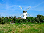
Waterhall Mill, Patcham
Waterhall Mill is a grade II listed tower mill at Patcham, Sussex, England which has been converted to residential use.-History:Waterhall Mill was built in 1885 by James Holloway, the Shoreham millwright. It was the last windmill built in Sussex, and was working until 1924. The mill was converted...
is a converted windmill
Windmill
A windmill is a machine which converts the energy of wind into rotational energy by means of vanes called sails or blades. Originally windmills were developed for milling grain for food production. In the course of history the windmill was adapted to many other industrial uses. An important...
on high ground west of the old village (but within the former Patcham parish). Also known as Waterhall Mill and locally as Westdene Mill, it was built in 1885 and was used for 40 years. A second mill, now demolished, stood on a site near Overhill Drive and is commemorated by the street name Old Mill Close.Patcham Mill website
Patcham Place
Patcham Place
Patcham Place is a mansion in the ancient village of Patcham, now part of the English city of Brighton and Hove. Built in 1558 as part of the Patcham Place estate, it was owned for many years by Anthony Stapley, one of the signatories of King Charles I's death warrant...
http://www.yha.org.uk/hostel/hostelpages/124.html (Photo) was the city's Youth Hostel until September 2007. It is located in the old village centre opposite the post office, in a large area of open parkland beneath which runs the Brighton Main Line through the 492 yards (449.9 m) Patcham Tunnel
Patcham Tunnel
Patcham tunnel is a railway tunnel on the Brighton Main Line through the South Downs between Preston Park and Hassocks in East Sussex, England. It is 488 yards long.-History:...
. The house dates from 1558 and was originally the seat of the Shelley family. It later belonged to the Stapley family - Anthony Stapley
Anthony Stapley
Anthony Stapley was one of the regicides of King Charles I of England.Stapley was M.P. for New Shoreham , Lewes , Sussex . He was colonel and governor of Chichester and signed the death-warrant of Charles I...
played a leading part in the Civil War, being Governor of Chichester and a Regicide.
All Saints Church
All Saints Church, Patcham
All Saints Church is the Anglican parish church of Patcham, an ancient Sussex village which is now part of the English city of Brighton and Hove. A place of worship has existed on the hilltop site for about 1,000 years, but the present building has Norman internal features and a 13th-century...
(website) is one of the city of Brighton and Hove's oldest churches, and is still a lively community of people. A church was recorded on this site in the Domesday Book
Domesday Book
Domesday Book , now held at The National Archives, Kew, Richmond upon Thames in South West London, is the record of the great survey of much of England and parts of Wales completed in 1086...
. The churchyard includes an interesting gravestone marked with a pirate skull and crossbones motif. Close to the church stands an ancient dovecot and converted tithe barn.
Transport
Brighton & Hove Bus and Coach CompanyBrighton & Hove Bus and Coach Company
Brighton & Hove Bus and Coach Company operates almost all bus services in the city of Brighton and Hove in southern England. The company was established in 1884 as Brighton, Hove and Preston United Omnibus Company and has been part of the Go-Ahead Group since 1993.The company currently operates a...
routes 5 and 5A (from Hangleton
Hangleton
Hangleton is an estate in west Hove, East Sussex. The estate was developed circa the late 1930s after the Dyke railway was closed.It contains both the oldest building in the city of Brighton and Hove, St Helen's Church, and the second oldest building: that which was Hangleton Manor and is now the...
via the city centre) undertake a circular tour of the eastern side of Patcham. Route 5A travels through the centre of the old village, while Route 5 deviates on to Carden Avenue. Both of these routes have a 20-minute daytime frequency. The hourly Route 56 starts in the village centre and passes through the Ladies Mile Estate en route to Hollingbury, the City Centre and the Knoll Estate
Hangleton
Hangleton is an estate in west Hove, East Sussex. The estate was developed circa the late 1930s after the Dyke railway was closed.It contains both the oldest building in the city of Brighton and Hove, St Helen's Church, and the second oldest building: that which was Hangleton Manor and is now the...
in Hove
Hove
Hove is a town on the south coast of England, immediately to the west of its larger neighbour Brighton, with which it forms the unitary authority Brighton and Hove. It forms a single conurbation together with Brighton and some smaller towns and villages running along the coast...
.
Some other services stop on the A23 outside the Black Lion pub near the Youth Hostel:
- Countryliner CoachesCountryliner CoachesCountryliner is a large independent bus and coach operator, based in Merrow, Surrey, England. It operates in Surrey, East Sussex and West Sussex, running a number of bus and private hire coach services...
route 40/40X (Brighton to CuckfieldCuckfieldCuckfield is a large village and civil parish in the Mid Sussex District of West Sussex, England, on the southern slopes of the Weald. It lies south of London, north of Brighton, and east northeast of the county town of Chichester. Nearby towns include Haywards Heath to the southeast and Burgess...
, Mondays to Saturdays) - MetrobusMetrobus (Go-Ahead Group)Metrobus is a bus operator with routes in south and south-east London, and parts of Surrey, Kent, West and East Sussex. The company operates many routes on tender from Transport for London. Formed through a management buyout of Tillingbourne Ltd...
route 273 (to CrawleyCrawleyCrawley is a town and local government district with Borough status in West Sussex, England. It is south of Charing Cross, north of Brighton and Hove, and northeast of the county town of Chichester, covers an area of and had a population of 99,744 at the time of the 2001 Census.The area has...
, Mondays to Saturdays) - Stagecoach (Mondays to Saturdays), Compass Travel (Sundays) route 17 to Horsham
After the second world war, Patcham was served by Brighton Hove & District Transport with bus routes 5 and 5b running jointly every 7 or 8 minutes from Brighton via the London Road to Carden Avenue, Winfield Avenue, The Ladies Mile (Clock Tower) and Mackie Avenue. Route 15 operated every 20 minutes from Brighton via the London Road to Carden Avenue, Winfield Avenue, The Ladies Mile (Clock Tower) and Barrhill Avenue to Braeside Avenue(The Deeside). Route 15b operated every 20 minutes from Brighton via London Road to Patcham Fountain, Patcham Old Village, Ladies Mile Road to The Ladies Mile (Clock Tower).