

Papaloapan Region, Oaxaca
Encyclopedia
The Cuenca del Papaloapan Region is in the north of the state of Oaxaca
, Mexico
where the foothills of the Sierra Madre de Oaxaca
meet the coastal plain of Veracruz
.
The principal city is San Juan Bautista Tuxtepec
, the second largest in Oaxaca state.
region and on the south by the Sierra Norte
region of Oaxaca. On the north it meets the state of Puebla
and to the west the state of Veracruz
.
The region has an area of 8,678 km2 with two districts, Choapan and Tuxtepec.
The climate is hot and humid all year, with average temperature 24°C to 26°C and average annual precipitation of 2,000mm to 4,500mm.
The Papaloapan region has diverse flora and lush vegetation, including amate, fig, locust, mahogany, oak, cedar, aloe, palm and ceiba hormiguillo. Fauna include porcupine, armadillo, jaguar, raccoon, gray fox, brocket deer and white-tailed deer. There is a great variety of birds.
The region today suffers from serious pollution in the Papaloapan river and an alarming increase in erosion due to livestock.
 As of the 2005 census, the region had a population of 429,681 inhabitants, or 49.51 inhabitants per square kilometer.
The population includes Chinatecs, Mazatec, Mixes
, Zapotecs and Mestizos, but the indigenous influence is not as visible in social and cultural life as in the other regions of Oaxaca.
Given its location in the coastal plain, the region tends to identify itself more with the state of Veracruz than Oaxaca.
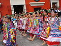
Before 1958, the region was represented in the Lunes del Cerro festival by the Fandango Jarocho.
The Governor Alfonso Perez Gasga then decided to replace the Fandango with a new dance that had a more typical Oaxacan nature, creating the "Flor de Piña" which would eventually represent the region.
It contains the major Cerro de Oro
and Miguel Alemán
dams, which play a central role in flood prevention in the Papaloapan River
basin in Veracruz, and are important sources of hydroelectric power.
Industries include small-scale manufacture of fine wood furniture, sugar mills, chemical plants, refrigeration, fruit packers, paper mills, ethanol distillery and brewery.
The region has deposits of oil, gold, uranium, coal and copper that have not yet been exploited.
With fertile, well-watered soil, pineapple is the primary crop, as well as rice, mango, litchi, banana, sugarcane, watermelon, green pepper, snuff, lemon, rubber, malanga and orange.
There are large areas of grassland used for grazing cattle, thoroughbred horses, pigs and poultry.
These are affecting soil fertility.
Fisheries catch sunfish, tilapia, and red tenhuayaca in the springs, dams and rivers.
The first major settlement was the town of Tuxtepec in the year 1811, and on March 15, 1825 it was declared a municipality.
During the war of independence
, it was the base of the Soyaltepec (Mazatecan
) rebels, and there was similar resistance during the Empire of Maximilian
.
In the late 1960s and early 1970s the federal government became interested in development of the economic potential of the Oaxacan region.
Governor Victor Bravo Ahuja
, originally from Tuxtepec, gave a strong impetus for development and modernization of the area, promoting agricultural, commercial and industrial development.
such as Zuzul, Los Cocos, Piedra Quemada and Los Sauces.
This area has an exquisite tropical climate with clear waters and lush forests inhabited by exotic birds such as toucans, macaws, parrots and pelicans.
Ecotourism is the most important tourist activity, the region having numerous streams, caves, swamps and lagoons of sulphurous waters, providing opportunities for forest mountain hiking, horseback riding through the jungle and cave exploration.
Oaxaca
Oaxaca , , officially Estado Libre y Soberano de Oaxaca is one of the 31 states which, along with the Federal District, comprise the 32 federative entities of Mexico. It is divided into 571 municipalities; of which 418 are governed by the system of customs and traditions...
, Mexico
Mexico
The United Mexican States , commonly known as Mexico , is a federal constitutional republic in North America. It is bordered on the north by the United States; on the south and west by the Pacific Ocean; on the southeast by Guatemala, Belize, and the Caribbean Sea; and on the east by the Gulf of...
where the foothills of the Sierra Madre de Oaxaca
Sierra Madre de Oaxaca
The Sierra Madre de Oaxaca is a mountain range in southern Mexico. It begins at Pico de Orizaba and extends in a southeasterly direction for 300 km until reaching the Isthmus of Tehuantepec...
meet the coastal plain of Veracruz
Veracruz
Veracruz, formally Veracruz de Ignacio de la Llave officially Estado Libre y Soberano de Veracruz de Ignacio de la Llave , is one of the 31 states that, along with the Federal District, comprise the 32 federative entities of Mexico. It is divided in 212 municipalities and its capital city is...
.
The principal city is San Juan Bautista Tuxtepec
San Juan Bautista Tuxtepec
San Juan Bautista Tuxtepec , or simply referred to as Tuxtepec, is the head of the municipality by the same name and is the second most populous city of the Mexican state of Oaxaca....
, the second largest in Oaxaca state.
Geography
The region is bordered on the east by the CañadaCañada, Oaxaca
Cañada is a region in the state of Oaxaca, Mexico covering 4,300 square km. It includes two districts, Teotitlán and Cuicatlán.The main administrative center is Teotitlan de Flores Magon, but Huautla de Jimenez is considered the most important cultural center in the region.The region is named after...
region and on the south by the Sierra Norte
Sierra Norte de Oaxaca
La Sierra Norte de Oaxaca is a heavily-wooded region in the state of Oaxaca, Mexico.It is 62 km from the city of Oaxaca on Federal highway 175, heading east towards Tuxtepec....
region of Oaxaca. On the north it meets the state of Puebla
Puebla
Puebla officially Estado Libre y Soberano de Puebla is one of the 31 states which, with the Federal District, comprise the 32 Federal Entities of Mexico. It is divided in 217 municipalities and its capital city is Puebla....
and to the west the state of Veracruz
Veracruz
Veracruz, formally Veracruz de Ignacio de la Llave officially Estado Libre y Soberano de Veracruz de Ignacio de la Llave , is one of the 31 states that, along with the Federal District, comprise the 32 federative entities of Mexico. It is divided in 212 municipalities and its capital city is...
.
The region has an area of 8,678 km2 with two districts, Choapan and Tuxtepec.
The climate is hot and humid all year, with average temperature 24°C to 26°C and average annual precipitation of 2,000mm to 4,500mm.
The Papaloapan region has diverse flora and lush vegetation, including amate, fig, locust, mahogany, oak, cedar, aloe, palm and ceiba hormiguillo. Fauna include porcupine, armadillo, jaguar, raccoon, gray fox, brocket deer and white-tailed deer. There is a great variety of birds.
The region today suffers from serious pollution in the Papaloapan river and an alarming increase in erosion due to livestock.
Population
The population includes Chinatecs, Mazatec, Mixes
Mixes
Mixes is a remix album by Australian pop–dance singer Kylie Minogue. It was released by Deconstruction Records on 3 August 1998 in the United Kingdom. First released as a special edition vinyl album, it was later released as a double-CD album due to the high demand from Minogue's fans...
, Zapotecs and Mestizos, but the indigenous influence is not as visible in social and cultural life as in the other regions of Oaxaca.
Given its location in the coastal plain, the region tends to identify itself more with the state of Veracruz than Oaxaca.
Before 1958, the region was represented in the Lunes del Cerro festival by the Fandango Jarocho.
The Governor Alfonso Perez Gasga then decided to replace the Fandango with a new dance that had a more typical Oaxacan nature, creating the "Flor de Piña" which would eventually represent the region.
Economy
The region is economically the most active and industrialized in the state.It contains the major Cerro de Oro
Cerro de Oro Dam
The Cerro de Oro Dam , also called the Miguel de la Madrid Hurtado Dam, is on the Santo Domingo River in the San Juan Bautista Tuxtepec municipality of the Papaloapan Region of Oaxaca state in southern Mexico....
and Miguel Alemán
Miguel Alemán Dam
The Miguel Alemán Dam is on the Tonto River in the Papaloapan Region of Oaxaca state in southern Mexico, just upstream from the town of Temascal or Nuevo Soyaltepec, forming the Miguel Alemán Lake with an area of 47,800 hectares....
dams, which play a central role in flood prevention in the Papaloapan River
Papaloapan River
The Papaloapan River is one of the main rivers of the Mexican state of Veracruz. Its name is derived from the Nahuatl papalotl and apan ....
basin in Veracruz, and are important sources of hydroelectric power.
Industries include small-scale manufacture of fine wood furniture, sugar mills, chemical plants, refrigeration, fruit packers, paper mills, ethanol distillery and brewery.
The region has deposits of oil, gold, uranium, coal and copper that have not yet been exploited.
With fertile, well-watered soil, pineapple is the primary crop, as well as rice, mango, litchi, banana, sugarcane, watermelon, green pepper, snuff, lemon, rubber, malanga and orange.
There are large areas of grassland used for grazing cattle, thoroughbred horses, pigs and poultry.
These are affecting soil fertility.
Fisheries catch sunfish, tilapia, and red tenhuayaca in the springs, dams and rivers.
History
The region first had contact with Spanish conquistadors who arrived seeking rivers of gold.The first major settlement was the town of Tuxtepec in the year 1811, and on March 15, 1825 it was declared a municipality.
During the war of independence
Mexican War of Independence
The Mexican War of Independence was an armed conflict between the people of Mexico and the Spanish colonial authorities which started on 16 September 1810. The movement, which became known as the Mexican War of Independence, was led by Mexican-born Spaniards, Mestizos and Amerindians who sought...
, it was the base of the Soyaltepec (Mazatecan
Mazatecan languages
The Mazatecan languages are a group of closely related indigenous languages spoken by some 200,000 people in the area known as La Sierra Mazateca, which located in the Northern part of the state of Oaxaca in southern Mexico, as well as in adjacent areas of the states of Puebla and Veracruz...
) rebels, and there was similar resistance during the Empire of Maximilian
Maximilian I of Mexico
Maximilian I was the only monarch of the Second Mexican Empire.After a distinguished career in the Austrian Navy, he was proclaimed Emperor of Mexico on April 10, 1864, with the backing of Napoleon III of France and a group of Mexican monarchists who sought to revive the Mexican monarchy...
.
In the late 1960s and early 1970s the federal government became interested in development of the economic potential of the Oaxacan region.
Governor Victor Bravo Ahuja
Víctor Bravo Ahuja
Víctor Bravo Ahuja was a Mexican politician and academician who served as Secretary of Public Education in the administration of Luis Echeverría , as Governor of Oaxaca and as Director General and then Rector of the Monterrey Institute of Technology .He was born into a family composed by...
, originally from Tuxtepec, gave a strong impetus for development and modernization of the area, promoting agricultural, commercial and industrial development.
Tourist attractions
The region has many spas, with most attractions in the tributaries of the Valle Nacional RiverValle Nacional River
The Valle Nacional River is a river of Oaxaca state in Mexico.The river originates in the Sierra Juárez, Oaxaca.The ecology of the region, originally one of pine forests, is threatened by logging, agriculture and grazing....
such as Zuzul, Los Cocos, Piedra Quemada and Los Sauces.
This area has an exquisite tropical climate with clear waters and lush forests inhabited by exotic birds such as toucans, macaws, parrots and pelicans.
Ecotourism is the most important tourist activity, the region having numerous streams, caves, swamps and lagoons of sulphurous waters, providing opportunities for forest mountain hiking, horseback riding through the jungle and cave exploration.
External links
- http://www.oeidrus-oaxaca.gob.mx/fichas/tomoI/distrito06.pdf
- http://www.oeidrus-oaxaca.gob.mx/fichas/tomoI/distrito07.pdf