

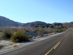
Panamint Springs, California
Encyclopedia

Unincorporated area
In law, an unincorporated area is a region of land that is not a part of any municipality.To "incorporate" in this context means to form a municipal corporation, a city, town, or village with its own government. An unincorporated community is usually not subject to or taxed by a municipal government...
in Inyo County
Inyo County, California
-National protected areas:* Death Valley National Park * Inyo National Forest * Manzanar National Historic Site-Major highways:* U.S. Route 6* U.S. Route 395* State Route 127* State Route 136* State Route 168* State Route 178...
, California
California
California is a state located on the West Coast of the United States. It is by far the most populous U.S. state, and the third-largest by land area...
. It lies at an elevation of 1926 feet (587 m).
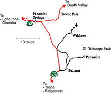
Panamint Springs is located along State Route 190 (SR190)
California State Route 190
State Route 190 is a state highway in the U.S. state of California that is split into two parts by the Sierra Nevada. The western portion of begins at Tipton at a junction with State Route 99 and heads east towards Porterville before ending at Quaking Aspen in the Sequoia National Forest...
between Old Toll Road and SR178/Panamint Valley Road
California State Route 178
State Route 178 is a route that exists in two constructed segments. The gap in between segments is connected by various local roads and State Route 190 through Death Valley National Park....
. The community features a motel, restaurant, and the last gas station for many miles in either direction on SR190.
Although not official by the Board of Geographic Names, Caltrans calls the SR178/SR190 intersection, Panamint Junction. The junction is about 2.5 driving miles east of Panamint Springs. Towne Pass, a landmark when traveling to Death Valley
Death Valley
Death Valley is a desert valley located in Eastern California. Situated within the Mojave Desert, it features the lowest, driest, and hottest locations in North America. Badwater, a basin located in Death Valley, is the specific location of the lowest elevation in North America at 282 feet below...
, is 13.9 driving miles east on SR190. Beyond the pass, SR190 descends about 5000 feet (1,524 m) to the dry bed of Lake Manly
Lake Manly
Lake Manly is a pluvial, former freshwater, endorheic, rift lake that filled the Death Valley basin of Inyo County, California through the Holocene before the area's climate changed to desert. Following its isolation from the Colorado River system, Lake Manly receded by evaporation with Badwater...
.
The Darwin Falls Wilderness
Darwin Falls Wilderness
The Darwin Falls Wilderness is a wilderness area in the northern Mojave Desert, and part of the National Wilderness Preservation System established by the California Desert Protection Act and managed by the Bureau of Land Management...
, a U.S. Wilderness Area, is located just west of the settlement. The nearby area also features the Darwin Falls
Darwin Falls
Darwin Falls is a waterfall located on the western edge of Death Valley National Park near the settlement of Panamint Springs, California. Although there exists a similarly named Darwin Falls Wilderness adjacent to the falls, the falls themselves are located in and administered by Death Valley...
, a small but scenic waterfall, grotto and creek that are the only year-round water supply in the driest part of North America; despite the similarly named wilderness, the falls are located in and administered by Death Valley National Park
Death Valley National Park
Death Valley National Park is a national park in the U.S. states of California and Nevada located east of the Sierra Nevada in the arid Great Basin of the United States. The park protects the northwest corner of the Mojave Desert and contains a diverse desert environment of salt-flats, sand dunes,...
. The dirt road entryway to the trail to Darwin Falls is located ¼ mile west of the settlement.
NAD27 latitude and longitude for Panamint Springs are 36°20′23"N 117°28′04"W and the feature ID number is 1661186. The elevation is identified as being 1940 feet (591.3 m) AMSL. The ZIP Code is 93545. The community is inside area code 760
Area code 760
Image:Area_code_442.svg|right|Map of California area codes in blue with 442/760 in redrect 65 82 92 100 Area code 916rect 220 242 245 256 Area code 909rect 243 274 265 287 Area code 951rect 136 323 160 338 Area code 858...
.
Similar name
The similar-sounding ghost town Panamint, California, also known as Panamint City, is located in Surprise Canyon about 25.8 miles (41.5 km) at 127.1 degrees off true north.Politics
In the state legislatureCalifornia State Legislature
The California State Legislature is the state legislature of the U.S. state of California. It is a bicameral body consisting of the lower house, the California State Assembly, with 80 members, and the upper house, the California State Senate, with 40 members...
Panamint Springs is located in the 18th Senate
California State Senate
The California State Senate is the upper house of the California State Legislature. There are 40 state senators. The state legislature meets in the California State Capitol in Sacramento. The Lieutenant Governor is the ex officio President of the Senate and may break a tied vote...
District, represented by Republican
Republican Party (United States)
The Republican Party is one of the two major contemporary political parties in the United States, along with the Democratic Party. Founded by anti-slavery expansion activists in 1854, it is often called the GOP . The party's platform generally reflects American conservatism in the U.S...
Roy Ashburn
Roy Ashburn
Roy Arthur Ashburn is an American politician from Kern County, California. A Republican, he served as a California State Senator from 2002 to 2010 representing the 18th district. He previously served three terms in the California State Assembly, representing the 32nd district and 12 years on the...
, and in the 18th Assembly
California State Assembly
The California State Assembly is the lower house of the California State Legislature. There are 80 members in the Assembly, representing an approximately equal number of constituents, with each district having a population of at least 420,000...
District, represented by Republican Bill Maze
Bill Maze
Bill Maze is an American politician from California and a member of the Republican Party. Maze is the president of Citizens for Saving California Farming Industries, a non-profit dedicated to dividing California into two states....
. Federally, Panamint Springs is located in California's 25th congressional district
California's 25th congressional district
California's 25th congressional district is a congressional district in the U.S. state of California that covers part of Los Angeles County and extends out to broad stretches of interior California along the Nevada border. It includes the cities of Santa Clarita, Palmdale, Lancaster, and the...
, which has a Cook PVI
Cook Partisan Voting Index
The Cook Partisan Voting Index , sometimes referred to as simply the Partisan Voting Index , is a measurement of how strongly an American congressional district or state leans toward one political party compared to the nation as a whole...
of R +7 and is represented by Republican Buck McKeon
Howard McKeon
Howard Philip "Buck" McKeon is the U.S. Representative for , serving since 1993. He is a member of the Republican Party.-Early life, education and career:...
.
Nearby
- Darwin, CaliforniaDarwin, CaliforniaDarwin is a census-designated place in Inyo County, California, United States. Darwin is located southeast of Keeler, at an elevation of 4790 feet . The population was 43 at the 2010 census, down from 54 at the 2000 census. It is named after Dr...
- Keeler, CaliforniaKeeler, CaliforniaKeeler is a census-designated place in Inyo County, California, United States. Keeler is located on the east shore of Owens Lake south-southeast of New York Butte, at an elevation of 3602 feet...
- Panamint ValleyPanamint ValleyThe Panamint Valley is a long basin located east of the Argus Range and Slate Range, and west of the Panamint Range in the northeastern reach of the Mojave Desert, in eastern California, United States.-Geography:...
- Panamint RangePanamint RangeThe Panamint Range is a short rugged fault-block mountain range on the northern edge of the Mojave Desert, in Death Valley National Park, Inyo County, California, United States.-Geography:...