

Panamint City, California
Encyclopedia
Ghost town
A ghost town is an abandoned town or city. A town often becomes a ghost town because the economic activity that supported it has failed, or due to natural or human-caused disasters such as floods, government actions, uncontrolled lawlessness, war, or nuclear disasters...
in the Panamint Range
Panamint Range
The Panamint Range is a short rugged fault-block mountain range on the northern edge of the Mojave Desert, in Death Valley National Park, Inyo County, California, United States.-Geography:...
, near Death Valley
Death Valley
Death Valley is a desert valley located in Eastern California. Situated within the Mojave Desert, it features the lowest, driest, and hottest locations in North America. Badwater, a basin located in Death Valley, is the specific location of the lowest elevation in North America at 282 feet below...
, in Inyo County, California
Inyo County, California
-National protected areas:* Death Valley National Park * Inyo National Forest * Manzanar National Historic Site-Major highways:* U.S. Route 6* U.S. Route 395* State Route 127* State Route 136* State Route 168* State Route 178...
, USA. It is also known by the official Board of Geographic Names identity, Panamint. Panamint was a boom town founded after silver
Silver
Silver is a metallic chemical element with the chemical symbol Ag and atomic number 47. A soft, white, lustrous transition metal, it has the highest electrical conductivity of any element and the highest thermal conductivity of any metal...
and copper were found there in 1872. By 1874, the town had a population of about 2,000. Its main street was one mile (1.6 km) long. Panamint had its own newspaper, the Panamint News. Silver was the principal product mined in the area. The town is located about three miles northwest of Sentinel Peak
Sentinel Peak
Sentinel Peak may refer to:* Sentinel Peak * Sentinel Peak * Sentinel Peak * Sentinel Peak * Sentinel Peak * Sentinel Peak * Sentinel Peak...
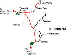
. According to the National Geographic Names Database, NAD27 latitude and longitude for the locale are 36°07′06"N 117°05′43"W and the feature ID number is 1661185. The elevation of this location is identified as being 6,280 feet AMSL. The similar-sounding Panamint Springs, California
Panamint Springs, California
Panamint Springs is an unincorporated community in Inyo County, California. It lies at an elevation of 1926 feet .Panamint Springs is located along State Route 190 between Old Toll Road and SR178/Panamint Valley Road...
, is located about 25.8 miles at 306.4 degrees off true north near Panamint Junction.
History
Panamint City is the site of the largest and most elaborate group of Coso Painted Style pictographsPictogram
A pictograph, also called pictogram or pictogramme is an ideogram that conveys its meaning through its pictorial resemblance to a physical object. Pictographs are often used in writing and graphic systems in which the characters are to considerable extent pictorial in appearance.Pictography is a...
. The presence of these pictographs indicates that Surprise Canyon was inhabited by Shoshone
Shoshone
The Shoshone or Shoshoni are a Native American tribe in the United States with three large divisions: the Northern, the Western and the Eastern....
and/or Kawaiisu
Kawaiisu
thumb|Kawaiisu FamilyThe Kawaiisu are a Native American group who lived in the southern California Tehachapi Valley and across the Tehachapi Pass in the southern Sierra Nevada Mountains to the north, toward Lake Isabella and Walker Pass...
not long before the town was founded.
Silver was discovered by William L. Kennedy, Robert L. Stewart, and Richard C. Jacobs, bandits who were using Surprise Canyon as a hideout. E. P. Raines, an early investor in Panamint mining, convinced a group of Los Angeles
Los Angeles, California
Los Angeles , with a population at the 2010 United States Census of 3,792,621, is the most populous city in California, USA and the second most populous in the United States, after New York City. It has an area of , and is located in Southern California...
businessmen to build a wagon road and then moved on to San Francisco
San Francisco, California
San Francisco , officially the City and County of San Francisco, is the financial, cultural, and transportation center of the San Francisco Bay Area, a region of 7.15 million people which includes San Jose and Oakland...
, where he met Nevada Senator John P. Jones
John P. Jones
John Percival Jones was an American politician who served for 30 years as a Republican United States Senator from Nevada. He made a fortune in silver mining and was a co-founder of the town of Santa Monica, California....
. Jones and the other Nevada Senator, William M. Stewart
William M. Stewart
William Morris Stewart was an American lawyer and politician.-Biography:Stewart was born in Wayne County, New York. As a child he moved with his parents to Trumbull County, Ohio. As a young man he was a mathematics teacher in Ohio. In 1849 he began attending Yale University but left in 1850 to...
, created the Panamint Mining Company and bought up the larger mines. The two were quite famous for their heavy involvement in silver mining in Nevada, and their interest in Panamint started the boom.
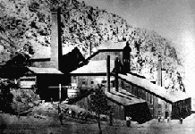
Founded in 1873-74, the town grew to include many mills
Factory
A factory or manufacturing plant is an industrial building where laborers manufacture goods or supervise machines processing one product into another. Most modern factories have large warehouses or warehouse-like facilities that contain heavy equipment used for assembly line production...
, saloons
Bar (establishment)
A bar is a business establishment that serves alcoholic drinks — beer, wine, liquor, and cocktails — for consumption on the premises.Bars provide stools or chairs that are placed at tables or counters for their patrons. Some bars have entertainment on a stage, such as a live band, comedians, go-go...
, stores, a red light district
Red-light district
A red-light district is a part of an urban area where there is a concentration of prostitution and sex-oriented businesses, such as sex shops, strip clubs, adult theaters, etc...
, a cemetery—all built along the uppermost end of Surprise Canyon. Panamint City was regarded as a "bad and wicked" town, with Death Valley at one end of town and the Panamint Range at the other end. Because of Panamint City's lawless reputation, Wells Fargo refused to open an office there. The senators solved the question of how to transport the silver bullion from the mines by casting it into 450-pound cannonballs, which were hauled to Los Angeles in an unguarded wagon.
On July 24, 1876, a flash flood roared down the canyon and washed out most of the town. The County of Inyo
Inyo County, California
-National protected areas:* Death Valley National Park * Inyo National Forest * Manzanar National Historic Site-Major highways:* U.S. Route 6* U.S. Route 395* State Route 127* State Route 136* State Route 168* State Route 178...
maintained a graded road to Panamint City until about 1983, when a terrific series of cloudbursts completely washed the canyon out to bedrock. This road permitted large vehicles such as house trailers and trucks with mining equipment to access Panamint City (some of these vehicles are abandoned there).
A post office operated at Panamint from 1874 to 1877, from 1882 to 1883, and from 1887 to 1895.
Panamint City and much of Surprise Canyon were added to Death Valley National Park
Death Valley National Park
Death Valley National Park is a national park in the U.S. states of California and Nevada located east of the Sierra Nevada in the arid Great Basin of the United States. The park protects the northwest corner of the Mojave Desert and contains a diverse desert environment of salt-flats, sand dunes,...
in 1994. Today, Panamint City is accessible only by a 7.5 mile hike, strenuous for even experienced hikers.
Nearby features
- Sentinel Peak is plotted on the 1988, Panamint, California topographic map at NAD83 latitude and longitude 36°05′47"N 117°04′39"W.
- Thompson Camp is plotted near NAD83 latitude and longitude 36°07′15"N 117°05′19"W on the 1988, Panamint, California topographic map.
- Hemlock Mine is plotted on the 1988, Panamint, California topographic map at NAD83 latitude and longitude 36°06′08"N 117°05′50"W.