
Palmerston Highway
Encyclopedia
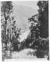
The Palmerston Highway serves as a link between the southern limit of the Atherton Tableland
s and the Far North Queensland
coastal strip, in Australia
. Starting just north of Innisfail
, from the Bruce Highway
it winds through the Wooroonooran National Park
, past the township of Millaa Millaa
and terminates where it meets the Kennedy Highway
north of Ravenshoe
. Its total length is 75 kilometres.
Atherton Tableland
The Atherton Tableland is a fertile plateau which is part of the Great Dividing Range in Queensland, Australia. It is located west to south-south-west inland from Cairns, well into the tropics, but its elevated position provides a climate suitable for dairy farming. It has an area of around...
s and the Far North Queensland
Far North Queensland
Far North Queensland, or FNQ, is the northernmost part of the Australian state of Queensland. The region, which contains a large section of the Tropical North Queensland area, stretches from the city of Cairns north to the Torres Strait...
coastal strip, in Australia
Australia
Australia , officially the Commonwealth of Australia, is a country in the Southern Hemisphere comprising the mainland of the Australian continent, the island of Tasmania, and numerous smaller islands in the Indian and Pacific Oceans. It is the world's sixth-largest country by total area...
. Starting just north of Innisfail
Innisfail, Queensland
Innisfail is a town located in the far north of the state of Queensland, Australia. It is the major township of the Cassowary Coast and is well renowned for its sugar and banana industries, as well as for being one of Australia's wettest towns...
, from the Bruce Highway
Bruce Highway
The Bruce Highway is a major highway in Queensland, Australia. Commencing in the state capital, Brisbane, it passes through areas close to the eastern coast to Cairns in Far North Queensland. The route is a part of the Australian National Highway and also part of Highway 1...
it winds through the Wooroonooran National Park
Wooroonooran National Park
Wooroonooran is a national park in Queensland , 1367 km northwest of Brisbane, between Innisfail and Cairns.The park is one of the Wet Tropics World Heritage Area series of national parks, and is a gazetted World Heritage site...
, past the township of Millaa Millaa
Millaa Millaa, Queensland
Millaa Millaa is a small town on the Atherton Tableland in Far North Queensland, Australia with a population of 295. It is located approximately 60 km west of cyclone-stricken Innisfail, north of Ravenshoe, south of Malanda...
and terminates where it meets the Kennedy Highway
Kennedy Highway
The Kennedy Highway is a highway in northern Queensland, Australia. It runs for approximately 250 km from Smithfield, on the northern outskirts of Cairns, to the Gulf Development Road in the vicinity of Forty Mile Scrub and Undara Volcanic national parks, about 40 kilometres south of Mount...
north of Ravenshoe
Ravenshoe, Queensland
Ravenshoe is a town on the Atherton Tableland in Far North Queensland, Australia. It is located south west of the regional centre, Cairns. At the 2006 census, Ravenshoe had a population of 910....
. Its total length is 75 kilometres.
See also
- Highways in AustraliaHighways in AustraliaThis is a list of highways in Australia, listed alphabetically along with each highway's route number and location. Note that some highways service more than one state or territory.-Route numbering systems:...
- List of highways in Queensland