
Paddy Buckley Round
Encyclopedia
The Paddy Buckley Round is a long distance fell running
challenge in Snowdonia
, Wales
. The route is a circuit of just over 100 km long taking in some 47 summits. The aim is for participants to complete the route, on foot. Although no time limit is set, an arbitrary 24 hours is applied, similar to the Bob Graham Round
. Runners may start at any point on the circular route (finishing at the same place) and may run the course in either a clockwise or anticlockwise direction. The route takes in the well known high mountain ranges of Snowdon
, the Glyderau
and the Carneddau
as well as the slightly less well visited ranges of Moel Siabod
, the Moelwynion
, Moel Hebog
and the Nantlle Ridge
. The route was devised by the eponymous Paddy Buckley and first completed in 1982.
The fastest known completion of the Round was, for many years, by Mark Hartell in 18 hours 10 minutes. On 4 May 2008, this time was matched by Chris Near of Eryri Harriers. Finally, this old record was broken by Tim Higginbottom in July 2009 to set a new record at 17 hours and 42 minutes.
The Round has the reputation of being somewhat tougher to complete than its English Lake District
equivalent, the Bob Graham Round
. Certainly, far fewer runners have completed the Paddy Buckley; however, relatively few have actually attempted it. The selection of summits that must be visited is somewhat arbitrary and no rules appear to have been applied in selecting them. Generally, it takes in the major peaks of the ranges that are being crossed, then any minor tops that are passed along the way are also included. Some of these tops really are just bumps on the ridge and not really summits in their own right at all.
In their book, "The Welsh Three Thousand Foot Challenges: A Guide for Walkers and Hill Runners" , Ronald Turnbull and Roy Clayton describe the route and also suggest attempting it as a four day backpacking (lightweight camping) excursion.
.
Fell running
Fell running, also known as mountain running and hill running, is the sport of running and racing, off road, over upland country where the gradient climbed is a significant component of the difficulty...
challenge in Snowdonia
Snowdonia
Snowdonia is a region in north Wales and a national park of in area. It was the first to be designated of the three National Parks in Wales, in 1951.-Name and extent:...
, Wales
Wales
Wales is a country that is part of the United Kingdom and the island of Great Britain, bordered by England to its east and the Atlantic Ocean and Irish Sea to its west. It has a population of three million, and a total area of 20,779 km²...
. The route is a circuit of just over 100 km long taking in some 47 summits. The aim is for participants to complete the route, on foot. Although no time limit is set, an arbitrary 24 hours is applied, similar to the Bob Graham Round
Bob Graham Round
The Bob Graham Round is a circuit of 42 fells in the English Lake District, including the peaks of Skiddaw, Helvellyn, Scafell and Scafell Pike...
. Runners may start at any point on the circular route (finishing at the same place) and may run the course in either a clockwise or anticlockwise direction. The route takes in the well known high mountain ranges of Snowdon
Snowdon Massif
The Snowdon Massif is one of the three mountain groups in Snowdonia, north Wales, to include mountains over 3,000 feet high. It occupies the area between Beddgelert, Pen-y-Pass and Llanberis...
, the Glyderau
Glyderau
The Glyderau are a mountain group in Snowdonia, North Wales. The name derives from the highest peaks in the range, Glyder Fawr and Glyder Fach....
and the Carneddau
Carneddau
The Carneddau , are a group of mountains in Snowdonia, Wales. It includes the largest contiguous areas of high ground in Wales and England, as well as six or seven of the highest peaks in the country—the Fourteen Peaks...
as well as the slightly less well visited ranges of Moel Siabod
Moel Siabod
Moel Siabod is a mountain in Snowdonia, North Wales, which sits isolated above the villages of Betws-y-Coed and Capel Curig. At 872m it is the highest peak in the Moelwynion mountain range. The UK National Mountain Centre, Plas-y-Brenin, is located at the foot of Moel Siabod...
, the Moelwynion
Moelwynion
The Moelwynion are a group of mountains in central Snowdonia. They extend from the north-east of Porthmadog to Moel Siabod, the highest of the group...
, Moel Hebog
Moel Hebog
Moel Hebog is a mountain in Snowdonia, north Wales which dominates the view west from the village of Beddgelert...
and the Nantlle Ridge
Nantlle Ridge
The Nantlle Ridge is the name given to a small range of mountains in Snowdonia, north Wales which runs south-west from the village of Rhyd Ddu for a distance of about , ending above Talysarn and Nebo in the Nantlle Valley....
. The route was devised by the eponymous Paddy Buckley and first completed in 1982.
The fastest known completion of the Round was, for many years, by Mark Hartell in 18 hours 10 minutes. On 4 May 2008, this time was matched by Chris Near of Eryri Harriers. Finally, this old record was broken by Tim Higginbottom in July 2009 to set a new record at 17 hours and 42 minutes.
The Round has the reputation of being somewhat tougher to complete than its English Lake District
Lake District
The Lake District, also commonly known as The Lakes or Lakeland, is a mountainous region in North West England. A popular holiday destination, it is famous not only for its lakes and its mountains but also for its associations with the early 19th century poetry and writings of William Wordsworth...
equivalent, the Bob Graham Round
Bob Graham Round
The Bob Graham Round is a circuit of 42 fells in the English Lake District, including the peaks of Skiddaw, Helvellyn, Scafell and Scafell Pike...
. Certainly, far fewer runners have completed the Paddy Buckley; however, relatively few have actually attempted it. The selection of summits that must be visited is somewhat arbitrary and no rules appear to have been applied in selecting them. Generally, it takes in the major peaks of the ranges that are being crossed, then any minor tops that are passed along the way are also included. Some of these tops really are just bumps on the ridge and not really summits in their own right at all.
In their book, "The Welsh Three Thousand Foot Challenges: A Guide for Walkers and Hill Runners" , Ronald Turnbull and Roy Clayton describe the route and also suggest attempting it as a four day backpacking (lightweight camping) excursion.
Route
Below is a list of the summits that must be visited, in a clockwise direction, if starting from LlanberisLlanberis
Llanberis is a village in Gwynedd, North Wales, lying on the southern banks of Llyn Padarn in Snowdonia. It takes its name from Saint Peris, an early Welsh saint.According to the United Kingdom Census 2001, the population of Llanberis was 1,954...
.
| Summit | Grid reference | Altitude/m | Approximate cumulative distance/km | |
|---|---|---|---|---|
| Llanberis Llanberis Llanberis is a village in Gwynedd, North Wales, lying on the southern banks of Llyn Padarn in Snowdonia. It takes its name from Saint Peris, an early Welsh saint.According to the United Kingdom Census 2001, the population of Llanberis was 1,954... |
SH582598 | 105 | 0 | |
| 1 | Elidir Fach | SH603613 | 795 | 3 |
| 2 | Elidir Fawr Elidir Fawr Elidir Fawr is a mountain in Snowdonia, north Wales, the northernmost in the Glyderau. To the north of the summit is a small lake, Marchlyn Mawr, which is the upper reservoir for Dinorwig power station, a pump-storage power station hidden inside the mountain itself. The lower reservoir is Llyn Peris... |
SH612613 | 924 | 4 |
| 3 | Mynydd Perfedd Mynydd Perfedd Mynydd Perfedd is a mountain in Snowdonia, Wales, forming part of the Glyderau. The summit has a shelter cairn, offering good views of Foel-goch's north-eastern face, and the Carneddau.... |
SH623619 | 812 | 6 |
| 4 | Foel Goch Foel Goch Foel-goch is a mountain in Snowdonia, north-west Wales, and forms part of the Glyderau range, in Gwynedd. It lies in between Y Garn and Mynydd Perfedd.... |
SH628611 | 831 | 7 |
| 5 | Y Garn Y Garn (Glyderau) Y Garn is a mountain in Snowdonia, North Wales, part of the Glyderau.It is one of the Welsh 3000s — the 15 summits in Wales over 3,000 ft in height. It is the tenth highest peak in Wales. Moderate snow accumulations can take place on the western slopy side of the mountain from October to... |
SH630595 | 947 | 8 |
| 6 | Glyder Fawr Glyder Fawr ' is a mountain in Snowdonia, Wales, the highest in the Glyderau. At just over 1,000m, it is the fifth highest mountain in Wales.It lies on the ridge between and , and has views to the north, across the Ogwen Valley, of and the , and views south to the Snowdon Horseshoe. The summit is very rocky,... |
SH642579 | 999 | 11 |
| 7 | Glyder Fach Glyder Fach Glyder Fach is a mountain in Snowdonia, north-west Wales, and is the second highest of the Glyderau and the sixth highest in Wales.Routes to the summit lead from Tryfan and Bristly Ridge to the north, via Glyder Fawr from Pen-y-Pass to the south, and along the Glyder ridge to the east, towards... |
SH656582 | 994 | 12 |
| 8 | Tryfan Tryfan Tryfan is a mountain in Snowdonia, Wales, forming part of the Glyderau group. It is one of the most recognisable peaks in the region, having a classic pointed shape with rugged crags. At 3,010 feet above sea level it is the fifteenth highest mountain in Wales... |
SH664593 | 917 | 14 |
| Ogwen Cottage Ogwen Cottage Ogwen Cottage Outdoor Pursuits Centre is part of Birmingham City Council's Outdoor Learning Service. It provides outdoor education and has links to the climbing community.-Thomas Telford:... |
SH649603 | 300 | 16 | |
| 9 | Pen yr Ole Wen Pen yr Ole Wen Pen yr Ole Wen is the seventh highest mountain in Snowdonia and in Wales. It is the most southerly of the Carneddau range.The mountain lies to the north of Idwal Cottage youth hostel on the A5 road, from where it has a pyramidal appearance. It may be climbed from the hostel by a path that leads... |
SH655619 | 978 | 18 |
| 10 | Carnedd Dafydd Carnedd Dafydd Carnedd Dafydd is a mountain peak in the Carneddau range in Snowdonia, North Wales, and is the third highest peak in Wales, or the fourth if Crib y Ddysgl on the Snowdon ridge is counted. Situated south-west of Carnedd Llewelyn and north of Pen yr Ole Wen, Carnedd Dafydd is on the main ridge of... |
SH663630 | 1044 | 18 |
| 11 | Carnedd Llewelyn Carnedd Llewelyn Carnedd Llewelyn, usually spelt Carnedd Llywelyn in Welsh, is a mountain massif in the Carneddau range in Snowdonia, north-west Wales... |
SH683643 | 1064 | 23 |
| 12 | Pen yr Helgi Du Pen yr Helgi Du Pen yr Helgi Du is a mountain peak in the eastern part of the Carneddau in Snowdonia, North Wales.It lies on the south-eastern flanks of Carnedd Llewelyn, and is linked to Carnedd Llewelyn over the col of Bwlch Eryl Farchog, a knife-edge ridge over the cliffs of Craig Yr Ysfa.From here the walker... |
SH698630 | 833 | 25 |
| 13 | Pen Llithrig y Wrach Pen Llithrig y Wrach Pen Llithrig y Wrach is a mountain peak in Snowdonia, North Wales. It is one of the four Marilyns that make up the Carneddau range. To the east is Creigiau Gleision, another Marilyn, while to the west is Pen yr Helgi Du and Carnedd Llewelyn... |
SH716623 | 799 | 27 |
| Capel Curig Capel Curig Capel Curig is a village and community in Conwy County Borough, in Wales. It lies in the heart of Snowdonia, on the River Llugwy, and has a population of 226... |
SH721582 | 200 | 32 | |
| 14 | Carnedd Moel Siabod Moel Siabod Moel Siabod is a mountain in Snowdonia, North Wales, which sits isolated above the villages of Betws-y-Coed and Capel Curig. At 872m it is the highest peak in the Moelwynion mountain range. The UK National Mountain Centre, Plas-y-Brenin, is located at the foot of Moel Siabod... |
SH705546 | 872 | 36 |
| 15 | Clogwyn Bwlch-y-maen | SH679542 | 548 | 39 |
| 16 | Carnedd y Cribau | SH676536 | 591 | 40 |
| 17 | Cerrig Cochion | SH662510 | 550 | 43 |
| 18 | Moel Meirch | SH661502 | 607 | 44 |
| 19 | Ysgafell Wen Ysgafell Wen Ysgafell Wen is a subsidiary summit of Allt-fawr in Snowdonia, North Wales. It is the highest point on a broad ridge that stretches to the north-west of Moel Druman, and includes one other summit, Ysgafell Wen North Top.-External links:*... |
SH664487 | 650 | 46 |
| 20 | Mynydd Llynnau'r Cwn | SH663485 | 669 | 46 |
| 21 | Three Tops | SH667481 | 672 | 47 |
| 22 | Moel Druman Moel Druman Moel Druman is a mountain in Snowdonia, North Wales and forms part of the Moelwynion. It is a subsidiary summit of Allt-fawr.-External links:*... |
SH671476 | 676 | 47 |
| 23 | Allt-fawr Allt-fawr Allt-fawr is a mountain in Snowdonia, North Wales and forms part of the Moelwynion group.It is on the internal border of Snowdonia National Park, and overlooks the town of Blaenau Ffestiniog, with its numerous slate quarries, as well as the Tanygrisiau reservoir and power station.-External links:*... |
SH681474 | 698 | 48 |
| Bwlch Cwmorthin Rhosydd Quarry Rhosydd Quarry is a slate mine located north east of Porthmadog in north Wales.- History :The earliest workings recorded at Rhosydd date back to the 1830s when small hilltop excavations were made. By the 1850s quarrying had moved underground... |
SH665462 | 470 | 51 | |
| 24 | Foel Ddu | SH669459 | 458 | 52 |
| 25 | Moel-yr-hydd Moel-yr-hydd Moel-yr-hydd is a subsidiary summit of Moelwyn Mawr in Snowdonia, North Wales and forms part of the Moelwynion. The mountain overlooks the village of Tanygrisiau and Tanygrisiau railway station Moel-yr-hydd is a subsidiary summit of Moelwyn Mawr in Snowdonia, North Wales and forms part of the... |
SH672454 | 648 | 52 |
| 26 | Moelwyn Bach Moelwyn Bach Moelwyn Bach is a mountain in Snowdonia, North Wales and forms part of the Moelwynion. It is connected to its parent peak Moelwyn Mawr via the Craigysgafn ridge.It overlooks the town of Blaenau Ffestiniog and the Vale of Ffestiniog.-External links:*... |
SH660437 | 710 | 55 |
| 27 | Craigysgafn Craigysgafn Craigysgafn is a rocky ridge and a top of Moelwyn Mawr that leads south from Moelwyn Mawr to Moelwyn Bach in Snowdonia, North Wales. It has several impressive gullies which lead directly down to the scree slopes above Llyn Stwlan. Some scrambling is needed in places.- External links :*... |
SH659444 | 689 | 55 |
| 28 | Moelwyn Mawr Moelwyn Mawr Moelwyn Mawr is a mountain in Snowdonia, North Wales and forms part of the Moelwynion. From its summit, which directly overlooks the Vale of Ffestiniog, it affords spectacular views in all directions.... |
SH658448 | 770 | 56 |
| 29 | Cnicht Cnicht Cnicht is a mountain in Snowdonia which forms part of the Moelwynion mountain range.Its appearance when viewed from the south-west, i.e. from the direction of Porthmadog, has earned it the sobriquet the "Matterhorn of Wales". In reality Cnicht is a long ridge and, at 689 m, is the 5th highest... |
SH645466 | 689 | 60 |
| Aberglaslyn Aberglaslyn Pass The Aberglaslyn Pass is a narrow gorge of considerable beauty in Snowdonia, Gwynedd, north Wales. The A498 road/A4085 road follows a relatively level route along the Afon Glaslyn through the pass from Beddgelert to Prenteg and then continues at the edge of the Traeth Mawr via Tremadog to... |
SH594462 | 5 | 67 | |
| 30 | Bryn Banog | SH576457 | 529 | 70 |
| 31 | Moel Hebog Moel Hebog Moel Hebog is a mountain in Snowdonia, north Wales which dominates the view west from the village of Beddgelert... |
SH564469 | 782 | 72 |
| 32 | Moel yr Ogof Moel Yr Ogof Moel yr Ogof is a summit in Snowdonia. It is a subsidiary summit of Moel Hebog and a sister peak to the lower Moel Lefn.Owain Glyndwr's cave can be found on the cliff at the western flank of the mountain. The Beddgelert Forest lies directly to the north east, while Cwm Pennant lies to the west.... |
SH556478 | 655 | 73 |
| 33 | Moel Lefn Moel Lefn Moel Lefn is a summit in Snowdonia. It is a subsidiary peak of Moel Hebog and a sister peak of Moel yr Ogof. Its summit marks the end of the Hebog ridge.... |
SH553485 | 638 | 74 |
| 34 | Y Gyrn | SH552500 | 452 | 76 |
| 35 | Mynydd-y-Ddwy-elor | SH549504 | 466 | 76 |
| 36 | Trum y Ddysgl Trum y Ddysgl Trum y Ddysgl is a mountain in Snowdonia, north Wales and is the second highest summit on the celebrated Nantlle Ridge. It is also one half of the two Marilyns that make up the ridge, the other being Craig Cwm Silyn.... |
SH544516 | 709 | 78 |
| 37 | Mynydd Drws-y-coed | SH548518 | 695 | 78 |
| 38 | Y Garn Y Garn (Nantlle Ridge) Y Garn is a top of Mynydd Drws-y-Coed in Snowdonia, north Wales and is the easterly end of the Nantlle Ridge.It has steep north facing cliffs, the summit area being the highest point on a broad rocky plateau. The summit plateau contains two large shelter cairns.... |
SH551526 | 633 | 79 |
| Rhyd-Ddu | SH570525 | 190 | 82 | |
| 39 | Craig Wen | SH597508 | 608 | 86 |
| 40 | Yr Aran Yr Aran Yr Aran is a mountain peak on a ridge radiating south from Snowdon, Wales' highest mountain, with beautiful views of the summit of Snowdon, Moel Hebog and the Nantlle Ridge.... |
SH604515 | 747 | 87 |
| 41 | Cribau Tregalan | SH605536 | 931 | 90 |
| 42 | Snowdon Snowdon Snowdon is the highest mountain in Wales, at an altitude of above sea level, and the highest point in the British Isles outside Scotland. It is located in Snowdonia National Park in Gwynedd, and has been described as "probably the busiest mountain in Britain"... |
SH609543 | 1085 | 91 |
| 43 | Garnedd Ugain Garnedd Ugain Garnedd Ugain, sometimes incorrectly referred to as "Crib y Ddysgl", is a mountain in Wales that forms part of the Snowdon Horseshoe. It is the second highest peak in Wales, and lies 1 kilometre north of Snowdon... |
SH610551 | 1065 | 92 |
| 44 | Moel Cynghorion Moel Cynghorion Moel Cynghorion is a mountain in Snowdonia, North Wales. It lies several miles north-west of Snowdon, and forms part of the Moel Eilio Horseshoe walk. The summit is situated on a wide plateau, marked by a pile of stones. The southern slopes are gentle, while the northern aspect is precipitous. The... |
SH586563 | 674 | 95 |
| 45 | Foel Goch | SH570563 | 605 | 97 |
| 46 | Foel Gron Foel Gron Foel Gron is a peak on the Moel Eilio ridge of hills/mountains in Snowdonia, North Wales. This ridge is used as a hiker's route from Llanberis to the summit of Snowdon.-External links:*... |
SH563565 | 629 | 98 |
| 47 | Moel Eilio Moel Eilio Moel Eilio is a mountain in Snowdonia, North Wales, that is situated approximately 3 miles north-west of Snowdon itself. It has two subsidiary tops, Foel Gron and Foel Goch . The average annual temperature of the mountain is around 6 degrees celsius... |
SH556577 | 726 | 99 |
| Llanberis Llanberis Llanberis is a village in Gwynedd, North Wales, lying on the southern banks of Llyn Padarn in Snowdonia. It takes its name from Saint Peris, an early Welsh saint.According to the United Kingdom Census 2001, the population of Llanberis was 1,954... |
SH582598 | 105 | 104 | |
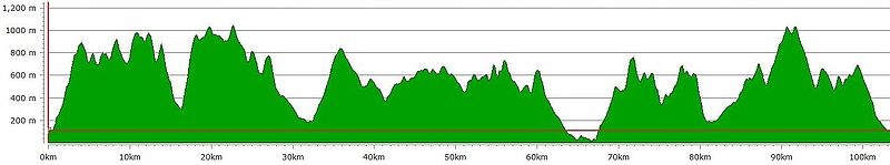
Route profile
Below is a profile of the route, again starting and finishing at Llanberis, running in a clockwise direction.