

Owensboro metropolitan area
Encyclopedia
The Owensboro Metropolitan Statistical Area, as defined by the United States Census Bureau
, is an area consisting of three counties in Kentucky
, anchored by the city of Owensboro
. As of the 2000 census
, the MSA had a population of 109,875 In the 2010 Census the population was 114,752. Owensboro is more closely defined as a part of Kentuckiana
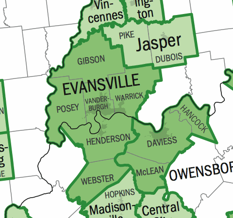
than the neighboring Evansville Metropolitan Area
even though at present all three counties are in Kentucky. The reason for this is that the primary city, Owensboro sits on the Ohio River
directly across from Spencer County, Indiana
, which is likely to become the fourth county in the metropolitan area. Perry County
is also like to become part of the area as well.
as a definition, as travel time decreases and interaction increases with improved infrastructure between the two areas and many of the micropolitan areas to the north and south like the new U.S. 231 Corridor and the expansion of the 6-lane Lloyd Expressway
as well as the interaction between Owensboro and Henderson along the Audubon Parkway
.
.
of 2000, there were 109,875 people, 43,232 households, and 30,142 families residing within the MSA. The racial makeup of the MSA was 94.46% White, 3.72% African American, 0.15% Native American, 0.37% Asian, 0.02% Pacific Islander, 0.41% from other races
, and 0.87% from two or more races. Hispanic or Latino of any race were 0.90% of the population.
The median income for a household in the MSA was $34,467, and the median income for a family was $41,240. Males had a median income of $33,012 versus $21,659 for females. The per capita income
for the MSA was $17,136.
United States Census Bureau
The United States Census Bureau is the government agency that is responsible for the United States Census. It also gathers other national demographic and economic data...
, is an area consisting of three counties in Kentucky
Kentucky
The Commonwealth of Kentucky is a state located in the East Central United States of America. As classified by the United States Census Bureau, Kentucky is a Southern state, more specifically in the East South Central region. Kentucky is one of four U.S. states constituted as a commonwealth...
, anchored by the city of Owensboro
Owensboro, Kentucky
Owensboro is the fourth largest city by population in the U.S. state of Kentucky. It is the county seat of Daviess County. It is located on U.S. Route 60 about southeast of Evansville, Indiana, and is the principal city of the Owensboro, Kentucky, Metropolitan Statistical Area. The city's...
. As of the 2000 census
United States Census, 2000
The Twenty-second United States Census, known as Census 2000 and conducted by the Census Bureau, determined the resident population of the United States on April 1, 2000, to be 281,421,906, an increase of 13.2% over the 248,709,873 persons enumerated during the 1990 Census...
, the MSA had a population of 109,875 In the 2010 Census the population was 114,752. Owensboro is more closely defined as a part of Kentuckiana
Kentuckiana
Kentuckiana is a name that is often used to refer to metropolitan areas with counties in both Indiana and Kentucky.* Louisville-Jefferson County, KY-IN Metropolitan Statistical Area, the area most commonly referred to as Kentuckiana...
than the neighboring Evansville Metropolitan Area
Evansville, IN-KY Metropolitan Statistical Area
The Evansville, IN-KY Metropolitan Statistical Area is the 142nd largest Metropolitan Statistical Area in the United States. The primary city is Evansville, Indiana. Other Indiana cities include Boonville, Mount Vernon, Oakland City, and Princeton...
even though at present all three counties are in Kentucky. The reason for this is that the primary city, Owensboro sits on the Ohio River
Ohio River
The Ohio River is the largest tributary, by volume, of the Mississippi River. At the confluence, the Ohio is even bigger than the Mississippi and, thus, is hydrologically the main stream of the whole river system, including the Allegheny River further upstream...
directly across from Spencer County, Indiana
Spencer County, Indiana
As of the census of 2000, there were 20,391 people, 7,569 households, and 5,752 families residing in the county. The population density was 51 people per square mile . There were 8,333 housing units at an average density of 21 per square mile...
, which is likely to become the fourth county in the metropolitan area. Perry County
Perry County, Indiana
Perry County is a county located in the southwestern part of the U.S. state of Indiana. As of 2010, the population was 19,338. The county seat is Tell City. It is the hilliest county as well as one of the most forested counties of in Indiana as it features more than of Hoosier National Forest...
is also like to become part of the area as well.
Possibilities for expansion and combination
There is a chance that the Owensboro and Evansville Metros could become the Evansville-Owensboro, IL-IN-KY Combined Statistical Area in 2010, further decreasing the use of KentuckianaKentuckiana
Kentuckiana is a name that is often used to refer to metropolitan areas with counties in both Indiana and Kentucky.* Louisville-Jefferson County, KY-IN Metropolitan Statistical Area, the area most commonly referred to as Kentuckiana...
as a definition, as travel time decreases and interaction increases with improved infrastructure between the two areas and many of the micropolitan areas to the north and south like the new U.S. 231 Corridor and the expansion of the 6-lane Lloyd Expressway
Lloyd Expressway
The Lloyd Expressway is a major east–west traffic artery in Evansville, Indiana. The road numbering consists of two segments. West of U.S. Route 41 , the road is State Road 62 , and east of US 41 it is SR 66...
as well as the interaction between Owensboro and Henderson along the Audubon Parkway
Audubon Parkway
The Audubon Parkway is a four-lane controlled-access freeway connecting the cities of Henderson and Owensboro, Kentucky....
.
Counties
- DaviessDaviess County, KentuckyAs of the census of 2000, there were 91,545 people, 36,033 households, and 24,826 families residing in the county. The population density was . There were 38,432 housing units at an average density of...
- HancockHancock County, KentuckyHancock County is a county located in the U.S. state of Kentucky. It was formed in 1829. As of 2000, the population was 8,392. It is included in the Owensboro, Kentucky, Metropolitan Statistical Area. Its county seat is Hawesville. The county is named for John Hancock...
- McLeanMcLean County, KentuckyMcLean County is a county located in the U.S. state of Kentucky; its population was 9,938 in the 2000 Census. McLean County's county seat is at Calhoun....
Incorporated places
- CalhounCalhoun, KentuckyCalhoun is a city in McLean County, Kentucky, United States. The population was 836 at the 2000 census. It is the county seat of McLean County. It is included in the Owensboro, Kentucky Metropolitan Statistical Area...
- HawesvilleHawesville, KentuckyHawesville is a city in Hancock County, Kentucky, United States, along the Ohio River. The population was 971 at the 2000 census. It is included in the Owensboro, Kentucky Metropolitan Statistical Area...
- IslandIsland, KentuckyIsland is a city in McLean County, Kentucky, United States. The population was 435 at the 2000 census. It is included in the Owensboro, Kentucky Metropolitan Statistical Area.-Geography:Island is located at ....
- LewisportLewisport, KentuckyLewisport is a city in Hancock County, Kentucky, United States, along the Ohio River. The population was 1639 at the 2000 census. It is included in the Owensboro, Kentucky Metropolitan Statistical Area.Founded in 1839, Lewisport is named for an early settler....
- LivermoreLivermore, KentuckyLivermore is a city in McLean County in the U.S. state of Kentucky, at the confluence of the Green and Rough Rivers. The population was 1,482 at the 2000 census. It is included in the Owensboro, Kentucky Metropolitan Statistical Area...
- OwensboroOwensboro, KentuckyOwensboro is the fourth largest city by population in the U.S. state of Kentucky. It is the county seat of Daviess County. It is located on U.S. Route 60 about southeast of Evansville, Indiana, and is the principal city of the Owensboro, Kentucky, Metropolitan Statistical Area. The city's...
(Principal city) - SacramentoSacramento, KentuckySacramento is a city in McLean County, Kentucky, United States. The population was 517 at the 2000 census. It is included in the Owensboro, Kentucky Metropolitan Statistical Area.-Geography:Sacramento is located at ....
- WhitesvilleWhitesville, KentuckyWhitesville is a city in Daviess County, Kentucky, United States. The population was 632 at the 2000 census. It is included in the Owensboro, Kentucky Metropolitan Statistical Area. The city was founded in 1844 by Dr. William White, and named for him...
Census-designated places
Note: Census-designated places are unincorporatedUnincorporated area
In law, an unincorporated area is a region of land that is not a part of any municipality.To "incorporate" in this context means to form a municipal corporation, a city, town, or village with its own government. An unincorporated community is usually not subject to or taxed by a municipal government...
.
- MasonvilleMasonville, KentuckyMasonville is a census-designated place in Daviess County, Kentucky, United States. The population was 1,075 at the 2000 census. It is included in the Owensboro Metropolitan Statistical Area.-Geography:Masonville is located at ....
Demographics
As of the censusCensus
A census is the procedure of systematically acquiring and recording information about the members of a given population. It is a regularly occurring and official count of a particular population. The term is used mostly in connection with national population and housing censuses; other common...
of 2000, there were 109,875 people, 43,232 households, and 30,142 families residing within the MSA. The racial makeup of the MSA was 94.46% White, 3.72% African American, 0.15% Native American, 0.37% Asian, 0.02% Pacific Islander, 0.41% from other races
Race (United States Census)
Race and ethnicity in the United States Census, as defined by the Federal Office of Management and Budget and the United States Census Bureau, are self-identification data items in which residents choose the race or races with which they most closely identify, and indicate whether or not they are...
, and 0.87% from two or more races. Hispanic or Latino of any race were 0.90% of the population.
The median income for a household in the MSA was $34,467, and the median income for a family was $41,240. Males had a median income of $33,012 versus $21,659 for females. The per capita income
Per capita income
Per capita income or income per person is a measure of mean income within an economic aggregate, such as a country or city. It is calculated by taking a measure of all sources of income in the aggregate and dividing it by the total population...
for the MSA was $17,136.