
Onkaparinga River National Park
Encyclopedia
Onkaparinga River National Park is in South Australia
(Australia
), 32 km south of Adelaide and incorporates the Onkaparinga River Recreation Park.
were inhabited by the Kaurna Aboriginal people, and the name of the river is taken from the Kaurna name meaning "women's river". European settlement and farming in the district began about 1840 leading to the rapid displacement of the Aboriginal inhabitants. Kaurna people still have strong ties to the area through cultural practices and religious beliefs. Many local place names such as ‘Onkaparinga’, ‘Noarlunga’ and ‘Willunga’ have their origins in the Kaurna language. The town of Noarlunga (renamed Old Noarlunga
) was the service centre with farm produce being transported 10 km down river to Port Noarlunga.
The remains of Pingle Farm, built in 1862, can be seen in the section of the park west of Main South Road. In 1878, several additional structures were built, including an underground water tank, a stone barn and a shed. The farm was occupied by the Jared family until the early 1970s when it was sold to the South Australian Government.
 2.5 hr loop, 4.5 km loop (Gate 31, 34).
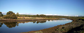
The Wetlands Walk is located on the estuary
within the recreation park and provides an
insight into the complex life
of a wetland. The trail offers the opportunity
for walking, birdwatching and photography.
Along the trail are interpretive signs that
provide information about the flora and
fauna of the area.
Built in 1862, all that remains of Pingle Farm is
a group of limestone buildings on the fertile
flood plains on the southern side of the
Onkaparinga River.
This patch of native vegetation is a very
important conservation area, despite a
history of timber cutting, quarrying and grazing.
The Nature Hike includes good views of the gorge, while trails provide an opportunity to view many species of
birds and the occasional lizard.
The Echidna Trail winds its way amongst some of the best remnant vegetation and visits six heritage sites, including huts and houses built in the 1880s. The dominant overstorey species is Peppermint Box, with River Red Gum in the gullies and Pink Gum on the higher slopes. Other plant species include sheoak, Golden Wattle, a small stand of native pine and various herbaceous ground covers. Twenty-seven native orchid species have been recorded in the area.
A relatively short hike to view the rocky outcrops and
meandering Onkaparinga River from the Sundews Lookout.
This hard trail takes you to gorge vantage points
before descending steeply to the river.
This rocky trail descends steeply from the
Sundews Lookout to the bottom of the gorge,
and then follows the river downstream for a short
distance before returning up the steep slopes of
the gorge to the ridge and then the car park.
designated cliff area near Gate 10. Specific skills and
equipment are required. Climbers are required to contact the Belair District Office first.
South Australia
South Australia is a state of Australia in the southern central part of the country. It covers some of the most arid parts of the continent; with a total land area of , it is the fourth largest of Australia's six states and two territories.South Australia shares borders with all of the mainland...
(Australia
Australia
Australia , officially the Commonwealth of Australia, is a country in the Southern Hemisphere comprising the mainland of the Australian continent, the island of Tasmania, and numerous smaller islands in the Indian and Pacific Oceans. It is the world's sixth-largest country by total area...
), 32 km south of Adelaide and incorporates the Onkaparinga River Recreation Park.
History
The lower reaches of the Onkaparinga RiverOnkaparinga River
The Onkaparinga River runs from its source between Mount Torrens and Charleston in the Mount Lofty Ranges, and flows south westerly to an estuary at Port Noarlunga. The catchment is over 500 km² in area, and is in part located in the Onkaparinga River National Park.The Onkaparinga River is the...
were inhabited by the Kaurna Aboriginal people, and the name of the river is taken from the Kaurna name meaning "women's river". European settlement and farming in the district began about 1840 leading to the rapid displacement of the Aboriginal inhabitants. Kaurna people still have strong ties to the area through cultural practices and religious beliefs. Many local place names such as ‘Onkaparinga’, ‘Noarlunga’ and ‘Willunga’ have their origins in the Kaurna language. The town of Noarlunga (renamed Old Noarlunga
Old Noarlunga, South Australia
Old Noarlunga is a small town approximately 40 minutes drive south of Adelaide, South Australia. Originally settled around 1840, the town retains its village atmosphere in spite of encroaching suburbia. At the 2006 census, Old Noarlunga had a population of 1,252.-History:In 1850 the South Australia...
) was the service centre with farm produce being transported 10 km down river to Port Noarlunga.
The remains of Pingle Farm, built in 1862, can be seen in the section of the park west of Main South Road. In 1878, several additional structures were built, including an underground water tank, a stone barn and a shed. The farm was occupied by the Jared family until the early 1970s when it was sold to the South Australian Government.
Flora and fauna
The vegetation of the park has been greatly perturbed by human activity, but remnant patches remain. The most intact area is the Hardy's Scrub section of the reserve. 160 years of livestock grazing, timber harvesting and cropping has cleared most of the reserve of native understorey species and in many areas invasive grasses are the main vegetation type. Remnant Eucalypts are the most noticeable native species in the reserve. Eucalyptus microcarpa (Grey Box), Eucalyptus fasciculosa (Pink Gum), Eucalyptus porosa (Mallee box), Eucalyptus Cameldulensis (Red Gum), and Eucalyptus leucoxylyn (Blue Gum) all occur in the reserve. The European Olive (Olea europaea) is a noxious weed in South Australia and has invaded the park, although generally individuals are not as large as in older parks in the Mount Lofty Ranges like Belair NP but will continue to be a problem unless managed. Over the last twenty years accessible areas of the gorge have been revegetated by contractors working for National Parks SA. The oldest area of revegetation in the park was conducted with tubestock, predominantly of Eucalypts. Recent efforts have focused on the direct seeding method where seed of native species is ploughed into a scraped trench. Insect activity includes butterflies (Lepidoptera) and dragonflies (Anisoptera). Kangaroos are common among the open hillsides with abundant grasses.Wetlands Walk
The Wetlands Walk is located on the estuary
within the recreation park and provides an
insight into the complex life
of a wetland. The trail offers the opportunity
for walking, birdwatching and photography.
Along the trail are interpretive signs that
provide information about the flora and
fauna of the area.
Pingle Farm Walk
2.5 hr loop, 4.5 km loop (Gate 29).Built in 1862, all that remains of Pingle Farm is
a group of limestone buildings on the fertile
flood plains on the southern side of the
Onkaparinga River.
Hardys Scrub Hike
2 hr loop, 4 km loop (Gate 11).This patch of native vegetation is a very
important conservation area, despite a
history of timber cutting, quarrying and grazing.
Nature Hike
2 hr loop, 3.5 km loop (Gate 6).The Nature Hike includes good views of the gorge, while trails provide an opportunity to view many species of
birds and the occasional lizard.
Echidna Hike
2.5 hr loop, 3.5 km loop (Gate 7).The Echidna Trail winds its way amongst some of the best remnant vegetation and visits six heritage sites, including huts and houses built in the 1880s. The dominant overstorey species is Peppermint Box, with River Red Gum in the gullies and Pink Gum on the higher slopes. Other plant species include sheoak, Golden Wattle, a small stand of native pine and various herbaceous ground covers. Twenty-seven native orchid species have been recorded in the area.
Sundews Ridge Hike
2 hr loop, 4 km loop (Gate 6).A relatively short hike to view the rocky outcrops and
meandering Onkaparinga River from the Sundews Lookout.
Gorge Track
4 hr return, 3.5 km return (Gate 18).This hard trail takes you to gorge vantage points
before descending steeply to the river.
Sundews River Hike
4 hr loop, 4.5 km loop (Gate 6).This rocky trail descends steeply from the
Sundews Lookout to the bottom of the gorge,
and then follows the river downstream for a short
distance before returning up the steep slopes of
the gorge to the ridge and then the car park.
Rock climbing
Climbing is permitted on thedesignated cliff area near Gate 10. Specific skills and
equipment are required. Climbers are required to contact the Belair District Office first.