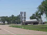
Oklahoma State Highway 95
Encyclopedia
State Highway 95 is a state highway
in the Panhandle
region of the U.S. state
of Oklahoma
. This route, which is only 42.1 miles (68 km) long, runs entirely through western Texas County
. SH-95 does not have any lettered spur routes.
 SH-95 begins where Farm to Market Road 1290 crosses into Oklahoma from Texas. Feet (meters) after crossing the state line, the highway curves to the west to parallel the state line as it approaches Texhoma
. In Texhoma, the route crosses US-54. SH-95 then turns north immediately after the intersection. It then bridges the Beaver River
and heads north for 19 miles (30.6 km), after which it meets US-64/412/SH-3.
SH-95 turns west to run concurrent with the other three routes. The four routes proceed together for 5 miles (8 km). SH-95 then splits off to the north at Four Corners. The route route then passes through Eva
and runs east of Surrey Hills before meeting US-56 just south of Elkhart, Kansas
. This intersection serves as SH-95's northern terminus.
Before 2003, SH-95 extended 0.1 mile (0.160934 km) beyond US-56 to the Kansas state line, connecting to K-27
. After KDOT
realigned K-27 to run east of Elkhart, ODOT truncated SH-95 to US-56.
State highway
State highway, state road or state route can refer to one of three related concepts, two of them related to a state or provincial government in a country that is divided into states or provinces :#A...
in the Panhandle
Oklahoma Panhandle
The Oklahoma Panhandle is the extreme western region of the state of Oklahoma, comprising Cimarron County, Texas County, and Beaver County. Its name comes from the similarity of shape to the handle of a cooking pan....
region of the U.S. state
U.S. state
A U.S. state is any one of the 50 federated states of the United States of America that share sovereignty with the federal government. Because of this shared sovereignty, an American is a citizen both of the federal entity and of his or her state of domicile. Four states use the official title of...
of Oklahoma
Oklahoma
Oklahoma is a state located in the South Central region of the United States of America. With an estimated 3,751,351 residents as of the 2010 census and a land area of 68,667 square miles , Oklahoma is the 28th most populous and 20th-largest state...
. This route, which is only 42.1 miles (68 km) long, runs entirely through western Texas County
Texas County, Oklahoma
Texas County is a county located in the U.S. state of Oklahoma. Texas County was formed at Oklahoma statehood from the central one-third of "Old Beaver County" also known as "No Man's Land"...
. SH-95 does not have any lettered spur routes.
Route description

Texhoma, Oklahoma
Texhoma is a town in Texas County, Oklahoma, United States. The population was 926 at the 2010 census. Founded around the Rock Island Railroad laying tracks through the area, much of the town's local economy is from ranching and livestock...
. In Texhoma, the route crosses US-54. SH-95 then turns north immediately after the intersection. It then bridges the Beaver River
Beaver River (Oklahoma)
The Beaver River is the historic name for an intermittent river in Oklahoma that drains most of the Oklahoma Panhandle. It is also known as the North Canadian River. Both names are in common use. By one convention the headwaters of the Beaver River are at the convergence of the Corrumpa, Rafael,...
and heads north for 19 miles (30.6 km), after which it meets US-64/412/SH-3.
SH-95 turns west to run concurrent with the other three routes. The four routes proceed together for 5 miles (8 km). SH-95 then splits off to the north at Four Corners. The route route then passes through Eva
Eva, Oklahoma
Eva is an unincorporated community in Texas County, Oklahoma, United States. It is located along State Highway 95. Four Corners is to the south....
and runs east of Surrey Hills before meeting US-56 just south of Elkhart, Kansas
Elkhart, Kansas
Elkhart is a city in and the county seat of Morton County, Kansas, United States. As of the 2010 census, the city population was 2,205.-Geography:Elkhart is located at...
. This intersection serves as SH-95's northern terminus.
History
State Highway 95 began as an unnumbered farm-to-market road. It was first assigned the SH-95 designation between 1950 and 1954. By 1955, US-56 had been established through Oklahoma. Its original route followed the section of SH-95 north of US-64, so SH-95 was truncated back to the US-64 junction.. This change was reverted in 1961, and US-56 and SH-95 ran concurrent north of US-64. The following year, US-56 was rerouted over SH-114, leaving SH-95 on its own once again.Before 2003, SH-95 extended 0.1 mile (0.160934 km) beyond US-56 to the Kansas state line, connecting to K-27
K-27 (Kansas highway)
K-27 is a long north–south state highway that parallels Kansas' western border with Colorado. It begins in Elkhart at the Oklahoma state line and travels through the seven counties that border Colorado until reaching its northern terminus in Cheyenne County north of St...
. After KDOT
Kansas Department of Transportation
The Kansas Department of Transportation is a state government organization in charge of maintaining public roadways of the U.S. state of Kansas.-Organization:*Secretary of Transportation...
realigned K-27 to run east of Elkhart, ODOT truncated SH-95 to US-56.

