
Ochoco Creek
Encyclopedia
Ochoco Creek is a 30 miles (48.3 km) tributary of the Crooked River
in the U.S. state
of Oregon
. Part of the drainage basin of the Columbia River
, it arises in the Ochoco National Forest
in Wheeler County
and flows generally southwest and west for most of its length through Crook County
to slightly northwest of Prineville
.
to the Crooked River near Prineville.
In its first 5 miles (8 km), Ochoco Creek receives Camp Creek from the left then Aholt and McAllister creeks, both from the right, then Judy, Fisher, and Canyon creeks, all from the left. At about river mile
(RM) 25 or river kilometer (RK 40), Coyle Creek and then Metal Creek enter from the right. Between there and the Ochoco Reservoir and Ochoco Lake State Park, the creek receives Garden Creek from the right, Douthit, Duncan, and Wolf creeks and Camp Branch, all from the left, and Salmon Creek from the right. Leaving the national forest, it receives Veasle and Lawson creeks from the left and Polly Creek from the right before entering the reservoir. As part of the lake, it receives Mill Creek from the right at about RM 12 (RK 19).
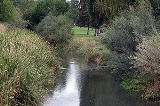
Flowing west from the lower end of the lake at about RM 9 (RK 14), the creek runs through the Prineville Golf and Country Club, passes under Highway 26 and enters Prineville and Ochoco Creek Park north of the highway at about RM 4 (RK 6). Turning northwest out of Prineville, the stream soon passes under Highway 26 again and enters the Crooked River roughly 47 miles (75.6 km) from its confluence with the Deschutes River, a tributary of the Columbia River.
Crooked River (Oregon)
The Crooked River is a tributary, long, of the Deschutes River in the U.S. state of Oregon. The river begins at the confluence of South Fork Crooked River and Beaver Creek. Of the two tributaries, the South Fork Crooked River is the larger and is sometimes considered part of the Crooked River proper...
in the U.S. state
U.S. state
A U.S. state is any one of the 50 federated states of the United States of America that share sovereignty with the federal government. Because of this shared sovereignty, an American is a citizen both of the federal entity and of his or her state of domicile. Four states use the official title of...
of Oregon
Oregon
Oregon is a state in the Pacific Northwest region of the United States. It is located on the Pacific coast, with Washington to the north, California to the south, Nevada on the southeast and Idaho to the east. The Columbia and Snake rivers delineate much of Oregon's northern and eastern...
. Part of the drainage basin of the Columbia River
Columbia River
The Columbia River is the largest river in the Pacific Northwest region of North America. The river rises in the Rocky Mountains of British Columbia, Canada, flows northwest and then south into the U.S. state of Washington, then turns west to form most of the border between Washington and the state...
, it arises in the Ochoco National Forest
Ochoco National Forest
The Ochoco National Forest is located in Central Oregon in the United States, north and east of the City of Prineville, location of the National Forest Headquarters. It encompasses of rimrock, canyons, geologic oddities, dense pine forests, and high desert terrain, as well as the headwaters of...
in Wheeler County
Wheeler County, Oregon
As of the census of 2000, there were 1,547 people, 653 households, and 444 families residing in the county. The population density was 1 people per square mile . There were 842 housing units at an average density of 0 per square mile...
and flows generally southwest and west for most of its length through Crook County
Crook County, Oregon
-Demographics:As of the census of 2000, there were 19,182 people, 7,354 households, and 5,427 families residing in the county. The population density was 6 people per square mile . There were 8,264 housing units at an average density of 3 per square mile...
to slightly northwest of Prineville
Prineville, Oregon
Prineville is a city in and the county seat of Crook County, Oregon, United States. It was named for the first merchant located in the present location, Barney Prine. The population was 9,253 at the 2010 census.- History :...
.
Course
Ochoco Creek begins in the extreme southwestern corner of Wheeler County near its border with Crook County in the Ochoco National Forest. Entering Crook County, it flows southwest for about two-thirds of its course, roughly parallel to Forest Road 22 and U.S. Route 26U.S. Route 26 in Oregon
In the U.S. state of Oregon, U.S. Route 26 is a major cross-state state highway, connecting U.S. Route 101 on the Oregon Coast near Seaside with the Idaho state line east of Nyssa. Local highway names include the Sunset Highway No. 47, Mount Hood Highway No. 26, and John Day Highway No...
to the Crooked River near Prineville.
In its first 5 miles (8 km), Ochoco Creek receives Camp Creek from the left then Aholt and McAllister creeks, both from the right, then Judy, Fisher, and Canyon creeks, all from the left. At about river mile
River mile
In the United States, a River mile is a measure of distance in miles along a river from its mouth. River mile numbers begin at zero and increase further upstream. The corresponding metric unit using kilometers is the River kilometer...
(RM) 25 or river kilometer (RK 40), Coyle Creek and then Metal Creek enter from the right. Between there and the Ochoco Reservoir and Ochoco Lake State Park, the creek receives Garden Creek from the right, Douthit, Duncan, and Wolf creeks and Camp Branch, all from the left, and Salmon Creek from the right. Leaving the national forest, it receives Veasle and Lawson creeks from the left and Polly Creek from the right before entering the reservoir. As part of the lake, it receives Mill Creek from the right at about RM 12 (RK 19).
Flowing west from the lower end of the lake at about RM 9 (RK 14), the creek runs through the Prineville Golf and Country Club, passes under Highway 26 and enters Prineville and Ochoco Creek Park north of the highway at about RM 4 (RK 6). Turning northwest out of Prineville, the stream soon passes under Highway 26 again and enters the Crooked River roughly 47 miles (75.6 km) from its confluence with the Deschutes River, a tributary of the Columbia River.