

Ocean Beach Public Policy
Encyclopedia
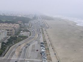
Ocean Beach is a beach that runs along the west coast of San Francisco, California
California
California is a state located on the West Coast of the United States. It is by far the most populous U.S. state, and the third-largest by land area...
, United States
United States
The United States of America is a federal constitutional republic comprising fifty states and a federal district...
, at the Pacific Ocean
Pacific Ocean
The Pacific Ocean is the largest of the Earth's oceanic divisions. It extends from the Arctic in the north to the Southern Ocean in the south, bounded by Asia and Australia in the west, and the Americas in the east.At 165.2 million square kilometres in area, this largest division of the World...
. It is adjacent to Golden Gate Park
Golden Gate Park
Golden Gate Park, located in San Francisco, California, is a large urban park consisting of of public grounds. Configured as a rectangle, it is similar in shape but 20% larger than Central Park in New York, to which it is often compared. It is over three miles long east to west, and about half a...
, the Richmond District
Richmond District
Richmond District may refer to:*Richmond District, San Francisco, California, an area of the city of San Francisco*Richmond District, Pennsylvania, a former area of the city of Philadelphia*Richmond District , a rail line in Virginia...
and the Sunset District. The Great Highway
Great Highway
The Great Highway is a road in San Francisco that forms the city's western edge along the Pacific coast. It runs for approximately next to Ocean Beach...
runs alongside the beach, and Cliff House
Cliff House
Cliff House may refer to:* Cliff House, the official residence of Chief Minister of Indian State of Kerala*Cliff House , a restaurant*The Cliff House , a condominium complex developed by the father of 47th U.S...
and the site of the former Sutro Baths
Sutro Baths
The Sutro Baths were a large, privately owned swimming pool complex in San Francisco, California, built in the late 19th century. The building housing the baths burned down in 1966 and was abandoned. The ruins may still be visited.- History :...
sit at the northern end. The beach is a part of the Golden Gate National Recreation Area
Golden Gate National Recreation Area
The Golden Gate National Recreation Area is a U.S. National Recreation Area administered by the National Park Service that surrounds the San Francisco Bay area. It is one of the most visited units of the National Park system in the United States, with over 13 million visitors a year...
, which is administered by the National Park Service
National Park Service
The National Park Service is the U.S. federal agency that manages all national parks, many national monuments, and other conservation and historical properties with various title designations...
.
Over the years, the City of San Francisco and the various public agencies that have jurisdictional control over Ocean Beach have been trying to figure out how to manage this area. Previous efforts and resolutions by the Ocean Beach Task Force (2000) and Ocean Beach Vision Council (2008) did not include a pathway to implementation, and thus a new effort is underway. The new approach that is being taken with the current Ocean Beach Master Plan is to have a non-profit lead the project and incorporate all relevant agencies into the dialogue so they can then incorporate recommendations into their respective agencies.
History/Background
The Ocean Beach Task Force (OBTF) was created in January 2000 by San Francisco's Mayor Willie BrownWillie Brown (politician)
Willie Lewis Brown, Jr. is an American politician of the Democratic Party. He served over 30 years in the California State Assembly, spending 15 years as its Speaker, and afterward served as the 41st mayor of San Francisco, the first African American to do so...
. The purpose of this task force was to address and preserve the environmental well-being of Ocean Beach
Ocean Beach, San Francisco, California
Ocean Beach is a beach that runs along the west coast of San Francisco, California, United States, at the Pacific Ocean. It is adjacent to Golden Gate Park, the Richmond District and the Sunset District. The Great Highway runs alongside the beach, and Cliff House and the site of the former Sutro...
as well as identify challenges and solutions for erosion, natural resources, recreation, and aesthetic issues.
The Ocean Beach Vision Council (OBVC) was created in March 2008 by San Francisco's Mayor Gavin Newsom
Gavin Newsom
Gavin Christopher Newsom is an American politician who is the 49th and current Lieutenant Governor of California. Previously, he was the 42nd Mayor of San Francisco, and was elected in 2003 to succeed Willie Brown, becoming San Francisco's youngest mayor in 100 years. Newsom was re-elected in 2007...
. The purpose of the OBVC was to propose "environmentally sustainable alternatives to improve beach access, enhance underutilized resources, and reconnect Ocean Beach to the city and its international visitors."
The Ocean Beach Master Plan
The current effort to develop a comprehensive plan for this section of San Francisco, CaliforniaCalifornia
California is a state located on the West Coast of the United States. It is by far the most populous U.S. state, and the third-largest by land area...
is the Ocean Beach Master Plan (OBMP). The OBMP is an interagency effort led by the non-profit, San Francisco Planning and Urban Research Association
San Francisco Planning and Urban Research Association
The San Francisco Planning and Urban Research Association, or SPUR, is a non-profit research, education, and advocacy organization focused on issues of planning and governance. SPUR's history dates back to 1910, when a group of young city leaders came together to improve the quality of housing...
(SPUR), to develop a long-term vision for Ocean Beach that will address a multitude of issues. Funding for this project is provided by $410,000 in government grants from the California State Coastal Conservancy, the San Francisco Public Utilities Commission, and the National Park Service. The goal of the OBMP is "to knit the unique assets and experiences of Ocean Beach into a seamless and welcoming public landscape, planning for environmental conservation, sustainable infrastructure and long-term stewardship." The OBMP also sets out to define a new approach to coastal resource management that strikes a balance between infrastructure needs, cultural, recreational, and natural-resource values, and one of the most pressing issues for modern day natural resource management: a changing climate.
The OBMP has identified seven major areas of focus to help organize and refine the complexities of such a comprehensive project. These areas include:
| Project Schedule |
|---|
| Startup (Jun-Aug 2010) |
| Problem Definition (Sep-Dec 2010) |
| Alternatives / Scenario Development (Jan-May 2011) |
| Draft Master Plan (Jun-Sep 2011) |
| Final Master Plan (Oct-Dec 2011) |
-
- Image and Character
- Access and Connectivity
- Ecology
- Program and Uses
- Coastal Dynamics & Climate Change
- Management & Stewardship
- Infrastructure
While all are essential to meeting the projects far-reaching goals, SPUR has identified ecology, coastal dynamics and climate change, and infrastructure as the three main areas of focus that will help shape the policies and recommendations for the remaining categories. The final product from this planning process will essentially be a series of project and policy recommendations for the respective agencies that have control over these various focus areas. The Ocean Beach Master Plan will not have the force of regulation on its own. However, once these agencies implement these recommendations and conduct environmental reviews under the California Environmental Quality Act
California Environmental Quality Act
The California Environmental Quality Act is a California statute passed in 1970, shortly after the United States federal government passed the National Environmental Policy Act , to institute a statewide policy of environmental protection...
or the National Environmental Policy Act
National Environmental Policy Act
The National Environmental Policy Act is a United States environmental law that established a U.S. national policy promoting the enhancement of the environment and also established the President's Council on Environmental Quality ....
, then the project can take effect.
1) Image & Character
- Goal: preserve and celebrate the beach's raw and open beauty while welcoming a broader public
On January 15, 2011, the first Ocean Beach Master Plan public workshop was held at the San Francisco Zoo
San Francisco Zoo
The San Francisco Zoo, housing more than 260 animal species, is a zoo located in the southwestern corner of San Francisco, California, between Lake Merced and the Pacific Ocean along the Great Highway...
in an effort to inform the public about the project and to collect feedback from the community and other interested parties. One of themes that permeated the public comments was the desire to keep Ocean Beach 'natural' and maintain its wild quality. Although Ocean Beach is technically within the city limits, many visitors use this urban beach as an escape from the city. The OBMP project team has recognized this observation and aims to address the built and natural environment of Ocean Beach with landscape design that can represent this place's unique image and character
Ocean Beach, San Francisco, California
Ocean Beach is a beach that runs along the west coast of San Francisco, California, United States, at the Pacific Ocean. It is adjacent to Golden Gate Park, the Richmond District and the Sunset District. The Great Highway runs alongside the beach, and Cliff House and the site of the former Sutro...
.
2) Access and Connectivity
- Goal: provide seamless and fluid connections to adjacent open spaces, the city, and the region
Ocean beach is not only a popular destination in itself for beach-goers, nature lovers, and sports enthusiasts alike, but acts as an important corridor linking may of the city’s open spaces and transit ways for both residents and visitors. The Great Highway
Great Highway
The Great Highway is a road in San Francisco that forms the city's western edge along the Pacific coast. It runs for approximately next to Ocean Beach...
, built in the 1920s, and once the widest stretch of pavement for its length in the world, connects Sutro Baths
Sutro Baths
The Sutro Baths were a large, privately owned swimming pool complex in San Francisco, California, built in the late 19th century. The building housing the baths burned down in 1966 and was abandoned. The ruins may still be visited.- History :...
and Lands End at the northern end of Ocean Beach to Golden Gate Park
Golden Gate Park
Golden Gate Park, located in San Francisco, California, is a large urban park consisting of of public grounds. Configured as a rectangle, it is similar in shape but 20% larger than Central Park in New York, to which it is often compared. It is over three miles long east to west, and about half a...
, the San Francisco Zoo
San Francisco Zoo
The San Francisco Zoo, housing more than 260 animal species, is a zoo located in the southwestern corner of San Francisco, California, between Lake Merced and the Pacific Ocean along the Great Highway...
and Fort Funston
Fort Funston
Fort Funston is a protected area within the Golden Gate National Recreation Area at the southwestern corner of San Francisco. It occupies windswept headlands along the Pacific coast, steep cliffs and the beach below...
to the south. Narrowed in the 1990s by nearly half, the Great Highway still acts as a major artery connecting California’s historic Highway 1 to the Golden Gate Bridge
Golden Gate Bridge
The Golden Gate Bridge is a suspension bridge spanning the Golden Gate, the opening of the San Francisco Bay into the Pacific Ocean. As part of both U.S. Route 101 and California State Route 1, the structure links the city of San Francisco, on the northern tip of the San Francisco Peninsula, to...
. San Francisco Municipal Railway
San Francisco Municipal Railway
The San Francisco Municipal Railway is the public transit system for the city and county of San Francisco, California. In 2006, it served with an operating budget of about $700 million...
's (MUNI) transit system provides plentiful public transportation options, including the N-Judah, L-Taraval, and 38-Geary lines, which all end within easy walking distance to the beach. However, pedestrian access ways from public transit to Ocean Beach have been criticized as inadequate and oftentimes confusing. While on a normal usage day plentiful parking can be found along the beach, on hot sunny days when crowds swell parking can often be difficult, highlighting the need for improved public transport options.
A multimodal vision for the future?
The City of San Francisco has recently hosted their Sunday Streets program at Ocean Beach several times, closing the Great Highway to cars and offering a full day for bicyclists, pedestrians, and skateboarders to enjoy the open space along the beach car free. The San Francisco Bicycle Coalition
San Francisco Bicycle Coalition
The San Francisco Bicycle Coalition is a California 501 nonprofit public benefit corporation established to "transform San Francisco's streets and neighborhoods into more livable and safe places by promoting the bicycle for everyday transportation." Founded in 1971, dormant through much of the...
has also recently launched a campaign to build a bikeway from SF Bay to Ocean Beach.
3) Ecology


- Goal: restore and establish conditions that support thriving biological communities
The beach and the dune system at Ocean Beach provide habitat for numerous species; including two birds which are listed as threatened.
The dune system spans about a mile between Great Highway and the beach; starting around the edge of Golden Gate Park and ending around Noriega Street. This ecosystem consists of predominantly non-native vegetation such as ice plant (Carpobrotus edulis) and European dune grass (Ammophila arenaria
Ammophila arenaria
Ammophila arenaria is a species of grass known by the common names European Marram Grass and European Beachgrass. It is one of two species of the genus Ammophila . It is native to the coastlines of Europe and North Africa where it grows in the sands of beach dunes. It is a perennial grass forming...
). Many participants at the first public workshop suggested restoring the dunes with native species. Although the OBMP project team will examine this proposal as a possible alternative, they predict that it will most likely be very costly.
The bank swallow
Sand Martin
The Sand Martin is a migratory passerine bird in the swallow family. It has a wide range in summer, embracing practically the whole of Europe and the Mediterranean countries, part of northern Asia and also North America. It winters in eastern and southern Africa, South America and South Asia...
is a state-listed threatened species that inhabits hollows in the bluffs at the south end of Ocean Beach (just south of the Sloat parking lot). The bank swallow colony that lives here inhabits more than one hundred burrows and is the northern most major colony on the California coast. Due to the threat of erosion, this sensitive habitat is at risk of destruction from the ocean or from the proposed coastal armoring aimed at protecting the integrity of the bluffs. In an effort to protect the bank swallows, the San Francisco Department of Public Works
San Francisco Department of Public Works
The San Francisco Department of Public Works is responsible for the care and maintenance of San Francisco’s streets and much of its infrastructure...
(SFDPW) ceases work in this area during their breeding season (April to August).
While the bank swallows occupy the southern end of Ocean Beach, the Western Snowy Plover (Charadrius alexandrinus nivosus) inhabit the central part of the beach where the sand is dry. Because Snowy Plovers (plovers) prefer the flat, sandy areas of the beach they are frequently disturbed by human recreational activities. In addition to altering their habitat, these disturbances can contribute to high rates of nest failure and chick mortality. Furthermore, frequent disturbances can disrupt caloric accumulation and result in diminished migration and breeding success. The Western Snowy Plover is a federally listed threatened species so the National Park Service
National Park Service
The National Park Service is the U.S. federal agency that manages all national parks, many national monuments, and other conservation and historical properties with various title designations...
(NPS) has taken measures to protect this species by limiting access to certain parts of the beach where plovers nest.
4) Program & Uses
- Goal: accommodate diverse activities and users, managed for positive coexistence
Due to Ocean Beach's recreational opportunities, this area is utilized by a wide range of users; from surfers to bird watchers, cyclists to dog walkers. For the most part these various activities are able to share this space without conflict; however, some have inherent competing interests. For example, bird watchers and people concerned with the threatened bird species that inhabit Ocean Beach are at odds with the beach goers who bring dogs to the beach and disturb their habitat. The National Park Service
National Park Service
The National Park Service is the U.S. federal agency that manages all national parks, many national monuments, and other conservation and historical properties with various title designations...
issued a Draft Dog Management Plan in January 2011 to address this concern and the effects that dogs are having in the Golden Gate National Recreation Area
Golden Gate National Recreation Area
The Golden Gate National Recreation Area is a U.S. National Recreation Area administered by the National Park Service that surrounds the San Francisco Bay area. It is one of the most visited units of the National Park system in the United States, with over 13 million visitors a year...
, including Ocean Beach. Currently, the NPS does not allow dogs in the Snowy Plover Protection Area (SPPA) located at the northern end of Ocean Beach. The Draft Dog Management Plan's preferred alternative would further limit dog access as follows:
- allows on leash dog walking on the trail along the Great Highway
- regulated off-leash area on the beach north of Stairwell #21
- no dogs on the beach south of Sloat Blvd.
- no dogs in the Snowy Plover Protection Area (SPPA)
5) Coastal Dynamics & Climate Change
- Goal: identify a proactive approach to coastal management, in the service of desired outcomes
For the last two hundred and fifty years, humankind’s industrial and agricultural activities have been releasing carbon dioxide
Carbon dioxide
Carbon dioxide is a naturally occurring chemical compound composed of two oxygen atoms covalently bonded to a single carbon atom...
(CO2) and other greenhouse gases (GHGs) into the atmosphere at ever increasing rates. Pre-industrial atmospheric CO2 concentrations of ~280 ppmv (parts per million by volume) have risen steadily to the current rate of ~388 ppmv in 2009, a level that the Earth
Earth
Earth is the third planet from the Sun, and the densest and fifth-largest of the eight planets in the Solar System. It is also the largest of the Solar System's four terrestrial planets...
has not experienced in at least the last 800,000 years. Industrial burning of fossil fuels, as well as cement production, automotive emissions, and deforestation
Deforestation
Deforestation is the removal of a forest or stand of trees where the land is thereafter converted to a nonforest use. Examples of deforestation include conversion of forestland to farms, ranches, or urban use....
practices are the main contributors to elevated CO2 emissions, each of these a result of the increasingly global industrialization of our world. As carbon dioxide and other greenhouse gas levels rise, a multitude of changes to important climate properties are expected to occur: significantly increased surface temperatures - both oceanic and atmospheric, variability in storm frequency and strength, sea-ice loss, changes in rainfall patterns and sea level rise, as well as important changes in the carbonate chemistry of the oceans. Climate change may first be apparent along vulnerable, exposed coastlines like that of San Francisco’s Ocean Beach, therefore, a comprehensive management plan that attempts to take these many factors into account is essential. The Intergovernmental Panel on Climate Change
Intergovernmental Panel on Climate Change
The Intergovernmental Panel on Climate Change is a scientific intergovernmental body which provides comprehensive assessments of current scientific, technical and socio-economic information worldwide about the risk of climate change caused by human activity, its potential environmental and...
(IPCC)’s Fourth Assessment Report
IPCC Fourth Assessment Report
Climate Change 2007, the Fourth Assessment Report of the United Nations Intergovernmental Panel on Climate Change , is the fourth in a series of reports intended to assess scientific, technical and socio-economic information concerning climate change, its potential effects, and options for...
released in 2007 projected with “very high confidence” that coastal systems will face the following threats due to climate change:
- Coasts will be exposed to increasing risks such as coastal erosion due to climate change and sea-level rise.
- "Increases in sea-surface temperature of about 1-3 °C are projected to result in more frequent coral bleaching events and widespread mortality unless there is thermal adaptation or acclimatization by corals."
- "Many millions more people are projected to be flooded every year due to sea-level rise by the 2080s."
Erosion
Seasonal and yearly beach and shoreline fluctuation is a naturally occurring process. These natural fluctuations in beach width and shape only become an erosion problem when permanent structures, such as roads, parking lots, and walkways are placed at fixed points near the beach, within this zone of fluctuation. As the shoreline recedes, roads, neighborhoods and other infrastructure will need to be protected or abandoned. The Oceanside Water Pollution Control Plant
Oceanside Water Pollution Control Plant
The Oceanside Water Pollution Control Plant is a wastewater treatment plant operated by the San Francisco Public Utilities Commission, in San Francisco, California, United States. The award-winning facility is noted for its mostly underground construction inside a hollowed-out hill...
(OWPCP) and its surrounding roadways situated at the south end of Sloat Blvd. were planned and built in the 1980‘s to early 1990‘s, when the Beach at this end was naturally wide. After several years of severe storm events including major storms in both 1997 and again during the el niño winter of 2009-2010, the south end of Ocean Beach near the OWPCP began experiencing severe erosion. In 2010, bluff tops receded as much as 40 feet, undermining parking lots as well as the shoulder of the Great Highway, which ended up being closed southbound for much of the year. Underlying sewer pipes connected to the OWPCP also became threatened by erosion. In 2010 the city’s emergency response was the construction of 425 feet of rock revetments (embankments of stone riprap
Riprap
Riprap — also known as rip rap, rubble, shot rock or rock armour or "Rip-rap" — is rock or other material used to armor shorelines, streambeds, bridge abutments, pilings and other shoreline structures against scour, water or ice erosion.It is made from a variety of rock types, commonly granite or...
) along this portion of OB. Though temporarily effective, this type of emergency erosion control often draws criticism from environmentalists for causing unnecessary beach and habitat loss.
Sea-Level Rise and Increased Storm Severity
Another likely effect of climate change that may have a significant impact on Ocean Beach is sea-level rise:
- The 2007 Intergovernmental Panel on Climate ChangeIntergovernmental Panel on Climate ChangeThe Intergovernmental Panel on Climate Change is a scientific intergovernmental body which provides comprehensive assessments of current scientific, technical and socio-economic information worldwide about the risk of climate change caused by human activity, its potential environmental and...
report suggests that global average sea level may rise between 0.6 and 2 feet (7.2 inches - 24 inches) by the end of this century. - The State of California has predicted that sea-level will rise by 16 inches by 2050 and 55 inches by 2100.
- A study released by the International Arctic Monitoring and Assessment Program (AMAP) in May 2011 predicts that sea level will rise as much as 63 inches by 2100.
Accelerated sea-level rise will likely lead to increased coastal erosion along Ocean Beach. Bluffs and beaches may be exposed to more powerful and more frequent wave action due to both elevated seas and an increase in storm frequency and severity, anther effect of climate change that has been predicted by the IPCC. Protecting the beach, dunes, and any man-made structures from the effects of erosion will require some form of erosion control measure. Currently three options for the management of erosion at Ocean Beach have been utilized or are being considered:
Coastal Armoring
Coastal armoring is a protective measure that seeks to prevent erosion by placing hard structures such as seawalls or revetments (sometimes referred to as riprap
Riprap
Riprap — also known as rip rap, rubble, shot rock or rock armour or "Rip-rap" — is rock or other material used to armor shorelines, streambeds, bridge abutments, pilings and other shoreline structures against scour, water or ice erosion.It is made from a variety of rock types, commonly granite or...
) along a receding shoreline. Currently there are approximately linear 10,000 feet of hard structures at Ocean Beach, including three existing seawalls and more recently placed revetments.
Beach Nourishment
Beach nourishment
Beach nourishment
Beach nourishment— also referred to as beach replenishment—describes a process by which sediment lost through longshore drift or erosion is replaced from sources outside of the eroding beach...
, or the process of replacing lost sediment within the littoral cell, is another option to counteract erosion at Ocean Beach. Beach nourishment is a potentially promising option as the US Army Corps of Engineers (USACE) currently dredge 300,000 cubic yards of sand within the San Francisco Bay annually. In 2006, USACE led a demonstration project to determine if beach nourishment is a promising solution to the erosion problem at Ocean Beach. There is currently an effort underway to retrofit the Army Corps’ dredge, the Essayons, so that it can pump sand directly onto the beach at Ocean Beach, which would help reestablish a wide beach north of Sloat Blvd. (Need CITE)
Managed Retreat
Managed retreat
Managed retreat
In the context of coastal erosion, managed retreat allows an area that was not previously exposed to flooding by the sea to become flooded by removing coastal protection...
is the gradual removal of manmade structures that may be exposed to flooding due to an advancing coastline. This strategy is relatively simple and effective when it comes to structures such as roads or parking lots, but for several structures in the vicinity of Ocean Beach, including the publicly-funded Oceanside Wastewater Treatment Plant, managed retreat may be a much more difficult option to pursue. (Need CITE)
6) Management & Stewardship
- Goal: provide an approach to long-term stewardship across agencies, properties and jurisdictions
Key Stakeholders
The management of Ocean Beach and the surrounding area has been complicated by jurisdictional issues and the oftentimes competing interests of the many stakeholders that play some role in OB governance. This list includes many local, state, and federal regulatory agencies, local businesses, and nearby residents. The creation of the current OBMP attempts to address this regulatory hodgepodge by bringing together the goals and objectives of these various agencies and constituents into one cohesive managerial plan.
Jurisdictional Issues
One of the biggest challenges to creating a comprehensive management plan for Ocean Beach are complicated jurisdictional issues. The following federal, state and local regulatory agencies play some role in owning/managing the beach:
The National Park Service
National Park Service
The National Park Service is the U.S. federal agency that manages all national parks, many national monuments, and other conservation and historical properties with various title designations...
(NPS) is the owner and manager of Ocean Beach, which is completely encompassed within the Golden Gate National Recreation Area
Golden Gate National Recreation Area
The Golden Gate National Recreation Area is a U.S. National Recreation Area administered by the National Park Service that surrounds the San Francisco Bay area. It is one of the most visited units of the National Park system in the United States, with over 13 million visitors a year...
(GGNRA). Areas around Ocean Beach are managed by various city agencies, including: the Department of Public Works, which manages the roadways and other surrounding infrastructure, San Francisco Recreation and Park Department (SFRPD), which manages Golden Gate Park
Golden Gate Park
Golden Gate Park, located in San Francisco, California, is a large urban park consisting of of public grounds. Configured as a rectangle, it is similar in shape but 20% larger than Central Park in New York, to which it is often compared. It is over three miles long east to west, and about half a...
and the multi-use pathway bordering Ocean Beach, and the San Francisco Public Utilities Commission
San Francisco Public Utilities Commission
The San Francisco Public Utilities Commission is a public agency of the City and County of San Francisco that provides water, wastewater, and power services to the City and an additional 1.6 million customers within three San Francisco Bay Area counties.The SFPUC manages a complex water supply...
(SFPUC), which manages the Oceanside Water Pollution Control Plant
Oceanside Water Pollution Control Plant
The Oceanside Water Pollution Control Plant is a wastewater treatment plant operated by the San Francisco Public Utilities Commission, in San Francisco, California, United States. The award-winning facility is noted for its mostly underground construction inside a hollowed-out hill...
and underground sewer lines. The shoreline falls under federal jurisdiction, and so is subject to other regulatory agencies, including the California Coastal Commission
California Coastal Commission
The California Coastal Commission is a state agency in the U.S. state of California with quasi-judicial regulatory oversight over land use and public access in the California coastal zone....
and the Army Corps of Engineers.
Community/neighborhood groups
In addition to the regulatory agencies mentioned above, there are numerous community groups, environmental organizations, neighborhood businesses, and local residents that also act as stakeholders, ultimately having some say in any decisions that are made regarding Ocean Beach. Reconciling these various groups' goals, objectives, and oftentimes differing priorities is a complicated yet essential task that has been emphasized throughout the Ocean Beach Master Plan planning process. SPUR has compiled a Preliminary Public Feedback Summary from their January 15, 2011 Ocean Beach public input meeting; and the following are some of the various community, environmental, and neighborhood groups that have participated in the current OBMP planning process:
- Black Rock Arts FoundationBlack Rock Arts FoundationThe Black Rock Arts Foundation was established May 2001 in order to promote public, community-based art installations. It is a not-for-profit organization, founded by several people who also direct Burning Man...
- Coalition to Save Ocean Beach/Friends of Sutro Heights
- Coastal Sediment Management Workgroup (CSMW)
- Golden Gate National Parks ConservancyGolden Gate National Parks ConservancyEstablished in 1981, the Golden Gate National Parks Conservancy is the nonprofit partner that supports and assists the Golden Gate National Parks in research, interpretation, and conservation programs....
- Golden Gate Audubon Society
- Great Streets Project
- Neighborhood Parks Council
- Planning Association of the Richmond/Friends of Sutro Height
- Save the Waves Coalition
- San Francisco Bicycle CoalitionSan Francisco Bicycle CoalitionThe San Francisco Bicycle Coalition is a California 501 nonprofit public benefit corporation established to "transform San Francisco's streets and neighborhoods into more livable and safe places by promoting the bicycle for everyday transportation." Founded in 1971, dormant through much of the...
- San Francisco Zoological Society
- Surfrider Foundation
- SPURSpurA spur is a metal tool designed to be worn in pairs on the heels of riding boots for the purpose of directing a horse to move forward or laterally while riding. It is usually used to refine the riding aids and to back up the natural aids . The spur is used in every equestrian discipline...
7) Infrastructure
- Goal: evaluate infrastructure plans and needs in light of uncertain coastal conditions, and pursue a smart, sustainable approach
Great Highway
The Great Highway is a road in San Francisco that forms the city's western edge along the Pacific coast. It runs for approximately next to Ocean Beach...
were scoured away, resulting in parts of the road and parking lots crumbling into the ocean and a portion of the Lake Merced
Lake Merced
Lake Merced is a freshwater lake in the southwest corner of San Francisco. It is surrounded by three golf courses , as well as residential areas, Lowell High School, San Francisco State University, Fort Funston and the Pacific Ocean...
Wastewater Tunnel becoming exposed.
The Great Highway
Great Highway
The Great Highway is a road in San Francisco that forms the city's western edge along the Pacific coast. It runs for approximately next to Ocean Beach...
is a four-lane (two lanes in each direction) expressway that runs approximately 3.5 miles along Ocean Beach. The route's northern end beings at Point Lobos Ave and extends to the Skyline Blvd. at the southern end where it connects with Route 35
California State Route 35
State Route 35 in the U.S. state of California, generally known as Skyline Boulevard, is a two-lane road running along the western ridge of Silicon Valley in California. It runs from Highway 17 to San Francisco at State Route 1. It provides scenic views of both the Santa Cruz Mountains, the...
. In January 2011, San Francisco officials ordered both southbound lanes of the Great Highway near Sloat Blvd. closed until summer due to erosion occurring along the bluffs in this area. The detour along Skyline Blvd. raises the question: can this become a permanent alternative route?
Since these erosion events are occurring every winter and climate change forecasts increased severity and frequency of winter storms, a more permanent solution needs to be implemented. Another alternative would be to reduce the number of lanes and convert the two lanes furthest away from the coast into a single lane in each direction (as per the previous recommendations set forth by the OBTF). A transportation analysis would need to be conducted by the OBMP team to determine the impacts that such a reduction in lane-use would have on traffic.
The Lake Merced
Lake Merced
Lake Merced is a freshwater lake in the southwest corner of San Francisco. It is surrounded by three golf courses , as well as residential areas, Lowell High School, San Francisco State University, Fort Funston and the Pacific Ocean...
Wastewater Tunnel is another piece of infrastructure in this area which has been analyzed for relocation. The tunnel is located at the southern end of Ocean Beach where the worst of the erosion is occurring. The purpose of the tunnel is to store runoff and prevent overflows during storms when large amounts of water inundate the combined sewer-stormwater system. Local officials are concerned that untreated sewage could spill onto the beach and into the ocean if the tunnel becomes compromised due to damage from erosion. The San Francisco Department of Public Works
San Francisco Department of Public Works
The San Francisco Department of Public Works is responsible for the care and maintenance of San Francisco’s streets and much of its infrastructure...
has looked into the costs of relocating the tunnel and its associated structures but the figures are costly. Moving the tunnel alone would cost an estimated $110.46 million. If the associated Southwest Ocean Outfall (SWOO) pipe and other pressurized pipes are moved as well the total cost would rise to almost $167 million. Since the relocation costs are high, alternatives that protect the pipe rather than move it are being considered and evaluated. One option would be to strengthen the tunnel/pipe from within. By thickening its inner walls, the tunnel will lose storage capacity, however it will increase structural integrity. Another option is protecting the exposed tunnel with coastal armoring.
Similar to the Lake Merced
Lake Merced
Lake Merced is a freshwater lake in the southwest corner of San Francisco. It is surrounded by three golf courses , as well as residential areas, Lowell High School, San Francisco State University, Fort Funston and the Pacific Ocean...
Wastewater Tunnel, the Westside Transport Box acts as storage for the Oceanside Water Pollution Control Plant
Oceanside Water Pollution Control Plant
The Oceanside Water Pollution Control Plant is a wastewater treatment plant operated by the San Francisco Public Utilities Commission, in San Francisco, California, United States. The award-winning facility is noted for its mostly underground construction inside a hollowed-out hill...
when this facility's capacity is overwhelmed. The transport box is a large rectangular tube that runs under the Great Highway
Great Highway
The Great Highway is a road in San Francisco that forms the city's western edge along the Pacific coast. It runs for approximately next to Ocean Beach...
from Lincoln Way to Sloat Blvd. Unlike the tunnel, the transport box is not in any immediate danger from erosion. Instead this section of the City's stormwater-sewage infrastructure may become a significant factor in shaping the beach and dunes as the coastline recedes. If the coastline along Ocean Beach recedes past the current seawalls, the Westside Transport Box could act as a last line of defense to rising sea levels.
External links
- California Coastal Records Project
- GGNRA - Dog Management Draft Plant/DEIS
- Ocean Beach Bulletin, local news organization
- Ocean Beach Task Force Report (2005)
- SPUR
- SPUR Report, 5/2011: Climate Change Hits Home: Adaptation Strategies for the San Francisco Bay Area
- Sunset Beacon, local newspaper
- Sunset District Events Calendar, local events calendar
- Surfrider Foundation's Save Sloat Campaign
- Western Neighborhoods Project