
Oberhalbstein Range
Encyclopedia
The Oberhalbstein Range (Italian: Alpi del Platta) is a mountain range
in the Alps
of eastern Switzerland
and northern Italy
. It is considered to be part of the Central Eastern Alps
. The Oberhalbstein Range is separated from the Lepontine Alps
in the west by the Splügen Pass
; from the Plessur Range
in the north by the Albula river
valley; from the Albula Range
in the east by the Septimer Pass
and the Julia River
; from the Bernina Range
in the south by the Val Bregaglia
.
The Oberhalbstein Range is drained by the rivers Hinterrhein, Julia
, Liro and Mera
.
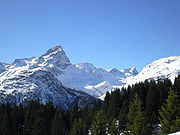
 The main peaks of the Oberhalbstein Range are:
es of the Oberhalbstein Range are:
Mountain range
A mountain range is a single, large mass consisting of a succession of mountains or narrowly spaced mountain ridges, with or without peaks, closely related in position, direction, formation, and age; a component part of a mountain system or of a mountain chain...
in the Alps
Alps
The Alps is one of the great mountain range systems of Europe, stretching from Austria and Slovenia in the east through Italy, Switzerland, Liechtenstein and Germany to France in the west....
of eastern Switzerland
Switzerland
Switzerland name of one of the Swiss cantons. ; ; ; or ), in its full name the Swiss Confederation , is a federal republic consisting of 26 cantons, with Bern as the seat of the federal authorities. The country is situated in Western Europe,Or Central Europe depending on the definition....
and northern Italy
Italy
Italy , officially the Italian Republic languages]] under the European Charter for Regional or Minority Languages. In each of these, Italy's official name is as follows:;;;;;;;;), is a unitary parliamentary republic in South-Central Europe. To the north it borders France, Switzerland, Austria and...
. It is considered to be part of the Central Eastern Alps
Central Eastern Alps
The Central Eastern Alps comprise the main chain of the Eastern Alps with its highest peaks, located between the Northern Limestone Alps and the Southern Limestone Alps, from which they differ in geological composition....
. The Oberhalbstein Range is separated from the Lepontine Alps
Lepontine Alps
The Lepontine Alps are a mountain range in the central part of the Alps. They are located in Switzerland and Italy .On the north the upper Rhône valley separate them from the Bernese Alps and the Furka Pass and the upper Reuss valley separates them from the Urner Alps; on the west the Simplon Pass...
in the west by the Splügen Pass
Splügen Pass
The Splügen Pass is a high mountain pass which marks the boundary between the Lepontine and Rhaetian Alps....
; from the Plessur Range
Plessur Range
The Plessur Range is a mountain range in the Alps of eastern Switzerland. It is considered to be part of the Central Eastern Alps. It is named after the river Plessur, which originates from the center of the ranges...
in the north by the Albula river
Albula River
Albula is a river of Switzerland, a tributary of Hinterrhein . Length: 36 km , Basin: 950 km² ....
valley; from the Albula Range
Albula Range
The Albula Alps is a mountain range in the Alps of eastern Switzerland. It is considered to be part of the Central Eastern Alps. It is named after the River Albula...
in the east by the Septimer Pass
Septimer Pass
Septimer Pass is a high mountain pass in the canton of Graubünden in the Swiss Alps between the valleys of Bregaglia and Oberhalbstein ....
and the Julia River
Julia River
Julia is a river in the Grisons canton, eastern Switzerland. It is a tributary of the Albula river, which it meets in Tiefencastel. The road to the Julier Pass runs through the Julia valley....
; from the Bernina Range
Bernina Range
The Bernina Range is a mountain range in the Alps of eastern Switzerland and northern Italy. It is considered to be part of the Central Eastern Alps. It is one of the highest ranges of the Alps, covered with many glaciers. Piz Bernina , its highest peak, is the most easterly four thousand-metre...
in the south by the Val Bregaglia
Val Bregaglia
The Val Bregaglia or Bergell Tal is an alpine valley of Switzerland and Italy at the base of which runs the river Mera River...
.
The Oberhalbstein Range is drained by the rivers Hinterrhein, Julia
Julia River
Julia is a river in the Grisons canton, eastern Switzerland. It is a tributary of the Albula river, which it meets in Tiefencastel. The road to the Julier Pass runs through the Julia valley....
, Liro and Mera
Mera River
The Mera is a river in Switzerland and Italy. Its source is near the Maloja Pass, in Graubünden, Switzerland. It flows west through the Val Bregaglia and crosses the Italian border near Soglio...
.
Peaks
| Peak | |Elevation (m/ft) | |
|---|---|---|
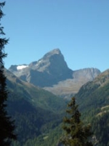
| Piz Platta Piz Platta Piz Platta is the highest peak in the Oberhalbstein Range, located in Graubünden, Switzerland. It is 3392 metres high , and is notable for its similarity in shape to the Matterhorn.-External links:*... |
3386 | 11,109 |
| Piz Forbesch Piz Forbesch The Piz Forbesch is a mountain in the Oberhalbstein Range, located in Graubünden, Switzerland.-External links:*... |
3258 | 10,689 |
| Piz Timun Piz Timun The Piz Timun is a mountain in the Oberhalbstein Range located on the border between Italy and Switzerland.-External links:*... |
3201 | 10,502 |
| Pizzo Stella | 3162 | 10,375 |
| Piz Duan Piz Duan The Piz Duan is a mountain in the Oberhalbstein Range, located in Graubünden, Switzerland.-External links:*... |
3133 | 10,279 |
| Pizz Gallagiun Pizz Gallagiun The Pizz Gallagiun is a mountain in the Oberhalbstein Range located on the border between Italy and Switzerland.-External links:*... |
3107 | 10,200 |
| Gletscherhorn | 3106 | 10,191 |
| Cima da Lägh Cima da Lägh Cima da Lägh is a mountain in the Oberhalbstein Range of the Alps located on the border between Italy and Switzerland.-External links:*... |
3082 | 10,112 |
| Piz Grisch Piz Grisch Piz Grisch is a mountain in the Oberhalbstein Range, located in Graubünden, Switzerland.-External links:*... |
3062 | 10,050 |
| Usser Wissberg | 3053 | 10,016 |
| Surettahorn Surettahorn The Surettahorn is a mountain in the Oberhalbstein Range located on the border between Italy and Switzerland.-External links:*... |
3039 | 9,971 |
| Piz Curvér Piz Curvér The Piz Curvér is a mountain in the Oberhalbstein Range, located in Graubünden, Switzerland.-External links:*... |
2975 | 9,761 |
| Piz Alv Piz Alv (Oberhalbstein Range) The Piz Alv is a mountain in the Oberhalbstein Range, located in Graubünden, Switzerland.-External links:*... |
2854 | 9,365 |
| Piz Miez Piz Miez The Piz Miez is a mountain in the Oberhalbstein Range located on the border between Italy and Switzerland.-External links:*... |
2835 | 9,301 |
Passes
The main mountain passMountain pass
A mountain pass is a route through a mountain range or over a ridge. If following the lowest possible route, a pass is locally the highest point on that route...
es of the Oberhalbstein Range are:
| Mountain pass | location | type | elevation (m/ft) | |
|---|---|---|---|---|
| Passo della Duana | Avers Avers Avers is a municipality in the district of Hinterrhein in the Swiss canton of Graubünden. It includes Juf, the highest-altitude year-round settlement in Europe.-History:... to the Val Bregaglia Val Bregaglia The Val Bregaglia or Bergell Tal is an alpine valley of Switzerland and Italy at the base of which runs the river Mera River... | snow | 2800 | 9187 |
| Passo da la Prasignola | Avers to Soglio Soglio, Switzerland Soglio is a former municipality in the district of Maloja in the Swiss canton of Graubünden close to the border with Italy. It's now part of the municipality of Bregaglia.-Geography:... | cattle path | 2720 | 8924 |
| Forcella di Lago or Madris Pass | Avers to Chiavenna | foot path | 2680 | 8793 |
| Forcellina | Avers to the Septimer Pass Septimer Pass Septimer Pass is a high mountain pass in the canton of Graubünden in the Swiss Alps between the valleys of Bregaglia and Oberhalbstein .... | foot path | 2673 | 8770 |
| Passo di Lei | Avers to Chiavenna | foot path | 2659 | 8724 |
| Stallerberg | Avers to Bivio Bivio Bivio is a municipality in the district of Albula of the Swiss canton of Graubünden.-History:Bivio is first mentioned about 840 as de stabulo Bivio. At one time it was known, in German, as Stallen and until 1895/1903 by its Italian name Stalla.-Geography:Bivio has an area, , of... | foot path | 2584 | 8478 |
| Pass da Sett (Septimer Pass) Septimer Pass Septimer Pass is a high mountain pass in the canton of Graubünden in the Swiss Alps between the valleys of Bregaglia and Oberhalbstein .... | Bivio to Val Bregaglia | bridle path | 2311 | 7582 |
| Pass da Niemet | Innerferrera Innerferrera Innerferrera is a village in the district of Hinterrhein in the Swiss canton of Graubünden. An independent municipality before, it merged on January 1, 2008 with neighboring Ausserferrera to form the municipality of Ferrera.-Geography:... to Madesimo Madesimo Madesimo is a comune in the Province of Sondrio in the Italian region Lombardy, located about 110 km north of Milan and about 50 km northwest of Sondrio, on the border with Switzerland.... | foot path | 2280 | 7481 |