
Northrepps Aerodrome
Encyclopedia
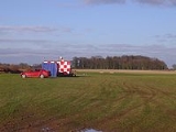
Northrepps Aerodrome is a privately owned airfield south west of the village of Northrepps
, North Norfolk
, England
approximately 3 mi (4.8 km) south south east of Cromer
. It is located next to the A149 road
close to its junction with the A 140
.
 The aerodrome is an unlicensed airfield, but light aircraft and helicopters are more than welcome to land, but with prior permission, and at the pilot’s own risk. There are several Helicopter Main Routes running close to Northrepps, (1500 ft (457.2 m) - FL60) runs north-west to south-east to the north of the airfield and HMR 7 (Helicopter Main Route) crossing the northern boundary of the airfield. There is also military and civil low level flying in the vicinity seven days a week. All aircraft should contact Coltishall
Zone during their hours of operation (closure imminent), otherwise Norwich approaches. Lower Airspace Radar
Service available from Coltishall. F/S and alerting service available from Coltishall or Anglia Radar. Circuits at 600 feet (182.9 m) above aerodrome level – left-hand for fixed wing and right-hand for helicopters.
Northrepps
Northrepps is a village and a civil parish in the English county of Norfolk. The village is southeast of Cromer, north of Norwich and north of London. The village lies west of the A149 which runs between Kings Lynn and Great Yarmouth. The nearest railway station is at Cromer for the Bittern...
, North Norfolk
North Norfolk
North Norfolk is a local government district in Norfolk, United Kingdom. Its council is based in Cromer. The council headquarters can be found approximately out of the town of Cromer on the Holt Road.-History:...
, England
England
England is a country that is part of the United Kingdom. It shares land borders with Scotland to the north and Wales to the west; the Irish Sea is to the north west, the Celtic Sea to the south west, with the North Sea to the east and the English Channel to the south separating it from continental...
approximately 3 mi (4.8 km) south south east of Cromer
Cromer
Cromer is a coastal town and civil parish in north Norfolk, England. The local government authority is North Norfolk District Council, whose headquarters is in Holt Road in the town. The town is situated 23 miles north of the county town, Norwich, and is 4 miles east of Sheringham...
. It is located next to the A149 road
A149 road
The A149 is a major route in Norfolk, linking Kings Lynn to Great Yarmouth. It runs via the coast rather than on a more direct route such as the A47. The eastern section runs through The Broads.-Kings Lynn to Wells next the Sea:...
close to its junction with the A 140
A140 road
The A140 is an 'A-class' road in Norfolk and Suffolk, East Anglia, England partly following the route of the Roman Pye Road. It runs from the A14 near Needham Market to the A149 south of Cromer. It is of primary status for the entirety of its route. It is approximately 56 miles in length...
.
History
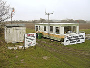
Northrepps Aerodrome opened in October 2007 following the closure of Northrepps International Airport, which was located just 1 km (0.621372736649807 mi) north west of the current aerodrome. Northrepps International Airport had just one runway (18/36) with a pronounced downslope on the southerly runway, which meant that aircraft generally took off on runway 18 and landed on runway 36 regardless of wind direction. This unusual arrangement has been the cause of some accidents, with aircraft sometimes overshooting the runway.Airfield operations
Coltishall
Coltishall is a village on the River Bure, west of Wroxham, in the English county of Norfolk, within the Norfolk Broads.Coltishall was a place of note even when the Domesday Book was compiled. For 250 years it was a centre of the malting industry...
Zone during their hours of operation (closure imminent), otherwise Norwich approaches. Lower Airspace Radar
Radar
Radar is an object-detection system which uses radio waves to determine the range, altitude, direction, or speed of objects. It can be used to detect aircraft, ships, spacecraft, guided missiles, motor vehicles, weather formations, and terrain. The radar dish or antenna transmits pulses of radio...
Service available from Coltishall. F/S and alerting service available from Coltishall or Anglia Radar. Circuits at 600 feet (182.9 m) above aerodrome level – left-hand for fixed wing and right-hand for helicopters.