
New Mexico State Road 120
Encyclopedia
State highway
State highway, state road or state route can refer to one of three related concepts, two of them related to a state or provincial government in a country that is divided into states or provinces :#A...
in the U.S. state
U.S. state
A U.S. state is any one of the 50 federated states of the United States of America that share sovereignty with the federal government. Because of this shared sovereignty, an American is a citizen both of the federal entity and of his or her state of domicile. Four states use the official title of...
of New Mexico
New Mexico
New Mexico is a state located in the southwest and western regions of the United States. New Mexico is also usually considered one of the Mountain States. With a population density of 16 per square mile, New Mexico is the sixth-most sparsely inhabited U.S...
. The route traverses four counties: Colfax
Colfax County, New Mexico
-2010:Whereas according to the 2010 U.S. Census Bureau:*83.8% White*0.5% Black*1.5% Native American*0.4% Asian*0.1% Native Hawaiian or Pacific Islander*3.6% Two or more races*10.1% Other races*47.2% Hispanic or Latino -2000:...
, Mora
Mora County, New Mexico
-2010:Whereas according to the 2010 U.S. Census Bureau:*70.9% White*0.7% Black*1.3% Native American*0.3% Asian*0.0% Native Hawaiian or Pacific Islander*3.3% Two or more races*23.5% Other races*81.0% Hispanic or Latino -2000:...
, Harding
Harding County, New Mexico
Harding County is a county located in the U.S. state of New Mexico. As of 2010, the population was 695, the lowest in the state. Its county seat is the Village of Mosquero. The county is named for United States President Warren G...
, and Union
Union County, New Mexico
-2010:Whereas according to the 2010 U.S. Census Bureau:*81.7% White*1.8% Black*2.0% Native American*0.5% Asian*0.0% Native Hawaiian or Pacific Islander*2.3% Two or more races*11.7% Other races*39.7% Hispanic or Latino -2000:...
, and is the longest state road in New Mexico. The highway's only grade-separated interchange
Interchange (road)
In the field of road transport, an interchange is a road junction that typically uses grade separation, and one or more ramps, to permit traffic on at least one highway to pass through the junction without directly crossing any other traffic stream. It differs from a standard intersection, at which...
is with Interstate 25
Interstate 25 in New Mexico
In the U.S. state of New Mexico, Interstate 25 follows the north–south corridor through Albuquerque and Santa Fe. It replaced U.S. Route 85, which is no longer signed, but still exists in route logs sharing the I-25 alignment. I-25 starts in New Mexico at an interchange with I-10 in Las Cruces and...
in Wagon Mound
Wagon Mound, New Mexico
Wagon Mound is a village in Mora County, New Mexico, United States. It is named after and located at the foot of a butte called Wagon Mound, which was a landmark for covered wagon trains and traders going up and down the Santa Fe Trail and is now Wagon Mound National Historic Landmark. The shape...
.
Route description
Starting as an unpaved road in the far southwestern corner of Colfax CountyColfax County, New Mexico
-2010:Whereas according to the 2010 U.S. Census Bureau:*83.8% White*0.5% Black*1.5% Native American*0.4% Asian*0.1% Native Hawaiian or Pacific Islander*3.6% Two or more races*10.1% Other races*47.2% Hispanic or Latino -2000:...
in the community of Black Lake at its intersection with Route 434, the road travels east around the northern edge of Ocate Mesa and then heads southeast down Manueles Canyon on the northeastern side of Ocate mesa. Due east of the top of Ocate Mesa it enters Mora County
Mora County, New Mexico
-2010:Whereas according to the 2010 U.S. Census Bureau:*70.9% White*0.7% Black*1.3% Native American*0.3% Asian*0.0% Native Hawaiian or Pacific Islander*3.3% Two or more races*23.5% Other races*81.0% Hispanic or Latino -2000:...
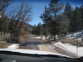
and heads south-southeast. Passing the south end of Ocate Mesa, the road heads southeast and at mile marker 12 becomes a paved road. In winter, this unpaved section is prone to heavy ice, snowpack, and mud..
After mile marker 12, the road continues southeastward passing the unpaved Los Le Febres turnoff on the right (to the west). At this point Manueles Creek on the left side of the road is joined by Wheaton Creek to form Ocate Creek, and the road follows Ocate Creek southeast with the Maxwell Land Grant on the left (NE) and the Mora Land Grant on the right (SW). The road then enters the community of Ocate where it intersects with Route 442. Leaving Ocate again along side Ocate Creek, the road heads east twisting through the foothills of Los Naranjos Peak to the south in the Ocate Creek water gap
Water gap
A water gap is an opening or notch which flowing water has carved through a mountain range. Water gaps often offer a practical route for road and rail transport to cross mountain ridges.- Geology :...
into the community of Naranjos. From Naranjos the road leaves the Ocate Creek bed and heads almost straight southeast, passing numerous ranch roads
Ranch
A ranch is an area of landscape, including various structures, given primarily to the practice of ranching, the practice of raising grazing livestock such as cattle or sheep for meat or wool. The word most often applies to livestock-raising operations in the western United States and Canada, though...
, for 19 miles (30.6 km) to the town of Wagon Mound
Wagon Mound, New Mexico
Wagon Mound is a village in Mora County, New Mexico, United States. It is named after and located at the foot of a butte called Wagon Mound, which was a landmark for covered wagon trains and traders going up and down the Santa Fe Trail and is now Wagon Mound National Historic Landmark. The shape...
. Ten miles out of Naranjos, the road passes the 7000 ft. La Chata Crater on the left (NE). Just before the town the road turns east and still on the west side of Wagon Mound, it has its only interchange
Interchange (road)
In the field of road transport, an interchange is a road junction that typically uses grade separation, and one or more ramps, to permit traffic on at least one highway to pass through the junction without directly crossing any other traffic stream. It differs from a standard intersection, at which...
at its intersection with I-25
Interstate 25
Interstate 25 is an Interstate Highway in the western United States. It is primarily a north–south highway. I-25 stretches from Interstate 10 at Las Cruces, New Mexico, , to Interstate 90 in Buffalo, Wyoming, .Interstate 25 is the main north–south expressway through...
(exit 387). The road then crosses the intercontinental railroad tracks of the BNSF Railway
BNSF Railway
The BNSF Railway is a wholly owned subsidiary of Berkshire Hathaway Inc., and is headquartered in Fort Worth, Texas. It is one of seven North American Class I railroads and the second largest freight railroad network in North America, second only to the Union Pacific Railroad, its primary...
. Within Wagon Mound the road heads east and is called Park Avenue. Leaving Wagon Mound, the road again passes numerous ranch roads heading east, past Los Mesas del Conjelon on the right (south), for about 12 miles (19.3 km) and then heading southeast another 12 miles (19.3 km) to its intersection with the Canadian River
Canadian River
The Canadian River is the longest tributary of the Arkansas River. It is about long, starting in Colorado and traveling through New Mexico, the Texas Panhandle, and most of Oklahoma....
at mile post 64. The bridge over the river is 4150 ft long.
Crossing the Canadian River bridge the road enters Harding County and then heads north-northeast about 8 miles (12.9 km) into the town of Roy
Roy, New Mexico
Roy is a village in Harding County, New Mexico, United States. The population was 304 at the 2000 census. The village has massively been losing population, but is still a major center for Northeastern New Mexico....
. The road comes into Roy as the Wagon Mound Highway, then zags up to Second Street and then up to Third Street where it intersects with Route 39. Then heading three blocks east as Third Street, the road turns due north as Floersheim Street and leaves Roy as the Yates Highway. Running along section lines the road heads north and east intermittently, passing numerous ranch roads and going through part of the Kiowa National Grassland
Kiowa National Grassland
Kiowa National Grassland is a National Grassland located in New Mexico, USA. The Great Plains grassland includes prairie and part of the Canadian River Canyon.-Sections:...
which is predominately north of the road, for 27 miles (43.5 km) to the community of Yates. Four miles later heading due north the road passes into Union County. After 12 miles (19.3 km) in Union County headed mostly north, but still on section lines, the road terminates at its intersection with U.S. Route 56
U.S. Route 56
U.S. Route 56 is an east–west United States highway that runs for in the Midwestern United States. The highway's eastern terminus is at U.S. Route 71 in Kansas City, Missouri. Its western terminus is at Interstate 25 Business in Springer, New Mexico. Much of it follows the Santa Fe...
and U.S. Route 412
U.S. Route 412
U.S. Route 412 is an east–west United States highway, first commissioned in 1982. Its route number is a "violation" of the usual AASHTO numbering scheme, as it comes nowhere near its implied "parent", US 12. U.S...
8 miles (12.9 km) east of Gladstone
Gladstone, New Mexico
Gladstone is an unincorporated community in Union County, New Mexico, founded in 1880. It lies at the intersection of US Route 56 and Union County Road C001. The post office which opened in 1888 closed in 2010.-History:...
. A dirt road continues north at that point for a couple of miles into the Don Carlos Hills.