

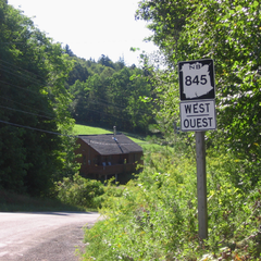
New Brunswick Route 845
Encyclopedia
Canada
Canada is a North American country consisting of ten provinces and three territories. Located in the northern part of the continent, it extends from the Atlantic Ocean in the east to the Pacific Ocean in the west, and northward into the Arctic Ocean...
highway in Kings County
Kings County, New Brunswick
Kings County is located in southern New Brunswick, Canada.Both the Saint John and Kennebecasis rivers pass through the county.Dairy farming is an important industry in the area...
, New Brunswick
New Brunswick
New Brunswick is one of Canada's three Maritime provinces and is the only province in the federation that is constitutionally bilingual . The provincial capital is Fredericton and Saint John is the most populous city. Greater Moncton is the largest Census Metropolitan Area...
.
The road passes along the southern side of the Kingston Peninsula
Kingston Peninsula
The Kingston Peninsula is a peninsula in southern New Brunswick, Canada, located between the Saint John River and the Kennebecasis River in Kings County.The peninsula was the site of the first United Empire Loyalist settlement in New Brunswick in 1783....
.
Route 845 begins within the town limits of Hampton
Hampton, New Brunswick
Hampton is a Canadian town in Kings County, New Brunswick.Located on the Kennebecasis River 30 kilometres northeast of Saint John, Hampton is the shire town of Kings County...
at an intersection with Route 121. Next comes the village of Kingston
Kingston, New Brunswick
Kingston is a rural Canadian community in Kings County, New Brunswick.Located on the Kingston Peninsula, the village was settled in 1783 by Loyalists at the conclusion of the American Revolution....
, followed by the village of Clifton Royal which has a cable ferry
Cable ferry
A cable ferry is guided and in many cases propelled across a river or other larger body of water by cables connected to both shores. They are also called chain ferries, floating bridges, or punts....
to the Saint John
Saint John, New Brunswick
City of Saint John , or commonly Saint John, is the largest city in the province of New Brunswick, and the first incorporated city in Canada. The city is situated along the north shore of the Bay of Fundy at the mouth of the Saint John River. In 2006 the city proper had a population of 74,043...
suburb of Quispamsis. Route 845 follows the southern shore of the Kingston Peninsula along the Kennebecasis River
Kennebecasis River
The Kennebecasis River is a tributary of the Saint John River in southern New Brunswick, Canada. The name Kennebecasis is thought to be derived from the Mi'kmaq "Kenepekachiachk", meaning "little long bay place." It runs for approximately 95 kilometres, draining an area in the Caledonia Highlands,...
past Clifton Royal and Chapel Grove
Chapel Grove, New Brunswick
Chapel Grove is a Canadian rural community in Kings County, New Brunswick.It is adjacent to Summerville and lies south of Clifton Royal on the Kingston Peninsula on the northwest bank of the Kennebecasis River opposite the towns of Quispamsis and Rothesay. The community is served by New Brunswick...
. Next is the community of Summerville, which has a seasonal ferry to Millidgeville
Millidgeville, New Brunswick
Millidgeville is a Canadian neighbourhood in the city of Saint John, New Brunswick.Millidgeville is situated on the northern edge of the city, on Brothers Cove off the Kennebecasis River at the point where that westerly flowing river meets the southerly flowing St. John River...
, in Saint John
Saint John, New Brunswick
City of Saint John , or commonly Saint John, is the largest city in the province of New Brunswick, and the first incorporated city in Canada. The city is situated along the north shore of the Bay of Fundy at the mouth of the Saint John River. In 2006 the city proper had a population of 74,043...
. Adjacent to this ferry is another cable ferry to Kennebecasis Island, a summer-only community accessible from May to November. The road curves northward at Lands End opposite Grand Bay-Westfield
Grand Bay-Westfield, New Brunswick
Grand Bay-Westfield is a Canadian suburban town in the western part of Kings County, New Brunswick.The town is an amalgamation of the original town of Grand Bay and the neighbouring village of Westfield immediately to the north....
, where a third ferry to Grand Bay-Westfield leaves from the Hardings Point Landing Road.
The second half of Route 845 runs northeasterly along the Saint John River from Hardings Point back to Kingston. This stretch has several river lights, beaches, and the Long Reach Volunteer Fire Department Just before the end of the highway at Kingston Corner, there is a turnoff to Route 850
New Brunswick Route 850
Route 850 is a Canadian highway in Kings County, New Brunswick.The 27 kilometre road passes along the northern side of the Kingston Peninsula.Route 850 begins near Springfield at an intersection with Route 124...
. Route 845 terminates at Kingston Corner where it meets itself, basically forming one huge rectangular loop.