
Nemaha County, Kansas
Encyclopedia
Nemaha County is a county located in the northeastern part of the U.S. state
of Kansas
. As of the 2010 census, the county population was 10,178. The county seat
is Seneca
.
measured F4 on the Fujita scale
, and had a damage path 800 yards (731.5 m) wide and 100 miles (160.9 km) long. Eighteen people were killed and sixty were injured in this tornado.
, county until the Kansas Constitution was amended in 1986 and voters approved the sale of alcoholic liquor by the individual drink with a 30% food sales requirement.
 As of the census
of 2000, there were 10,717 people, 3,959 households, and 2,763 families residing in the county. The population density
was 15 people per square mile (6/km²). There were 4,340 housing units at an average density of 6 per square mile (2/km²). The racial makeup of the county was 98.35% White
, 0.49% Black
or African American
, 0.23% Native American
, 0.10% Asian
, 0.06% Pacific Islander
, 0.17% from other races
, and 0.60% from two or more races. 0.71% of the population were Hispanic
or Latino
of any race.
There were 3,959 households out of which 34.00% had children under the age of 18 living with them, 61.90% were married couples
living together, 5.10% had a female householder with no husband present, and 30.20% were non-families. 28.00% of all households were made up of individuals and 16.00% had someone living alone who was 65 years of age or older. The average household size was 2.58 and the average family size was 3.20.
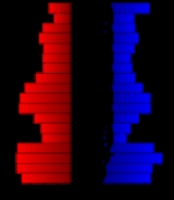
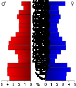
In the county the population was spread out with 28.50% under the age of 18, 6.00% from 18 to 24, 24.10% from 25 to 44, 19.40% from 45 to 64, and 22.00% who were 65 years of age or older. The median age was 39 years. For every 100 females there were 97.00 males. For every 100 females age 18 and over, there were 95.10 males.
The median income for a household in the county was $34,296, and the median income for a family was $41,838. Males had a median income of $28,879 versus $19,340 for females. The per capita income
for the county was $17,121. About 6.50% of families and 9.10% of the population were below the poverty line, including 9.90% of those under age 18 and 8.50% of those age 65 or over.
. The cities of Sabetha
and Seneca
are considered governmentally independent and are excluded from the census figures for the townships. In the following table, the population center is the largest city (or cities) included in that township's population total, if it is of a significant size.
General county information
County Level Data
Other information
Maps
U.S. state
A U.S. state is any one of the 50 federated states of the United States of America that share sovereignty with the federal government. Because of this shared sovereignty, an American is a citizen both of the federal entity and of his or her state of domicile. Four states use the official title of...
of Kansas
Kansas
Kansas is a US state located in the Midwestern United States. It is named after the Kansas River which flows through it, which in turn was named after the Kansa Native American tribe, which inhabited the area. The tribe's name is often said to mean "people of the wind" or "people of the south...
. As of the 2010 census, the county population was 10,178. The county seat
County seat
A county seat is an administrative center, or seat of government, for a county or civil parish. The term is primarily used in the United States....
is Seneca
Seneca, Kansas
Seneca is a city in and the county seat of Nemaha County, Kansas, United States. As of the 2010 census, the city population was 1,991.-History:...
.
History
On May 30, 1879, the "Irving, Kansas Tornado" passed through Nemaha county. This tornadoTornado
A tornado is a violent, dangerous, rotating column of air that is in contact with both the surface of the earth and a cumulonimbus cloud or, in rare cases, the base of a cumulus cloud. They are often referred to as a twister or a cyclone, although the word cyclone is used in meteorology in a wider...
measured F4 on the Fujita scale
Fujita scale
The Fujita scale , or Fujita-Pearson scale, is a scale for rating tornado intensity, based primarily on the damage tornadoes inflict on human-built structures and vegetation...
, and had a damage path 800 yards (731.5 m) wide and 100 miles (160.9 km) long. Eighteen people were killed and sixty were injured in this tornado.
Law and government
Nemaha County was a prohibition, or "dry"Dry county
A dry county is a county in the United States whose government forbids the sale of alcoholic beverages. Some prohibit off-premises sale, some prohibit on-premises sale, and some prohibit both. Hundreds of dry counties exist across the United States, almost all of them in the South...
, county until the Kansas Constitution was amended in 1986 and voters approved the sale of alcoholic liquor by the individual drink with a 30% food sales requirement.
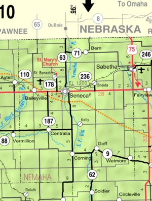
Geography
According to the 2000 census, the county has a total area of 719.4 square miles (1,863.2 km²), of which 717.99 square miles (1,859.6 km²) (or 99.80%) is land and 1.41 square miles (3.7 km²) (or 0.20%) is water.Adjacent counties
- Richardson CountyRichardson County, Nebraska-Demographics:As of the census of 2000, there were 9,531 people, 3,993 households, and 2,567 families residing in the county. The population density was 17 people per square mile . There were 4,560 housing units at an average density of 8 per square mile...
, NebraskaNebraskaNebraska is a state on the Great Plains of the Midwestern United States. The state's capital is Lincoln and its largest city is Omaha, on the Missouri River....
(northeast) - Brown CountyBrown County, KansasBrown County is a county located in Northeast Kansas, in the Central United States. As of the 2010 census, the county population was 9,984. Its county seat and most populous city is Hiawatha...
(east) - Jackson CountyJackson County, KansasJackson County is a county located in Northeast Kansas, in the Central United States. As of the 2010 census, the county population was 13,462. Its county seat and most populous city is Holton...
(southeast) - Pottawatomie CountyPottawatomie County, KansasPottawatomie County is a county located in the U.S. state of Kansas. As of the 2010 census, the county population was 21,604. The county seat is Westmoreland. The county takes its name from the Potawatomi tribe of Native Americans...
(southwest) - Marshall CountyMarshall County, KansasMarshall County is a county located in the U.S. state of Kansas. As of the 2010 census, the county population was 10,117. The largest city and county seat is Marysville.- History :...
(west) - Pawnee CountyPawnee County, Nebraska-Demographics:As of the census of 2000, there were 3,087 people, 1,339 households, and 850 families residing in the county. The population density was 7 people per square mile . There were 1,587 housing units at an average density of 4 per square mile...
, NebraskaNebraskaNebraska is a state on the Great Plains of the Midwestern United States. The state's capital is Lincoln and its largest city is Omaha, on the Missouri River....
(northwest)
Demographics
Census
A census is the procedure of systematically acquiring and recording information about the members of a given population. It is a regularly occurring and official count of a particular population. The term is used mostly in connection with national population and housing censuses; other common...
of 2000, there were 10,717 people, 3,959 households, and 2,763 families residing in the county. The population density
Population density
Population density is a measurement of population per unit area or unit volume. It is frequently applied to living organisms, and particularly to humans...
was 15 people per square mile (6/km²). There were 4,340 housing units at an average density of 6 per square mile (2/km²). The racial makeup of the county was 98.35% White
Race (United States Census)
Race and ethnicity in the United States Census, as defined by the Federal Office of Management and Budget and the United States Census Bureau, are self-identification data items in which residents choose the race or races with which they most closely identify, and indicate whether or not they are...
, 0.49% Black
Race (United States Census)
Race and ethnicity in the United States Census, as defined by the Federal Office of Management and Budget and the United States Census Bureau, are self-identification data items in which residents choose the race or races with which they most closely identify, and indicate whether or not they are...
or African American
Race (United States Census)
Race and ethnicity in the United States Census, as defined by the Federal Office of Management and Budget and the United States Census Bureau, are self-identification data items in which residents choose the race or races with which they most closely identify, and indicate whether or not they are...
, 0.23% Native American
Race (United States Census)
Race and ethnicity in the United States Census, as defined by the Federal Office of Management and Budget and the United States Census Bureau, are self-identification data items in which residents choose the race or races with which they most closely identify, and indicate whether or not they are...
, 0.10% Asian
Race (United States Census)
Race and ethnicity in the United States Census, as defined by the Federal Office of Management and Budget and the United States Census Bureau, are self-identification data items in which residents choose the race or races with which they most closely identify, and indicate whether or not they are...
, 0.06% Pacific Islander
Race (United States Census)
Race and ethnicity in the United States Census, as defined by the Federal Office of Management and Budget and the United States Census Bureau, are self-identification data items in which residents choose the race or races with which they most closely identify, and indicate whether or not they are...
, 0.17% from other races
Race (United States Census)
Race and ethnicity in the United States Census, as defined by the Federal Office of Management and Budget and the United States Census Bureau, are self-identification data items in which residents choose the race or races with which they most closely identify, and indicate whether or not they are...
, and 0.60% from two or more races. 0.71% of the population were Hispanic
Race (United States Census)
Race and ethnicity in the United States Census, as defined by the Federal Office of Management and Budget and the United States Census Bureau, are self-identification data items in which residents choose the race or races with which they most closely identify, and indicate whether or not they are...
or Latino
Race (United States Census)
Race and ethnicity in the United States Census, as defined by the Federal Office of Management and Budget and the United States Census Bureau, are self-identification data items in which residents choose the race or races with which they most closely identify, and indicate whether or not they are...
of any race.
There were 3,959 households out of which 34.00% had children under the age of 18 living with them, 61.90% were married couples
Marriage
Marriage is a social union or legal contract between people that creates kinship. It is an institution in which interpersonal relationships, usually intimate and sexual, are acknowledged in a variety of ways, depending on the culture or subculture in which it is found...
living together, 5.10% had a female householder with no husband present, and 30.20% were non-families. 28.00% of all households were made up of individuals and 16.00% had someone living alone who was 65 years of age or older. The average household size was 2.58 and the average family size was 3.20.
In the county the population was spread out with 28.50% under the age of 18, 6.00% from 18 to 24, 24.10% from 25 to 44, 19.40% from 45 to 64, and 22.00% who were 65 years of age or older. The median age was 39 years. For every 100 females there were 97.00 males. For every 100 females age 18 and over, there were 95.10 males.
The median income for a household in the county was $34,296, and the median income for a family was $41,838. Males had a median income of $28,879 versus $19,340 for females. The per capita income
Per capita income
Per capita income or income per person is a measure of mean income within an economic aggregate, such as a country or city. It is calculated by taking a measure of all sources of income in the aggregate and dividing it by the total population...
for the county was $17,121. About 6.50% of families and 9.10% of the population were below the poverty line, including 9.90% of those under age 18 and 8.50% of those age 65 or over.
Incorporated cities
Name and population (2004 estimate):- SabethaSabetha, KansasSabetha is a city in Brown and Nemaha counties in the U.S. state of Kansas. As of the 2010 census, the city population was 2,571.- History :The town's settlement began circa 1854, with a name reportedly derived from the word Sabbath, the day the first settler arrived.On the evening of June 13,...
, 2,532, of which a small portion lies in Brown CountyBrown County, KansasBrown County is a county located in Northeast Kansas, in the Central United States. As of the 2010 census, the county population was 9,984. Its county seat and most populous city is Hiawatha... - SenecaSeneca, KansasSeneca is a city in and the county seat of Nemaha County, Kansas, United States. As of the 2010 census, the city population was 1,991.-History:...
, 2,072 - CentraliaCentralia, KansasCentralia is a city in Nemaha County, Kansas, in the United States. As of the 2010 census, the city population was 512.-Geography:Centralia is located at...
, 507 - WetmoreWetmore, KansasWetmore is a city in Nemaha County, Kansas, United States. As of the 2010 census, the city population was 368.-Geography:Wetmore is located at . According to the United States Census Bureau, the city has a total area of , all of it land.-Demographics:As of the census of 2000, there were 362...
, 356 - BernBern, KansasBern is a city in Nemaha County, Kansas, United States. As of the 2010 census, the city population was 166.-Geography:Bern is located at . According to the United States Census Bureau, the city has a total area of , all of it land....
, 200 - GoffGoff, KansasGoff is a city in Nemaha County, Kansas, United States. Goff was named for Edward H. Goff, railroad official. As of the 2010 census, the city population was 126.-Geography:Goff is located at...
, 177 - CorningCorning, KansasCorning is a city in Nemaha County, Kansas, United States. As of the 2010 census, the city population was 157.-Geography:Corning is located at . According to the United States Census Bureau, the city has a total area of , all of it land.-Demographics:As of the census of 2000, there were 170...
, 167 - OneidaOneida, KansasOneida is a city in Nemaha County, Kansas, United States. As of the 2010 census, the city population was 75.-Geography:Oneida is located at . According to the United States Census Bureau, the city has a total area of , all of it land.-Demographics:As of the census of 2000, there were 70 people,...
, 69
Unincorporated places
- BaileyvilleBaileyville, KansasBaileyville is an unincorporated community in western Nemaha County, Kansas, United States. It is located six miles west of Seneca on U.S. Route 36.-History:...
- Kelly
- St. Benedict
Townships
Nemaha County is divided into twenty townshipsCivil township
A civil township is a widely used unit of local government in the United States, subordinate to, and geographic divisions of, a county. Specific responsibilities and the degree of autonomy vary based on each state. Civil townships are distinct from survey townships, but in states that have both,...
. The cities of Sabetha
Sabetha, Kansas
Sabetha is a city in Brown and Nemaha counties in the U.S. state of Kansas. As of the 2010 census, the city population was 2,571.- History :The town's settlement began circa 1854, with a name reportedly derived from the word Sabbath, the day the first settler arrived.On the evening of June 13,...
and Seneca
Seneca, Kansas
Seneca is a city in and the county seat of Nemaha County, Kansas, United States. As of the 2010 census, the city population was 1,991.-History:...
are considered governmentally independent and are excluded from the census figures for the townships. In the following table, the population center is the largest city (or cities) included in that township's population total, if it is of a significant size.
| Township | FIPS | Population center |
Population | Population density /km² (/sq mi) |
Land area km² (sq mi) | Water area km² (sq mi) | Water % | Geographic coordinates |
|---|---|---|---|---|---|---|---|---|
| Adams Adams Township, Kansas Adams Township is a township in Nemaha County, Kansas, United States.... |
00275 | 213 | 2 (6) | 93 (36) | 0 (0) | 0.03% | 39°46′38"N 95°57′36"W | |
| Berwick | 06375 | 391 | 4 (11) | 93 (36) | 0 (0) | 0.02% | 39°57′11"N 95°50′11"W | |
| Capioma | 10575 | 161 | 2 (4) | 93 (36) | 0 (0) | 0.03% | 39°47′28"N 95°51′18"W | |
| Center | 11900 | 200 | 2 (6) | 94 (36) | 0 (0) | 0 % | 39°46′37"N 96°11′15"W | |
| Clear Creek | 13775 | 123 | 1 (3) | 93 (36) | 0 (0) | 0 % | 39°57′27"N 96°10′56"W | |
| Gilman | 26275 | 223 | 2 (6) | 93 (36) | 0 (0) | 0.19% | 39°52′1"N 95°57′14"W | |
| Granada | 27275 | 122 | 1 (3) | 93 (36) | 0 (0) | 0.06% | 39°41′23"N 95°51′10"W | |
| Harrison | 30375 | 399 | 4 (11) | 93 (36) | 0 (0) | 0.06% | 39°41′22"N 95°56′55"W | |
| Home | 32900 | 567 | 6 (16) | 91 (35) | 3 (1) | 3.12% | 39°42′36"N 96°9′17"W | |
| Illinois | 33725 | 453 | 5 (13) | 93 (36) | 0 (0) | 0 % | 39°41′13"N 96°3′41"W | |
| Marion | 44775 | 457 | 5 (13) | 94 (36) | 0 (0) | 0.02% | 39°51′48"N 96°11′32"W | |
| Mitchell | 47475 | 305 | 3 (9) | 93 (36) | 0 (0) | 0 % | 39°47′25"N 96°3′43"W | |
| Nemaha | 49625 | 184 | 2 (5) | 92 (35) | 0 (0) | 0 % | 39°57′4"N 96°3′44"W | |
| Neuchatel | 50050 | 117 | 1 (3) | 94 (36) | 0 (0) | 0 % | 39°36′27"N 96°11′25"W | |
| Red Vermillion | 58750 | 137 | 1 (4) | 93 (36) | 0 (0) | 0.02% | 39°36′17"N 96°4′0"W | |
| Reilly | 58900 | 153 | 2 (4) | 93 (36) | 0 (0) | 0.07% | 39°36′47"N 95°57′12"W | |
| Richmond | 59725 | 538 | 6 (16) | 89 (34) | 0 (0) | 0 % | 39°51′34"N 96°3′49"W | |
| Rock Creek | 60600 | 302 | 3 (9) | 88 (34) | 0 (0) | 0.28% | 39°52′32"N 95°50′8"W | |
| Washington | 75675 | 465 | 5 (13) | 93 (36) | 0 (0) | 0.01% | 39°57′41"N 95°57′44"W | |
| Wetmore | 77575 | 503 | 5 (14) | 93 (36) | 0 (0) | 0.02% | 39°37′35"N 95°49′43"W |
Education
Unified school districts
- Sabetha USD 441
- Nemaha Valley USD 442
- B & B USD 451
- Centralia USD 380
See also
- National Register of Historic Places listings in Nemaha County, KansasNational Register of Historic Places listings in Nemaha County, KansasThis is a list of the National Register of Historic Places listings in Nemaha County, Kansas.This is intended to be a complete list of the properties and districts on the National Register of Historic Places in Nemaha County, Kansas, United States...
Further reading
- History of the State of Kansas; William G. Cutler; A.T. Andreas Publisher; 1883. (Online HTML eBook)
- Kansas : A Cyclopedia of State History, Embracing Events, Institutions, Industries, Counties, Cities, Towns, Prominent Persons, Etc; 3 Volumes; Frank W. Blackmar; Standard Publishing Co; 944 / 955 / 824 pages; 1912. (Volume1 - Download 54MB PDF eBook),(Volume2 - Download 53MB PDF eBook), (Volume3 - Download 33MB PDF eBook)
External links
OfficialGeneral county information
County Level Data
Other information
- http://www.kansas.net/~rjherman/Irving,%20Kansas%20Tornado.htm - The Irving, KS Tornado
- http://web.archive.org/web/20050904090010/http://www.geocities.com/joefurr2/histtor.html - Historical Tornadoes
Maps
- 2010 Nemaha County Map, KDOT
- 2011 Kansas Highway Map, KDOT
- 2011 Kansas Railroad Map, KDOT
- 2005 Kansas School District Boundary Map, KSDE