
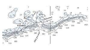
Nell Island
Encyclopedia
Kwajalein
Kwajalein Atoll , is part of the Republic of the Marshall Islands . The southernmost and largest island in the atoll is named Kwajalein Island. English-speaking residents of the U.S...
Atoll in the Ralik Chain
Ralik Chain
The Ralik Chain is a chain of islands within the island nation of the Marshall Islands. Ralik means "sunset". It lies just to the west of the country's other island chain, the Ratak Chain...
in the Republic of the Marshall Islands
Marshall Islands
The Republic of the Marshall Islands , , is a Micronesian nation of atolls and islands in the middle of the Pacific Ocean, just west of the International Date Line and just north of the Equator. As of July 2011 the population was 67,182...
(RMI), 2,100 nautical miles (3900 km) southwest of Honolulu, Hawaii
Honolulu, Hawaii
Honolulu is the capital and the most populous city of the U.S. state of Hawaii. Honolulu is the southernmost major U.S. city. Although the name "Honolulu" refers to the urban area on the southeastern shore of the island of Oahu, the city and county government are consolidated as the City and...
. It lies at a convergence of deep, narrow, protected channels and small islands. This area was the traditional seat of power for the Iroij (High Chiefs) at Kwajalein, prior to foreign occupation and population displacement.
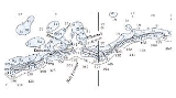
Nel(Nōl) is part of a group of four islands - including Enmaat, Pikon-Nōl and Anē-Ruo - with special historical importance in Marshallese culture. Marshallese consider these islands some of the most sacred or "mo" (tabu) islands in Kwajalein Atoll. Enmaat was the residence of the high chiefs' families. Traditional Marshallese cultural leadership http://www.prel.org/products/paced/apr04/re_colonial.htm and land-ownership for these islands resides with the Kabua family. According to Ato Langio, a Marshallese elder, the area just inside Enmaat - protected by Enmaat, Anē-ruo, Nōl and Pikon-Nōl - is one of the most protected canoe anchorages in the atoll. Early Marshallese cultures relied heavily on their expert navigation skills, their skill in building and sailing the large (up to 100') ocean-going outrigger canoes http://www.wingo.com/proa/micronesia/marshall_isles_proas.html known as Proa
Proa
A proa, also seen as prau, perahu, and prahu, is a type of multihull sailing vessel.While the word perahu and proa are generic terms meaning boat their native language, proa in Western languages has come to describe a vessel consisting of two unequal length parallel hulls...
and on the unique Marshall Islands stick chart
Marshall Islands stick chart
Stick charts were made and used by the Marshallese to navigate the Pacific Ocean by canoe off the coast of the Marshall Islands. The charts represented major ocean swell patterns and the ways the islands disrupted those patterns, typically determined by sensing disruptions in ocean swells by...
as a means of navigational documentation. The Nel area was called "mien wa" (sheltered haven for canoes for the chief), and protected by "Limejwa", a Marshallese idol. With wistful sadness modern day Marshallese relate how children could cross the channel with immunity protected by "Limejwa" using coconuts for floatation. Pacific cultures anthropologist Dr. Larry Carucci http://www.montana.edu/wwwcat/faculty/AcadFac.html#C did extensive research on the cultural significance of sites in Kwajalein Atoll. He explains that the Nel area is especially significant because the Iroij and Leiroj lived there and also because the island of Anē-ruo was "uliej", the graveyard or cemetery of high chiefs. To this day, out of respect and a sense of "mo" many Marshallese transiting the area stop across the channel from Nōl - on Enmaat - and do not make landfall on Nōl.
These islands fall within the "mid-atoll corridor" which was evacuated in 1965 to establish a safe area for ICBM testing (NIke X program) when Kwajalein Atoll was part of the United Nations Trust Territories
United Nations Trust Territories
United Nations trust territories were the successors of the remaining League of Nations mandates and came into being when the League of Nations ceased to exist in 1946. All of the trust territories were administered through the UN Trusteeship Council...
. The residents were moved to Ebeye
Ebeye
Ebeye is the most populous island of Kwajalein Atoll in the Marshall Islands, as well as the center for Marshallese culture in the Ralik Chain of the archipelago. Settled on 80 acres of land, it has a population of more than 15,000. Over 50% of the population is estimated to be under the age of...
where they remain up to this day under terms of a Compact of Free Association
Compact of Free Association
The Compact of Free Association defines the relationship that three sovereign states—the Federated States of Micronesia , the Republic of the Marshall Islands and the Republic of Palau—have entered into as associated states with the United States.Now sovereign nations, the three freely associated...
http://www.publicanthropology.org/Journals/Grad-j/Hawaii/Walsh.htm.
There's confusion within the non-native population at Kwajalein regarding just which island here is Nel. Many refer to the group of four islands - Nel, Enmaat, Pikon-Nōl, Ane-ruo - as Nel. Nel Island is the larger, longer island east of the chiefs' island and Nel Pass, but recent residents of the Atoll have come to refer to the smaller Anē-Ruo(Enero) island as Nel. This small (1/8 x 1/4 mi) island - the "king's island" - lies lagoon-side of Enmaat and west of Nel Pass. This is the "Nell" that is destination for many current visitors to the area while Nel itself is the much larger (1/8 x 3.5 mi) island east of Nel pass.