
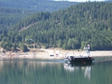
Needles ferry
Encyclopedia

Cable ferry
A cable ferry is guided and in many cases propelled across a river or other larger body of water by cables connected to both shores. They are also called chain ferries, floating bridges, or punts....
across Lower Arrow Lake in British Columbia
British Columbia
British Columbia is the westernmost of Canada's provinces and is known for its natural beauty, as reflected in its Latin motto, Splendor sine occasu . Its name was chosen by Queen Victoria in 1858...
, Canada
Canada
Canada is a North American country consisting of ten provinces and three territories. Located in the northern part of the continent, it extends from the Atlantic Ocean in the east to the Pacific Ocean in the west, and northward into the Arctic Ocean...
. It is situated 59 kilometres (36.7 mi) south of Nakusp
Nakusp, British Columbia
The Village of Nakusp is a small community located on the shores of Upper Arrow Lake, a portion of the Columbia River, in the West Kootenay region of British Columbia...
and links Needles and Fauquier
Fauquier, British Columbia
Fauquier is a settlement in British Columbia. It is located on the east side of Lower Arrow Lake along Highway 6, where a car ferry links to the west side of the lake....
.
Operation
The ferry operates under contract to the British Columbia Ministry of TransportationBritish Columbia Ministry of Transportation
The British Columbia Ministry of Transportation and Infrastructure is the British Columbia government ministry responsible for transport infrastructure and law in the Canadian province of British Columbia...
and is free of tolls. It travels back and forth every thirty minutes, from the first departure at 5am until the last departure at 10pm, with a crossing time of about five minutes. The ferry has capacity for 30 vehicles and 144 passengers.
The ferry is diesel powered and pulls using a winding drum on a pair of 1 inches (25.4 mm) cables, plastic coated to prevent wear, which are suspended in the lake. The crossing is about 1 kilometre (0.621372736649807 mi) in length.
History
A ferry has been in operation from Needles since 1913. Early farmers built the first ferry using Ford Model TFord Model T
The Ford Model T is an automobile that was produced by Henry Ford's Ford Motor Company from September 1908 to May 1927...
parts. A small community in Needles, which pre-dated the ferry, was an area of fruit trees and scrub farming. Farmers provided fruit and vegetables to the mines of the Lardeau
Lardeau
Lardeau, originally spelled Lardo, is an unincorporated community and former mining town near the north end of Kootenay Lake in the West Kootenay region of southeastern British Columbia, Canada...
district (between Upper Arrow Lake and the head of Kootenay Lake). Canadian Pacific Railway
Canadian Pacific Railway
The Canadian Pacific Railway , formerly also known as CP Rail between 1968 and 1996, is a historic Canadian Class I railway founded in 1881 and now operated by Canadian Pacific Railway Limited, which began operations as legal owner in a corporate restructuring in 2001...
lake steamers connected the farms to Arrowhead and Robson. The valley was flooded in the late 1960s by the construction of the Hugh Keenleyside Dam at Castlegar
Castlegar, British Columbia
Castlegar is the second largest city in the West Kootenay region of British Columbia, Canada. It is located within the Selkirk Mountains at the confluence of the Kootenay and Columbia Rivers. It is a regional trade and transportation centre, with a local economy fueled by forestry, mining and tourism...
in the 1960s, leading people to abandon the town, after being expropriated from the lakeshore by Hydro. The ferry landing and a small cemetery are all that remain.
Fauquier is the "centre" of the area that includes Edgewood
Edgewood, British Columbia
Edgewood is a settlement in British Columbia. It is located on the western shore of Arrow Lake.In 2008, there was a 181-hectare forest fire just outside of Edgewood....
and Burton
Burton, British Columbia
Burton is a settlement on the Arrow Lakes in the West Kootenay region of southeastern British Columbia, Canada.Before european contact, Burton was known as xaieken , a large village of Sinixt first nations people. Burton came to be in the 1890's when gold was found at Cariboo Creek, a steamboat...
with a few houses, gas station and grocery store.
External links
- Needles Ferry Schedule at the BC Ministry of Transportation
- Needles Ferry Crossing at WikimapiaWikimapiaWikiMapia is a privately owned, online map and satellite imaging resource that combines Google Maps with a wiki system, allowing users to add information, in the form of a note, to any location on Earth. Users may currently use this information for free...