
Wikimapia
Encyclopedia
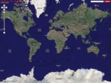
WikiMapia is a privately owned, online map
and satellite imaging resource that combines Google Maps
with a wiki
system, allowing users to add information, in the form of a note, to any location on Earth
. Users may currently use this information for free. Inspired by the success of Google Maps
and Wikipedia
, two Russian Internet entrepreneurs Alexandre Koriakine and Evgeniy Saveliev launched the website on May 24, 2006. Its aim is to "describe the whole world". It now has over 15,000,000 places marked. Although registration is not required to edit or add to WikiMapia, over 1,100,000 users from around the world currently are registered.
All content uploaded by users is currently made available under Creative Commons license for non-commercial use through WikiMapia API.
Approximately 1,000 new users register everyday.
around the location and then providing a default language, title, description and one or more categories. An optional note can be provided, as well as images and embedded YouTube
videos, which all appear on the place's information window.
Multiple categories can be added to any placemark by clicking the add category link and either selecting from a list of common categories, or by typing in the first few letters of the word to search for a category. The numbers displayed in parentheses next to each category indicate the number of placemarks belonging to that category. Basic functions also allow users to link to a corresponding Wikipedia
article, add an address, or specify whether a polygon
outlines a building (as opposed to a parcel of land).
or the Internet
.
) use ISO 639-1
naming conventions. Registered users can help translate the WikiMapia interface at a special page.
lines, and rivers. The interface allows users to specify the size of the road (major highway, side street, dirt road, etc.), to indicate one-way streets, and to provide a brief description. It also allows users to describe intersections and tunnels.
The railroad and ferry line interfaces are similar to the one used for roads. The river-marking tool is somewhat more complex, as there are secondary lines that can be used to define the river's shoreline.
The roads feature is also used to populate a drop-down list of nearby street names in a tag's address box.
As of February 2011, WikiMapia collectively contains over 6,000,000 km of roads, over 2,500,000 km of rivers, over 1,300,000 km of railways and over 450,000 km of ferry routes.
through the API.
Because the WikiMapia's geo-located data is all built based on aerial imagery from Google Maps, the dataset (and any further derivations from it) may attract copyright as a "derived work". This will depend on jurisdiction, and generally is an unclear area of copyright law, but the principle allows aerial photography companies to license (at great expense) the right to derive geo-data from their imagery. Although Google have not been known to sue for copyright violation in the courts over use of aerial imagery, their terms of service do include provisions regarding their rights over derived data. The approach taken by WikiMapia is in contrast with a more clean-room "from scratch" re-mapping approach as followed by the OpenStreetMap
project.
Map
A map is a visual representation of an area—a symbolic depiction highlighting relationships between elements of that space such as objects, regions, and themes....
and satellite imaging resource that combines Google Maps
Google Maps
Google Maps is a web mapping service application and technology provided by Google, free , that powers many map-based services, including the Google Maps website, Google Ride Finder, Google Transit, and maps embedded on third-party websites via the Google Maps API...
with a wiki
Wiki
A wiki is a website that allows the creation and editing of any number of interlinked web pages via a web browser using a simplified markup language or a WYSIWYG text editor. Wikis are typically powered by wiki software and are often used collaboratively by multiple users. Examples include...
system, allowing users to add information, in the form of a note, to any location on Earth
Earth
Earth is the third planet from the Sun, and the densest and fifth-largest of the eight planets in the Solar System. It is also the largest of the Solar System's four terrestrial planets...
. Users may currently use this information for free. Inspired by the success of Google Maps
Google Maps
Google Maps is a web mapping service application and technology provided by Google, free , that powers many map-based services, including the Google Maps website, Google Ride Finder, Google Transit, and maps embedded on third-party websites via the Google Maps API...
and Wikipedia
Wikipedia
Wikipedia is a free, web-based, collaborative, multilingual encyclopedia project supported by the non-profit Wikimedia Foundation. Its 20 million articles have been written collaboratively by volunteers around the world. Almost all of its articles can be edited by anyone with access to the site,...
, two Russian Internet entrepreneurs Alexandre Koriakine and Evgeniy Saveliev launched the website on May 24, 2006. Its aim is to "describe the whole world". It now has over 15,000,000 places marked. Although registration is not required to edit or add to WikiMapia, over 1,100,000 users from around the world currently are registered.
All content uploaded by users is currently made available under Creative Commons license for non-commercial use through WikiMapia API.
Approximately 1,000 new users register everyday.
Features
WikiMapia allows any contributor to add a "tag" (placemark) to any location by marking out a polygonPolygon
In geometry a polygon is a flat shape consisting of straight lines that are joined to form a closed chain orcircuit.A polygon is traditionally a plane figure that is bounded by a closed path, composed of a finite sequence of straight line segments...
around the location and then providing a default language, title, description and one or more categories. An optional note can be provided, as well as images and embedded YouTube
YouTube
YouTube is a video-sharing website, created by three former PayPal employees in February 2005, on which users can upload, view and share videos....
videos, which all appear on the place's information window.
Multiple categories can be added to any placemark by clicking the add category link and either selecting from a list of common categories, or by typing in the first few letters of the word to search for a category. The numbers displayed in parentheses next to each category indicate the number of placemarks belonging to that category. Basic functions also allow users to link to a corresponding Wikipedia
Wikipedia
Wikipedia is a free, web-based, collaborative, multilingual encyclopedia project supported by the non-profit Wikimedia Foundation. Its 20 million articles have been written collaboratively by volunteers around the world. Almost all of its articles can be edited by anyone with access to the site,...
article, add an address, or specify whether a polygon
Polygon
In geometry a polygon is a flat shape consisting of straight lines that are joined to form a closed chain orcircuit.A polygon is traditionally a plane figure that is bounded by a closed path, composed of a finite sequence of straight line segments...
outlines a building (as opposed to a parcel of land).
Pictures
Users also can add up to seven pictures to each tag by selecting Add/Manage Photos from the placetag's menu. This opens a dialog box, allowing the user to upload a photo from their computerComputer
A computer is a programmable machine designed to sequentially and automatically carry out a sequence of arithmetic or logical operations. The particular sequence of operations can be changed readily, allowing the computer to solve more than one kind of problem...
or the Internet
Internet
The Internet is a global system of interconnected computer networks that use the standard Internet protocol suite to serve billions of users worldwide...
.
Languages
Location tagging is fully multi-lingual, meaning that there is no need to create separate tags for different languages. If a place is described in multiple languages, the user can navigate to other language pages by clicking on the link at the bottom of the window. Currently a total of 101 languages are supported, and 100% of the interface has been translated into 56 languages. Most of the languages (except ChineseChinese language
The Chinese language is a language or language family consisting of varieties which are mutually intelligible to varying degrees. Originally the indigenous languages spoken by the Han Chinese in China, it forms one of the branches of Sino-Tibetan family of languages...
) use ISO 639-1
ISO 639-1
ISO 639-1:2002, Codes for the representation of names of languages — Part 1: Alpha-2 code, is the first part of the ISO 639 series of international standards for language codes. Part 1 covers the registration of two-letter codes. There are 136 two-letter codes registered...
naming conventions. Registered users can help translate the WikiMapia interface at a special page.
Linear features
WikiMapia also allows users to add "linear features", meaning roads, railroads, ferryFerry
A ferry is a form of transportation, usually a boat, but sometimes a ship, used to carry primarily passengers, and sometimes vehicles and cargo as well, across a body of water. Most ferries operate on regular, frequent, return services...
lines, and rivers. The interface allows users to specify the size of the road (major highway, side street, dirt road, etc.), to indicate one-way streets, and to provide a brief description. It also allows users to describe intersections and tunnels.
The railroad and ferry line interfaces are similar to the one used for roads. The river-marking tool is somewhat more complex, as there are secondary lines that can be used to define the river's shoreline.
The roads feature is also used to populate a drop-down list of nearby street names in a tag's address box.
As of February 2011, WikiMapia collectively contains over 6,000,000 km of roads, over 2,500,000 km of rivers, over 1,300,000 km of railways and over 450,000 km of ferry routes.
Watchlists
WikiMapia also allows registered users to set up watchlists to monitor changes on certain areas of the map. Users can define the size and location of each watched region and save it under a unique name.WikiMapia forum
In addition to the Messaging system, which runs from the map screen, WikiMapia also operates a forum, which was launched in October 2007. Although a separate wiki user guide exists, most of WikiMapia's policy discussions take place at the forum.User accounts and levels
Optional user accounts were introduced in October 2006. User levels and permissions have evolved over time in response to the need to control vandalism or abuse. As explained in the WikiMapia FAQ, there are three user-levels.- User Level 0 (UL0): Level 0 is the default user level assigned to all new users. UL0 are able to add places, edit existing places, and use the personal messaging system. New users are temporarily prevented from posting in the forum.
- User Level 1 (UL1): Users are automatically upgraded to UL1 after a few days. In addition to the regular UL0 functions, UL1 users are able to change polygons (place outlines), add roads, add rivers, add railroads, delete places, and contribute to the forum. The vast majority of WikiMapia contributors fall into this category.
- Advanced User (Formerly UL2): A few hundred registered WikiMapia users have been granted advanced access. Advanced User permissions include functions which are vital to maintaining site security (such as the ability to initiate ban proceedings on vandals) and anti-vandalism efforts on the map itself (such as the ability to delete a greater number of tags, to protect tags against editing by unregistered users, and to quick-delete certain tags).
Advanced User status
Advanced User status may be one of the most misunderstood aspects of WikiMapia's hierarchy, in part, because the process of promotion remains mysterious to most new users. Advanced User permissions are granted solely at the discretion of WikiMapia Administrators (or site owners), and have been revoked in a few instances. Although WikiMapia Administrators have historically taken recommendations by senior users into account when promoting new users, they have also occasionally acted unilaterally to demote Advanced users.Clutter and filtering
In some areas of the world with out-of-date or very expensive mapping, such as in the case of developing countries, WikiMapia growth has been phenomenally rapid. This rapid growth brought problems of its own, however. Urban areas became covered with thousands of overlapping rectangles marking the positions of private residences, but there was no provision in the WikiMapia interface for distinguishing those residences from places of public interest.Licensing
December 2010 WikiMapia announced that all the content is now available under Creative Commons licence 3.0(by-nc-sa)Creative Commons licenses
Creative Commons licenses are several copyright licenses that allow the distribution of copyrighted works. The licenses differ by several combinations that condition the terms of distribution. They were initially released on December 16, 2002 by Creative Commons, a U.S...
through the API.
Because the WikiMapia's geo-located data is all built based on aerial imagery from Google Maps, the dataset (and any further derivations from it) may attract copyright as a "derived work". This will depend on jurisdiction, and generally is an unclear area of copyright law, but the principle allows aerial photography companies to license (at great expense) the right to derive geo-data from their imagery. Although Google have not been known to sue for copyright violation in the courts over use of aerial imagery, their terms of service do include provisions regarding their rights over derived data. The approach taken by WikiMapia is in contrast with a more clean-room "from scratch" re-mapping approach as followed by the OpenStreetMap
OpenStreetMap
OpenStreetMap is a collaborative project to create a free editable map of the world. Two major driving forces behind the establishment and growth of OSM have been restrictions on use or availability of map information across much of the world and the advent of inexpensive portable GPS devices.The...
project.
Interoperability
Limited WikiMapia functionality is available on:- Google EarthGoogle EarthGoogle Earth is a virtual globe, map and geographical information program that was originally called EarthViewer 3D, and was created by Keyhole, Inc, a Central Intelligence Agency funded company acquired by Google in 2004 . It maps the Earth by the superimposition of images obtained from satellite...
, using Google Earth dynamic layer in KML file. - Any HTML webpage, using code for a map frame which can be found on the top menu, under "WikiMapia:Map on your page"
- Most Java-enabled cellphones using 3rd party software such as Mobile GMaps.
- iPhoneIPhoneThe iPhone is a line of Internet and multimedia-enabled smartphones marketed by Apple Inc. The first iPhone was unveiled by Steve Jobs, then CEO of Apple, on January 9, 2007, and released on June 29, 2007...
application.
See also
- BhuvanBhuvanBhuvan, , is a software application which allows users to explore a 3D representation of the surface of the Earth. The browser is specifically tailored to view India, offering the highest resolution in this region. A beta version was launched on 12 August 2009.- Overview :ISRO launched the beta...
- Collaborative mappingCollaborative mappingCollaborative mapping is the aggregation of web maps and user-generated content, from a group of individuals or entities, and can take several distinct forms.-Types:...
- Google EarthGoogle EarthGoogle Earth is a virtual globe, map and geographical information program that was originally called EarthViewer 3D, and was created by Keyhole, Inc, a Central Intelligence Agency funded company acquired by Google in 2004 . It maps the Earth by the superimposition of images obtained from satellite...
- Google Map MakerGoogle Map MakerGoogle Map Maker is a service launched by Google in June 2008, designed to expand the breadth of the service currently offered by Google Maps. In some countries mapping data is unavailable, and so to combat this problem Google has decided to open up Google Maps to a collaborative community effort...
- List of GPS Software for Mobile Phones
- List of wikis
- OpenStreetMapOpenStreetMapOpenStreetMap is a collaborative project to create a free editable map of the world. Two major driving forces behind the establishment and growth of OSM have been restrictions on use or availability of map information across much of the world and the advent of inexpensive portable GPS devices.The...
- Participatory GISParticipatory GISAs defined by the participants in the Mapping for Change International Conference which took place in Nairobi, Kenya in September 2005, Participatory GIS is an emergent practice in its own right; developing out of participatory approaches to planning and spatial information and communication...
- PlaceopediaPlaceopediaPlaceopedia was an online gazetteer which integrates Google Maps images and Wikipedia encyclopedia articles using user-generated content...
- Public Participation GISPublic Participation GISPublic participation geographic information systems was born, as a term, in 1996 at the meetings of the National Center for Geographic Information and Analysis . PPGIS is meant to bring the academic practices of GIS and mapping to the local level in order to promote knowledge production...
External links
- Official WikiMapia Blog
- WikiMapia Terms of Reference
- WikiMapia Forum for discussions
- WikiMapia API
- WikiMapia Full User Guide
- Wikimapia Wiki
- WikiMapia UserScript add-on for FireFox, Opera and Google Chrome
- Matt Jones' WikiMapia Blog
- Meta.Wikimedia/about the connection with Wikipedia
- 'Borderless' - WikiMapia Anthem
- Приложение для iPadIPadThe iPad is a line of tablet computers designed, developed and marketed by Apple Inc., primarily as a platform for audio-visual media including books, periodicals, movies, music, games, and web content. The iPad was introduced on January 27, 2010 by Apple's then-CEO Steve Jobs. Its size and...
- WikiMapia - Как использовать в GPS Garmin векторные объекты WikiMapia