

National Weather Service Lincoln, Illinois
Encyclopedia
National Weather Service Lincoln, Illinois also known as National Weather Service Central Illinois is a weather forecast office responsible for monitoring weather conditions for 35 counties in Central
and Southeastern Illinois
. The Central Illinois office initially consisted of two forecast offices in Peoria
and Springfield
until the current location in Lincoln
became the sole local forecast office in 1995. Federal meteorology offices and stations in the region date back to the 19th century when the Army Signal Service began taking weather observations using weather equipment at the Springer Building in Springfield
. Since that time the presence of the National Weather Service
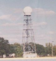
greatly increased with the instillation of new weather radars, stations and forecast offices. The current office in Lincoln maintains a WSR-88D (NEXRAD) radar system, and Advanced Weather Interactive Processing System
(AWIPS) that greatly improve forecasting in the region. Lincoln is in charge of weather forecasts, warnings and local statements as well as aviation
weather.
becoming the first federal weather station in the region. Eleven years later the U.S. Weather Bureau was founded and the equipment in Springfield was transferred from the Signal Service to the Weather Bureau. In 1898 Springfield became the site of a new weather station that used kite
s to measure data in the atmosphere using tethered instruments. In 1905 Peoria
became the site of a new U.S. Weather Bureau, constructed at the cost of $7,969 the station measured temperatures, wind speeds, precipitation, snowfall, and barometric pressure. A year later at the Peoria Station a telegraph was installed to help better transmit weather data and observations. In Springfield the Weather Bureau was officially moved from its original location to a new building at 7th and Monroe. In 1928 the Springfield Weather Bureau moved temporarily to the Abe Lincoln Hotel and the old office was subsequently destroyed for construction of a new federal courthouse
. Finally in 1930 the Springfield office was moved to its new location at the Springfield federal building.
. As the aviation industry grew a Weather Bureau Airport Station (WBAS) was opened at the Peoria Municipal Airport, initial observations included temperature, wind and rain readings. Only a couple of months later another WBAS station was opened at a small airport in Springfield. In 1943 weather bureau operations at the original Peoria office merged with the airport station and in 1944 the original station closed permanently. In 1947 the airport weather station in Springfield was moved to the new Lincoln Capital Airport
. In 1954 the Springfield Weather Bureau was closed and the airport station picked up the responsibilities of the old office.
at Lambert Field in Saint Louis. Radar coverage continued to improve after a new WSR-57
radar was installed in Saint Louis. In 1965 the weather bureau becomes part of the Environmental Science Services Administration
(ESSA) and only a few years later it became the National Oceanic and Atmospheric Administration
(NOAA) and the Weather Bureau became the National Weather Service
(NWS). The Peoria and Springfield offices become known as "Weather Service Offices" under the new agency. In 1974 another radar (WSR-74S) was installed in Marseilles
greatly improving the radar coverage in Central Illinois. A new radar, WSR-74C, was installed in Moline
and helped the Peoria NWS issue severe weather warnings for the region. In 1980 the Springfield office received a WSR-74C radar system to use for local warning operations. In 1992 Automated Surface Observing Systems (ASOS) were installed at both the Peoria and Springfield airports.
. The new office would be part of a modernization plan that relocate all operation to Lincoln and close the Peoria and Springfield offices. In 1994 the new Lincoln office was officially accepted by the federal government but did not have any operational responsibilities to begin with. The following year the upper air equipment from the National Weather Service Paducah
was moved to the new Lincoln location, the only function the new office had at the time was to take observations using this equipment. In the spring of 1995 construction began on a new WSR-88D radar system in Lincoln. The first five meteorologists reported to the Lincoln location, but forecasting responsibilities remained at the Peoria and Springfield offices. By September 1995 the Lincoln office began full time operations sand picks up the counties from the Peoria and Springfield offices as well as a few from the Saint Louis and Evansville offices. On October 1, 1995 the National Weather Service offices in Peoria and Springfield were officially closed after serving Central Illinois since the early 20th century.
In 1996 the WSR-88D radar was completed and joins a network of other "NEXRAD" radars throughout the country, while the WSR-74C in Springfield was officially decommissioned. In 1998 an Advanced Weather Interactive Processing System
(AWIPS) is installed at the office and helps forecasters make more accurate weather forecasts in the region. By the early 21st century the weather radio network in the region was greatly expanding and Lincoln could transmit warnings and general forecasts via such stations.
 Lincoln is equipped with a WSR-88D (NEXRAD) radar, one of 159 high-resolution Doppler
weather radar
s operated by the National Weather Service. The Lincoln office is also equipped with an Advanced Weather Interactive Processing System
(AWIPS) that greatly increases monitoring capabilities of weather, satellite, and computer model data by forecasters. In addition the Lincoln office is also in charge of Automated Surface Observing Systems (ASOS) at General Wayne A. Downing Peoria International Airport and Abraham Lincoln Capital Airport
. NWS Lincoln employs both short and long term weather forecasters who each have vital duties. The short term forecaster issues the Hazardous Weather Outlook
, river forecast products and monitors thunderstorm activity as it develops. The long term forecaster plans weather forecasts up until seven days into the future, coordinates with other long term forecasters in neighboring regions and issues advisories for Winter weather and dense fog. There are also meteorologists assigned to data acquisition responsibilities, staff in this position are responsible for monitoring weather balloons, river stage
observations, operation of the NOAA weather radio system and operations of the cooperative observer network. During times of Severe Weather NWS Lincoln divides its covered area into various geographic districts with different forecasters handling the severe weather operation of his or her own sector. Depending on the severity of the outbreak NWS Lincoln employs 2 to 6 meteorologists to issue any warnings. Volunteer HAM radio operators are also present during most severe weather outbreaks, coordinating information between weather spotter
s and forecasters.
and Southeastern Illinois: Cass, Champaign, Christian, Clark, Clay, Coles, Crawford, Cumberland, De Witt, Douglas, Edgar, Effingham, Fulton, Jasper, Knox, Lawrence, Logan, McLean, Macon, Marshall, Mason, Menard, Morgan, Moultrie, Peoria, Piatt, Richland, Sangamon, Schuyler, Scott, Shelby, Stark, Tazewell, Vermilion, and Woodford. In addition the office is in charge of aviation forecasts for five regional airports, Peoria, Springfield
, Decatur
, Champaign
and Bloomington/Normal
.
extratropical
remnants caused a major rain, and flooding event across much of Central Illinois. The Weather Bureau used many rain gauge
s across the region to measure the impacts of the storm. The National Weather Service in Lincoln has covered many significant weather events in its history. Early in the Lincoln office's history, an F3
tornado that was part of the May 1995 Tornado Outbreak Sequence
passed within two miles of the new office. During the North American blizzard of 1999 several Lincoln forecasters were forced to spend 1-2 consecutive days at the office when their replacements could not get to them. During the May 2003 tornado outbreak sequence
the office used new high resolution warning products consisting of suite of three applications; Base Reflectivity (DZ), Base Velocity (DV), and Storm
Relative Mean Radial Velocity Map (SRM8). During the April 20, 2004 tornado outbreak multiple tornadoes occurred within the Lincoln coverage area, prompting the office to issue multiple warnings and conduct many post storm surveys.
Central Illinois
Central Illinois is a region of the U.S. state of Illinois that consists of the entire central section of the state, divided in thirds from north to south. It is an area of mostly flat prairie. The western section was originally part of the Military Tract of 1812 and forms the distinctive western...
and Southeastern Illinois
Illinois
Illinois is the fifth-most populous state of the United States of America, and is often noted for being a microcosm of the entire country. With Chicago in the northeast, small industrial cities and great agricultural productivity in central and northern Illinois, and natural resources like coal,...
. The Central Illinois office initially consisted of two forecast offices in Peoria
Peoria, Illinois
Peoria is the largest city on the Illinois River and the county seat of Peoria County, Illinois, in the United States. It is named after the Peoria tribe. As of the 2010 census, the city was the seventh-most populated in Illinois, with a population of 115,007, and is the third-most populated...
and Springfield
Springfield, Illinois
Springfield is the third and current capital of the US state of Illinois and the county seat of Sangamon County with a population of 117,400 , making it the sixth most populated city in the state and the second most populated Illinois city outside of the Chicago Metropolitan Area...
until the current location in Lincoln
Lincoln, Illinois
Lincoln is a city in Logan County, Illinois, United States. It is the only town in the United States that was named for Abraham Lincoln before he became president; he practiced law there from 1847 to 1859. First settled in the 1830s, Lincoln is home to three colleges and two prisons. The three...
became the sole local forecast office in 1995. Federal meteorology offices and stations in the region date back to the 19th century when the Army Signal Service began taking weather observations using weather equipment at the Springer Building in Springfield
Springfield, Illinois
Springfield is the third and current capital of the US state of Illinois and the county seat of Sangamon County with a population of 117,400 , making it the sixth most populated city in the state and the second most populated Illinois city outside of the Chicago Metropolitan Area...
. Since that time the presence of the National Weather Service
National Weather Service
The National Weather Service , once known as the Weather Bureau, is one of the six scientific agencies that make up the National Oceanic and Atmospheric Administration of the United States government...
greatly increased with the instillation of new weather radars, stations and forecast offices. The current office in Lincoln maintains a WSR-88D (NEXRAD) radar system, and Advanced Weather Interactive Processing System
Advanced Weather Interactive Processing System
The Advanced Weather Interactive Processing System is a technologically-advanced processing, display, and telecommunications system that is the cornerstone of the United States National Weather Service's operations....
(AWIPS) that greatly improve forecasting in the region. Lincoln is in charge of weather forecasts, warnings and local statements as well as aviation
Aviation
Aviation is the design, development, production, operation, and use of aircraft, especially heavier-than-air aircraft. Aviation is derived from avis, the Latin word for bird.-History:...
weather.
Early History (1879–1930)
On July 1, 1879 the Army Signal Service began taking weather observations using weather equipment at the Springer Building in SpringfieldSpringfield, Illinois
Springfield is the third and current capital of the US state of Illinois and the county seat of Sangamon County with a population of 117,400 , making it the sixth most populated city in the state and the second most populated Illinois city outside of the Chicago Metropolitan Area...
becoming the first federal weather station in the region. Eleven years later the U.S. Weather Bureau was founded and the equipment in Springfield was transferred from the Signal Service to the Weather Bureau. In 1898 Springfield became the site of a new weather station that used kite
Kite
A kite is a tethered aircraft. The necessary lift that makes the kite wing fly is generated when air flows over and under the kite's wing, producing low pressure above the wing and high pressure below it. This deflection also generates horizontal drag along the direction of the wind...
s to measure data in the atmosphere using tethered instruments. In 1905 Peoria
Peoria, Illinois
Peoria is the largest city on the Illinois River and the county seat of Peoria County, Illinois, in the United States. It is named after the Peoria tribe. As of the 2010 census, the city was the seventh-most populated in Illinois, with a population of 115,007, and is the third-most populated...
became the site of a new U.S. Weather Bureau, constructed at the cost of $7,969 the station measured temperatures, wind speeds, precipitation, snowfall, and barometric pressure. A year later at the Peoria Station a telegraph was installed to help better transmit weather data and observations. In Springfield the Weather Bureau was officially moved from its original location to a new building at 7th and Monroe. In 1928 the Springfield Weather Bureau moved temporarily to the Abe Lincoln Hotel and the old office was subsequently destroyed for construction of a new federal courthouse
Courthouse
A courthouse is a building that is home to a local court of law and often the regional county government as well, although this is not the case in some larger cities. The term is common in North America. In most other English speaking countries, buildings which house courts of law are simply...
. Finally in 1930 the Springfield office was moved to its new location at the Springfield federal building.
Aviation Weather Stations (1931–1954)
In 1931 the Peoria Weather Bureau began 24-hour operations, and in the following years the office began direct radio broadcasts, through local radio station WMBDWMBD (AM)
WMBD is the oldest radio station in Peoria, Illinois. It broadcasts on 1470 kHz with 5000 watts day and night, with a 2-tower pattern during the day and a 4-tower pattern at night.The station started broadcasting in 1927...
. As the aviation industry grew a Weather Bureau Airport Station (WBAS) was opened at the Peoria Municipal Airport, initial observations included temperature, wind and rain readings. Only a couple of months later another WBAS station was opened at a small airport in Springfield. In 1943 weather bureau operations at the original Peoria office merged with the airport station and in 1944 the original station closed permanently. In 1947 the airport weather station in Springfield was moved to the new Lincoln Capital Airport
Abraham Lincoln Capital Airport
-Airport services:The airport has a Subway, a gift shop and an automated teller machine. TV and a lounge are also provided at the airport.-External links:* , official site* , official site* from USGS The National Map**...
. In 1954 the Springfield Weather Bureau was closed and the airport station picked up the responsibilities of the old office.
Introduction of Radars (1955–1992)
In 1955 parts of Central and Western Illinois became covered by the new weather radar WSR-1WSR-1
The WSR-1 or Weather Surveillance Radar-1 was one of the first weather radars. The WSR-1 series was a modified version of the AN/APS-2F radar, which the Weather Bureau acquired from the Navy. The WSR-1A, WSR-3, and WSR-4 were also variants of this radar.-----Radar Sites:...
at Lambert Field in Saint Louis. Radar coverage continued to improve after a new WSR-57
WSR-57
WSR-57 radars were the USA's main weather surveillance radar for over 35 years. The National Weather Service operated a network of this model radar across the country, watching for severe weather.-History:...
radar was installed in Saint Louis. In 1965 the weather bureau becomes part of the Environmental Science Services Administration
Environmental Science Services Administration
The U. S. Environmental Science Services Administration was a United States Federal executive agency created in 1965 as part of a reorganization of the United States Department of Commerce...
(ESSA) and only a few years later it became the National Oceanic and Atmospheric Administration
National Oceanic and Atmospheric Administration
The National Oceanic and Atmospheric Administration , pronounced , like "noah", is a scientific agency within the United States Department of Commerce focused on the conditions of the oceans and the atmosphere...
(NOAA) and the Weather Bureau became the National Weather Service
National Weather Service
The National Weather Service , once known as the Weather Bureau, is one of the six scientific agencies that make up the National Oceanic and Atmospheric Administration of the United States government...
(NWS). The Peoria and Springfield offices become known as "Weather Service Offices" under the new agency. In 1974 another radar (WSR-74S) was installed in Marseilles
Marseilles, Illinois
Marseilles is a city in LaSalle County, Illinois, United States. The population was 4,655 at the 2000 census. It is part of the Ottawa–Streator Micropolitan Statistical Area.-History:...
greatly improving the radar coverage in Central Illinois. A new radar, WSR-74C, was installed in Moline
Moline, Illinois
Moline is a city located in Rock Island County, Illinois, United States, with a population of 45,792 in 2010. Moline is one of the Quad Cities, along with neighboring East Moline and Rock Island in Illinois and the cities of Davenport and Bettendorf in Iowa. The Quad Cities has a population of...
and helped the Peoria NWS issue severe weather warnings for the region. In 1980 the Springfield office received a WSR-74C radar system to use for local warning operations. In 1992 Automated Surface Observing Systems (ASOS) were installed at both the Peoria and Springfield airports.
National Weather Service Lincoln (1993–)
In 1993 construction began on a new NWS Weather Forecast Office at the Logan County Airport in LincolnLincoln, Illinois
Lincoln is a city in Logan County, Illinois, United States. It is the only town in the United States that was named for Abraham Lincoln before he became president; he practiced law there from 1847 to 1859. First settled in the 1830s, Lincoln is home to three colleges and two prisons. The three...
. The new office would be part of a modernization plan that relocate all operation to Lincoln and close the Peoria and Springfield offices. In 1994 the new Lincoln office was officially accepted by the federal government but did not have any operational responsibilities to begin with. The following year the upper air equipment from the National Weather Service Paducah
National Weather Service Paducah
National Weather Service Paducah is a weather forecast office responsible for monitoring weather conditions for 58 counties in the states of Kentucky, Illinois, Indiana and Missouri. The Paducah office is relatively new compared to others, having been built in 1984. The office is in charge of...
was moved to the new Lincoln location, the only function the new office had at the time was to take observations using this equipment. In the spring of 1995 construction began on a new WSR-88D radar system in Lincoln. The first five meteorologists reported to the Lincoln location, but forecasting responsibilities remained at the Peoria and Springfield offices. By September 1995 the Lincoln office began full time operations sand picks up the counties from the Peoria and Springfield offices as well as a few from the Saint Louis and Evansville offices. On October 1, 1995 the National Weather Service offices in Peoria and Springfield were officially closed after serving Central Illinois since the early 20th century.
In 1996 the WSR-88D radar was completed and joins a network of other "NEXRAD" radars throughout the country, while the WSR-74C in Springfield was officially decommissioned. In 1998 an Advanced Weather Interactive Processing System
Advanced Weather Interactive Processing System
The Advanced Weather Interactive Processing System is a technologically-advanced processing, display, and telecommunications system that is the cornerstone of the United States National Weather Service's operations....
(AWIPS) is installed at the office and helps forecasters make more accurate weather forecasts in the region. By the early 21st century the weather radio network in the region was greatly expanding and Lincoln could transmit warnings and general forecasts via such stations.
Operations
Pulse-doppler radar
Pulse-Doppler is a 4D radar system capable of detecting both target 3D location as well as measuring radial velocity . It uses the Doppler effect to avoid overloading computers and operators as well as to reduce power consumption...
weather radar
Weather radar
Weather radar, also called weather surveillance radar and Doppler weather radar, is a type of radar used to locate precipitation, calculate its motion, estimate its type . Modern weather radars are mostly pulse-Doppler radars, capable of detecting the motion of rain droplets in addition to the...
s operated by the National Weather Service. The Lincoln office is also equipped with an Advanced Weather Interactive Processing System
Advanced Weather Interactive Processing System
The Advanced Weather Interactive Processing System is a technologically-advanced processing, display, and telecommunications system that is the cornerstone of the United States National Weather Service's operations....
(AWIPS) that greatly increases monitoring capabilities of weather, satellite, and computer model data by forecasters. In addition the Lincoln office is also in charge of Automated Surface Observing Systems (ASOS) at General Wayne A. Downing Peoria International Airport and Abraham Lincoln Capital Airport
Abraham Lincoln Capital Airport
-Airport services:The airport has a Subway, a gift shop and an automated teller machine. TV and a lounge are also provided at the airport.-External links:* , official site* , official site* from USGS The National Map**...
. NWS Lincoln employs both short and long term weather forecasters who each have vital duties. The short term forecaster issues the Hazardous Weather Outlook
Hazardous weather outlook
In National Weather Service terminology, a Hazardous Weather Outlook is a weather statement issued to provide information of potential severe weather events within the next seven days...
, river forecast products and monitors thunderstorm activity as it develops. The long term forecaster plans weather forecasts up until seven days into the future, coordinates with other long term forecasters in neighboring regions and issues advisories for Winter weather and dense fog. There are also meteorologists assigned to data acquisition responsibilities, staff in this position are responsible for monitoring weather balloons, river stage
Flood stage
Flood stage is the level at which the surface of a river, creek, or other body of water has risen to a sufficient level to cause damage or affects use of man-made structures...
observations, operation of the NOAA weather radio system and operations of the cooperative observer network. During times of Severe Weather NWS Lincoln divides its covered area into various geographic districts with different forecasters handling the severe weather operation of his or her own sector. Depending on the severity of the outbreak NWS Lincoln employs 2 to 6 meteorologists to issue any warnings. Volunteer HAM radio operators are also present during most severe weather outbreaks, coordinating information between weather spotter
Weather spotter
A weather spotter is any individual who observes weather for the purpose of reporting his or her observations to a larger weather group or organization. Examples include National Weather service co-op observers and Skywarn storm spotters.-Storm spotters:...
s and forecasters.
Area of Responsibility
The National Weather Service Central Illinois is in charge of weather forecasts, warnings and local statements for 35 counties in CentralCentral Illinois
Central Illinois is a region of the U.S. state of Illinois that consists of the entire central section of the state, divided in thirds from north to south. It is an area of mostly flat prairie. The western section was originally part of the Military Tract of 1812 and forms the distinctive western...
and Southeastern Illinois: Cass, Champaign, Christian, Clark, Clay, Coles, Crawford, Cumberland, De Witt, Douglas, Edgar, Effingham, Fulton, Jasper, Knox, Lawrence, Logan, McLean, Macon, Marshall, Mason, Menard, Morgan, Moultrie, Peoria, Piatt, Richland, Sangamon, Schuyler, Scott, Shelby, Stark, Tazewell, Vermilion, and Woodford. In addition the office is in charge of aviation forecasts for five regional airports, Peoria, Springfield
Abraham Lincoln Capital Airport
-Airport services:The airport has a Subway, a gift shop and an automated teller machine. TV and a lounge are also provided at the airport.-External links:* , official site* , official site* from USGS The National Map**...
, Decatur
Decatur Airport
Decatur Airport is a public use airport located four nautical miles east of the central business district of Decatur, a city in Macon County, Illinois, United States. It is owned by the Decatur Park District....
, Champaign
University of Illinois Willard Airport
University of Illinois Willard Airport is an airport owned and operated by the University of Illinois at Urbana-Champaign located south of Savoy in Tolono Township, Champaign County, Illinois. It serves the greater Champaign-Urbana Metropolitan Area in East Central Illinois...
and Bloomington/Normal
Central Illinois Regional Airport
Central Illinois Regional Airport at Bloomington-Normal is a public use airport located three nautical miles east of the central business district of the city of Bloomington and southeast of the town of Normal, in McLean County, Illinois, United States. It is owned by the Bloomington-Normal...
.
Significant events
In June 1957 Hurricane Audrey'sHurricane Audrey
Hurricane Audrey was the first major hurricane of the 1957 Atlantic hurricane season. Audrey was the only storm to reach Category 4 status in June. A powerful hurricane, Audrey caused catastrophic damage across eastern Texas and western Louisiana. It then affected the South Central United States as...
extratropical
Extratropical cyclone
Extratropical cyclones, sometimes called mid-latitude cyclones or wave cyclones, are a group of cyclones defined as synoptic scale low pressure weather systems that occur in the middle latitudes of the Earth having neither tropical nor polar characteristics, and are connected with fronts and...
remnants caused a major rain, and flooding event across much of Central Illinois. The Weather Bureau used many rain gauge
Rain gauge
A rain gauge is a type of instrument used by meteorologists and hydrologists to gather and measure the amount of liquid precipitation over a set period of time....
s across the region to measure the impacts of the storm. The National Weather Service in Lincoln has covered many significant weather events in its history. Early in the Lincoln office's history, an F3
Fujita scale
The Fujita scale , or Fujita-Pearson scale, is a scale for rating tornado intensity, based primarily on the damage tornadoes inflict on human-built structures and vegetation...
tornado that was part of the May 1995 Tornado Outbreak Sequence
May 1995 Tornado Outbreak Sequence
The May 1995 Tornado Outbreak Sequence is a series of tornado outbreaks that occurred from May 6 through May 27, 1995. Eleven deaths occurred due to the outbreak. Nearly 300 tornadoes occurred during this period from the Central US through the Southeast and into the Mid-Atlantic...
passed within two miles of the new office. During the North American blizzard of 1999 several Lincoln forecasters were forced to spend 1-2 consecutive days at the office when their replacements could not get to them. During the May 2003 tornado outbreak sequence
May 2003 tornado outbreak sequence
The May 2003 tornado outbreak sequence in the United States was a series of tornado outbreaks that occurred from May 3 to May 11, 2003. Tornadoes began occurring over the affected area on April 30, but the most prolific continuous period was the seven day period of May 4–10...
the office used new high resolution warning products consisting of suite of three applications; Base Reflectivity (DZ), Base Velocity (DV), and Storm
Relative Mean Radial Velocity Map (SRM8). During the April 20, 2004 tornado outbreak multiple tornadoes occurred within the Lincoln coverage area, prompting the office to issue multiple warnings and conduct many post storm surveys.