

National Register of Historic Places listings in West Denver, Colorado
Encyclopedia
This is a list of the National Register of Historic Places listings in West Denver, Colorado.
This is intended to be a complete list of the properties and districts on the National Register of Historic Places
in western Denver, Colorado
, United States
. West Denver is defined as being all of the city west of the Platte River
. The locations of National Register properties and districts may be seen in a Google map.
There are 288 properties and districts listed on the National Register in Denver. West Denver includes 43 of these properties and districts, including 2 that extend into other regions; the city's remaining properties and districts are listed elsewhere. Another property was once listed but has been removed.
This is intended to be a complete list of the properties and districts on the National Register of Historic Places
National Register of Historic Places
The National Register of Historic Places is the United States government's official list of districts, sites, buildings, structures, and objects deemed worthy of preservation...
in western Denver, Colorado
Colorado
Colorado is a U.S. state that encompasses much of the Rocky Mountains as well as the northeastern portion of the Colorado Plateau and the western edge of the Great Plains...
, United States
United States
The United States of America is a federal constitutional republic comprising fifty states and a federal district...
. West Denver is defined as being all of the city west of the Platte River
Platte River
The Platte River is a major river in the state of Nebraska and is about long. Measured to its farthest source via its tributary the North Platte River, it flows for over . The Platte River is a tributary of the Missouri River, which in turn is a tributary of the Mississippi River which flows to...
. The locations of National Register properties and districts may be seen in a Google map.
There are 288 properties and districts listed on the National Register in Denver. West Denver includes 43 of these properties and districts, including 2 that extend into other regions; the city's remaining properties and districts are listed elsewhere. Another property was once listed but has been removed.
Current listings
| Landmark name | Image | Date listed | Location | Neighborhood | Summary | |
|---|---|---|---|---|---|---|
| 1 | 19th Street Bridge 19th Street Bridge 19th Street Bridge is a 2-span truss road bridge in Denver, Colorado over the South Platte River, now used for pedestrians. Vehicular traffic now uses a bridge downstream, directly to the northeast.-External links:****... |
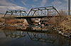 |
19th St. 39°45′36"N 105°0′12"W |
Highland | Extends into Union Station in Downtown Denver National Register of Historic Places listings in Downtown Denver, Colorado This is a list of the National Register of Historic Places listings in Downtown Denver, Colorado.This is intended to be a complete list of the properties and districts on the National Register of Historic Places in downtown Denver, Colorado, United States... |
|
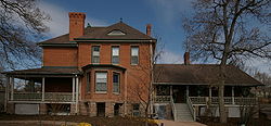
| 2 | All Saints Episcopal Church | 2222 W. 32nd Ave. 39°45′43"N 105°0′49"W |
Highland | |||
| 3 | Avoca Lodge Avoca Lodge Avoca Lodge, known as The Molly Brown Summer House, is a Registered Historic Place in southwest Denver, Colorado near Bear Creek. The home served as a summer retreat for philanthropist, socialite, and activist Margaret Brown and her husband James Joseph Brown.-External links:**... |
 |
2690 S. Wadsworth Boulevard 39°40′5"N 105°4′50"W |
Bear Valley | ||
| 4 | Berkeley Lake Park | Roughly bounded by the northern side of Berkeley Lake, Tennyson St., W. 46th Ave., and Sheridan Boulevard 39°46′56"N 105°2′52"W |
Berkeley Berkeley, Denver Berkeley is a city-center neighborhood in Denver, Colorado, located in the area traditionally called North Denver, on the west side of Interstate 25. The neighborhood is bounded by Federal Boulevard on the east, Interstate 70 on the north, Sheridan Boulevard on the West and 38th avenue on the south... |
|||
| 5 | Berkeley School | 5025-5055 Lowell Boulevard 39°47′19"N 105°2′4"W |
Regis | |||
| 6 | William Norman Bowman House-Yamecila | 325 King St. 39°43′21"N 105°2′1"W |
Barnum Barnum, Denver Barnum is a neighborhood of Denver, Colorado. The neighborhood is located in the area known as West Denver. According to the Piton Foundation, in 2007, the population of the neighborhood was 6,456, and there were 1,924 housing units.-Demographics:... |
|||
| 7 | Bryant-Webster Elementary School | 3635 Quivas St. 39°46′3"N 105°0′28"W |
Highland | |||
| 8 | Building at 1389 Stuart Street | 1389 Stuart St. 39°44′17"N 105°2′33"W |
West Colfax West Colfax, Denver West Colfax is a neighborhood of Denver, Colorado. The neighborhood is located in the West Denver area. According to the Piton Foundation, in 2007, the population of the neighborhood was 11,285, and there were 3,958 housing units.-Boundaries:... |
|||
| 9 | Building at 1390 Stuart Street | 1390 Stuart St. 39°44′17"N 105°2′32"W |
West Colfax West Colfax, Denver West Colfax is a neighborhood of Denver, Colorado. The neighborhood is located in the West Denver area. According to the Piton Foundation, in 2007, the population of the neighborhood was 11,285, and there were 3,958 housing units.-Boundaries:... |
|||
| 10 | Building at 1435 Stuart Street | 1435 Stuart St. 39°44′22"N 105°2′33"W |
West Colfax West Colfax, Denver West Colfax is a neighborhood of Denver, Colorado. The neighborhood is located in the West Denver area. According to the Piton Foundation, in 2007, the population of the neighborhood was 11,285, and there were 3,958 housing units.-Boundaries:... |
|||
| 11 | Building at 1444 Stuart Street | 1444 Stuart St. 39°44′23"N 105°2′32"W |
West Colfax West Colfax, Denver West Colfax is a neighborhood of Denver, Colorado. The neighborhood is located in the West Denver area. According to the Piton Foundation, in 2007, the population of the neighborhood was 11,285, and there were 3,958 housing units.-Boundaries:... |
|||
| 12 | Building at 1471 Stuart Street | 1471 Stuart St. 39°44′23"N 105°2′33"W |
West Colfax West Colfax, Denver West Colfax is a neighborhood of Denver, Colorado. The neighborhood is located in the West Denver area. According to the Piton Foundation, in 2007, the population of the neighborhood was 11,285, and there were 3,958 housing units.-Boundaries:... |
|||
| 13 | Denver Tramway Powerhouse | 1416 Platte St. 39°45′18"N 105°0′32"W |
Highland | |||
| 14 | Dickinson Branch Library | 1545 Hooker St. 39°44′29"N 105°1′41"W |
West Colfax West Colfax, Denver West Colfax is a neighborhood of Denver, Colorado. The neighborhood is located in the West Denver area. According to the Piton Foundation, in 2007, the population of the neighborhood was 11,285, and there were 3,958 housing units.-Boundaries:... |
|||
| 15 | William J. Dunwoody House | 2637 W. 26th Ave. 39°45′18"N 105°1′11"W |
Jefferson Park | |||
| 16 | Elitch Theatre Elitch Theatre The Historic Elitch Theatre is located at the original Elitch Gardens site in northwest Denver, Colorado. Opened in 1890 it was centerpiece of the park that was the First Zoo West of Chicago. The theatre was home to America's first, and oldest summer-stock theater from 1893 until 1987. The first... |
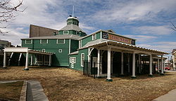 |
W. 38th Ave. and Tennyson St. 39°46′6"N 105°2′46"W |
West Highland | ||
| 17 | Fourth Church of Christ, Scientist Fourth Church of Christ, Scientist (Denver, Colorado) The former Fourth Church of Christ, Scientist, located at 3101 West 31st Avenue, in Denver, Colorado, is a historic structure that on April 21, 2004, was added to the National Register of Historic Places. It is now the Zen Center of Denver.... |
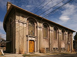 |
3101 W. 31st Ave. 39°45′40"N 105°1′37"W |
West Highland | ||
| 18 | Hanigan-Canino Terrace | 1421-1435 W. 35th Ave. 39°45′57"N 105°0′12"W |
Highland | |||
| 19 | Highland Park | Roughly bounded by Highland Park Pl., Federal Boulevard, and Fairview Pl. 39°45′47"N 105°1′34"W |
West Highland | |||
| 20 | Highland Park Historic District | Bounded by Zuni St., Dunkeld Pl., Clay St., and 32nd Ave. 39°45′39"N 105°1′2"W |
Highland | |||
| 21 | Highlands Masonic Lodge Highlands Masonic Lodge The Highlands Masonic Lodge, also known as Highlands Lodge No. 86 or Pythian Building, in Denver, Colorado, was built in Classical Revival style. It was listed on the National Register of Historic Places in 1995.... |
3220 Federal Boulevard 39°45′45"N 105°1′27"W |
Highland | |||
| 22 | Inspiration Point | Roughly bounded by W. 50th Ave., Sheridan Boulevard, W. 49th Ave., and Fenton St. 39°47′11"N 105°3′22"W |
Regis | |||
| 23 | Loretto Heights Academy | 3001 S. Federal Boulevard 39°39′42"N 105°1′38"W |
Harvey Park South | |||
| 24 | Frederick W. Neef House Frederick W. Neef House The Frederick W. Neef House is a house in Denver, Colorado, United States that was built in 1886. It was listed on the National Register of Historic Places in 1979.-References:... |
2143 Grove St. 39°44′59"N 105°1′35"W |
Sloan Lake Sloan's Lake Sloan's Lake is a body of water, park, and neighborhood in Denver, Colorado, US. The neighborhood is located on the northwest side of Denver... |
|||
| 25 | Niblock-Yacovetta Terrace | 1301-1319 W. 35th Ave. 39°45′57"N 105°0′12"W |
Highland | |||
| 26 | Old Highland Business District | 15th and Boulder Sts. 39°45′29"N 105°0′38"W |
Highland | |||
| 27 | Oriental Theater | 4329-39 W. 44th Ave. 39°46′37"N 105°2′35"W |
Berkeley Berkeley, Denver Berkeley is a city-center neighborhood in Denver, Colorado, located in the area traditionally called North Denver, on the west side of Interstate 25. The neighborhood is bounded by Federal Boulevard on the east, Interstate 70 on the north, Sheridan Boulevard on the West and 38th avenue on the south... |
|||
| 28 | Overland Cotton Mill | 1314 W. Evans Ave. 39°40′36"N 105°0′13"W |
College View and South Platte | |||
| 29 | Potter Highlands Historic District | Roughly bounded by W. 38th, Zuni, and W. 32nd Sts., and Federal Boulevard 39°45′53"N 105°1′9"W |
Highland | |||
| 30 | Rocky Mountain Hotel | 2301 7th St. 39°45′8"N 105°0′51"W |
Jefferson Park | |||
| 31 | Rocky Mountain Lake Park | Roughly bounded by Interstate 70 Interstate 70 Interstate 70 is an Interstate Highway in the United States that runs from Interstate 15 near Cove Fort, Utah, to a Park and Ride near Baltimore, Maryland. It was the first Interstate Highway project in the United States. I-70 approximately traces the path of U.S. Route 40 east of the Rocky... , Federal Boulevard, W. 46th Ave., and Lowell Boulevard 39°46′55"N 105°1′47"W |
Berkeley Berkeley, Denver Berkeley is a city-center neighborhood in Denver, Colorado, located in the area traditionally called North Denver, on the west side of Interstate 25. The neighborhood is bounded by Federal Boulevard on the east, Interstate 70 on the north, Sheridan Boulevard on the West and 38th avenue on the south... |
|||
| 32 | Romeo Block | 2944 Zuni St. 39°45′33"N 105°0′54"W |
Highland | |||
| 33 | Amos H. Root Building | 1501-1529 Platte St. 39°45′24"N 105°0′32"W |
Highland | |||
| 34 | St. Dominic's Church | 3005 W. 29th Ave. 39°45′32"N 105°1′31"W |
West Highland | |||
| 35 | St. Elizabeth's Retreat Chapel | 2825 W. 32nd Ave. 39°45′46"N 105°1′19"W |
Highland | |||
| 36 | St. Joseph's Polish Roman Catholic Church | 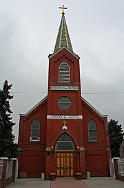 |
517 E. 46th Ave. 39°46′49"N 104°58′54"W |
Globeville Globeville, Denver Globeville is a neighborhood of Denver, Colorado. Globeville is located in the area traditionally called North Denver.-Boundaries:According to a document entitled, Globeville Neighborhood Assessment, prepared by the Denver Department of Planning and Community Development in 2008, "Globeville is... |
||
| 37 | St. Patrick Mission Church | 3325 Pecos St. 39°45′49"N 105°0′23"W |
Highland | |||
| 38 | George Schmidt House | 2345 7th St. 39°45′10"N 105°0′52"W |
Jefferson Park | |||
| 39 | South Platte River Bridges South Platte River Bridges South Platte River Bridges are a pair of historic arch bridges over the South Platte River on the Valley Highway in Denver, Colorado.-External links:*... |
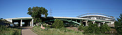 |
Interstate 25 Interstate 25 Interstate 25 is an Interstate Highway in the western United States. It is primarily a north–south highway. I-25 stretches from Interstate 10 at Las Cruces, New Mexico, , to Interstate 90 in Buffalo, Wyoming, .Interstate 25 is the main north–south expressway through... at milepost 210.53 39°44′36"N 105°0′56"W |
Jefferson Park and Sun Valley Sun Valley, Denver Sun Valley is a central Denver neighborhood, bordered by I-25 on the east, Federal Blvd. on the west, 6th Avenue on the south and 20th Ave. on the north. It is located in the area known as West Denver.-Neighborhood characteristics:... |
Extends into Auraria in Northeast Denver National Register of Historic Places listings in Northeast Denver, Colorado This is a list of the National Register of Historic Places listings in Northeast Denver, Colorado.This is intended to be a complete list of the properties and districts on the National Register of Historic Places in northeastern Denver, Colorado, United States... |
|
| 40 | Stonemen's Row Historic District | Southern side of 28th Ave. between Umatilla and Vallejo Sts. 39°45′26"N 105°0′43"W |
Highland | |||
| 41 | Tallmadge and Boyer Block | 2926-2942 Zuni St. 39°45′32"N 105°0′54"W |
Highland | |||
| 42 | Tilden School for Teaching Health | Junction of W. Fairview Pl. and Grove St. 39°45′51"N 105°1′41"W |
West Highland | |||
| 43 | West Forty-sixth Avenue Parkway | W. 46th Ave. Parkway from Stuart St. to Grove St. 39°46′49"N 105°1′33"W |
Berkeley Berkeley, Denver Berkeley is a city-center neighborhood in Denver, Colorado, located in the area traditionally called North Denver, on the west side of Interstate 25. The neighborhood is bounded by Federal Boulevard on the east, Interstate 70 on the north, Sheridan Boulevard on the West and 38th avenue on the south... |
Former listing
| Landmark name | Image | Date removed | Location | City or Town | Summary | |
|---|---|---|---|---|---|---|
| 1 | Wheeler House | 1917 W. 32nd Ave. 39°45′44"N 105°0′34"W |
Highland | Listed March 1, 2000 |
See also
- List of National Historic Landmarks in Colorado
- National Register of Historic Places listings in Denver, Colorado