

Sun Valley, Denver
Encyclopedia
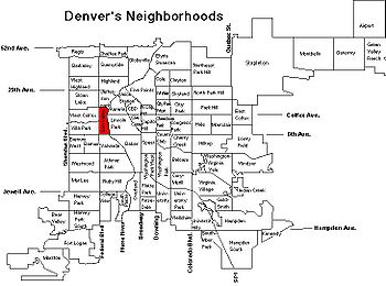
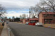
Neighborhood characteristics
Public housing
Public housing is a form of housing tenure in which the property is owned by a government authority, which may be central or local. Social housing is an umbrella term referring to rental housing which may be owned and managed by the state, by non-profit organizations, or by a combination of the...
. Only about 5% of the neighborhood's population live in owner occupied units. Much of the rest of the neighborhood consists of industrial areas, parks, city service buildings and Sports Authority Field at Mile High and its surrounding parking lots. According to the 2000 Census,Sun Valley’s population was 1,496 representing a 2.6% increase over the 1990 population. The census showed that children make up 54% of the population making Sun Valley the only Denver neighborhood where minors outnumber adults.
Lakewood Gulch
Lakewood Gulch
Lakewood Gulch drains a section of Lakewood and west Denver, Colorado into the South Platte River. It is the historic location of the old Interurban Shortline Railway and, in 2008, is a greenbelt that includes Rude Park, Sanchez Park and Lakewood Gulch Park. The gulch passes through Lakewood from...
traverses through the neighborhood, ending at the South Platte River
South Platte River
The South Platte River is one of the two principal tributaries of the Platte River and itself a major river of the American Midwest and the American Southwest/Mountain West, located in the U.S. states of Colorado and Nebraska...
just south of Colfax Avenue
Colfax Avenue
Colfax Avenue is the main street that runs east–west through the Denver-Aurora metropolitan area in Colorado. As U.S. Highway 40, it was one of two principal highways serving Denver before the Interstate Highway System was constructed. In the local street system, it lies 15 blocks north of the zero...
. The creek travels through Rude Park at the west side of the neighborhood. The park contains a recreation center, bike paths and a baseball field. The bike path adjoining the creek between Decatur Street and the South Platte has been closed since 2007 because of a flash flood
Flash flood
A flash flood is a rapid flooding of geomorphic low-lying areas—washes, rivers, dry lakes and basins. It may be caused by heavy rain associated with a storm, hurricane, or tropical storm or meltwater from ice or snow flowing over ice sheets or snowfields...
there that took the life of a toddler . A single stop of the under-construction FasTracks
FasTracks
FasTracks is a twelve-year, $6.5 billion public transportation expansion plan for the Denver-Aurora and Boulder metropolitan areas in Colorado, USA, developed by the Regional Transportation District...
West Corridor Light Rail line will be in Sun Valley at Decatur Street.
Demographics
The 2000 Census found that Sun Valley is overwhelmingly made up of families with children as 70% of all Sun Valley households were families with children less than 18. In large part the high number of children with families is due to the publicly subsidized housing dominant in the neighborhood which gives preference to low-income families . Indeed, the poverty rate in Sun Valley is five times higher than the city of Denver as a whole with 71.5% of its residents living in poverty compared with 14.3% of all Denverites.The Sun Valley neighborhood consists of Census tract 8 (See: http://projects.nytimes.com/census/2010/map). The demographics of the tract were 8% White, 26% Black, 54% Hispanic, 8% Asian, 1% Native American, and 3% Multiracial. The population was 1,448, and the population density was 2,261 people per square mile, with most of the population being concentrated in the public housing centered on 10th Avenue. There were 474 housing units, of which 23 were vacant.