

National Register of Historic Places listings in Venango County, Pennsylvania
Encyclopedia
This is intended to be a complete list of the properties and districts on the National Register of Historic Places
National Register of Historic Places
The National Register of Historic Places is the United States government's official list of districts, sites, buildings, structures, and objects deemed worthy of preservation...
in Venango County
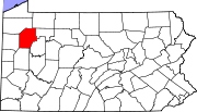
Venango County, Pennsylvania
Venango County is a county located in the U.S. state of Pennsylvania. As of the 2010 census, the population was 54,984. Its county seat is Franklin.-History:Venango County was created on March 12, 1800 from parts of Allegheny and Lycoming Counties...
, Pennsylvania
Pennsylvania
The Commonwealth of Pennsylvania is a U.S. state that is located in the Northeastern and Mid-Atlantic regions of the United States. The state borders Delaware and Maryland to the south, West Virginia to the southwest, Ohio to the west, New York and Ontario, Canada, to the north, and New Jersey to...
, United States
United States
The United States of America is a federal constitutional republic comprising fifty states and a federal district...
. The locations of National Register properties and districts for which the latitude and longitude coordinates are included below, may be seen in a Google map.
There are 19 properties and districts listed on the National Register in the county, including 1 National Historic Landmark
National Historic Landmark
A National Historic Landmark is a building, site, structure, object, or district, that is officially recognized by the United States government for its historical significance...
. Another property was once listed but has been removed.
Current listings
| Landmark name | Image | Date listed | Location | City or Town | Summary | |
|---|---|---|---|---|---|---|
| 1 | Allegheny Baptist Church Allegheny Baptist Church Allegheny Baptist Church is a historic church at PA 27 and Main Street in Pleasantville, Pennsylvania.It was built in 1847 and added to the National Register of Historic Places in 1978.... |
Pennsylvania Route 27 Pennsylvania Route 27 Pennsylvania Route 27 is a long state highway located in northwest Pennsylvania. The western terminus of the route is at Park Avenue near U.S. Route 6 and U.S. Route 19 in Meadville. The eastern terminus is at Pennsylvania Route 69 three miles south of Sugar Grove.-History:From 1927 to 1928, PA... and Main Street 41°35′50"N 79°34′51"W |
Pleasantville Pleasantville, Venango County, Pennsylvania Pleasantville is a borough in Venango County, Pennsylvania in the United States. The population was 850 at the 2000 census, and 892 at the 2010 census. It was an early oil 'boom town', and the population jumped from 291 to 1,598 between 1860 and 1870... |
|||
| 2 | Bridge in Cherrytree Township Jersey Bridge The Jersey Bridge is a one-lane, Pratt through truss bridge that spans Oil Creek in Cherrytree Township, Venango County in the U.S. state of Pennsylvania. It connects the city of Titusville to the Drake Well Museum and Oil Creek State Park. The bridge was listed on the National Register of Historic... |
State Route 1011 over Oil Creek, southeast of Titusville Titusville, Pennsylvania Titusville is a city in Crawford County, Pennsylvania, United States. The population was 6,146 at the 2000 census. In 1859, oil was successfully drilled in Titusville, resulting in the birth of the modern oil industry.-History:... 41°36′55"N 79°39′27"W |
Cherrytree Township | |||
| 3 | Bridge in Clinton Township | State Route 3005 over Scrubgrass Creek, south of Kennerdell 41°14′17"N 79°51′16"W |
Clinton Township Clinton Township, Venango County, Pennsylvania Clinton Township is a township in Venango County, Pennsylvania, United States. The population was 758 at the 2000 census.-Geography:According to the United States Census Bureau, the township has a total area of , of which, of it is land and of it is water.-Demographics:As of the census of 2000,... |
|||
| 4 | Connely-Holeman House | 317 Chestnut Street 41°35′43.25"N 79°35′4.35"W |
Pleasantville Pleasantville, Venango County, Pennsylvania Pleasantville is a borough in Venango County, Pennsylvania in the United States. The population was 850 at the 2000 census, and 892 at the 2010 census. It was an early oil 'boom town', and the population jumped from 291 to 1,598 between 1860 and 1870... |
|||
| 5 | Samuel F. Dale House | 1409 Elk Street 41°23′55"N 79°50′4"W |
Franklin | |||
| 6 | Drake Oil Well | 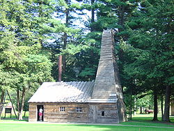 |
3 miles (4.8 km) southeast of Titusville on Pennsylvania Route 36 Pennsylvania Route 36 Pennsylvania Route 36 is a long state highway located in the U.S. state of Pennsylvania. The southern terminus is at Pennsylvania Route 26 near the Hopewell Township community of Yellow Creek... , in Drake Well Memorial Park 41°36′38"N 79°39′28"W |
Cherrytree Township | ||
| 7 | Emlenton Historic District | Roughly bounded by the Allegheny River Allegheny River The Allegheny River is a principal tributary of the Ohio River; it is located in the Eastern United States. The Allegheny River joins with the Monongahela River to form the Ohio River at the "Point" of Point State Park in Downtown Pittsburgh, Pennsylvania... , the borough limits, Kerr Avenue, and Hickory and Center Streets 41°10′47"N 79°42′43"W |
Emlenton Emlenton, Pennsylvania Emlenton is a borough located mostly in Venango County, in the southeastern corner of the county, with a small portion located in Clarion County in Pennsylvania. The population was 784 at the 2000 census... |
|||
| 8 | Franklin Historic District | Roughly bounded by Miller Avenue and Otter, 8th, Buffalo, and 16th Streets 41°23′36"N 79°49′52"W |
Franklin | |||
| 9 | Indian God Rock Petroglyphs Site (36VE26) Indian God Rock Indian God Rock is a large boulder in the northwestern part of the U.S. state of Pennsylvania. Located near the unincorporated community of Brandon, it lies along the Allegheny River in Venango County's Rockland Township. It is significant for the large petroglyph on one of its sides... |
On the eastern bank of the Allegheny River Allegheny River The Allegheny River is a principal tributary of the Ohio River; it is located in the Eastern United States. The Allegheny River joins with the Monongahela River to form the Ohio River at the "Point" of Point State Park in Downtown Pittsburgh, Pennsylvania... above Brandon 41°19′48"N 79°49′27"W |
Rockland Township Rockland Township, Venango County, Pennsylvania Rockland Township is a township in Venango County, Pennsylvania, United States. The population was 1,346 at the 2000 census. The township is quite remote, containing one general store and a volunteer fire department... |
|||
| 10 | National Transit Building | 206 Seneca Street 41°26′6"N 79°42′32"W |
Oil City Oil City, Pennsylvania Oil City is a city in Venango County, Pennsylvania that is known in the initial exploration and development of the petroleum industry. After the first oil wells were drilled nearby in the 1850s, Oil City became central in the petroleum industry while hosting headquarters for the Pennzoil, Quaker... |
|||
| 11 | Oil City Armory | Junction of East 2nd and State Streets 41°25′38"N 79°42′33"W |
Oil City Oil City, Pennsylvania Oil City is a city in Venango County, Pennsylvania that is known in the initial exploration and development of the petroleum industry. After the first oil wells were drilled nearby in the 1850s, Oil City became central in the petroleum industry while hosting headquarters for the Pennzoil, Quaker... |
|||
| 12 | Oil City Downtown Commercial Historic District | Generally along Seneca, Center, Elm, Sycamore, Duncomb, and Main Streets 41°26′8"N 79°42′31"W |
Oil City Oil City, Pennsylvania Oil City is a city in Venango County, Pennsylvania that is known in the initial exploration and development of the petroleum industry. After the first oil wells were drilled nearby in the 1850s, Oil City became central in the petroleum industry while hosting headquarters for the Pennzoil, Quaker... |
|||
| 13 | Oil City North Side Historic District | Roughly bounded by Conrail Consolidated Rail Corporation The Consolidated Rail Corporation, commonly known as Conrail , was the primary Class I railroad in the Northeast U.S. between 1976 and 1999. The federal government created it to take over the potentially profitable lines of bankrupt carriers, including the Penn Central Transportation Company and... railroad, Manning Street, Park Road, Deer Street, and Linden, Hasson, Bishop, Carroll and East Bissell Avenue 41°26′6"N 79°42′45"W |
Oil City Oil City, Pennsylvania Oil City is a city in Venango County, Pennsylvania that is known in the initial exploration and development of the petroleum industry. After the first oil wells were drilled nearby in the 1850s, Oil City became central in the petroleum industry while hosting headquarters for the Pennzoil, Quaker... |
|||
| 14 | Oil City South Side Historic District | Roughly bounded by Allegheny River, Wilson Avenue, Lee's Lane, West Third, and West Fifth Streets, and Reservoir Street 41°25′18"N 79°43′12"W |
Oil City Oil City, Pennsylvania Oil City is a city in Venango County, Pennsylvania that is known in the initial exploration and development of the petroleum industry. After the first oil wells were drilled nearby in the 1850s, Oil City became central in the petroleum industry while hosting headquarters for the Pennzoil, Quaker... |
|||
| 15 | Pithole Stone Arch Pithole Stone Arch Bridge The Pithole Stone Arch Bridge is a masonry, deck arch bridge that spans Pithole Creek between Cornplanter and President Townships, Venango County in the U.S. state of Pennsylvania... |
State Route 1004 over Pithole Creek Pithole Creek Pithole Creek is a tributary of the Allegheny River in Northwest Pennsylvania in the United States. It has a drainage area of . Pithole Creek joins the Allegheny River approximately upstream of Oleopolis.... 41°29′13"N 79°35′43"W |
Cornplanter and President Townships | |||
| 16 | Rockland Furnace | On Shull Run north of the Allegheny River Allegheny River The Allegheny River is a principal tributary of the Ohio River; it is located in the Eastern United States. The Allegheny River joins with the Monongahela River to form the Ohio River at the "Point" of Point State Park in Downtown Pittsburgh, Pennsylvania... , northwest of Emlenton 41°14′3"N 79°44′57"W |
Rockland Township Rockland Township, Venango County, Pennsylvania Rockland Township is a township in Venango County, Pennsylvania, United States. The population was 1,346 at the 2000 census. The township is quite remote, containing one general store and a volunteer fire department... |
|||
| 17 | Site of Pithole City | 10 miles (16.1 km) southeast of Titusville 41°31′16"N 79°35′14"W |
Cornplanter Township | |||
| 18 | U.S. Post Office | 270 Seneca Street 41°26′9"N 79°42′33"W |
Oil City Oil City, Pennsylvania Oil City is a city in Venango County, Pennsylvania that is known in the initial exploration and development of the petroleum industry. After the first oil wells were drilled nearby in the 1850s, Oil City became central in the petroleum industry while hosting headquarters for the Pennzoil, Quaker... |
|||
| 19 | Witherup Bridge | State Route 3007 over Scrubgrass Creek, south of Kennerdell 41°15′18"N 79°50′27"W |
Clinton Township Clinton Township, Venango County, Pennsylvania Clinton Township is a township in Venango County, Pennsylvania, United States. The population was 758 at the 2000 census.-Geography:According to the United States Census Bureau, the township has a total area of , of which, of it is land and of it is water.-Demographics:As of the census of 2000,... |
Former listing
| Landmark name | Image | Date listed | Location | City or Town | Summary | |
|---|---|---|---|---|---|---|
| 1 | Plumer Block | 1205 Liberty Street | Franklin |
See also
- List of National Historic Landmarks in Pennsylvania
- National Register of Historic Places listings in Pennsylvania
- List of Pennsylvania state historical markers in Venango County