

National Register of Historic Places listings in Prescott, Arizona
Encyclopedia
This is a list of the National Register of Historic Places listings in Prescott, Arizona. It is intended to be a complete list of the properties and districts on the National Register of Historic Places
in Prescott
, Arizona
, United States
. The locations of National Register properties and districts for which the latitude and longitude coordinates are included below, may be seen in a Google map.
There are 131 properties and districts listed on the National Register in Yavapai County
, including 1 that is also a National Historic Landmark
. 71 of these properties and districts are located in the city of Prescott, and are listed here, while the remaining 60 properties and districts are located elsewhere in the county, and are listed separately.
National Register of Historic Places
The National Register of Historic Places is the United States government's official list of districts, sites, buildings, structures, and objects deemed worthy of preservation...
in Prescott
Prescott, Arizona
Prescott is a city in Yavapai County, Arizona, USA. It was designated "Arizona's Christmas City" by Arizona Governor Rose Mofford in the late 1980s....
, Arizona
Arizona
Arizona ; is a state located in the southwestern region of the United States. It is also part of the western United States and the mountain west. The capital and largest city is Phoenix...
, United States
United States
The United States of America is a federal constitutional republic comprising fifty states and a federal district...
. The locations of National Register properties and districts for which the latitude and longitude coordinates are included below, may be seen in a Google map.
There are 131 properties and districts listed on the National Register in Yavapai County
Yavapai County, Arizona
-2010:Whereas according to the 2010 U.S. Census Bureau:*89.3% White*0.6% Black*1.7% Native American*0.8% Asian*0.1% Native Hawaiian or Pacific Islander*2.5% Two or more races*5.0% Other races*13.6% Hispanic or Latino -2000:...
, including 1 that is also a National Historic Landmark
National Historic Landmark
A National Historic Landmark is a building, site, structure, object, or district, that is officially recognized by the United States government for its historical significance...
. 71 of these properties and districts are located in the city of Prescott, and are listed here, while the remaining 60 properties and districts are located elsewhere in the county, and are listed separately.
Current listings
| Landmark name | Image | Date listed | Location | Summary | |
|---|---|---|---|---|---|
| 1 | Arizona Pioneers' Home | 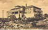 |
300 S. McCormick St. 34°32′15"N 112°28′25"W |
Retirement home complex overlooking Prescott | |
| 2 | Blumberg House | 143 N. Mt. Vernon 34°32′36.33"N 112°27′47.48"W |
|||
| 3 | Brinkmeyer House | 605 W. Gurley | |||
| 4 | Burmister/Timerhoff House | 116 S. Mt. Vernon | |||
| 5 | Clark House | 109 N. Pleasant | |||
| 6 | Courthouse Plaza Historic District | Roughly bounded by Gurley, Montezuma, Cortez, and Goodwin Sts. | |||
| 7 | Curtis Cottage | 125 S. McCormick 34°32′33"N 112°28′22"W |
|||
| 8 | Day House | 212 E. Gurley | |||
| 9 | Detwiler House | 310 N. Alarcon | |||
| 10 | Drake House | 137 N. Mt. Vernon | |||
| 11 | Charles H. Dunning Log Cabin | 811 Boulder Dr. 34°31′40"N 112°28′59"W |
|||
| 12 | East Prescott Historic District | Roughly bounded by Atchison, Topeka, and Santa Fe Atchison, Topeka and Santa Fe Railway The Atchison, Topeka and Santa Fe Railway , often abbreviated as Santa Fe, was one of the larger railroads in the United States. The company was first chartered in February 1859... railroad tracks, N. Mt. Vernon St., Carleton St., and N. Alarcon St. 34°32′35"N 112°27′49"W |
|||
| 13 | Elks Building and Theater Elks Building and Theater The Elks Building and Theater on East Gurley Street in Prescott, Arizona is an Early Commercial style building built in 1904. It has served as a clubhouse. It was listed on the National Register of Historic Places in 1978.... |
117 E. Gurley | |||
| 14 | First Congregational Church and Parsonage | 216-220 E. Gurley | |||
| 15 | Fisher/Goldwater House | 240 S. Cortez | |||
| 16 | Fleury's Addition Historic District | Roughly Western and Gurley from Willow to Grove, and Willow, Garden, and Grove from Western to Gurley 34°33′26"N 112°27′55"W |
|||
| 17 | Fort Whipple-Department of Veterans Affairs Medical Center Historic District | 500 State Route 89 N. 34°32′58"N 112°27′4"W |
Fort Whipple, Arizona Fort Whipple, Arizona Fort Whipple was a U.S. Army post which served as Arizona Territory's capital prior to the founding of Prescott, Arizona. The post was founded by Edward Banker Willis in January 1864 in Chino Valley, Arizona, but was moved in May 1864 to Granite Creek near the present day location of Prescott. ... |
||
| 18 | Fredericks House Fredericks House (Prescott, Arizona) The Fredericks House in Prescott, Arizona was built in 1902. It was listed on the National Register of Historic Places in 1978.... |
202 S. Pleasant | |||
| 19 | Gage/Murphy House | 105 S. Alarcon | |||
| 20 | James I. Gardner Store | 201 N. Cortez 34°32′43"N 112°28′16"W |
|||
| 21 | Henry Goldwater House | 217 E. Union St. 34°32′27"N 112°27′55"W |
|||
| 22 | Groom Creek School | Senator Highway southeast of Prescott in the Prescott National Forest Prescott National Forest The Prescott National Forest is a 1.25 million acre United States National Forest located in north central Arizona in the vicinity of Prescott. The forest is located in the mountains southwest of Flagstaff and north of Phoenix in Yavapai County, with a small portion extending into southwestern... 34°28′15"N 112°26′2"W |
|||
| 23 | Hassayampa Historic District | 1089-1112 Old Hassayampa Ln. and 1106 Country Club Dr. 34°32′8"N 112°29′24"W |
|||
| 24 | Hassayampa Hotel | 122 E. Gurley St 34°32′32"N 112°28′1"W |
Spanish Colonial Revival design by Henry Trost, architect, 1927 http://www.azhistorytraveler.org/templates/content-view.php?nid=2&sid=537 | ||
| 25 | Hawkins House | 122 S. Mt. Vernon | |||
| 26 | Hazeltine House | 202 S. Mt. Vernon | |||
| 27 | Head House | 309 E. Gurley | |||
| 28 | Hill House | 144 S. Park | |||
| 29 | Sam Hill Hardware | 154 S. Montezuma | |||
| 30 | Samuel Hill Hardware Company Warehouse | 232 N. McCormick St. 34°32′44"N 112°28′16"W |
|||
| 31 | Hotel Vendome |  |
230 S. Cortez 34°32′20"N 112°28′6"W |
Operating hotel | |
| 32 | Indian Peak Ruin (AR-03-09-06-116) | Address Restricted | Sinagua Sinagua The Sinagua were a pre-Columbian cultural group occupying an area in central Arizona between the Little Colorado River and the Salt River including the Verde Valley and significant portions of the Mogollon Rim country between approximately 500 AD and 1425 AD.Early Sinagua sites consist of pit houses... ruin |
||
| 33 | Iron Turbine Windmill Iron Turbine Windmill Iron Turbine Windmill is an historic windmill at 415 W. Gurley Street, on the grounds of the Sharlot Hall Museum in Prescott, Arizona. It is technically a windpump, but the American term is windmill.... |
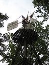 |
415 W. Gurley St. 34°32′30"N 112°28′27"W |
Part of Sharlot Hall Museum Sharlot Hall Museum The Sharlot Hall Museum is an open air museum located in Prescott, Arizona. Opened in 1928 by Sharlot M. Hall as the Old Governor's Mansion Museum, it is dedicated to preserving the history and folklore of Yavapai County, Arizona... |
|
| 34 | Joslin and Whipple Historic District | S. Mt. Vernon, Virginia, Washington, and Arizona Sts. 34°32′19"N 112°27′42"W |
|||
| 35 | Kenwill Apartments | 119-127 E. Goodwin St. 34°32′23"N 112°28′1"W |
|||
| 36 | Lawler-Hetherington Double House | 223 E. Union | |||
| 37 | Lynx Creek Bridge | 5.9 mi (9.5 km) east of Prescott on the Old Black Canyon Highway 34°33′8"N 112°22′21"W |
|||
| 38 | Lynx Creek District | East of Prescott 34°34′28"N 112°20′50"W |
|||
| 39 | Marks House | 203 E. Union | |||
| 40 | Martin/Ling House | 125 N. Pleasant | |||
| 41 | Mile High Park Historic District | Roughly along Oregon Ave. and Josephine St. from Gail Gardner Way and Lindberg Dr. 34°32′49"N 112°29′36"W |
|||
| 42 | Morin House | 134 N. Mt. Vernon | |||
| 43 | former LDS Church | 126 N. Marina St. 34°32′35"N 112°28′1"W |
Converted to commercial use in 1982. | ||
| 44 | Morrison House | 300 S. Marina | |||
| 45 | Mountain States Telephone and Telegraph Exchange Building (Prescott, Arizona) | 116 N. Marina St. 34°32′38"N 112°28′5"W |
|||
| 46 | Mulvenon Building | 230 W. Gurley St. 34°32′32"N 112°28′17"W |
|||
| 47 | North Prescott Townsite Historic District | Between Gurley, Sheldon, Alarcon and Summit Sts. 34°32′37.71"N 112°28′10.74"W |
|||
| 48 | Old Governor's Mansion | 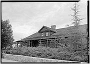 |
415 W. Gurley 34°32′29"N 112°28′23"W |
Now part of the Sharlot Hall Museum Sharlot Hall Museum The Sharlot Hall Museum is an open air museum located in Prescott, Arizona. Opened in 1928 by Sharlot M. Hall as the Old Governor's Mansion Museum, it is dedicated to preserving the history and folklore of Yavapai County, Arizona... |
|
| 49 | Otis House | 113 N. Pleasant | |||
| 50 | Palace Station District | 23 mi (37 km) south of Prescott in the Prescott National Forest Prescott National Forest The Prescott National Forest is a 1.25 million acre United States National Forest located in north central Arizona in the vicinity of Prescott. The forest is located in the mountains southwest of Flagstaff and north of Phoenix in Yavapai County, with a small portion extending into southwestern... 34°22′35"N 112°24′32"W |
Stagecoach station, built 1874 http://www.ghosttowns.com/states/az/palacestation.html | ||
| 51 | Peter House | 211 E. Union | |||
| 52 | Pine Crest Historic District | Roughly bounded by San Carlos St., Coronado Ave., and Yavapai, Apache, and Mohave Drs. 34°32′19"N 112°29′3"W |
|||
| 53 | Prescott Armory Historic District |  |
Roughly bounded by E. Gurley, E. Willis, N. Arizona, E. Sheldon, and N. Rush Sts. 34°33′26"N 112°26′26"W |
||
| 54 | Prescott Public Library | 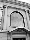 |
125 E. Gurley St. 34°32′28"N 112°28′2"W |
Old Carnegie library Carnegie library A Carnegie library is a library built with money donated by Scottish-American businessman and philanthropist Andrew Carnegie. 2,509 Carnegie libraries were built between 1883 and 1929, including some belonging to public and university library systems... , now an office building |
|
| 55 | Roberts House | 136 N. Pleasant | |||
| 56 | A. W. Robinson Building | 115 N. Grove | |||
| 57 | Sacred Heart Catholic Church and Rectory | 208 N. Marina | Now used as the Prescott Fine Arts Association gallery | ||
| 58 | Santa Fe, Prescott and Phoenix Railroad Depot | Cortez St. 34°32′43"N 112°28′5"W |
|||
| 59 | Sewall House | 220 N. Mt. Vernon | |||
| 60 | Shekels House | 226 S. Cortez | |||
| 61 | Sloan House | 128 N. Mt. Vernon | |||
| 62 | South Prescott Townsite | Roughly bounded by Alarcon, Montezuma, Union, and Leroux Sts. 34°32′11"N 112°28′4"W |
|||
| 63 | Toltec Lodge | 228 High St. 34°32′23"N 112°28′47"W |
|||
| 64 | US Post Office and Courthouse-Prescott Main | 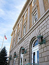 |
101 W. Goodwin Ave. 34°32′24"N 112°28′9"W |
||
| 65 | Walker Charcoal Kiln Walker Charcoal Kiln The Walker Charcoal Kiln is a structure in the Prescott National Forest near the ghost town of Walker, Arizona. It is listed on the National Register of Historic Places. A sign posted near the kiln reads, "This kiln was constructed around 1880 by Jake and Joe Carmichael to convert oak wood into... |
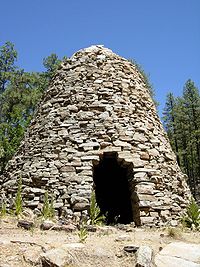 |
Southeast of Prescott in the Prescott National Forest Prescott National Forest The Prescott National Forest is a 1.25 million acre United States National Forest located in north central Arizona in the vicinity of Prescott. The forest is located in the mountains southwest of Flagstaff and north of Phoenix in Yavapai County, with a small portion extending into southwestern... 34°27′30"N 112°22′31"W |
||
| 66 | Walnut Creek Ranger Station Walnut Creek Ranger Station Walnut Creek Ranger Station, also known as Walnut Creek Work Center, in Prescott National Forest near Prescott, Arizona was built in 1931 by the Civilian Conservation Corps. It was listed on the National Register of Historic Places in 1993 for its architecture, which is Bungalow/Craftsman style. ... |
Northwest of Prescott in the Prescott National Forest Prescott National Forest The Prescott National Forest is a 1.25 million acre United States National Forest located in north central Arizona in the vicinity of Prescott. The forest is located in the mountains southwest of Flagstaff and north of Phoenix in Yavapai County, with a small portion extending into southwestern... 34°55′28"N 112°50′24"W |
|||
| 67 | Wells House | 303 S. Cortez | |||
| 68 | West Prescott Historic District | Roughly bounded by Gurley Dr., Park Ave., Country Club Dr., Vista Dr., and Coronado Ave.; also 617-621 Glenwood Ave. and 330, 334, 340, 344, and 348 Moreland Circle 34°32′15"N 112°28′41"W |
Second set of addresses represents a boundary increase | ||
| 69 | Whipple Heights Historic District | E. Gurley, N. Virginia, Washington, and E. Moeller Sts. 34°32′36"N 112°27′40"W |
|||
| 70 | Wilder House | 346 S. Montezuma | |||
| 71 | Yavapai County Courthouse | 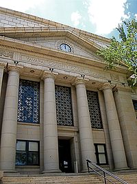 |
Courthouse Sq. 34°32′27"N 112°28′6"W |
1918 Greek Revival style building http://www.azhistorytraveler.org/templates/content-view.php?nid=2&sid=554 |
See also
- List of National Historic Landmarks in Arizona
- National Register of Historic Places listings in Arizona