

National Register of Historic Places listings in Indiana County, Pennsylvania
Encyclopedia
This is intended to be a complete list of the properties and districts on the National Register of Historic Places
National Register of Historic Places
The National Register of Historic Places is the United States government's official list of districts, sites, buildings, structures, and objects deemed worthy of preservation...
in Indiana County
Indiana County, Pennsylvania
-Government and politics:As of November 2008, there are 58,077 registered voters in Indiana County .* Democratic: 26,653 * Republican: 24,159 * Other Parties: 7,265 -County commissioners:*Rodney Ruddock, Chairman, Republican...
, Pennsylvania
Pennsylvania
The Commonwealth of Pennsylvania is a U.S. state that is located in the Northeastern and Mid-Atlantic regions of the United States. The state borders Delaware and Maryland to the south, West Virginia to the southwest, Ohio to the west, New York and Ontario, Canada, to the north, and New Jersey to...
, United States
United States
The United States of America is a federal constitutional republic comprising fifty states and a federal district...
. The locations of National Register properties and districts for which the latitude and longitude coordinates are included below, may be seen in a Google map.
There are 24 properties and districts listed on the National Register in the county.
Current listings
| Landmark name | Image | Date listed | Location | City or Town | Summary | |
|---|---|---|---|---|---|---|
| 1 | Blairsville Armory | 119 North Walnut Street 40°25′55"N 79°15′54"W |
Blairsville Blairsville, Pennsylvania -External links:* * *... |
|||
| 2 | Breezedale |  |
Indiana University of Pennsylvania Indiana University of Pennsylvania Indiana University of Pennsylvania is a public university in Indiana County, Pennsylvania, USA. The university is northeast of Pittsburgh. It is the largest university in the Pennsylvania State System of Higher Education and is the commonwealth's fifth largest university... campus 40°37′11"N 79°9′23"W |
Indiana Indiana, Pennsylvania Indiana is a borough in and the county seat of Indiana County, Pennsylvania, United States. The population was 14,895 at the 2000 census.The borough and the region as a whole promotes itself as the "Christmas Tree Capital of the World" because the national Christmas Tree Grower's Association was... |
||
| 3 | Bridge in West Wheatfield Township | Legislative Route 32008 over Richards Run, northeast of Robinson 40°24′11"N 79°7′45"W |
West Wheatfield Township | |||
| 4 | Buffalo, Rochester & Pittsburgh Railway Indiana Passenger Station | 1125 Philadelphia Street 40°37′24"N 79°9′42"W |
Indiana Indiana, Pennsylvania Indiana is a borough in and the county seat of Indiana County, Pennsylvania, United States. The population was 14,895 at the 2000 census.The borough and the region as a whole promotes itself as the "Christmas Tree Capital of the World" because the national Christmas Tree Grower's Association was... |
|||
| 5 | 6th Street and Wayne Avenue 40°37′12"N 79°9′5"W |
Indiana Indiana, Pennsylvania Indiana is a borough in and the county seat of Indiana County, Pennsylvania, United States. The population was 14,895 at the 2000 census.The borough and the region as a whole promotes itself as the "Christmas Tree Capital of the World" because the national Christmas Tree Grower's Association was... |
||||
| 6 | 247 1st Avenue 40°49′1.2"N 78°49′35"W |
Glen Campbell Glen Campbell, Pennsylvania Glen Campbell is a borough in Indiana County, Pennsylvania, United States. The population was 306 at the 2000 census. The borough was named in 1889 for Cornelius Campbell, the first superintendent of the Glenwood Coal Company , which mined in that area.The modern singer Glen Campbell visited Glen... |
||||
| 7 | Commodore Historic District | Roughly bounded by Pennsylvania Route 286 Pennsylvania Route 286 Pennsylvania Route 286 is an long, east–west state highway located in Allegheny, Westmoreland, Indiana, and Clearfield counties in Pennsylvania. The western terminus is at US 22 in Monroeville. The eastern terminus is at US 219 near Burnside.... , Vanderbilt Avenue, Musser Street, and Fisher Avenue in Commodore 40°42′49"N 78°56′39"W |
Green Township Green Township, Indiana County, Pennsylvania Green Township is a township in Indiana County, Pennsylvania, United States. The population was 3,995 at the 2000 census.-Geography:According to the United States Census Bureau, the township has a total area of , all of it land.-Demographics:... |
|||
| 8 | George Diehl Homestead | East of U.S. Route 422 U.S. Route 422 U.S. Route 422 is a long spur route of US 22 split into two segments in the U.S. states of Ohio and Pennsylvania. The western spur begins in downtown Cleveland, Ohio, and ends at Ebensburg, Pennsylvania... on Diehl Road, east of Indiana 40°36′29"N 78°58′44"W |
Cherryhill Township Cherryhill Township, Pennsylvania Cherryhill Township is a township in Indiana County, Pennsylvania, United States. The population was 2,842 at the 2000 census.-Geography:According to the United States Census Bureau, the township has a total area of , of which, of it is land and of it is water.-Demographics:As of the census of... |
|||
| 9 | Downtown Indiana Historic District | Roughly bounded by Water, 7th, and 6th Streets and Wayne Avenue 40°37′20"N 79°9′6"W |
Indiana Indiana, Pennsylvania Indiana is a borough in and the county seat of Indiana County, Pennsylvania, United States. The population was 14,895 at the 2000 census.The borough and the region as a whole promotes itself as the "Christmas Tree Capital of the World" because the national Christmas Tree Grower's Association was... |
|||
| 10 | Eliza Furnace | Lower Main Street, west of Vintondale 40°29′3"N 78°55′20"W |
Buffington Township | Extends into Cambria County National Register of Historic Places listings in Cambria County, Pennsylvania This is a list of the National Register of Historic Places listings in Cambria County, Pennsylvania.This is intended to be a complete list of the properties and districts on National Register of Historic Places in the Cambria County, Pennsylvania... |
||
| 11 | Graff's Market | 27 North 6th Street 40°37′25"N 79°9′2"W |
Indiana Indiana, Pennsylvania Indiana is a borough in and the county seat of Indiana County, Pennsylvania, United States. The population was 14,895 at the 2000 census.The borough and the region as a whole promotes itself as the "Christmas Tree Capital of the World" because the national Christmas Tree Grower's Association was... |
|||
| 12 | Harmon's Covered Bridge | Northeast of Willet 40°44′2.4"N 79°10′31.37"W |
Washington Township Washington Township, Indiana County, Pennsylvania Washington Township is a township in Indiana County, Pennsylvania, United States. The population was 1,805 at the 2000 census.-Geography:According to the United States Census Bureau, the township has a total area of 38.3 square miles , all of it land.-Demographics:As of the census of 2000,... |
|||
| 13 | Indiana Armory | 621 Wayne Avenue 40°37′11"N 79°9′5"W |
Indiana Indiana, Pennsylvania Indiana is a borough in and the county seat of Indiana County, Pennsylvania, United States. The population was 14,895 at the 2000 census.The borough and the region as a whole promotes itself as the "Christmas Tree Capital of the World" because the national Christmas Tree Grower's Association was... |
|||
| 14 | Indiana Borough 1912 Municipal Building | 39 7th Street 40°37′14"N 79°9′11"W |
Indiana Indiana, Pennsylvania Indiana is a borough in and the county seat of Indiana County, Pennsylvania, United States. The population was 14,895 at the 2000 census.The borough and the region as a whole promotes itself as the "Christmas Tree Capital of the World" because the national Christmas Tree Grower's Association was... |
|||
| 15 | Kintersburg Covered Bridge Kintersburg Covered Bridge The Kintersburg Covered Bridge is a covered bridge spanning Crooked Creek in Indiana County, Pennsylvania, United States. Built in 1877, it is one of four covered bridges in the county, and is the only one with a Howe truss design. The Howe design is rather rare in covered bridges. The... |
South of Kintersburg 40°42′48"N 79°4′53"W |
Rayne Township | |||
| 16 | John B. McCormick House | West of Georgeville off Pennsylvania Route 210 Pennsylvania Route 210 Pennsylvania Route 210 is an long state highway located in Armstrong and Indiana counties in Western Pennsylvania. The southern terminus is at PA 56/PA 156 in South Bend Township... 40°50′19"N 79°7′2"W |
South Mahoning Township | |||
| 17 | James Mitchell House | 57 South 6th Street 40°37′18"N 79°9′2"W |
Indiana Indiana, Pennsylvania Indiana is a borough in and the county seat of Indiana County, Pennsylvania, United States. The population was 14,895 at the 2000 census.The borough and the region as a whole promotes itself as the "Christmas Tree Capital of the World" because the national Christmas Tree Grower's Association was... |
|||
| 18 | Old Indiana County Courthouse | 601 Philadelphia Street 40°37′23"N 79°9′7"W |
Indiana Indiana, Pennsylvania Indiana is a borough in and the county seat of Indiana County, Pennsylvania, United States. The population was 14,895 at the 2000 census.The borough and the region as a whole promotes itself as the "Christmas Tree Capital of the World" because the national Christmas Tree Grower's Association was... |
|||
| 19 | Old Indiana County Jail and Sheriff's Office | 6th Street and Nixon Avenue 40°37′23"N 79°9′8"W |
Indiana Indiana, Pennsylvania Indiana is a borough in and the county seat of Indiana County, Pennsylvania, United States. The population was 14,895 at the 2000 census.The borough and the region as a whole promotes itself as the "Christmas Tree Capital of the World" because the national Christmas Tree Grower's Association was... |
|||
| 20 | St. Peter's Episcopal Church and Rectory St. Peter's Episcopal Church and Rectory St. Peter's Episcopal Church and Rectory is a historic church at 36-38 W. Campbell Street in Blairsville, Pennsylvania.It was built in 1830 and added to National Register in 1988.-References:... |
36–38 West Campbell Street 40°25′55"N 79°15′51"W |
Blairsville Blairsville, Pennsylvania -External links:* * *... |
|||
| 21 | Saltsburg Historic District | 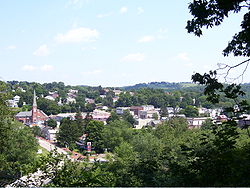 |
Roughly west of Plum and Walnut Alleys to the Kiskiminetas River Kiskiminetas River The Kiskiminetas River is a tributary of the Allegheny River, approximately long, in Western Pennsylvania in the United States... 40°29′2"N 79°27′4"W |
Saltsburg Saltsburg, Pennsylvania Saltsburg is a borough in Indiana County, Pennsylvania, United States. The population was 955 at the 2000 census. The town was based on the construction of salt wells and the canals and railroad tracks that passed through it.-Geography:... |
||
| 22 | John Sutton Hall John Sutton Hall John Sutton Hall is the main building of Indiana University of Pennsylvania. Constructed between 1873 and 1875, the building was the first constructed for the Indiana Normal School. In 1903, the building was named after John Sutton, the first president of the school's Board of Trustees... |
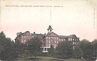 |
Indiana University of Pennsylvania Indiana University of Pennsylvania Indiana University of Pennsylvania is a public university in Indiana County, Pennsylvania, USA. The university is northeast of Pittsburgh. It is the largest university in the Pennsylvania State System of Higher Education and is the commonwealth's fifth largest university... campus 40°37′3"N 79°9′32"W |
Indiana Indiana, Pennsylvania Indiana is a borough in and the county seat of Indiana County, Pennsylvania, United States. The population was 14,895 at the 2000 census.The borough and the region as a whole promotes itself as the "Christmas Tree Capital of the World" because the national Christmas Tree Grower's Association was... |
||
| 23 | Thomas Covered Bridge | North of Fulton Run, southwest of Creekside 40°39′50"N 79°14′13"W |
Washington Township Washington Township, Indiana County, Pennsylvania Washington Township is a township in Indiana County, Pennsylvania, United States. The population was 1,805 at the 2000 census.-Geography:According to the United States Census Bureau, the township has a total area of 38.3 square miles , all of it land.-Demographics:As of the census of 2000,... |
|||
| 24 | Trusal Covered Bridge | West of Willet 40°43′49"N 79°11′5"W |
Washington Township Washington Township, Indiana County, Pennsylvania Washington Township is a township in Indiana County, Pennsylvania, United States. The population was 1,805 at the 2000 census.-Geography:According to the United States Census Bureau, the township has a total area of 38.3 square miles , all of it land.-Demographics:As of the census of 2000,... |
See also
- List of National Historic Landmarks in Pennsylvania
- National Register of Historic Places listings in Pennsylvania
- List of Pennsylvania state historical markers in Indiana County