
Nasarawa State
Encyclopedia
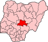
Nasarawa State is a state in central
Nigeria
. Its capital is Lafia
.
government from the (today neighboring) Plateau State
.
, in the west by the Abuja Federal Capital Territory, in the south by Kogi
and Benue State
s and in the east by Taraba
and Plateau State
s.
A network of roads exist within the state, linking all the rural areas and major towns. The Nigerian Railway Corporation
(NRC) operates train services from Kuru
, Gombe
and Maiduguri
.
 Nasarawa State has agriculture
as the mainstay of its economy
with the production of varieties of cash crop
s throughout the year. It is also contains minerals such as salt
and bauxite
.
in Nasarawa
local Government Area of the state, College of Education
in Akwanga
, Nasarawa State University
in Keffi
,a newly established Federal University of Lafia
in Lafia town, and other vocational training schools.
in Wamba
local Government area of the state. Farin Ruwa falls is reputed to be one of the highest falls in Africa..
Middle Belt
The Middle Belt is a human geographical term designating the region of central Nigeria populated largely by minority ethnic groups and stretching across the country longitudinally. The Middle Belt is indeterminate in that it lacks designated "borders" and is charactized by a heterogeneity and...
Nigeria
Nigeria
Nigeria , officially the Federal Republic of Nigeria, is a federal constitutional republic comprising 36 states and its Federal Capital Territory, Abuja. The country is located in West Africa and shares land borders with the Republic of Benin in the west, Chad and Cameroon in the east, and Niger in...
. Its capital is Lafia
Lafia
Lafia is a town in central Nigeria. It is the capital city of Nasarawa State and has a population of 330,712 inhabitants according to the 2006 census results .It is the largest town in Nasarawa state.- History :...
.
History
Nasarawa was created on 1 October 1996 by the AbachaSani Abacha
General Sani Abacha was a Nigerian military leader and politician. A Kanuri from Borno by tribe, he was born and brought up in Kano, Nigeria. He was the de facto President of Nigeria from 1993 to 1998....
government from the (today neighboring) Plateau State
Plateau State
Plateau State is the twelfth largest state of Nigeria, and is roughly located in the center of the country. It is geographically unique in Nigeria because its boundaries totally surround the Jos Plateau, having the Jos Plateau totally in its central and northern part...
.
Geography
Nasarawa State is bounded in the north by Kaduna StateKaduna State
-History:The state is the successor to the old Northern Region of Nigeria, which had its capital at Kaduna. In 1967 this was split up into six states, one of which was the North-Central State, whose name was changed to Kaduna State in 1976. This was further divided in 1987, losing the area now part...
, in the west by the Abuja Federal Capital Territory, in the south by Kogi
Kogi State
Kogi state is found in the central region of Nigeria. It is popularly called the Confluence State because the confluence of River Niger and River Benue is at its capital, Lokoja, which is the first administrative capital of modern-day Nigeria....
and Benue State
Benue State
Benue is a state in the Middle-Belt region of Nigeria with a population of about 2.8 million in 1991. Tiv, Idoma, and Igede are spoken predominantly. There are other ethnic groups as well. These include Etulo and Abakwa...
s and in the east by Taraba
Taraba State
Taraba State is a state of Nigeria, named after the Taraba River which traverses the southern part of the state. Taraba's capital is Jalingo.-History:...
and Plateau State
Plateau State
Plateau State is the twelfth largest state of Nigeria, and is roughly located in the center of the country. It is geographically unique in Nigeria because its boundaries totally surround the Jos Plateau, having the Jos Plateau totally in its central and northern part...
s.
A network of roads exist within the state, linking all the rural areas and major towns. The Nigerian Railway Corporation
Nigerian Railway Corporation
Nigerian Railway Corporation is the government body operating railways in Nigeria.- Infrastructure and operations :Nigerian Railway Corporation operates a network of of single track lines, all have gauge....
(NRC) operates train services from Kuru
Kuru, Nigeria
Kuru is located on the Jos Plateau in north-central Nigeria commonly referred as the middle belt region of Nigeria. Located about 20 km to Jos on the Jos-Abuja highway in Plateau State...
, Gombe
Gombe, Nigeria
Gombe is a city in northeastern Nigeria . It is the capital city of Gombe State and has an estimated population of 261,536. The city is the headquarters of the Gombe Emirate, a traditional state that covers most of Gombe State...
and Maiduguri
Maiduguri
Maiduguri, also fondly called Yerwa by its locals, is the capital and the largest city of Borno State in north-eastern Nigeria. The city sits along the seasonal Ngadda River which disappears into the Firki swamps in the areas around Lake Chad...
.
Local Government Areas
The thirteen Local Government Areas of Nasarawa State are:- AkwangaAkwangaAkwanga is a Local Government Area in Nasarawa State, Nigeria. Its headquarters are in the town of Akwanga.It has an area of 996 km² and a population of 113,430 at the 2006 census.The postal code of the area is 960....
- AweAwe, NigeriaAwe is a Local Government Area in Nasarawa State, Nigeria. Its headquarters are in the town of Awe.It has an area of 2,557 km² and a population of 112,574 at the 2006 census.The postal code of the area is 951....
- DomaDoma, NigeriaDoma is a Local Government Area in Nasarawa State, Nigeria. Its headquarters are in the town of Doma.It has an area of 2,714 km² and a population of 139,607 at the 2006 census.The postal code of the area is 950....
- KaruKaru, Nasarawa StateKaru is a Local Government Area in Nasarawa State, central Nigeria.It is close in proximity to the Federal Capital Territory of Nigeria. It has an area of 2,640 km².Karu local government has its headquarters in New Karu town....
- KeanaKeanaKeana is a Local Government Area in Nasarawa State, Nigeria. Its headquarters are in the town of Keana.It has an area of 1,048 km² and a population of 79,253 at the 2006 census.The postal code of the area is 951....
- KeffiKeffiKeffi is a Local Government Area in Nasarawa State, Nigeria. Its headquarters are in the town of Keffi.It has an area of 138 km² and a population of 92,664 at the 2006 census.The postal code of the area is 961.- Education :...
- KokonaKokonaKokona is a Local Government Area in Nasarawa State, Nigeria. Its headquarters are in the town of Kokona.It has an area of 1,844 km² and a population of 109,749 at the 2006 census.The postal code of the area is 961....
- LafiaLafiaLafia is a town in central Nigeria. It is the capital city of Nasarawa State and has a population of 330,712 inhabitants according to the 2006 census results .It is the largest town in Nasarawa state.- History :...
- NasarawaNasarawa, Nasarawa StateNasarawa is a Local Government Area in Nasarawa State, Nigeria. Its headquarters are in the town of Nasarawa.It has an area of 5,704 km² and a population of 189,835 at the 2006 census.The postal code of the area is 962.-Education:...
- Nasarawa EgonNasarawa EgonNasarawa Egon is a Local Government Area in Nasarawa State, Nigeria. Its headquarters are in the town of Nasarawa Egon.It has an area of 1,208 km² and a population of 149,129 at the 2006 census.The postal code of the area is 960....
- ObiObi, Nasarawa StateObi is a Local Government Area in Nasarawa State, Nigeria. Its headquarters are in the town of Obi.It has an area of 967 km² and a population of 148,874 at the 2006 census.The postal code of the area is 951....
- TotoToto, NigeriaToto is a Local Government Area in Nasarawa State, Nigeria. Its headquarters are in the town of Toto.It has an area of 2,903 km² and a population of 119,077 at the 2006 census.The postal code of the area is 962....
- WambaWamba, NigeriaWamba is a Local Government Area in Nasarawa State, Nigeria. Its headquarters are in the town of Wamba.It has an area of 1,156 km² and a population of 72,894 at the 2006 census.- Attractions :...
Economy
Agriculture
Agriculture is the cultivation of animals, plants, fungi and other life forms for food, fiber, and other products used to sustain life. Agriculture was the key implement in the rise of sedentary human civilization, whereby farming of domesticated species created food surpluses that nurtured the...
as the mainstay of its economy
Economy
An economy consists of the economic system of a country or other area; the labor, capital and land resources; and the manufacturing, trade, distribution, and consumption of goods and services of that area...
with the production of varieties of cash crop
Cash crop
In agriculture, a cash crop is a crop which is grown for profit.The term is used to differentiate from subsistence crops, which are those fed to the producer's own livestock or grown as food for the producer's family...
s throughout the year. It is also contains minerals such as salt
Salt
In chemistry, salts are ionic compounds that result from the neutralization reaction of an acid and a base. They are composed of cations and anions so that the product is electrically neutral...
and bauxite
Bauxite
Bauxite is an aluminium ore and is the main source of aluminium. This form of rock consists mostly of the minerals gibbsite Al3, boehmite γ-AlO, and diaspore α-AlO, in a mixture with the two iron oxides goethite and hematite, the clay mineral kaolinite, and small amounts of anatase TiO2...
.
Education
The state has a Federal PolytechnicInstitute of technology
Institute of technology is a designation employed in a wide range of learning institutions awarding different types of degrees and operating often at variable levels of the educational system...
in Nasarawa
Nasarawa, Nasarawa State
Nasarawa is a Local Government Area in Nasarawa State, Nigeria. Its headquarters are in the town of Nasarawa.It has an area of 5,704 km² and a population of 189,835 at the 2006 census.The postal code of the area is 962.-Education:...
local Government Area of the state, College of Education
Nasarawa State College of Education, Akwanga
The College of Education, Akwanga,is a tertiary institution located in Akwanga town in Akwanga Local Government Area in Nasarawa State,in central Nigeria.- History :...
in Akwanga
Akwanga
Akwanga is a Local Government Area in Nasarawa State, Nigeria. Its headquarters are in the town of Akwanga.It has an area of 996 km² and a population of 113,430 at the 2006 census.The postal code of the area is 960....
, Nasarawa State University
Nasarawa State University
- External Links :**...
in Keffi
Keffi
Keffi is a Local Government Area in Nasarawa State, Nigeria. Its headquarters are in the town of Keffi.It has an area of 138 km² and a population of 92,664 at the 2006 census.The postal code of the area is 961.- Education :...
,a newly established Federal University of Lafia
Federal University of Technology, Lafia
The Federal University of Technology,Lafia is a new technology oriented university established in Lafia, the capital of Nasarawa State in 2010 by the Goodluck Jonathan administration as one of the nine new federal universities established in the six geo-political zones of Nigeria.The university is...
in Lafia town, and other vocational training schools.
Tourism
Nassarawa state is home to the Farin Ruwa FallsFarin Ruwa Falls
Farin Ruwa Falls is a waterfall found in the central region of Nigeria. It is among the highest waterfalls in Nigeria.It is a fall to be reckoned with in Africa when the total height covered by the waterfall is considered....
in Wamba
Wamba, Nigeria
Wamba is a Local Government Area in Nasarawa State, Nigeria. Its headquarters are in the town of Wamba.It has an area of 1,156 km² and a population of 72,894 at the 2006 census.- Attractions :...
local Government area of the state. Farin Ruwa falls is reputed to be one of the highest falls in Africa..