
Nabesna Glacier
Encyclopedia
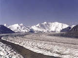
Nabesna Glacier is a glacier
in the U.S. state
of Alaska
. Fed by deep snowfall in the Wrangell Mountains
, the 75 mile (120 km) long Nabesna is the longest valley glacier in North America
and the world's longest interior valley glacier.
The glacier flows from an extensive icefield which covers the northern flanks of 14163 feet (4,317 m) Mount Wrangell
, a large shield volcano
. It heads initially east past other volcanic peaks including Mount Blackburn
and Atna Peaks
and then turns north to its terminus
near 3,000 ft (900 m) elevation, about 15 mi (24 km) south of the old mining settlement of Nabesna at the end of the Nabesna Road. The vast expanse and length of the Nabesna is fed by approximately 40 tributary glaciers. Melting ice at its terminus forms the Nabesna River, which flows northward through Tetlin National Wildlife Refuge
and into the Tanana River
.
The glacier was named for the Nabesna River in 1902 by F. C. Schrader of the U.S. Geological Survey. It provides the normal route of access into the heart of the eastern Wrangell Mountains, for ski mountaineers, climbers, and scientists. Ski-equipped bush plane
s can typically land between 6,000 and 7,000 ft (1,800-2,100 m) on the central portion of the glacier when the ice and crevasses are covered by winter snow.
Glacier
A glacier is a large persistent body of ice that forms where the accumulation of snow exceeds its ablation over many years, often centuries. At least 0.1 km² in area and 50 m thick, but often much larger, a glacier slowly deforms and flows due to stresses induced by its weight...
in the U.S. state
U.S. state
A U.S. state is any one of the 50 federated states of the United States of America that share sovereignty with the federal government. Because of this shared sovereignty, an American is a citizen both of the federal entity and of his or her state of domicile. Four states use the official title of...
of Alaska
Alaska
Alaska is the largest state in the United States by area. It is situated in the northwest extremity of the North American continent, with Canada to the east, the Arctic Ocean to the north, and the Pacific Ocean to the west and south, with Russia further west across the Bering Strait...
. Fed by deep snowfall in the Wrangell Mountains
Wrangell Mountains
The Wrangell Mountains are a high mountain range of eastern Alaska in the United States. Much of the range is included in Wrangell-Saint Elias National Park and Preserve. The Wrangell Mountains are almost entirely volcanic in origin, and they include the second and third highest volcanoes in the...
, the 75 mile (120 km) long Nabesna is the longest valley glacier in North America
North America
North America is a continent wholly within the Northern Hemisphere and almost wholly within the Western Hemisphere. It is also considered a northern subcontinent of the Americas...
and the world's longest interior valley glacier.
The glacier flows from an extensive icefield which covers the northern flanks of 14163 feet (4,317 m) Mount Wrangell
Mount Wrangell
Mount Wrangell is a massive shield volcano located in Wrangell-St. Elias National Park and Preserve in southeastern Alaska, United States. The shield rises over above the Copper River to its southwest. Its volume is over , making it more than twice as massive as Mount Shasta in California, the...
, a large shield volcano
Shield volcano
A shield volcano is a type of volcano usually built almost entirely of fluid lava flows. They are named for their large size and low profile, resembling a warrior's shield. This is caused by the highly fluid lava they erupt, which travels farther than lava erupted from more explosive volcanoes...
. It heads initially east past other volcanic peaks including Mount Blackburn
Mount Blackburn
Mount Blackburn is the highest peak in the Wrangell Mountains of Alaska in the United States. It is the fifth highest peak in the United States and the twelfth highest peak in North America. The mountain is an old, eroded shield volcano, the second highest volcano in the United States behind Mount...
and Atna Peaks
Atna Peaks
Atna Peaks is an eroded stratovolcano or shield volcano in the Wrangell Mountains of eastern Alaska. It is located in Wrangell-Saint Elias National Park about 6 mi east of Mount Blackburn, the second highest volcano in the United States, and just south of the massive Nabesna Glacier...
and then turns north to its terminus
Glacier terminus
A glacier terminus, or snout, is the end of a glacier at any given point in time. Although glaciers seem motionless to the observer, in reality glaciers are in endless motion and the glacier terminus is always either advancing or retreating...
near 3,000 ft (900 m) elevation, about 15 mi (24 km) south of the old mining settlement of Nabesna at the end of the Nabesna Road. The vast expanse and length of the Nabesna is fed by approximately 40 tributary glaciers. Melting ice at its terminus forms the Nabesna River, which flows northward through Tetlin National Wildlife Refuge
Tetlin National Wildlife Refuge
Tetlin National Wildlife Refuge is a dynamic landscape made up of forests, wetlands, tundra, lakes, mountains and glacial rivers bounded by the snowy peaks of the Alaska Range. This upper Tanana River valley has been called the "Tetlin Passage," because it serves as a major migratory route for...
and into the Tanana River
Tanana River
The Tanana River is a tributary of the Yukon River in the U.S. state of Alaska. According to linguist and anthropologist William Bright, the name is from the Koyukon tene no, tenene, literally "trail river"....
.
The glacier was named for the Nabesna River in 1902 by F. C. Schrader of the U.S. Geological Survey. It provides the normal route of access into the heart of the eastern Wrangell Mountains, for ski mountaineers, climbers, and scientists. Ski-equipped bush plane
Bush plane
A bush airplane is a general aviation aircraft serving remote, undeveloped areas of a country, usually the African bush, Alaskan and Canadian tundra or the Australian Outback...
s can typically land between 6,000 and 7,000 ft (1,800-2,100 m) on the central portion of the glacier when the ice and crevasses are covered by winter snow.