
NATO Dispersed Operating Bases
Encyclopedia
NATO Dispersed Operating Bases (DOBs) were developed to improve air power survival when NATO began planning for tactical air bases and aircraft in western Europe during the early Cold War
years of the 1950s.
was less concerned than its allies about base defence and dispersal due to the total air superiority and unlimited resources of aircraft, aircrews and ground personnel to replace combat losses.
After D-Day
as allied tactical air forces moved rapidly across France, investment in base and aircraft survival was impractical. It was quicker and cheaper to use captured Luftwaffe
facilities. By 1948 these small airfields had been abandoned and most structures were removed or were in a state of disrepair.
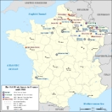
With the advent of the Cold War, NATO faced several problems when attempting to solve the air power survival equation. Planning for first strike survival in both conventional and nuclear wars had to be considered. The main air bases were built on small parcels of land with very limited dispersal space. It was decided to build DOBs at least 30 miles (50 kilometers) from the main air bases to be used in the event of an emergency. The goal was to have no more than one fighter squadron on each main or dispersed base in the event of war.
Beginning in 1953 USAFE DOBs were constructed in France and were completed in about two years. Each was built to a standard NATO design of a 7,900' runway and the ability to space parked aircraft as far apart as possible by the construction of a circular marguerite system of hardstands that could be revetted later with earth for added protection.
Typically the margueriete consisted of fifteen to eighteen hardstands around a large central hangar. Each hardstand held one or two aircraft, and allowed the planes to be spaced approximately 150 feet (50 meters) apart. Each squadron was assigned to a separate hangar/hardstand complex.
Four DOBs were built for USAFE use. They were designed to have the capability to base about 30 aircraft, along with a few permanent buildings serviced with utilities and space for a tent city to house personnel.
No USAFE flying units were permanently assigned to these bases, and they were used for dispersal training only. However, they did require the same level of equipment as a standard air base. In addition, security personnel were required to control base access, guard equipment, munitions and supplies stored on the facility, as well as prevent vandalism.
By 1959 due to the reduction of NATO/USAF tactical fighter and bomb wings in France, the need for these DOBs was virtually eliminated. Three were transferred to the U. S. Army
to reduce the cost of maintaining them and the other was turned over to the French Government.
48°31′40"N 006°38′06"E is located in the Meurthe-et-Moselle
Département about 8 miles southeast of Lunéville
; 190 miles east of Paris
Currently the former base is under French Army
control. It was renamed Quartier La Salle and has been used for equipment storage and as a communications facility.
48°46′37"N 004°11′14"E is located in the Marne
Département along the Route nationale 14
(N14), about 14 miles southwest ot Châlons-en-Champagne
; 100 miles east of Paris.
Currently the former NATO base is being developed as an international cargo and transport facility (Aeroport de Vatry). Very little remains of the old USAF base.
49°16′36"N 004°45′12"E is located in the Ardennes
Département about 15 miles north-northwest of Sainte-Menehould
; 117 miles east-northeast of Paris.
Currently the former base is a reserve French Air Force
facility.
48°25′44"N 004°28′49"E is located in the Aube
Département, approximately 17 miles northwest ot Bar-sur-Aube
; 117 miles southeast of Paris.
In 1970 it was purchased by the Brienne Chamber of Commerce and later sold to private developers. It has been used by various groups for sport aviation, sky diving and soaring. In addition, an aviation museum has been established in the old USAF hangars.
Advanced Landing Ground
s (ALG) as unmanned 'bare bones' airfields, consisting of a runway with minimal facilities intended for use by all NATO air forces to disperse their aircraft in case of war. They were:
.* Note: NATO construction never performed.
Cold War
The Cold War was the continuing state from roughly 1946 to 1991 of political conflict, military tension, proxy wars, and economic competition between the Communist World—primarily the Soviet Union and its satellite states and allies—and the powers of the Western world, primarily the United States...
years of the 1950s.
History
Dispersal tactics and protective measures were very common during World War II and practiced by all nations. The USAAFUnited States Army Air Forces
The United States Army Air Forces was the military aviation arm of the United States of America during and immediately after World War II, and the direct predecessor of the United States Air Force....
was less concerned than its allies about base defence and dispersal due to the total air superiority and unlimited resources of aircraft, aircrews and ground personnel to replace combat losses.
After D-Day
D-Day
D-Day is a term often used in military parlance to denote the day on which a combat attack or operation is to be initiated. "D-Day" often represents a variable, designating the day upon which some significant event will occur or has occurred; see Military designation of days and hours for similar...
as allied tactical air forces moved rapidly across France, investment in base and aircraft survival was impractical. It was quicker and cheaper to use captured Luftwaffe
Luftwaffe
Luftwaffe is a generic German term for an air force. It is also the official name for two of the four historic German air forces, the Wehrmacht air arm founded in 1935 and disbanded in 1946; and the current Bundeswehr air arm founded in 1956....
facilities. By 1948 these small airfields had been abandoned and most structures were removed or were in a state of disrepair.
With the advent of the Cold War, NATO faced several problems when attempting to solve the air power survival equation. Planning for first strike survival in both conventional and nuclear wars had to be considered. The main air bases were built on small parcels of land with very limited dispersal space. It was decided to build DOBs at least 30 miles (50 kilometers) from the main air bases to be used in the event of an emergency. The goal was to have no more than one fighter squadron on each main or dispersed base in the event of war.
Beginning in 1953 USAFE DOBs were constructed in France and were completed in about two years. Each was built to a standard NATO design of a 7,900' runway and the ability to space parked aircraft as far apart as possible by the construction of a circular marguerite system of hardstands that could be revetted later with earth for added protection.
Typically the margueriete consisted of fifteen to eighteen hardstands around a large central hangar. Each hardstand held one or two aircraft, and allowed the planes to be spaced approximately 150 feet (50 meters) apart. Each squadron was assigned to a separate hangar/hardstand complex.
Four DOBs were built for USAFE use. They were designed to have the capability to base about 30 aircraft, along with a few permanent buildings serviced with utilities and space for a tent city to house personnel.
No USAFE flying units were permanently assigned to these bases, and they were used for dispersal training only. However, they did require the same level of equipment as a standard air base. In addition, security personnel were required to control base access, guard equipment, munitions and supplies stored on the facility, as well as prevent vandalism.
By 1959 due to the reduction of NATO/USAF tactical fighter and bomb wings in France, the need for these DOBs was virtually eliminated. Three were transferred to the U. S. Army
United States Army
The United States Army is the main branch of the United States Armed Forces responsible for land-based military operations. It is the largest and oldest established branch of the U.S. military, and is one of seven U.S. uniformed services...
to reduce the cost of maintaining them and the other was turned over to the French Government.
Luneville-Chenevieres AB
Luneville-Chenevieres Air BaseLuneville-Chenevieres Air Base
Luneville-Chenevieres Air Base is an abandoned military airfield in France, located approximately 14 miles southwest of Châlons-sur-Marne ; 77 miles northeast of Paris.-History:...
48°31′40"N 006°38′06"E is located in the Meurthe-et-Moselle
Meurthe-et-Moselle
Meurthe-et-Moselle is a department in the Lorraine region of France, named after the Meurthe and Moselle rivers.- History :Meurthe-et-Moselle was created in 1871 at the end of the Franco-Prussian War from the parts of the former departments of Moselle and Meurthe which remained French...
Département about 8 miles southeast of Lunéville
Lunéville
Lunéville is a commune in the Meurthe-et-Moselle department in France.It is a sub-prefecture of the department and lies on the Meurthe River.-History:...
; 190 miles east of Paris
Currently the former base is under French Army
French Army
The French Army, officially the Armée de Terre , is the land-based and largest component of the French Armed Forces.As of 2010, the army employs 123,100 regulars, 18,350 part-time reservists and 7,700 Legionnaires. All soldiers are professionals, following the suspension of conscription, voted in...
control. It was renamed Quartier La Salle and has been used for equipment storage and as a communications facility.
Vatry AB
Vatry Air BaseVatry Air Base
Vatry Air Base was a United States Air Force base in France. After its closure, it was redeveloped into Chalons-Vatry Airport, primarily used for international air cargo transport.-History:...
48°46′37"N 004°11′14"E is located in the Marne
Marne
Marne is a department in north-eastern France named after the river Marne which flows through the department. The prefecture of Marne is Châlons-en-Champagne...
Département along the Route nationale 14
Route nationale 14
The Route nationale 14, N14, is a trunk road in France between Paris and Rouen, running through Pontoise, Magny-en-Vexin, Saint-Clair-sur-Epte and Fleury-sur-Andelle. Until the 50s, it was going until Le Havre through Yvetot....
(N14), about 14 miles southwest ot Châlons-en-Champagne
Châlons-en-Champagne
Châlons-en-Champagne is a city in France. It is the capital of both the department of Marne and the region of Champagne-Ardenne, despite being only a quarter the size of the city of Reims....
; 100 miles east of Paris.
Currently the former NATO base is being developed as an international cargo and transport facility (Aeroport de Vatry). Very little remains of the old USAF base.
Vouziers-Sechault AB
Vouziers-Sechault Air BaseVouziers-Sechault Air Base
Vouziers-Sechault Air Base is an abandoned military airfield in France, located approximately 15 miles north-northwest of Sainte-Menehould ; 117 miles east-northeast of Paris.-History:...
49°16′36"N 004°45′12"E is located in the Ardennes
Ardennes (département)
Ardennes is a department in the northeast part of France named after the Ardennes area.- History :The department is one of the original 83 departments created during the French Revolution on 4 March 1790. It was named after the Ardennes hills, which are located in northeast France, southern...
Département about 15 miles north-northwest of Sainte-Menehould
Sainte-Menehould
Sainte-Menehould is a commune in the Marne department in north-eastern France.The town and its several restaurants pride themselves on serving a local specialty called pied de cochon or pig's trotters....
; 117 miles east-northeast of Paris.
Currently the former base is a reserve French Air Force
French Air Force
The French Air Force , literally Army of the Air) is the air force of the French Armed Forces. It was formed in 1909 as the Service Aéronautique, a service arm of the French Army, then was made an independent military arm in 1933...
facility.
Vitry-Brienne AB
Vitry-Brienne Air BaseVitry-Brienne Air Base
Vitry-Brienne Air Base is an abandoned military airfield in France, located approximately 17 miles northwest of Bar-sur-Aube ; 85 miles east-southeast of Paris.-History:...
48°25′44"N 004°28′49"E is located in the Aube
Aube
Aube is a department in the northeastern part of France named after the Aube River. In 1995, its population was 293,100 inhabitants.- History :Aube is one of the original 83 departments created during the French Revolution on 4 March 1790...
Département, approximately 17 miles northwest ot Bar-sur-Aube
Bar-sur-Aube
Bar-sur-Aube is a commune of France in the Aube department, of which it is a sub-prefecture.-Population:The inhabitants of the commune are called Baralbains.-Culture:*Market every Saturday morning in the halls...
; 117 miles southeast of Paris.
In 1970 it was purchased by the Brienne Chamber of Commerce and later sold to private developers. It has been used by various groups for sport aviation, sky diving and soaring. In addition, an aviation museum has been established in the old USAF hangars.
Emergency Airfields
An additional 10 airfields were developed by the French government mostly from World War II USAAF Ninth Air ForceNinth Air Force
The Ninth Air Force is a numbered air force of the United States Air Force's Air Combat Command . It is headquartered at Shaw Air Force Base, South Carolina....
Advanced Landing Ground
Advanced Landing Ground
Advanced Landing Ground was the term given to the temporary advance airfields constructed by the Allies during World War II in support of the invasion of Europe...
s (ALG) as unmanned 'bare bones' airfields, consisting of a runway with minimal facilities intended for use by all NATO air forces to disperse their aircraft in case of war. They were:
- Cambrai - Épinoy Air Base (ALG A-75/B-72) 50°13′11"N 003°09′17"E
 (BA 126 Cambrai-Épinoy)
 - Cambrai-Niergnies Air BaseCambrai-Niergnies AirportCambrai-Niergnies Airport is a regional airport in France, located south-southeast of Cambrai; north-northeast of ParisIt supports general aviation with no commercial airline service scheduled.-History:...
(ALG A-74) 50°08′08"N 003°15′53"E - Saint Simon-Clastres Air Base (ALG A-71) 49°45′25.61"N 003°12′43.71"E
- Laon-Athies Air BaseLaon-Athies Air BaseLaon-Athies Air Base is an abandoned military airfield, which is located near the city of Laon in the Aisne department of France.Its history begins before World War II, when it was originally a grass civil airdrome...
(ALG A-69) 49°35′47"N 003°42′31"E - Saint Nazaire-Montoir Air Base 47°18′43"N 002°09′01"W
- Beauvais-Tillé Air Base* (ALG A-61) 49°27′16"N 002°06′46"E
- Saint Quentin-Estres Air Base (ALG A-72) 49°52′11"N 003°01′43"E
- Nancy-Ochey Air Base (ALG A-96) 48°34′59.75"N 005°57′15.67"E (BA 133 Nancy-Ochey)
- Metz-Frescaty Air BaseMetz-Frescaty Air BaseMetz-Frescaty Air Base is a front-line French Air Force base. The base is located approximately south-southwest of Metz ; about east of Paris....
(ALG Y-34) 49°04′24"N 006°07′58"E (BA 128 Metz-Frescaty) - Épinal-Mirecourt Air Base 48°19′29"N 006°04′01"E
.* Note: NATO construction never performed.