

Murtle River
Encyclopedia
River
A river is a natural watercourse, usually freshwater, flowing towards an ocean, a lake, a sea, or another river. In a few cases, a river simply flows into the ground or dries up completely before reaching another body of water. Small rivers may also be called by several other names, including...
in east-central British Columbia
British Columbia
British Columbia is the westernmost of Canada's provinces and is known for its natural beauty, as reflected in its Latin motto, Splendor sine occasu . Its name was chosen by Queen Victoria in 1858...
, Canada. It rises from a large unnamed glacier in the Cariboo Mountains
Cariboo Mountains
The Cariboo Mountains are the northernmost subrange of the Columbia Mountains, which run down into the Spokane, Washington area of the United States and include the Selkirks, Monashees and Purcells. The Cariboo Mountains are entirely within the province of British Columbia, Canada. The range is...
at an elevation of 2300 m (7,545.9 ft) and flows southwest for 18 km (11.2 mi) to the head of gigantic Murtle Lake
Murtle Lake
Murtle Lake is a lava dammed lake located in Wells Gray Provincial Park, east-central British Columbia, Canada. It is fed primarily by the Murtle River which rises from a large unnamed glacier in the Cariboo Mountains at an elevation of and flows southwest for to the lake. The Murtle River also...
. The river also drains Murtle Lake then flows southwest for 36 km (22.4 mi) into the Clearwater River
Clearwater River (British Columbia)
The Clearwater River is the largest tributary of the North Thompson River, joining it at the community of Clearwater, British Columbia. The Clearwater rises from glaciers in the Cariboo Mountains and flows in a mostly southerly direction for to the North Thompson. Its entire course, except the...
. The Murtle River is the longest and largest tributary to the Clearwater.
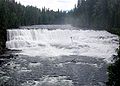
The Murtle River is known for having many waterfalls along its course. Between Murtle Lake and the Clearwater River, the Murtle drops over seven named waterfalls: McDougall
McDougall Falls
McDougall Falls is a waterfall on the Murtle River in Wells Gray Provincial Park, east-central British Columbia, Canada.McDougall Falls is located 5 km downstream from the Diamond Lagoon of Murtle Lake. It is 14 m high. A hiking trail follows the south shore of the Murtle River from the lagoon...
, Meadow
Meadow Falls
Meadow Falls is one of seven waterfalls on the Murtle River west of Murtle Lake in Wells Gray Provincial Park, east-central British Columbia, Canada. Meadow Falls is high....
, Horseshoe
Horseshoe Falls (British Columbia)
Horseshoe Falls is one of seven waterfalls on the Murtle River west of Murtle Lake in Wells Gray Provincial Park, east-central British Columbia, Canada. Horseshoe Falls has two steps, apart; the upper drop is high and the lower and much wider drop is high....
, Majerus
Majerus Falls
Majerus Falls is one of seven waterfalls on the Murtle River west of Murtle Lake in Wells Gray Provincial Park, east-central British Columbia, Canada.Majerus Falls is high and wide, a similar width to Dawson Falls downstream....
, Dawson
Dawson Falls
Dawson Falls is one of seven waterfalls on the Murtle River in Wells Gray Provincial Park, British Columbia, Canada.Dawson Falls was named in 1913 by land surveyor Robert Henry Lee after George Herbert Dawson, the Surveyor-General for British Columbia from 1912-1917...
, The Mushbowl and Helmcken Falls
Helmcken Falls
Helmcken Falls is a waterfall on the Murtle River within Wells Gray Provincial Park in British Columbia, Canada. The protection of Helmcken Falls was one of the reasons for the creation of Wells Gray Provincial Park in 1939....
.
Discovery and naming
There are no records about the Murtle River being known by First Nations. The river was discovered by Joseph HunterJoseph Hunter (Canadian politician)
Joseph Hunter was a Scottish-born surveyor, civil engineer and political figure in British Columbia. He represented Cariboo from 1871 to 1875 and from 1900 to 1904 and Comox from 1890 to 1898 in the Legislative Assembly of British Columbia.He was born in Aberdeen and educated there, concluding his...
, a surveyor working for the future Canadian Pacific Railway
Canadian Pacific Railway
The Canadian Pacific Railway , formerly also known as CP Rail between 1968 and 1996, is a historic Canadian Class I railway founded in 1881 and now operated by Canadian Pacific Railway Limited, which began operations as legal owner in a corporate restructuring in 2001...
, on May 25, 1874. Hunter's expedition rafted across the Clearwater River near The Horseshoe, headed east for about 13 km, and reached the Murtle River upstream from Majerus Falls. He named the river and, a few days later, Murtle Lake for his birthplace in Scotland, Milton of Murtle, near Aberdeen. Between 1872 and 1881, about 20 survey parties fanned out across British Columbia trying to find the best route for the new railway between Yellowhead Pass
Yellowhead Pass
The Yellowhead Pass is a mountain pass across the Continental Divide of the Canadian Rockies. It is located on the border between the Canadian provinces of Alberta and British Columbia, and lies within Jasper National Park and Mount Robson Provincial Park....
in the Rocky Mountains and the Pacific Coast. Three survey parties visited what is now Wells Gray Park. When the more southern Kicking Horse Pass was chosen instead in 1881, all of these meticulously examined routes across the Canadian Cordilleran, including Hunter's, were abandoned. Only three place names in the Park recognize those 10 wasted years of surveys: Murtle River & Lake, Mahood River & Lake
Mahood Lake
Mahood Lake is a lake in the South Cariboo region of the Interior of British Columbia in Wells Gray Provincial Park. It is drained by the Mahood River, a tributary of the Clearwater River which has cut a deep canyon into Cambrian rocks and Pleistocene glacial moraines...
, and Marcus Falls. The latter two refer to James Adam Mahood and Marcus Smith, leaders of two other railway surveys during the 1870s.
It was 40 years before the Murtle River area came under professional scrutiny again, this time by land surveyor Robert Lee. In 1913, he laid out 160 acre lots beside the Murtle River and discovered Helmcken Falls. He was so impressed with the waterfall that he wrote a letter from his remote camp to Sir Richard McBride, British Columbia's premier, asking "may I name the river the McBride River and the falls the McBride Falls in honor of the distinguished Premier of British Columbia?" This ignored the prior naming of the Murtle River by Joseph Hunter. Three weeks later, Lee received a reply of one sentence from the Premier which stated that the waterfall was to be called Helmcken Falls. The McBride River was not mentioned, so Lee thereafter put Murtle River on his maps.
Bridges
The first crossing of the Murtle River was at its narrowest point called The Mushbowl and this was a rickety footbridge built in 1914. A horse bridge was completed in 1928 but it consisted of only two stringers and cross logs with no guard rails, and horses were terrified to cross it. It was damaged by high water in 1936 and replaced. When Arthur Wellesley Gray, after whom Wells Gray Park is named, made his ill-fated tour in 1940, he was overcome by dizziness while crossing this bridge and nearly became the first victim of The Mushbowl. The first road bridge was built in 1949 when the road was being extended to Clearwater Lake and it lasted until 1974. Few visitors during those years could resist stopping for a photograph of that attractive Queen's Truss bridge. The present bridge is a narrow Bailey-type bridge on the same site with the Murtle River roaring through The Mushbowl underneath. It is still the only bridge across the Murtle in its entire length.Geological features
The Murtle River flows across the huge volcanic Murtle Plateau for the last 30 km (18.6 mi) to the Clearwater. The lava erupted about 200,000 years ago from fissuresFissure vent
A fissure vent, also known as a volcanic fissure or simply fissure, is a linear volcanic vent through which lava erupts, usually without any explosive activity. The vent is usually a few meters wide and may be many kilometers long. Fissure vents can cause large flood basalts and lava channels...
near McLeod Hill
McLeod Hill
McLeod Hill is a tuya, located north of Clearwater in the Wells Gray-Clearwater volcanic field in Wells Gray Provincial Park, east-central British Columbia, Canada....
and filled the former valley to depths of up to 250 m (820.2 ft). The extent of this relatively flat surface is best seen from the viewing tower atop Green Mountain.
Pyramid Mountain
Pyramid Mountain (volcano)
Pyramid Mountain is a subglacial mound located on the Murtle Plateau in Wells Gray Provincial Park, east-central British Columbia, Canada.-Formation:...
is a prominent feature beside the Murtle River a few kilometers northeast of the road. It is a subglacial mound
Subglacial mound
A subglacial mound is a type of subglacial volcano. This type of volcano forms when lava erupts beneath a thick glacier or ice sheet. The magma forming these volcanoes was not hot enough to melt a vertical pipe right through the overlying glacial ice, instead forming hyaloclastite and pillow lava...
which erupted under the ice about 12,000 years ago and built its 250 m (820.2 ft) high cone.
Below Helmcken Falls, the Murtle River rushes through Helmcken Canyon for 1.5 km (0.93205910497471 mi) until it meets the Clearwater River. The river is hemmed by sheer lava walls that rise over 200 m (656.2 ft) on each side.
See also
- Clearwater RiverClearwater River (British Columbia)The Clearwater River is the largest tributary of the North Thompson River, joining it at the community of Clearwater, British Columbia. The Clearwater rises from glaciers in the Cariboo Mountains and flows in a mostly southerly direction for to the North Thompson. Its entire course, except the...
- Helmcken FallsHelmcken FallsHelmcken Falls is a waterfall on the Murtle River within Wells Gray Provincial Park in British Columbia, Canada. The protection of Helmcken Falls was one of the reasons for the creation of Wells Gray Provincial Park in 1939....
- Dawson FallsDawson FallsDawson Falls is one of seven waterfalls on the Murtle River in Wells Gray Provincial Park, British Columbia, Canada.Dawson Falls was named in 1913 by land surveyor Robert Henry Lee after George Herbert Dawson, the Surveyor-General for British Columbia from 1912-1917...
- List of British Columbia rivers