
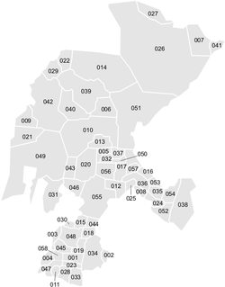
Municipalities of Zacatecas
Encyclopedia
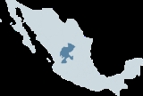
Mexico
The United Mexican States , commonly known as Mexico , is a federal constitutional republic in North America. It is bordered on the north by the United States; on the south and west by the Pacific Ocean; on the southeast by Guatemala, Belize, and the Caribbean Sea; and on the east by the Gulf of...
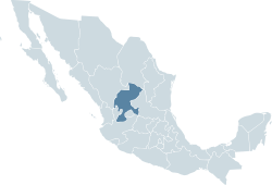
state of Zacatecas
Zacatecas
Zacatecas officially Estado Libre y Soberano de Zacatecas is one of the 31 states which, with the Federal District, comprise the 32 Federal Entities of Mexico. It is divided in 58 municipalities and its capital city is Zacatecas....
is made up of 58 municipalities
Municipality
A municipality is essentially an urban administrative division having corporate status and usually powers of self-government. It can also be used to mean the governing body of a municipality. A municipality is a general-purpose administrative subdivision, as opposed to a special-purpose district...
(municipios).
|- style="text-align:center; background:#d8edff;"
!INEGI
National Institute of Statistics, Geography, and Data Processing
The National Institute of Statistic and Geography is an autonomous agency of the Mexican Government dedicated to coordinate the National System of Statistical and Geographical Information of the country...
code!!Municipality!!Municipal Seat
|-
| 001 || Apozol || Apozol
|-
| 002 || Apulco || Apulco
Apulco
Apulco is a city in the Mexican state of Zacatecas.The city serves as the administrative center for the surrounding municipality of Apulco. Apulco had a 2005 census population of 1,453 people.-Origin of the name:...
|-
| 003 || Atolinga || Atolinga
Atolinga
Atolinga is the seat of Atolinga Municipality in the Mexican state of Zacatecas, located in its southwestern portion.The coordinates of the municipal seat of Atolinga are 21° 44’ 15” north and 103° 28’ 30” west...
|-
| 004 || Florencia de Benito Juárez
Florencia de Benito Juárez
Florencia de Benito Juárez, is a municipality located in the southern extreme of the state of Zacatecas on the edge of the Canyon of Tlaltenango. To the north, the municipality is bordered by the municipality of Atolinga and the state of Jalisco...
|| Florencia de Benito Juárez
Florencia de Benito Juárez
Florencia de Benito Juárez, is a municipality located in the southern extreme of the state of Zacatecas on the edge of the Canyon of Tlaltenango. To the north, the municipality is bordered by the municipality of Atolinga and the state of Jalisco...
|-
| 005 || Calera de Víctor Rosales
Calera de Víctor Rosales
Calera is one of the 58 municipalities in the Mexican state of Zacatecas. It is located on the central part of the state of Zacatecas and it is bounded by the municipalities of General Enrique Estrada, Fresnillo, Villa de Cos, Pánuco, Morelos and Zacatecas. The municipality covers a total surface...
|| Víctor Rosales
|-
| 006 || Cañitas de Felipe Pescador || Cañitas de Felipe Pescador
Cañitas de Felipe Pescador
-History:The first inhabitants of Cañitas de Felipe Pescador where the Huichol Indians. In 1918 the region started to become populated with people who lived on agriculture and grazing animals. In 1921, Governor Donato Moreno granted a motion to legally fund Cañitas with the expropriation of...
|-
| 007 || Concepción del Oro || Concepción del Oro
|-
| 008 || Cuauhtémoc || San Pedro Piedra Gorda
|-
| 009 || Chalchihuites || Chalchihuites
Chalchihuites
Alta Vista, or Chalchihuites, is a small Mesoamerican archaeological site in the Mexican state of Zacatecas, in the northwest of Mexico. The archaeological site of Alta Vista, at Chalchihuites, is located 137 miles to the northwest of the city of Zacatecas and 102 miles southeast of the city of...
|-
| 010 || El Plateado de Joaquín Amaro || El Plateado de Joaquín Amaro
El Plateado de Joaquín Amaro
El Plateado de Joaquín Amaro or Joaquín Amaro, also known as El Plateado and as General Joaquín Amaro, is a community in Zacatecas, Mexico, located 105 km SW of Zacatecas City. It is bordered by the municipal divisions of Villanueva, Tabasco, Momax, and Tlaltenango de Sánchez...
|-
| 011 || El Salvador || El Salvador
|-
| 012 || Fresnillo || Fresnillo
Fresnillo
Fresnillo /fres'nijo/ , founded in 1554 by Francisco de Ibarra, is the second largest city in Zacatecas state, north central Mexico...
|-
| 013 || Genaro Codina || Genaro Codina
|-
| 014 || General Enrique Estrada || General Enrique Estrada
General Enrique Estrada
General Enrique Estrada is a city in the Mexican state of Zacatecas.It was name for General Enrique Estrada....
|-
| 015 || General Francisco R Murguía || Nieves
Nieves
Nieves is a Spanish surname and a female given name from the title of the Virgin Mary Nuestra Señora de las Nieves meaning "Our Lady of the Snows".-People:Notable people with the surname Nieves:* Ángel Nieves Díaz* José Alvarado Nieves...
|-
| 016 || General Pánfilo Natera || General Pánfilo Natera
|-
| 017 || Guadalupe || Guadalupe
Guadalupe, Zacatecas
Guadalupe is the third-largest city in the state of Zacatecas in Mexico. It lies adjacent to the east side of the city of Zacatecas and is a component of the Zacatecas-Guadalupe metropolitan area. The city had a 2005 census population of 99,572 inhabitants and serves as municipal seat of the...
|-
| 018 || Huanusco || Huanusco
Huanusco
The municipality of Huanusco is located in the southwestern portion of the Mexican state of Zacatecas.Its coordinaates are 21° 46' north latitude and 102° 58' west longitude. The average elevation of the municipality is 500 meters above sea level and the municipality covers an area of roughly...
|-
| 019 || Jalpa || Jalpa
Jalpa, Zacatecas
Founded in the early 15th Century by Spanish explorers in search of Gold and Silver, Jalpa was spelled "Xalpa" by its native Indian Caxcan, Chichimeca and huichole people. Conquered by the Spanish the Indian population inter-mixed with Spanish and other European peoples to form today's meztisos...
|-
| 020 || Jerez de García Salinas
Jerez de García Salinas
The city and surrounding municipality of Jerez is located in the center of the state of Zacatecas, Mexico. Jerez de García Salinas is the name of the city and "Jerez" of the municipality....
|| Jerez
Jerez de García Salinas
The city and surrounding municipality of Jerez is located in the center of the state of Zacatecas, Mexico. Jerez de García Salinas is the name of the city and "Jerez" of the municipality....
|-
| 021 || Jiménez del Teul || Jiménez del Teul
|-
| 022 || Juan Aldama
Municipality of Juan Aldama
The Municipality of Juan Aldama was named in honor of the insurgent Juan Aldama, who participated alongside Miguel Hidalgo in the Mexican War of Independence...
|| Juan Aldama, Zacatecas
Juan Aldama, Zacatecas
Juan Aldama is a city in the northwestern portion of the Mexican state of Zacatecas. It is the biggest community in the Municipality of Juan Aldama and the seat of the municipal government.It was renamed for insurgent Juan Aldama...
|-
| 023 || Juchipila || Juchipila
|-
| 024 || Loreto || Loreto
Loreto, Zacatecas
Loreto is a town in Loreto Municipality, Zacatecas. The town is the seventh-largest community in the state, with a 2005 census population of 22,085 inhabitants, while the municipality of which it serves as municipal seat had a population of 43,411...
|-
| 025 || Luis Moya || Luis Moya, Zacatecas
|-
| 026 || Mazapil || Mazapil
|-
| 027 || Melchor Ocampo || Melchor Ocampo
|-
| 028 || Mezquital del Oro || Mezquital del Oro
|-
| 029 || Miguel Auza || Miguel Auza, Zacatecas
|-
| 030 || Momax || Momax
|-
| 031 || Monte Escobedo || Monte Escobedo
|-
| 032 || Morelos || Morelos
|-
| 033 || Moyahua de Estrada || Moyahua de Estrada
|-
| 034 || Nochistlán de Mejía || Nochistlán de Mejía
|-
| 035 || Noria de Ángeles || Noria de Ángeles
|-
| 036 || Ojocaliente || Ojocaliente
|-
| 037 || Pánuco || Pánuco
|-
| 038 || Pinos || Pinos
|-
| 039 || Río Grande || Río Grande
Rio Grande
The Rio Grande is a river that flows from southwestern Colorado in the United States to the Gulf of Mexico. Along the way it forms part of the Mexico – United States border. Its length varies as its course changes...
|-
| 040 || Santa María de la Paz
Municipality of Santa María de la Paz
The Municipality of Santa Maria de la Paz formerly known as Ignacio de Allende, is located in the southern part of the state of Zacatecas Mexico. It is located between the Municipality of Teúl de González Ortega and the Municipality of Tepechitlán along federal highway 23...
|| Santa María de la Paz
|-
| 041 || El Salvador || El Salvador
El Salvador
El Salvador or simply Salvador is the smallest and the most densely populated country in Central America. The country's capital city and largest city is San Salvador; Santa Ana and San Miguel are also important cultural and commercial centers in the country and in all of Central America...
|-
| 042 || Sombrerete || Sombrerete
Sombrerete, Zacatecas
Sombrerete is a colonial city and its surrounding municipality of the same name located in western part of the Mexican state of Zacatecas.Known for being a picturesque city and for its large deposits of mineral ores, discovered in the sixteenth century...
|-
| 043 || Susticacán || Susticacán
|-
| 044 || Tabasco || Tabasco
Tabasco, Zacatecas
Tabasco is a small town in the state of Zacatecas, Mexico....
|-
| 045 || Tepechitlán || Tepechitlán
Tepechitlán
The municipality of Tepechitlán is located in the southwestern portion of the Mexican state of Zacatecas. It is located between 21º33'49" and 21º44'00" latitude north and 103º09'07" and 103º32'01" longitude west with an average altitude of approximately 1700 meters above sea level...
|-
| 046 || Tepetongo || Tepetongo
Tepetongo
The municipality of Tepetongo is located in the southwestern portion of the Mexican state of Zacatecas.-Population:The population varies from year to year increasing or decreasing but always hovering around 20,000 including those of surrounding villages and ranches.While the area itself once had a...
|-
| 047 || Teúl de González Ortega || Teúl de González Ortega
Teúl de González Ortega
Teúl de González Ortega is a municipality in the south of the state of Zacatecas, Mexico-History:Prior to Spanish conquest and colonization of El Teúl, the town and its surrounding valleys were primarily inhabited by Caxcan peoples...
|-
| 048 || Tlaltenango de Sánchez Román || Tlaltenango de Sánchez Román
Tlaltenango de Sánchez Román
The municipality of Tlaltenango de Sánchez Román is located in the southwestern portion of the Mexican state of Zacatecas. The average elevation of the municipality is 1,723 meters above sea level and the municipality covers an area of...
|-
| 049 || Valparaiso || Valparaiso
Valparaíso
Valparaíso is a city and commune of Chile, center of its third largest conurbation and one of the country's most important seaports and an increasing cultural center in the Southwest Pacific hemisphere. The city is the capital of the Valparaíso Province and the Valparaíso Region...
|-
| 050 || Trinidad García de la Cadena || Trinidad García de la Cadena
|-
| 051 || Valparaíso || Valparaíso
Valparaíso, Zacatecas
Valparaíso is a town in the north central Mexican state of Zacatecas. It is located at on the interior plateau, 70 mi/113 km E of Zacatecas, at an elevation of 6200 ft/1890m...
|-
| 052 || Vetagrande || Vetagrande
|-
| 053 || Villa de Cos || Villa de Cos
|-
| 054 || [Municipality of Villa García|Villa García
Villa Garcia Zacatecas
Villa García is one of the 58 municipalities of the state of Zacatecas.It is located 140 kilometers from the city of Zacatecas.Villa García borders the municipality of Loreto in the north, Pinos in the south east. The states of Aguascalientes in the east and Jalisco in the south.Villa García has a...
|| Villa García
Villa García
Villa García - Manga Rural is a barrio of Montevideo, Uruguay.- External links :***...
|-
| 055 || Villa González Ortega || Villa González Ortega
|-
| 056 || Villa Hidalgo
Villa Hidalgo, Zacatecas
Villa Hidalgo is a village in Zacatecas, Mexico....
|| Villa Hidalgo
Villa Hidalgo, Zacatecas
Villa Hidalgo is a village in Zacatecas, Mexico....
|-
| 057 || Villanueva || Villanueva
Villanueva, Zacatecas
Villanueva is a town in the state of Zacatecas, Mexico. It is the administrative seat of the Municipality of Villanueva.-Name:Villanueva was founded on February 4, 1692 under the name Villagutierre del Águila. Like many towns in Mexico the name of the patron saint of the town was added to the name...
|-
| 058 || Zacatecas || Zacatecas
Zacatecas, Zacatecas
Zacatecas is a city and municipality in Mexico and the capital of the state of Zacatecas. It is located in the north central part of the country. The city had its start as a Spanish mining camp in the mid 16th century. Prior to this, the area's rich deposits in silver and other minerals were known...
|}
Defunct municipalities
SaucedaSierra Hermosa
Tenayuca