Municipal Borough of Romford
Encyclopedia
Romford was a local government district in southwest Essex
from 1851 to 1965. It was significantly expanded in 1934 and gained the status of municipal borough
in 1937. The population density of the district consistently increased during its existence and its former area now corresponds to the northern part of the London Borough of Havering in Greater London
.
, becoming a civil parish in its own right in 1849. In 1851 a local board of health
was set up for the parish; although its area was reduced in 1855 to cover only the town. The local board convened at St Edward's Hall in Laurie Square from 1851 to 1853 and used the old liberty court house from 1853 to 1869. From 1869 it was based in offices in the marketplace and finally purchased the old court house in 1892. In 1894 the local board's area became Romford urban district
as part of the Local Government Act 1894
. This caused the parish to be divided into Romford Urban and Romford Rural, with the outer part becoming a component of Romford Rural District
.
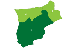
 From 1894 to 1900 the urban district consisted of the civil parish of Romford Urban. In 1900 the two Romford parishes were recombined and the urban district was expanded to cover the reconstituted parish of Romford from 1900 to 1934. The urban district was surrounded by Romford Rural District until 1934 when the rural district was abolished and the urban district gained the parishes of Noak Hill
and Havering-atte-Bower
. The urban district council continued to meet at the old court house until in was demolished in 1933. The Romford urban district was incorporated as a municipal borough in 1937 and the council moved to a new town hall on Main Road (formerly Hare Street).
considered the borough for inclusion in Greater London and in 1965 the municipal borough was abolished by the London Government Act 1963
. Its former area was transferred to Greater London from Essex and combined with that of Hornchurch Urban District
to form the present-day London Borough of Havering
.
Essex
Essex is a ceremonial and non-metropolitan county in the East region of England, and one of the home counties. It is located to the northeast of Greater London. It borders with Cambridgeshire and Suffolk to the north, Hertfordshire to the west, Kent to the South and London to the south west...
from 1851 to 1965. It was significantly expanded in 1934 and gained the status of municipal borough
Municipal borough
Municipal boroughs were a type of local government district which existed in England and Wales between 1835 and 1974, in Northern Ireland from 1840 to 1973 and in the Republic of Ireland from 1840 to 2002...
in 1937. The population density of the district consistently increased during its existence and its former area now corresponds to the northern part of the London Borough of Havering in Greater London
Greater London
Greater London is the top-level administrative division of England covering London. It was created in 1965 and spans the City of London, including Middle Temple and Inner Temple, and the 32 London boroughs. This territory is coterminate with the London Government Office Region and the London...
.
Background and formation
Romford had formed a chapelry in the historic Liberty of HaveringRoyal Liberty of Havering
Havering, also known as Havering-atte-Bower, was a royal manor and ancient liberty whose former area now forms part of, and gives its name to, the London Borough of Havering in Greater London...
, becoming a civil parish in its own right in 1849. In 1851 a local board of health
Local board of health
Local Boards or Local Boards of Health were local authorities in urban areas of England and Wales from 1848 to 1894. They were formed in response to cholera epidemics and were given powers to control sewers, clean the streets, regulate slaughterhouses and ensure the proper supply of water to their...
was set up for the parish; although its area was reduced in 1855 to cover only the town. The local board convened at St Edward's Hall in Laurie Square from 1851 to 1853 and used the old liberty court house from 1853 to 1869. From 1869 it was based in offices in the marketplace and finally purchased the old court house in 1892. In 1894 the local board's area became Romford urban district
Urban district
In the England, Wales and Ireland, an urban district was a type of local government district that covered an urbanised area. Urban districts had an elected Urban District Council , which shared local government responsibilities with a county council....
as part of the Local Government Act 1894
Local Government Act 1894
The Local Government Act 1894 was an Act of the Parliament of the United Kingdom that reformed local government in England and Wales outside the County of London. The Act followed the reforms carried out at county level under the Local Government Act 1888...
. This caused the parish to be divided into Romford Urban and Romford Rural, with the outer part becoming a component of Romford Rural District
Romford Rural District
Romford Rural District was a local government district in south west Essex, England from 1894 to 1934. It surrounded, but did not include, Romford which formed a separate urban district...
.
District and borough

Noak Hill
Noak Hill is a village in the London Borough of Havering. It is in the far north east of the borough close to the Greater London boundary which is locally the M25 motorway, situated on hilly terrain. The village consists of various period homes, many of which are listed, a 19th century church and...
and Havering-atte-Bower
Havering-atte-Bower
Havering-atte-Bower is a village and outlying settlement of the London Borough of Havering, located 15 miles northeast of Charing Cross and close to the Greater London boundary. It was one of three former parishes whose area comprised the historic Royal Liberty of Havering...
. The urban district council continued to meet at the old court house until in was demolished in 1933. The Romford urban district was incorporated as a municipal borough in 1937 and the council moved to a new town hall on Main Road (formerly Hare Street).
Abolition
The Royal Commission on Local Government in Greater LondonRoyal Commission on Local Government in Greater London
The Royal Commission on Local Government in Greater London, also known as the Herbert Commission, was established in 1957 and published its report in 1960...
considered the borough for inclusion in Greater London and in 1965 the municipal borough was abolished by the London Government Act 1963
London Government Act 1963
The London Government Act 1963 is an Act of the Parliament of the United Kingdom, which recognised officially the conurbation known as Greater London and created a new local government structure for the capital. The Act significantly reduced the number of local government districts in the area,...
. Its former area was transferred to Greater London from Essex and combined with that of Hornchurch Urban District
Hornchurch Urban District
Hornchurch was a local government district in south west Essex, England from 1926 to 1965. The urban district council was based at Langtons House. The district formed a suburb of London and was expanded in 1934...
to form the present-day London Borough of Havering
London Borough of Havering
The London Borough of Havering is a London borough in North East London, England and forms part of Outer London. The principal town in Havering is Romford and the other main communities are Hornchurch, Upminster and Rainham. The borough is mainly characterised by suburban development with large...
.
Population
| Year | 1901 | 1911 | 1921 | 1931 | 1941 | 1951 | 1961 | 2010 |
|---|---|---|---|---|---|---|---|---|
| Population | 13,656 | 16,970 | 19,442 | 35,918 | 88,002 | 114,584 | 194 |

