
London Government Act 1963
Encyclopedia
The London Government Act 1963 (c. 33) is an Act
of the Parliament of the United Kingdom
, which recognised officially the conurbation
known as Greater London
and created a new local government
structure for the capital. The Act significantly reduced the number of local government districts in the area, resulting in local authorities responsible for larger areas and populations. The upper tier of local government was reformed to cover the whole of the Greater London area and with a more strategic role; and the split of functions between upper and lower tiers was recast. The Act classified the boroughs into inner
and outer London
groups. The City of London
and its corporation were essentially unreformed by the legislation. Subsequent amendments to the Act have significantly amended the upper tier arrangements, with the Greater London Council
constituted in the legislation replaced by the Greater London Authority
. As of 2008, the London boroughs are more or less identical to those created in 1965, although with some enhanced powers over services such as waste management and education.
(GLC), 32 new London borough councils and the existing City of London
. The provisions of the Act came into effect on 1 April 1965, the new councils having been elected as "shadow authorities" in 1964.
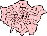
Section 1 of the Act established 32 London boroughs, each of which was to be governed by an elected borough council, and was to be regulated by the Municipal Corporations Act 1882
and Local Government Act 1933
. Twelve of the boroughs, corresponding to the former County of London, were designated Inner London boroughs. The remaining twenty boroughs were designated Outer London boroughs. None of the boroughs were given names in the Act.
Section 2 declared that the area comprising the areas of the London boroughs, the City and the Temples shall constitute an administrative area to be known as Greater London. An elected Greater London Council was to govern the new area.
Section 3 abolished the administrative counties
of Middlesex
and London
(created in 1889), and absorbed parts of Kent
, Essex
, Surrey
and Hertfordshire
plus the whole of the City of London
to form the administrative area of Greater London. As well the two counties, the twenty-eight existing metropolitan borough
s, plus all county borough
s, county districts or parishes
that fell wholly within Greater London were to cease to exist, along with their councils. No part of Greater London was to form part of any administrative county, county district or parish. Three Middlesex urban districts not included in Greater London were transferred to other counties: Potters Bar
to Hertfordshire
and Staines
and Sunbury-on-Thames
to Surrey
.
The Act also established the Inner London Education Authority
to administer schools and colleges in the 12 inner London boroughs. The remaining 20 outer boroughs became local education authorities
in their own right. The London Traffic Area
and the London and Home Counties Traffic Advisory Committee
, set up in 1924, were abolished, with the GLC gaining powers to regulate road traffic. An alteration was also made to the Metropolitan Police District
to include the whole of Greater London, but the district continued to include a number of areas in surrounding counties.
Later the Local Government Act 1985
would abolish the GLC and devolve its functions to the London boroughs and to central government.
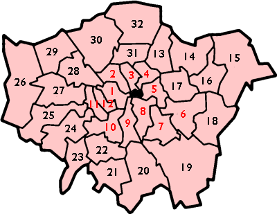 The composition of the London boroughs was given in Schedule 1 of the Act:
Nine names were without controversy and were proposed in September, 1963.
Six new names were proposed by the Minister in October, 1963 for boroughs unable to decide upon a name
The Minister proposed a further twelve names in January, 1964
Chelsea was unwilling to lose its name, and the Royal Borough of Kensington and Chelsea
was the only double-barrelled name to be permitted. The name "Royal Borough of Charlton
" was proposed for Greenwich/Woolwich (Borough 6), whilst Lewisham and Deptford (Borough 7) were also unable to agree on whether the borough should be named Lewisham, Deptford or Ravensbourne. The councils to become part of the London Borough of Barnet
(Borough 30) suggested "Northgate" or "Northern Heights" as names. Islington and Finsbury (Borough 3) were also unable to come to a decision, with Finsbury preferring "New River" and Islington preferring Islington. Richmond and Twickenham
(Borough 24) disagreed over which, if any of those names should appear in the new borough names. Suggestions for Enfield
(Borough 32) included "Enfield Chase
" and "Edmonton Hundred
".
The Local Government Act 1972
would later provide a mechanism for councils to change their names, and both the London Borough of Hammersmith and the London Borough of Barking changed their names after their creation to contain a second locality: to "Hammersmith and Fulham" and "Barking and Dagenham", respectively.
was appointed in 1957 under the chairmanship of Sir Edwin Herbert to consider future local government structures in Greater London. The commission delivered its report in October 1960 proposing the creation of a Greater London with 52 Greater London Boroughs.
The Greater London area set up by the 1963 Act was very similar to that proposed by the Herbert Report, with the exclusion of Banstead
, Caterham and Warlingham
, Esher
, Walton and Weybridge
in Surrey, Chigwell
in Essex, Cheshunt
in Hertfordshire
, and Staines
and Sunbury
in Middlesex.
Outside the county of London area the boroughs were to be:
The Minister of Housing and Local Government announced that Cheshunt, Chigwell, Esher, Staines and Sunbury were to be excluded from Greater London on 18 May 1961, having already announced the exclusion of Banstead
, Caterham and Warlingham
and Walton and Weybridge. The requests by Romford, Barnet, Carshalton, Coulsdon and Purley, Feltham, and Yiewsley and West Drayton to be removed from the area were turned down. Additionally, it was stated that the "northern part of the borough of Epsom and Ewell definitely forms part of Greater London and must be included", although Epsom
was to be excluded. Epsom and Ewell would ultimately be excluded from the area in its entirety.
Changes published in August 1962 saw a reduction from 33 to 32 boroughs with the association of Clapham/Streatham with the London Borough of Lambeth
; Shoreditch joining Hackney
- also Wanstead and Woodford would be added to Ilford to form the London Borough of Redbridge
rather than the London Borough of Waltham Forest
; Chislehurst and Sidcup would be divided between the London Borough of Bromley
and the London Borough of Bexley
, and that East Barnet
, Friern Barnet
, Hendon
, and Finchley
would form a single London Borough of Barnet
, and that Enfield would join Edmonton and Southgate (in the London Borough of Enfield
), and the association of Tottenham, Hornsey and Wood Green (to form the London Borough of Haringey
).
The Local Government Bill was finally published in November 1962 proposed essentially the 32 London boroughs that were created.
Act of Parliament
An Act of Parliament is a statute enacted as primary legislation by a national or sub-national parliament. In the Republic of Ireland the term Act of the Oireachtas is used, and in the United States the term Act of Congress is used.In Commonwealth countries, the term is used both in a narrow...
of the Parliament of the United Kingdom
Parliament of the United Kingdom
The Parliament of the United Kingdom of Great Britain and Northern Ireland is the supreme legislative body in the United Kingdom, British Crown dependencies and British overseas territories, located in London...
, which recognised officially the conurbation
Conurbation
A conurbation is a region comprising a number of cities, large towns, and other urban areas that, through population growth and physical expansion, have merged to form one continuous urban and industrially developed area...
known as Greater London
Greater London
Greater London is the top-level administrative division of England covering London. It was created in 1965 and spans the City of London, including Middle Temple and Inner Temple, and the 32 London boroughs. This territory is coterminate with the London Government Office Region and the London...
and created a new local government
Local government
Local government refers collectively to administrative authorities over areas that are smaller than a state.The term is used to contrast with offices at nation-state level, which are referred to as the central government, national government, or federal government...
structure for the capital. The Act significantly reduced the number of local government districts in the area, resulting in local authorities responsible for larger areas and populations. The upper tier of local government was reformed to cover the whole of the Greater London area and with a more strategic role; and the split of functions between upper and lower tiers was recast. The Act classified the boroughs into inner
Inner London
Inner London is the name for the group of London boroughs which form the interior part of Greater London and are surrounded by Outer London. The area was first officially defined in 1965 and for purposes such as statistics, the definition has changed over time. The terms Inner London and Central...
and outer London
Outer London
Outer London is the name for the group of London Boroughs that form a ring around Inner London.These were areas that were not part of the County of London and became formally part of Greater London in 1965...
groups. The City of London
City of London
The City of London is a small area within Greater London, England. It is the historic core of London around which the modern conurbation grew and has held city status since time immemorial. The City’s boundaries have remained almost unchanged since the Middle Ages, and it is now only a tiny part of...
and its corporation were essentially unreformed by the legislation. Subsequent amendments to the Act have significantly amended the upper tier arrangements, with the Greater London Council
Greater London Council
The Greater London Council was the top-tier local government administrative body for Greater London from 1965 to 1986. It replaced the earlier London County Council which had covered a much smaller area...
constituted in the legislation replaced by the Greater London Authority
Greater London Authority
The Greater London Authority is the top-tier administrative body for Greater London, England. It consists of a directly elected executive Mayor of London, currently Boris Johnson, and an elected 25-member London Assembly with scrutiny powers...
. As of 2008, the London boroughs are more or less identical to those created in 1965, although with some enhanced powers over services such as waste management and education.
Provisions of the Act
The Act set up a two-tier local government system, with powers divided between the newly formed Greater London CouncilGreater London Council
The Greater London Council was the top-tier local government administrative body for Greater London from 1965 to 1986. It replaced the earlier London County Council which had covered a much smaller area...
(GLC), 32 new London borough councils and the existing City of London
City of London
The City of London is a small area within Greater London, England. It is the historic core of London around which the modern conurbation grew and has held city status since time immemorial. The City’s boundaries have remained almost unchanged since the Middle Ages, and it is now only a tiny part of...
. The provisions of the Act came into effect on 1 April 1965, the new councils having been elected as "shadow authorities" in 1964.
Section 1 of the Act established 32 London boroughs, each of which was to be governed by an elected borough council, and was to be regulated by the Municipal Corporations Act 1882
Municipal Corporations Act 1882
The Municipal Corporations Act 1882 was an Act of the Parliament of the United Kingdom. It replaced existing legislation governing municipal boroughs in England and Wales, and gave the corporations powers to make byelaws and to acquire land and buildings. Municipal boroughs continued to be...
and Local Government Act 1933
Local Government Act 1933
The Local Government Act 1933 was an Act of the Parliament of the United Kingdom that consolidated and revised existing legislation that regulated local government in England and Wales...
. Twelve of the boroughs, corresponding to the former County of London, were designated Inner London boroughs. The remaining twenty boroughs were designated Outer London boroughs. None of the boroughs were given names in the Act.
Section 2 declared that the area comprising the areas of the London boroughs, the City and the Temples shall constitute an administrative area to be known as Greater London. An elected Greater London Council was to govern the new area.
Section 3 abolished the administrative counties
Administrative counties of England
Administrative counties were a level of subnational division of England used for the purposes of local government from 1889 to 1974. They were created by the Local Government Act 1888 as the areas for which county councils were elected. Some large counties were divided into several administrative...
of Middlesex
Middlesex
Middlesex is one of the historic counties of England and the second smallest by area. The low-lying county contained the wealthy and politically independent City of London on its southern boundary and was dominated by it from a very early time...
and London
County of London
The County of London was a county of England from 1889 to 1965, corresponding to the area known today as Inner London. It was created as part of the general introduction of elected county government in England, by way of the Local Government Act 1888. The Act created an administrative County of...
(created in 1889), and absorbed parts of Kent
Kent
Kent is a county in southeast England, and is one of the home counties. It borders East Sussex, Surrey and Greater London and has a defined boundary with Essex in the middle of the Thames Estuary. The ceremonial county boundaries of Kent include the shire county of Kent and the unitary borough of...
, Essex
Essex
Essex is a ceremonial and non-metropolitan county in the East region of England, and one of the home counties. It is located to the northeast of Greater London. It borders with Cambridgeshire and Suffolk to the north, Hertfordshire to the west, Kent to the South and London to the south west...
, Surrey
Surrey
Surrey is a county in the South East of England and is one of the Home Counties. The county borders Greater London, Kent, East Sussex, West Sussex, Hampshire and Berkshire. The historic county town is Guildford. Surrey County Council sits at Kingston upon Thames, although this has been part of...
and Hertfordshire
Hertfordshire
Hertfordshire is a ceremonial and non-metropolitan county in the East region of England. The county town is Hertford.The county is one of the Home Counties and lies inland, bordered by Greater London , Buckinghamshire , Bedfordshire , Cambridgeshire and...
plus the whole of the City of London
City of London
The City of London is a small area within Greater London, England. It is the historic core of London around which the modern conurbation grew and has held city status since time immemorial. The City’s boundaries have remained almost unchanged since the Middle Ages, and it is now only a tiny part of...
to form the administrative area of Greater London. As well the two counties, the twenty-eight existing metropolitan borough
Metropolitan borough
A metropolitan borough is a type of local government district in England, and is a subdivision of a metropolitan county. Created in 1974 by the Local Government Act 1972, metropolitan boroughs are defined in English law as metropolitan districts, however all of them have been granted or regranted...
s, plus all county borough
County borough
County borough is a term introduced in 1889 in the United Kingdom of Great Britain and Ireland , to refer to a borough or a city independent of county council control. They were abolished by the Local Government Act 1972 in England and Wales, but continue in use for lieutenancy and shrievalty in...
s, county districts or parishes
Civil parish
In England, a civil parish is a territorial designation and, where they are found, the lowest tier of local government below districts and counties...
that fell wholly within Greater London were to cease to exist, along with their councils. No part of Greater London was to form part of any administrative county, county district or parish. Three Middlesex urban districts not included in Greater London were transferred to other counties: Potters Bar
Potters Bar Urban District
South Mimms Rural District and Potters Bar Urban District were local government districts occupying the area around the town of Potters Bar, England....
to Hertfordshire
Hertfordshire
Hertfordshire is a ceremonial and non-metropolitan county in the East region of England. The county town is Hertford.The county is one of the Home Counties and lies inland, bordered by Greater London , Buckinghamshire , Bedfordshire , Cambridgeshire and...
and Staines
Staines Urban District
Staines was a local government district from 1894 to 1974 around the town of Staines. Apart from Staines itself, it also covered Ashford, Laleham and Stanwell....
and Sunbury-on-Thames
Sunbury-on-Thames Urban District
Sunbury on Thames - also known as Sunbury - was a local government district from 1894 to 1974 around the town of Sunbury-on-Thames, also covering Littleton and Shepperton....
to Surrey
Surrey
Surrey is a county in the South East of England and is one of the Home Counties. The county borders Greater London, Kent, East Sussex, West Sussex, Hampshire and Berkshire. The historic county town is Guildford. Surrey County Council sits at Kingston upon Thames, although this has been part of...
.
The Act also established the Inner London Education Authority
Inner London Education Authority
The Inner London Education Authority was the education authority for the 12 inner London boroughs from 1965 until its abolition in 1990.-History:...
to administer schools and colleges in the 12 inner London boroughs. The remaining 20 outer boroughs became local education authorities
Local Education Authority
A local education authority is a local authority in England and Wales that has responsibility for education within its jurisdiction...
in their own right. The London Traffic Area
London Traffic Area
The London Traffic Area was established by the London Traffic Act 1924 in order to regulate the increasing amount of motor traffic in the London area...
and the London and Home Counties Traffic Advisory Committee
London and Home Counties Traffic Advisory Committee
The London and Home Counties Traffic Advisory Committee was established in 1924 to advise the Minister of Transport on issues concerning traffic and transport in the London Traffic Area. It was abolished in 1965....
, set up in 1924, were abolished, with the GLC gaining powers to regulate road traffic. An alteration was also made to the Metropolitan Police District
Metropolitan Police District
The Metropolitan Police District is the police area which is policed by London's Metropolitan Police Service. It currently consists of Greater London, excluding the City of London.-History:...
to include the whole of Greater London, but the district continued to include a number of areas in surrounding counties.
Later the Local Government Act 1985
Local Government Act 1985
The Local Government Act 1985 is an Act of Parliament in the United Kingdom. Its main effect was to abolish the county councils of the metropolitan counties that had been set up in 1974 by the Local Government Act 1972, along with the Greater London Council that had been established in 1965.The...
would abolish the GLC and devolve its functions to the London boroughs and to central government.
The boroughs
- The metropolitan boroughs of WestminsterMetropolitan Borough of WestminsterThe Metropolitan Borough of Westminster was a metropolitan borough in the County of London, England, from 1900 to 1965.-City Status:By royal charter dated 29 October 1900 the borough was granted the title City of Westminster. Westminster had originally been created a city and seat of the...
, PaddingtonMetropolitan Borough of PaddingtonThe Metropolitan Borough of Paddington was a Metropolitan borough of the County of London between 1900 and 1965.-History:Its area covered that part of the current City of Westminster west of Edgware Road and Maida Vale, and north of Bayswater Road. Places in the borough included Paddington,...
and St MaryleboneMetropolitan Borough of St MaryleboneThe Metropolitan Borough of St Marylebone was a Metropolitan borough of the County of London from 1900 to 1965. It was based directly on the previously existing civil parish of St Marylebone, which was incorporated into the Metropolitan Board of Works area in 1855, retaining a parish vestry, and...
. - The metropolitan boroughs of HampsteadMetropolitan Borough of HampsteadThe Metropolitan Borough of Hampstead was a Metropolitan borough of the County of London from 1900 to 1965, when it was amalgamated with the Metropolitan Borough of St Pancras and the Metropolitan Borough of Holborn to form the London Borough of Camden....
, HolbornMetropolitan Borough of HolbornThe Metropolitan Borough of Holborn was a Metropolitan borough in the County of London between 1900 and 1965, when it was amalgamated with the Metropolitan Borough of St Pancras and the Metropolitan Borough of Hampstead to form the London Borough of Camden....
and St PancrasMetropolitan Borough of St PancrasThe Metropolitan Borough of St Pancras was a Metropolitan borough of the County of London between 1900 and 1965, when it was amalgamated with the Metropolitan Borough of Hampstead and the Metropolitan Borough of Holborn to form the London Borough of Camden...
. - The metropolitan boroughs of FinsburyMetropolitan Borough of FinsburyThe Metropolitan Borough of Finsbury was a Metropolitan borough within the County of London from 1900 to 1965, when it was amalgamated with the Metropolitan Borough of Islington to form the London Borough of Islington.- Boundaries :...
and IslingtonMetropolitan Borough of IslingtonThe Metropolitan Borough of Islington was a Metropolitan borough within the County of London from 1900 to 1965, when it was amalgamated with the Metropolitan Borough of Finsbury to form the London Borough of Islington.-Boundaries:...
. - The metropolitan boroughs of HackneyMetropolitan Borough of HackneyThe Metropolitan Borough of Hackney was a Metropolitan borough of the County of London from 1900 to 1965. Its area became part of the London Borough of Hackney.-Formation and boundaries:...
, ShoreditchMetropolitan Borough of ShoreditchThe Metropolitan Borough of Shoreditch was a Metropolitan borough of the County of London between 1900 and 1965, when it was merged with the Metropolitan Borough of Stoke Newington and the Metropolitan Borough of Hackney to form the London Borough of Hackney....
and Stoke NewingtonMetropolitan Borough of Stoke NewingtonThe Metropolitan Borough of Stoke Newington was a metropolitan borough in the County of London between 1900 and 1965 when it became part of the London Borough of Hackney.-Predecessor authorities:...
. - The metropolitan boroughs of Bethnal GreenMetropolitan Borough of Bethnal GreenBethnal Green was a civil parish and a metropolitan borough in the East End of London, England. It was formed as a civil parish in 1743 from the Bethnal Green hamlet in Stepney ancient parish. The vestry became an electing authority to the Metropolitan Board of Works in 1855 and in 1889 it became...
, PoplarMetropolitan Borough of PoplarPoplar was a local government district in the metropolitan area of London, England. It was formed as a district of the Metropolis in 1855 and became a metropolitan borough in the County of London in 1900. It comprised the civil parishes of Bow, Bromley and Poplar until 1907, when it also became a...
and StepneyMetropolitan Borough of StepneyThe Metropolitan Borough of Stepney was a Metropolitan borough in the County of London created in 1900. In 1965 it became part of the London Borough of Tower Hamlets.-Boundaries:...
. - The metropolitan borough of GreenwichMetropolitan Borough of GreenwichThe Metropolitan Borough of Greenwich was a Metropolitan borough in the County of London between 1900 and 1965. Within the area of the borough were the Royal Naval College , the Royal Observatory and Greenwich Park. It bordered the boroughs of Woolwich, Deptford, Lewisham...
and so much of the metropolitan borough of WoolwichMetropolitan Borough of WoolwichThe Metropolitan Borough of Woolwich was a Metropolitan borough in the County of London from 1900 to 1965.-Formation:The borough was formed from the civil parishes :*Eltham *Plumstead...
as lay south of the centre of the navigable channel of the River ThamesRiver ThamesThe River Thames flows through southern England. It is the longest river entirely in England and the second longest in the United Kingdom. While it is best known because its lower reaches flow through central London, the river flows alongside several other towns and cities, including Oxford,...
at low water. - The metropolitan boroughs of DeptfordMetropolitan Borough of DeptfordThe Metropolitan Borough of Deptford was a Metropolitan borough in the County of London between 1900 and 1965, when it became part of the London Borough of Lewisham along with the Metropolitan Borough of Lewisham....
and LewishamMetropolitan Borough of LewishamThe Metropolitan Borough of Lewisham was a Metropolitan borough in the County of London between 1900 and 1965, when it became part of the London Borough of Lewisham along with the Metropolitan Borough of Deptford.-History:...
. - The metropolitan boroughs of BermondseyMetropolitan Borough of BermondseyThe Metropolitan Borough of Bermondsey was a Metropolitan borough in the County of London, created in 1900 by the London Government Act 1899. It was abolished and its area became part of the London Borough of Southwark in 1965.-History:...
, CamberwellMetropolitan Borough of CamberwellCamberwell was a civil parish and metropolitan borough in the County of London. The borough was created in 1900 by the London Government Act 1899, covering the area of the ancient parish of Camberwell...
and SouthwarkMetropolitan Borough of SouthwarkThe Metropolitan Borough of Southwark was a metropolitan borough in the County of London from 1900 to 1965. It was created to cover the western section of the ancient borough of Southwark and formed the northwestern part of the current London Borough of Southwark. In common with the rest of inner...
. - The metropolitan borough of LambethMetropolitan Borough of LambethThe Metropolitan Borough of Lambeth was a Metropolitan borough under London County Council from 1900 to 1965.-History:The borough covered the area of the former Lambeth parish vestry. In addition to the historic riverside area of Lambeth, this included Kennington, Vauxhall, Stockwell, Brixton, the...
and so much of the metropolitan borough of WandsworthMetropolitan Borough of WandsworthThe Metropolitan Borough of Wandsworth was a Metropolitan borough under the London County Council, from 1900 to 1965.The borough was formed from five civil parishes: Clapham, Putney, Streatham, Tooting Graveney and Wandsworth...
as lay east of Hazelbourne Road, Cavendish Road, the railway between Balham and Streatham Common stations and the railway between Streatham and Mitcham Junction stations. - The metropolitan borough of BatterseaMetropolitan Borough of BatterseaBattersea was a civil parish and metropolitan borough in the County of London, England. In 1965 the borough was abolished and its area combined with parts of the Metropolitan Borough of Wandsworth to form the London Borough of Wandsworth...
and the remainder of the metropolitan borough of Wandsworth not included in borough 9. - The metropolitan boroughs of FulhamMetropolitan Borough of FulhamThe Metropolitan Borough of Fulham was a Metropolitan borough in the County of London between 1900 and 1965, when it was merged with the Metropolitan Borough of Hammersmith to form the London Borough of Hammersmith and Fulham. It was a riverside borough, and included the areas of Fulham, West...
and HammersmithMetropolitan Borough of HammersmithThe Metropolitan Borough of Hammersmith was, between 1900 and 1965, a Metropolitan borough of the County of London. It included Hammersmith, Wormwood Scrubs, Old Oak Common and Shepherd's Bush....
. - The metropolitan boroughs of ChelseaMetropolitan Borough of ChelseaThe Metropolitan Borough of Chelsea was a Metropolitan borough of the County of London between 1900 and 1965. It was created by the London Government Act 1899 from most of the ancient parish of Chelsea...
and KensingtonMetropolitan Borough of KensingtonThe Metropolitan Borough of Kensington was a Metropolitan borough in the County of London from 1900 to 1965.It bordered Chelsea, Fulham, Hammersmith, Paddington, and Westminster... - The boroughs of ChingfordMunicipal Borough of ChingfordChingford was a local government district in south west Essex, England from 1894 to 1965, around the town of Chingford. It was within the London suburbs, forming part of the London postal district and Metropolitan Police District...
, LeytonMunicipal Borough of LeytonLeyton was a local government district in southwest Essex, England, from 1875 to 1965. It included the neighbourhoods of Leyton, Leytonstone and Cann Hall. It was suburban to London, forming part of the London postal district and Metropolitan Police District...
and WalthamstowMunicipal Borough of WalthamstowWalthamstow was a local government district in south west Essex, England from 1894 to 1965, around the town of Walthamstow. It was within the London suburbs, forming part of the London postal district and Metropolitan Police District... - The borough of IlfordMunicipal Borough of IlfordIlford was a civil parish and local government district in south west Essex, England from 1888 to 1965, covering the town Ilford. The district saw a considerable rise in population throughout its life, caused by the expansion of the built-up area of London, and became one of the most populous...
, the borough of Wanstead and WoodfordMunicipal Borough of Wanstead and WoodfordWanstead and Woodford was a local government district from 1934 to 1965 in southwest Essex, England. A merger of two former urban districts, it was suburban to London and part of the Metropolitan Police District.-Background:...
, so much of the borough of DagenhamMunicipal Borough of DagenhamDagenham was a local government district in south west Essex, England from 1926 to 1965 covering the parish of Dagenham. Initially created as an urban district, it was incorporated as a municipal borough in 1938...
as lay north of Billet Road and an area in the south of the urban district of ChigwellChigwell Urban DistrictChigwell was a local government district in south west Essex, England. It contained the settlements of Chigwell, Loughton and Buckhurst Hill; and formed part of the Metropolitan Police District.-Formation:...
including the Hainault Estate. - The borough of RomfordMunicipal Borough of RomfordRomford was a local government district in southwest Essex from 1851 to 1965. It was significantly expanded in 1934 and gained the status of municipal borough in 1937...
and the urban district of HornchurchHornchurch Urban DistrictHornchurch was a local government district in south west Essex, England from 1926 to 1965. The urban district council was based at Langtons House. The district formed a suburb of London and was expanded in 1934...
. - The borough of BarkingMunicipal Borough of BarkingBarking was a local government district in south west Essex, England from 1882 to 1965. It included the town of Barking, eastern Beckton and the south western part of the Becontree estate. The district was within the Metropolitan Police District and experienced a steady increase in population...
except the part in Borough 17 and the borough of Dagenham except the part in Borough 14. - The county boroughs of East HamCounty Borough of East HamEast Ham was a local government district in the far south west of Essex from 1878 to 1965. It extended from Wanstead Flats in the north to the River Thames in the south and from Green Street in the west to Barking Creek in the east...
and West HamCounty Borough of West HamWest Ham was a local government district in the extreme south west of Essex from 1886 to 1965, forming part of the built-up area of London, although outside the County of London...
, so much of the borough of Barking as lay west of the River RodingRiver RodingThe River Roding is a river in England that rises near Dunmow, flows through Essex and forms Barking Creek as it reaches the River Thames in London....
and Barking CreekBarking CreekBarking Creek joins the River Roding to the River Thames. It is fully tidal up to the Barking Barrage, which impounds a minimum water level through Barking in Barking. In the 1850s, the creek was home to England's largest fishing fleet, and the Victorian icehouse - where the fish were landed and...
and the part of the metropolitan borough of Woolwich not included in Borough 6. - The boroughs of BexleyMunicipal Borough of BexleyBexley was a local government district in north west Kent from 1879 to 1965 around the town of Old Bexley.-History:The parish of Bexley adopted the Local Government Act 1858 in 1879, and a local board of 15 members was formed to govern the area...
and ErithMunicipal Borough of ErithErith was a local government district in north west Kent from 1894 to 1965 around the town of Erith. It also included the generally suburban areas of Northumberland Heath, Belvedere, and parts of Barnehurst, BexleyheathCrayford and the SE2 London Postal District of Abbey Wood.It was created an...
, the urban district of CrayfordCrayford Urban DistrictCrayford was a local government district in north west Kent from 1920 to 1965 around the town of Crayford. As well as Crayford, it included Barnehurst, Barnes Cray and Slade Green.It was created an urban district in 1920 from part of Dartford Rural District....
, and so much of the urban district of Chislehurst and SidcupChislehurst and Sidcup Urban DistrictChislehurst and Sidcup Urban District was a local government district and civil parish in north west Kent, England from 1934 to 1965.It was formed in 1934 from the former area of Chislehurst Urban District, Sidcup Urban District and part of Bromley Rural District.In 1965 the parish and urban...
as lay north of the A20 road. - The boroughs of BeckenhamMunicipal Borough of BeckenhamBeckenham was a local government district in north west Kent from 1878 to 1965 around the town of Beckenham. The area was suburban to London, formed part of the Metropolitan Police District and from 1933 was included in the area of the London Passenger Transport Board.-History:In 1878 the parish of...
and BromleyMunicipal Borough of BromleyBromley was a local government district in northwest Kent from 1867 to 1965 around the town of Bromley. The area was suburban to London, and formed part of the Metropolitan Police District and from 1933 was included in the area of the London Passenger Transport Board.-Local board and urban...
, the urban districts of OrpingtonOrpington Urban DistrictOrpington was a local government district in north west Kent from 1934 to 1965 around the town of Orpington, England.It was created an urban district in 1934 from parts of the abolished districts of Bromley Rural District and Chislehurst Urban District, taking in the entirety of Chelsfield, Cudham,...
and PengePenge Urban DistrictPenge was a civil parish and a local government district located to the southeast of London, England. It included the settlements of Penge, Anerley and part of Crystal Palace...
, and so much of the urban district of Chislehurst and Sidcup as lay south of the A20 road. - The county borough of CroydonCounty Borough of CroydonCroydon was a local government district in north east Surrey, England from 1849 to 1965.-History:A local board of health was formed for the parish of Croydon St John the Baptist in 1849. On March 9, 1883 the town received a charter of incorporation to become a municipal borough...
and the urban district of Coulsdon and PurleyCoulsdon and Purley Urban DistrictCoulsdon and Purley Urban District was a local government district in north east Surrey from 1915 to 1965.It was formed in 1915 from part of the abolished Croydon Rural District...
. - The borough of Beddington and WallingtonMunicipal Borough of Beddington and WallingtonBeddington and Wallington was, from 1915 to 1965, a local government district in north east Surrey, England. It formed part of the London suburbs, lying within the Metropolitan Police District and the London Passenger Transport Area...
, the borough of Sutton and CheamMunicipal Borough of Sutton and CheamSutton and Cheam was a local government district in north east Surrey, England from 1882 to 1965.Sutton Local Government District was formed on 20 December 1882, when the parish of Sutton adopted the Local Government Act 1858...
and the urban district of CarshaltonCarshalton Urban DistrictCarshalton was a local government district in north east Surrey from 1883 to 1965 around the town of Carshalton.The parish of Carshalton adopted the Local Government Act 1858 in 1883 and a local board was formed to govern the town. The Local Government Act 1894 reconstituted the area as an urban...
. - The boroughs of MitchamMunicipal Borough of MitchamMitcham was a local government district in north east Surrey from 1915 to 1965 around the town of Mitcham.It was created in 1915 as an urban district from part of the abolished Croydon Rural District...
and WimbledonMunicipal Borough of WimbledonWimbledon was a local government district in north-east Surrey from 1866 to 1965 covering the town of Wimbledon and its surrounding area. It was part of the London postal district and Metropolitan Police District....
and the urban district of Merton and MordenMerton and Morden Urban DistrictMerton Urban District and Merton and Morden Urban District was an urban district in Surrey, England. It was formed in 1907 from the parish of Merton and was expanded in 1913 to take in Morden...
. - The borough of Kingston-upon-ThamesMunicipal Borough of Kingston upon ThamesKingston upon Thames was a local government district in north east Surrey, England from 1835 to 1965 around the town of Kingston upon Thames. It was alternatively known as Kingston on Thames. It was a municipal borough and also held the rarer status of Royal borough...
, the borough of Malden and CoombeMunicipal Borough of Malden and CoombeMalden and Coombe was a local government district in Surrey, England from 1866 to 1965.New Malden Local Government District was formed in 1866 under the Local Government Act 1858 from part of the ancient parish of Kingston upon Thames...
and the borough of SurbitonMunicipal Borough of SurbitonSurbiton was a local government district in north east Surrey, United Kingdom from 1855 to 1965.Until 1855 Surbiton was administered as part of the parish of Kingston upon Thames. In that year a body of improvement commissioners was formed by a local act of parliament to govern the area...
. - The boroughs of BarnesMunicipal Borough of BarnesBarnes was a local government district in north west Surrey from 1894 to 1965.It was formed as an urban district in 1894 and became a municipal borough in 1932....
, Richmond and TwickenhamMunicipal Borough of TwickenhamTwickenham was a local government district in Middlesex, England from 1868 to 1965.Twickenham Local Government District was formed in 1868, when the civil parish of Twickenham adopted the Local Government Act 1858. The district was governed by a local board of 27 members.The Local Government Act...
. - The borough of Brentford and ChiswickMunicipal Borough of Brentford and ChiswickBrentford and Chiswick was a local government district of Middlesex, England from 1927 to 1965.It was created an urban district in 1927 by a merger of the former area of the Brentford Urban District and the Chiswick Urban District. It gained the status of municipal borough in 1932...
, the borough of Heston and IsleworthMunicipal Borough of Heston and IsleworthHeston and Isleworth was a local government district of Middlesex, England from 1894 to 1965.It was created an urban district in 1894 by the Local Government Act 1894...
, and the urban district of FelthamFeltham Urban DistrictFeltham was an urban district in Middlesex, England from 1904 to 1965.It was based on the parish of Feltham, which had previously been part of the Staines Rural District...
. - The borough of UxbridgeMunicipal Borough of UxbridgeUxbridge was a local government district in north west Middlesex, England, from 1849 to 1965, based around the town of Uxbridge.Uxbridge was one of the first towns in England to adopt the Public Health Act 1848 in 1849 and form a local board of health. Under the Local Government Act 1894 the local...
, the urban district of Hayes and HarlingtonHayes and Harlington Urban DistrictHayes was a local government district in west Middlesex, England from 1904 to 1965.It was originally created in 1904 as an urban district, Hayes Urban District, covering the Hayes parish transferred from Uxbridge Rural District...
, the urban district of Ruislip-NorthwoodRuislip-Northwood Urban DistrictRuislip-Northwood was an urban district in west Middlesex, England, from 1904 to 1965. From its inception Ruislip-Northwood fell within the Metropolitan Police District and from 1933 it was part of the London Passenger Transport Area....
, and the urban district of Yiewsley and West DraytonYiewsley and West Drayton Urban DistrictYiewsley and West Drayton was an urban district in Middlesex, England.It was formed in 1911 from the parish of Yiewsley, formerly part of Uxbridge Rural District. This rural district was abolished in 1929, and Yiewsley was joined by the parish of West Drayton, resulting in a change of name for the...
. - The boroughs of ActonMunicipal Borough of ActonActon was a local government district in Middlesex, England from 1865 to 1965.In 1865 the Local Government Act 1858 was adopted by the parish of Acton, and a twelve-member local board of health was formed to govern the area. The Local Government Act 1894 constituted the area an urban district, and...
, EalingMunicipal Borough of EalingEaling was a local government district from 1863 to 1965 around the town of Ealing.A local board of health was formed for the southern part of the parish of Ealing, Middlesex, in 1863. In 1873 the board's area was extended to the rest of the parish....
and SouthallMunicipal Borough of SouthallSouthall was a local government district in the county of Middlesex, United Kingdom from 1891 to 1965. It consisted of the civil parish of Norwood....
. - The boroughs of WembleyMunicipal Borough of WembleyWembley was an urban district and later a municipal borough in Middlesex, England from 1894 to 1965.Wembley Urban District was created by the Local Government Act 1894 from part of the existing Hendon Rural Sanitary District, and originally consisted of two civil parishes: Kingsbury and Wembley...
and WillesdenMunicipal Borough of WillesdenWillesden was a local government district in the county of Middlesex, England from 1874 to 1965. It formed part of the Metropolitan Police District and London postal district...
. - The borough of Harrow.
- The boroughs of FinchleyMunicipal Borough of FinchleyFinchley was a local government district in Middlesex, England, from 1878 to 1965. It formed part of the northern suburbs of London and was within the Metropolitan Police District and London Passenger Transport Area. Its former area now forms part of the London Borough of Barnet.-Formation:The...
and HendonMunicipal Borough of HendonHendon was an ancient civil parish of around which included Mill Hill, as well as Golders Green and Childs Hill. In 1894 it was created an urban district of Middlesex and in 1932 it became a municipal borough...
, and the urban districts of BarnetBarnet Urban DistrictBarnet was a local government district in south Hertfordshire from 1863 to 1965 around the town of Barnet.-Creation:Barnet Local Government District was created on September 25, 1863 under the Local Government Act 1858, and was governed by a local board...
, East BarnetEast Barnet Urban DistrictEast Barnet was a local government district in south Hertfordshire from 1863 to 1965 around the town of East Barnet.The district was created under the Local Government Act 1858 on September 25, 1863, as East Barnet Valley Local Government District. The district was governed by a local board...
and Friern Barnet. - The boroughs of HornseyMunicipal Borough of HornseyHornsey was a local government district in east Middlesex from 1867 to 1965.In 1867, a Local Board was formed for part of the civil parish of Hornsey. The rest of the parish was already under South Hornsey Local Board formed in 1865....
, TottenhamMunicipal Borough of TottenhamTottenham was a local government district in north east Middlesex from 1850 to 1965. It was part of the London postal district and Metropolitan Police District....
and Wood GreenMunicipal Borough of Wood GreenWood Green was a local government district in south east Middlesex from 1888 to 1965.Until 1888 Wood Green was part of Tottenham, and was included in the district of the Tottenham Local Board in 1850...
. - The boroughs of EdmontonMunicipal Borough of EdmontonEdmonton was a local government district in north-east Middlesex, England, from 1850 to 1965.Edmonton local board was formed in 1850 for the parish of Edmonton All Saints. In 1881 Southgate was separated from the Edmonton local board's district, forming its own local board. Edmonton became an urban...
, EnfieldMunicipal Borough of EnfieldEnfield was a local government district in Middlesex, England from 1850 to 1965.The parish of Enfield adopted the Public Health Act 1848 in 1850, and formed a local board of health of 12 members to govern the area. The local board's area was reconstituted by the Local Government Act 1894, and...
and SouthgateMunicipal Borough of SouthgateSouthgate was a local government district of Middlesex from 1881 to 1965. It was part of the London postal district and Metropolitan Police District....
.
Names
As passed, the Act did not include names for the new boroughs. Keith Joseph, the Minister, asked local councils for suggestions as to possible names, asking that they be a single word if possible, and noting that "the best name will be the place recognised as the centre of the new borough". Double-barrelled names were to be prohibited.Nine names were without controversy and were proposed in September, 1963.
- WestminsterCity of WestminsterThe City of Westminster is a London borough occupying much of the central area of London, England, including most of the West End. It is located to the west of and adjoining the ancient City of London, directly to the east of the Royal Borough of Kensington and Chelsea, and its southern boundary...
(Borough 1) - CamdenLondon Borough of CamdenIn 1801, the civil parishes that form the modern borough were already developed and had a total population of 96,795. This continued to rise swiftly throughout the 19th century, as the district became built up; reaching 270,197 in the middle of the century...
(Borough 2) - "virtually in the centre of the three boroughs" - Tower HamletsLondon Borough of Tower HamletsThe London Borough of Tower Hamlets is a London borough to the east of the City of London and north of the River Thames. It is in the eastern part of London and covers much of the traditional East End. It also includes much of the redeveloped Docklands region of London, including West India Docks...
(Borough 5) - a historic alternate name for the Tower divisionTower divisionThe Tower Division was a liberty, a historical form of local government, in the ancient county of Middlesex, England. It was also known as the Tower Hamlets, and took its name from being under the special jurisdiction of the Constable of the Tower of London...
of MiddlesexMiddlesexMiddlesex is one of the historic counties of England and the second smallest by area. The low-lying county contained the wealthy and politically independent City of London on its southern boundary and was dominated by it from a very early time... - RedbridgeLondon Borough of RedbridgeThe London Borough of Redbridge is a London borough in outer north-east London. Its administrative headquarters is at Redbridge Town Hall in Ilford. The local authority is Redbridge London Borough Council.-Etymology:...
(Borough 14) - named for a red bridge of the River RodingRiver RodingThe River Roding is a river in England that rises near Dunmow, flows through Essex and forms Barking Creek as it reaches the River Thames in London....
in IlfordIlfordIlford is a large cosmopolitan town in East London, England and the administrative headquarters of the London Borough of Redbridge. It is located northeast of Charing Cross and is one of the major metropolitan centres identified in the London Plan. It forms a significant commercial and retail... - NewhamLondon Borough of NewhamThe London Borough of Newham is a London borough formed from the towns of West Ham and East Ham, within East London.It is situated east of the City of London, and is north of the River Thames. According to 2006 estimates, Newham has one of the highest ethnic minority populations of all the...
(Borough 17) - combination of East HamEast HamEast Ham is a suburban district of London, England, and part of the London Borough of Newham. It is a built-up district located 8 miles east-northeast of Charing Cross...
and West HamWest HamWest Ham is in the London Borough of Newham in London, England. In the west it is a post-industrial neighbourhood abutting the site of the London Olympic Park and in the east it is mostly residential, consisting of Victorian terraced housing interspersed with higher density post-War social housing... - CroydonLondon Borough of CroydonThe London Borough of Croydon is a London borough in South London, England and is part of Outer London. It covers an area of and is the largest London borough by population. It is the southernmost borough of London. At its centre is the historic town of Croydon from which the borough takes its name...
(Borough 20) - Kingston upon ThamesRoyal Borough of Kingston upon ThamesThe Royal Borough of Kingston upon Thames is a borough in southwest London, England. The main town is Kingston upon Thames and it includes Surbiton, Chessington, New Malden and Tolworth. It is the oldest of the three Royal Boroughs in England, the others are Kensington and Chelsea, also in London,...
(Borough 23) - EalingLondon Borough of EalingThe London Borough of Ealing is a borough in west London.-Location:The London Borough of Ealing borders the London Borough of Hillingdon to the west, the London Borough of Harrow and the London Borough of Brent to the north, the London Borough of Hammersmith and Fulham to the east and the London...
(Borough 27) - HaringeyLondon Borough of HaringeyThe London Borough of Haringey is a London borough, in North London, classified by some definitions as part of Inner London, and by others as part of Outer London. It was created in 1965 by the amalgamation of three former boroughs. It shares borders with six other London boroughs...
(Borough 31) - a variant spelling of HarringayHarringayHarringay is a residential area of North London, part of the London Borough of Haringey, United Kingdom. It is centred on the section of Green Lanes running between the northern boundary of Finsbury Park up to the southern boundary of Duckett's Common, not far from Turnpike Lane.-Location:The...
Six new names were proposed by the Minister in October, 1963 for boroughs unable to decide upon a name
- BexleyLondon Borough of BexleyThe London Borough of Bexley lies in south east Greater London, and is a borough referred to as part of Outer London. It has common borders with the London Borough of Bromley to the south, the London Borough of Greenwich to the west, across the River Thames to the north it borders the London...
(Borough 18) - BromleyLondon Borough of BromleyThe London Borough of Bromley is a London borough of south east London, England and forms part of Outer London. The principal town in the borough is Bromley.-Geography:...
(Borough 19) - SuttonLondon Borough of SuttonThe London Borough of Sutton is a London borough in South London, England and forms part of Outer London. It covers an area of and is the 80th largest local authority in England by population. It is one of the southernmost boroughs of London...
(Borough 21) - Richmond upon ThamesLondon Borough of Richmond upon ThamesThe London Borough of Richmond upon Thames is a London borough in South West London, UK, which forms part of Outer London. It is unique because it is the only London borough situated both north and south of the River Thames.-Settlement:...
(Borough 24) - HounslowLondon Borough of Hounslow-Political composition:Since the borough was formed it has been controlled by the Labour Party on all but two occasions. In 1968 the Conservatives formed a majority for the first and last time to date until they lost control to Labour in 1971. Labour subsequently lost control of the council in the...
(Borough 25) - UxbridgeUxbridgeUxbridge is a large town located in north west London, England and is the administrative headquarters of the London Borough of Hillingdon. It forms part of the ceremonial county of Greater London. It is located west-northwest of Charing Cross and is one of the major metropolitan centres...
(ultimately changed to HillingdonLondon Borough of HillingdonThe London Borough of Hillingdon is the westernmost borough in Greater London, England. The borough's population was recorded as 243,006 in the 2001 Census. The borough incorporates the former districts of Ruislip-Northwood, Uxbridge, Hayes and Harlington and Yiewsley and West Drayton in the...
) (Borough 26)
The Minister proposed a further twelve names in January, 1964
- GreenwichLondon Borough of GreenwichThe London Borough of Greenwich is an Inner London borough in south-east London, England. Taking its name from the historic town of Greenwich, the present borough was formed in 1965 by the amalgamation of the former area of the Metropolitan Borough of Greenwich with part of the Metropolitan...
(not Charlton as previously suggested) (Borough 6) - HillingdonLondon Borough of HillingdonThe London Borough of Hillingdon is the westernmost borough in Greater London, England. The borough's population was recorded as 243,006 in the 2001 Census. The borough incorporates the former districts of Ruislip-Northwood, Uxbridge, Hayes and Harlington and Yiewsley and West Drayton in the...
(not Uxbridge) (Borough 26) - IslingtonLondon Borough of IslingtonThe London Borough of Islington is a London borough in Inner London. It was formed in 1965 by merging the former metropolitan boroughs of Islington and Finsbury. The borough contains two Westminster parliamentary constituencies, Islington North and Islington South & Finsbury...
(Borough 3) - HackneyLondon Borough of HackneyThe London Borough of Hackney is a London borough of North/North East London, and forms part of inner London. The local authority is Hackney London Borough Council....
(Borough 4) - LewishamLondon Borough of LewishamThe London Borough of Lewisham is a London borough in south-east London, England and forms part of Inner London. The principal settlement of the borough is Lewisham...
(Borough 7) - SouthwarkLondon Borough of SouthwarkThe London Borough of Southwark is a London borough in south east London, England. It is directly south of the River Thames and the City of London, and forms part of Inner London.-History:...
(Borough 8) - WandsworthLondon Borough of WandsworthThe London Borough of Wandsworth is a London borough in southwest London, England, and forms part of Inner London.-History:The borough was formed in 1965 from the former area of the Metropolitan Borough of Battersea and much of the former area of the Metropolitan Borough of Wandsworth, but...
(Borough 10) - Kensington and Chelsea (Borough 12)
- Waltham ForestLondon Borough of Waltham ForestThe London Borough of Waltham Forest is in northeast London, England. Officially, it forms part of Outer London as it borders Essex. However, it can be seen that the NE London boundary does not extend far compared to elsewhere in the city...
(Borough 13) - HaveringLondon Borough of HaveringThe London Borough of Havering is a London borough in North East London, England and forms part of Outer London. The principal town in Havering is Romford and the other main communities are Hornchurch, Upminster and Rainham. The borough is mainly characterised by suburban development with large...
(Borough 15) - after the former Royal Liberty of HaveringRoyal Liberty of HaveringHavering, also known as Havering-atte-Bower, was a royal manor and ancient liberty whose former area now forms part of, and gives its name to, the London Borough of Havering in Greater London...
which covered a similar area - Barking (Borough 16)
- MordenLondon Borough of MertonThe London Borough of Merton is a borough in southwest London, England.The borough was formed under the London Government Act in 1965 by the merger of the Municipal Borough of Mitcham, the Municipal Borough of Wimbledon and the Merton and Morden Urban District, all formerly within Surrey...
(Borough 22) (ultimately changed to MertonLondon Borough of MertonThe London Borough of Merton is a borough in southwest London, England.The borough was formed under the London Government Act in 1965 by the merger of the Municipal Borough of Mitcham, the Municipal Borough of Wimbledon and the Merton and Morden Urban District, all formerly within Surrey...
) - BarnetLondon Borough of BarnetThe London Borough of Barnet is a London borough in North London and forms part of Outer London. It has a population of 331,500 and covers . It borders Hertfordshire to the north and five other London boroughs: Harrow and Brent to the west, Camden and Haringey to the south-east and Enfield to the...
(Borough 30) - EnfieldLondon Borough of EnfieldThe London Borough of Enfield is the most northerly London borough and forms part of Outer London. It borders the London Boroughs of Barnet, Haringey and Waltham Forest...
(Borough 32)
- Hammersmith and FulhamLondon Borough of Hammersmith and FulhamThe London Borough of Hammersmith and Fulham is a London borough in West London, and forms part of Inner London. Traversed by the east-west main roads of the A4 Great West Road and the A40 Westway, many international corporations have offices in the borough....
(Borough 11) were unable to choose a single name, and sent a shortlist to the Minister including "Riverside" and "Olympia". Wembley and Willesden (Borough 28) wished to be called "Willesden and Wembley", but was ultimately titled BrentLondon Borough of BrentIn 1801, the civil parishes that form the modern borough had a total population of 2,022. This rose slowly throughout the 19th century, as the district became built up; reaching 5,646 in the middle of the century. When the railways arrived the rate of population growth increased...
after the River BrentRiver BrentThe Brent is a river within Greater London which is a tributary of the River Thames. It is 17.9 miles long, running north-east to south-west, and it joins the Thames on the Tideway at Brentford, Hounslow.- Hydronymy and etymology :...
.
Chelsea was unwilling to lose its name, and the Royal Borough of Kensington and Chelsea
Royal Borough of Kensington and Chelsea
The Royal Borough of Kensington and Chelsea is a central London borough of Royal borough status. After the City of Westminster, it is the wealthiest borough in England....
was the only double-barrelled name to be permitted. The name "Royal Borough of Charlton
Charlton, London
Charlton is a district of south London, England, and part of the London Borough of Greenwich. It is located east-southeast of Charing Cross. Charlton next Woolwich was an ancient parish in the county of Kent, which became part of the metropolitan area of London in 1855. It is home to Charlton...
" was proposed for Greenwich/Woolwich (Borough 6), whilst Lewisham and Deptford (Borough 7) were also unable to agree on whether the borough should be named Lewisham, Deptford or Ravensbourne. The councils to become part of the London Borough of Barnet
London Borough of Barnet
The London Borough of Barnet is a London borough in North London and forms part of Outer London. It has a population of 331,500 and covers . It borders Hertfordshire to the north and five other London boroughs: Harrow and Brent to the west, Camden and Haringey to the south-east and Enfield to the...
(Borough 30) suggested "Northgate" or "Northern Heights" as names. Islington and Finsbury (Borough 3) were also unable to come to a decision, with Finsbury preferring "New River" and Islington preferring Islington. Richmond and Twickenham
Twickenham
Twickenham is a large suburban town southwest of central London. It is the administrative headquarters of the London Borough of Richmond upon Thames and one of the locally important district centres identified in the London Plan...
(Borough 24) disagreed over which, if any of those names should appear in the new borough names. Suggestions for Enfield
London Borough of Enfield
The London Borough of Enfield is the most northerly London borough and forms part of Outer London. It borders the London Boroughs of Barnet, Haringey and Waltham Forest...
(Borough 32) included "Enfield Chase
Enfield Chase
Enfield Chase is an area in the London Borough of Enfield, North London. It was once covered by woodland and used as a royal deer park. While it is no longer officially a 'place', the Church of England Parish of St Mary Magdalene, Enfield Chase, officially holds that title, which was effectively...
" and "Edmonton Hundred
Edmonton (hundred)
Edmonton was an ancient hundred in the north of the county of Middlesex, England. Its former area has been mostly absorbed by the growth of London and it now corresponds to the London Borough of Enfield and parts of the London Borough of Barnet and London Borough of Haringey in Greater London and...
".
The Local Government Act 1972
Local Government Act 1972
The Local Government Act 1972 is an Act of Parliament in the United Kingdom that reformed local government in England and Wales on 1 April 1974....
would later provide a mechanism for councils to change their names, and both the London Borough of Hammersmith and the London Borough of Barking changed their names after their creation to contain a second locality: to "Hammersmith and Fulham" and "Barking and Dagenham", respectively.
Distribution of functions
The split of functions between the new authorities were:| Greater London Council | Shared | London boroughs |
|---|---|---|
|
|
Rates (tax) Rates are a type of property tax system in the United Kingdom, and in places with systems deriving from the British one, the proceeds of which are used to fund local government... |
Herbert Report
A royal commissionRoyal Commission
In Commonwealth realms and other monarchies a Royal Commission is a major ad-hoc formal public inquiry into a defined issue. They have been held in various countries such as the United Kingdom, Australia, Canada, New Zealand, and Saudi Arabia...
was appointed in 1957 under the chairmanship of Sir Edwin Herbert to consider future local government structures in Greater London. The commission delivered its report in October 1960 proposing the creation of a Greater London with 52 Greater London Boroughs.
The Greater London area set up by the 1963 Act was very similar to that proposed by the Herbert Report, with the exclusion of Banstead
Banstead
Banstead is a town in the borough of Reigate and Banstead in the county of Surrey, England, on the border with Greater London. It lies south of London, west of Croydon and of the county town of Kingston-Upon-Thames. Banstead is on the North Downs and is protected by the Metropolitan Green Belt;...
, Caterham and Warlingham
Caterham and Warlingham
Caterham and Warlingham was an Urban District of Surrey in England until 1974. It was formed in 1929 as a merger of the Caterham Urban District with the parish of Warlingham from Godstone Rural District...
, Esher
Esher
Esher is a town in the Surrey borough of Elmbridge in South East England near the River Mole. It is a very prosperous part of the Greater London Urban Area, largely suburban in character, and is situated 14.1 miles south west of Charing Cross....
, Walton and Weybridge
Walton and Weybridge Urban District
Walton and Weybridge was a local government district in Surrey, England from 1933 to 1974.It was formed by a County Review Order in 1933 by the merger of the urban districts of Walton-on-Thames and Weybridge....
in Surrey, Chigwell
Chigwell
Chigwell is a civil parish and town in the Epping Forest district of Essex. It is located 11.6 miles north east of Charing Cross. It is served by two London Underground stations and has a London area code.-Etymology:According to P. H...
in Essex, Cheshunt
Cheshunt
Cheshunt is a town in Hertfordshire, England with a population of around 52,000 according to the United Kingdom's 2001 Census. It is a dormitory town and part of the Greater London Urban Area and London commuter belt served by Cheshunt railway station...
in Hertfordshire
Hertfordshire
Hertfordshire is a ceremonial and non-metropolitan county in the East region of England. The county town is Hertford.The county is one of the Home Counties and lies inland, bordered by Greater London , Buckinghamshire , Bedfordshire , Cambridgeshire and...
, and Staines
Staines Urban District
Staines was a local government district from 1894 to 1974 around the town of Staines. Apart from Staines itself, it also covered Ashford, Laleham and Stanwell....
and Sunbury
Sunbury-on-Thames
Sunbury-on-Thames, also known as Sunbury, is a town in the Surrey borough of Spelthorne, England, and part of the London commuter belt. It is located 16 miles southwest of central London and bordered by Feltham and Hampton, flanked on the south by the River Thames.-History:The earliest evidence of...
in Middlesex.
Passage through Parliament
The government felt that the boroughs should be fewer and larger, and published its plan for 34 London boroughs in late 1961. In the County of London area this reorganised the proposed boroughs so that the pairings leading to the present boroughs of Camden, Westminster and Islington were achieved. The Hackney borough had Shoreditch rather than the Tower Hamlets borough, whilst south of the river, Lewisham would be standalone, Deptford would combine with Camberwell and Bermondsey, and Southwark and Lambeth would unite. Eastern Wandsworth was to form a borough in itself, with western Wandsworth being paired with Battersea.Outside the county of London area the boroughs were to be:
- Chigwell (north of the Roding)/Chingford/Leyton/Walthamstow/Wanstead and Woodford
- Chigwell (south of the Roding)/Ilford
- Hornchurch (part)/Romford
- Barking/Dagenham/Hornchurch (Rainham and South Hornchurch wards)
- East Ham/West Ham/North WoolwichNorth WoolwichNorth Woolwich is a place in the London Borough of Newham. It is located north of Woolwich proper which is on the south bank of the River Thames. The two places are linked by the Woolwich Ferry and the Woolwich foot tunnel.-History:...
- Bexley/Chislehurst and Sidcup/Crayford/Erith
- Beckenham/Bromley/Orpington/Penge
- Caterham and Warlingham/Coulsdon and Purley/Croydon
- Banstead/Beddington and Wallington/Carshalton/Epsom and Ewell/Sutton and Cheam
- Merton and Morden/Mitcham/Wimbledon
- Esher/Kingston/Maldon and Coombe/Surbiton/Walton and Weybridge
- Barnes/Richmond/Twickenham
- Brenford and Chiswick/Feltham/Heston and Isleworth/Staines/Sunbury
- Hayes and Harlington/Ruislip-Northwood/Uxbridge/Yiewsley and West Drayton
- Acton/Ealing/Southall
- Wembley/Willesden
- Harrow
- Barnet/Finchley/Hendon
- East Barnet/Enfield (part)/Friern Barnet/Hornsey/Southgate/Wood Green
- Cheshunt/Edmonton/Enfield (part)/Tottenham
The Minister of Housing and Local Government announced that Cheshunt, Chigwell, Esher, Staines and Sunbury were to be excluded from Greater London on 18 May 1961, having already announced the exclusion of Banstead
Banstead
Banstead is a town in the borough of Reigate and Banstead in the county of Surrey, England, on the border with Greater London. It lies south of London, west of Croydon and of the county town of Kingston-Upon-Thames. Banstead is on the North Downs and is protected by the Metropolitan Green Belt;...
, Caterham and Warlingham
Caterham and Warlingham
Caterham and Warlingham was an Urban District of Surrey in England until 1974. It was formed in 1929 as a merger of the Caterham Urban District with the parish of Warlingham from Godstone Rural District...
and Walton and Weybridge. The requests by Romford, Barnet, Carshalton, Coulsdon and Purley, Feltham, and Yiewsley and West Drayton to be removed from the area were turned down. Additionally, it was stated that the "northern part of the borough of Epsom and Ewell definitely forms part of Greater London and must be included", although Epsom
Epsom
Epsom is a town in the borough of Epsom and Ewell in Surrey, England. Small parts of Epsom are in the Borough of Reigate and Banstead. The town is located south-south-west of Charing Cross, within the Greater London Urban Area. The town lies on the chalk downland of Epsom Downs.-History:Epsom lies...
was to be excluded. Epsom and Ewell would ultimately be excluded from the area in its entirety.
Changes published in August 1962 saw a reduction from 33 to 32 boroughs with the association of Clapham/Streatham with the London Borough of Lambeth
London Borough of Lambeth
The London Borough of Lambeth is a London borough in south London, England and forms part of Inner London. The local authority is Lambeth London Borough Council.-Origins:...
; Shoreditch joining Hackney
London Borough of Hackney
The London Borough of Hackney is a London borough of North/North East London, and forms part of inner London. The local authority is Hackney London Borough Council....
- also Wanstead and Woodford would be added to Ilford to form the London Borough of Redbridge
London Borough of Redbridge
The London Borough of Redbridge is a London borough in outer north-east London. Its administrative headquarters is at Redbridge Town Hall in Ilford. The local authority is Redbridge London Borough Council.-Etymology:...
rather than the London Borough of Waltham Forest
London Borough of Waltham Forest
The London Borough of Waltham Forest is in northeast London, England. Officially, it forms part of Outer London as it borders Essex. However, it can be seen that the NE London boundary does not extend far compared to elsewhere in the city...
; Chislehurst and Sidcup would be divided between the London Borough of Bromley
London Borough of Bromley
The London Borough of Bromley is a London borough of south east London, England and forms part of Outer London. The principal town in the borough is Bromley.-Geography:...
and the London Borough of Bexley
London Borough of Bexley
The London Borough of Bexley lies in south east Greater London, and is a borough referred to as part of Outer London. It has common borders with the London Borough of Bromley to the south, the London Borough of Greenwich to the west, across the River Thames to the north it borders the London...
, and that East Barnet
East Barnet
East Barnet is an area of North London within the London Borough of Barnet bordered by New Barnet, Cockfosters and Southgate. It is a largely residential suburb whose central area, known locally as the Village, contains a variety of shops, public houses, restaurants and services. East Barnet is...
, Friern Barnet
Friern Barnet
Friern Barnet is a place in the London Borough of Barnet. It is a suburban development situated north of Charing Cross. The centre of Friern Barnet is formed by the busy intersection of Colney Hatch Lane , Woodhouse Road and Friern Barnet Road .-History:Friern Barnet was an...
, Hendon
Hendon
Hendon is a London suburb situated northwest of Charing Cross.-History:Hendon was historically a civil parish in the county of Middlesex. The manor is described in Domesday , but the name, 'Hendun' meaning 'at the highest hill', is earlier...
, and Finchley
Finchley
Finchley is a district in Barnet in north London, England. Finchley is on high ground, about north of Charing Cross. It formed an ancient parish in the county of Middlesex, becoming a municipal borough in 1933, and has formed part of Greater London since 1965...
would form a single London Borough of Barnet
London Borough of Barnet
The London Borough of Barnet is a London borough in North London and forms part of Outer London. It has a population of 331,500 and covers . It borders Hertfordshire to the north and five other London boroughs: Harrow and Brent to the west, Camden and Haringey to the south-east and Enfield to the...
, and that Enfield would join Edmonton and Southgate (in the London Borough of Enfield
London Borough of Enfield
The London Borough of Enfield is the most northerly London borough and forms part of Outer London. It borders the London Boroughs of Barnet, Haringey and Waltham Forest...
), and the association of Tottenham, Hornsey and Wood Green (to form the London Borough of Haringey
London Borough of Haringey
The London Borough of Haringey is a London borough, in North London, classified by some definitions as part of Inner London, and by others as part of Outer London. It was created in 1965 by the amalgamation of three former boroughs. It shares borders with six other London boroughs...
).
The Local Government Bill was finally published in November 1962 proposed essentially the 32 London boroughs that were created.