
Mule Keys
Encyclopedia
The Mule Keys is a group of scattered islets in the Florida Keys
in Monroe County
, Florida
, United States
. They are between 3 and 12 miles (5-20 km) west of Key West
, separated from it by the Northwest Channel. On the west, they are separated from the Marquesas Keys
by 6 mile (10 km) wide Boca Grande Channel. They belong to the outlying islands of the Florida Keys. Administratively, they are unincorporated area
of Monroe County. The islets all part of the Key West National Wildlife Refuge
. The area of the islets totals 1.07 mi² (2.77 km²), of which 1.02 mi² (2.63 km²) are land area and 0.05 mi² (0.14 km²) inland water bodies (on three of the keys). The islets are uninhabited except Mule Key, for which the census
of 2000 lists one housing unit with a population of two (park rangers or coast guard).
The United States Government has placed most of this area off limits, as a part of the Key West National Wildlife Refuge
. It is even prohibited to anchor off Man Key and Woman Key in the sand, although Woman Key was a popular destination for day trippers from Key West in the past, which Boca Grande Key still is. Anchoring off the south part of Boca Grande Key is also prohibited; it is permitted only off the northwest portion.
Ballast Key
is privately owned and offered on the real estate market for US $
13,800,000, as of July 2011.
The easternmost islet, Mule Key
, is 2.7 miles (4.4 km) west of Sunset Key
which is part of Key West
city. The westernmost (and largest) islet, Boca Grande Key
, is 6 miles (10 km) east of the Marquesas Keys
.
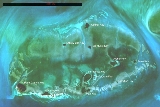
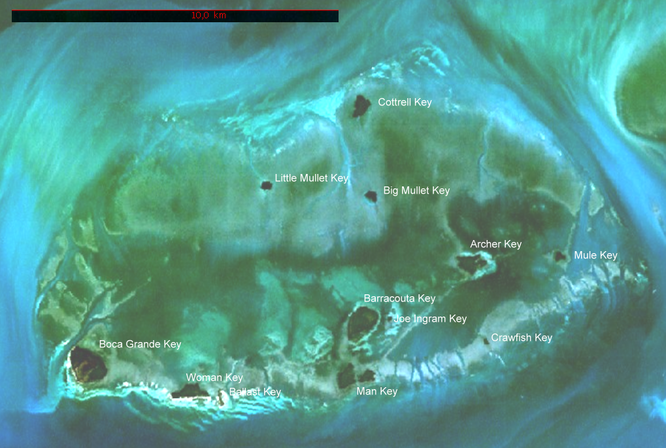
12 individual islets are named on detailed topographical maps:
On nautical maps, the Mule Keys appear like an atoll
of 11 miles (18 km) length east-west, and 6 miles (10 km) width north-south (covering a sea area of roughly 58 mi² (150 km²)), with Mule Key, Crawfish Key, Man Key, Ballast Key, Woman Key and Boca Grande Key along the southern rim (from east to west), and Cottrell Key in the north.
7 miles (11 km) south of Mule Key, separated from the Mule Keys by West Channel, are three notable submerged reefs, from east to west:
Florida Keys
The Florida Keys are a coral archipelago in southeast United States. They begin at the southeastern tip of the Florida peninsula, about south of Miami, and extend in a gentle arc south-southwest and then westward to Key West, the westernmost of the inhabited islands, and on to the uninhabited Dry...
in Monroe County
Monroe County, Florida
Monroe County is a county located in the state of Florida. As of 2000, the population was 79,589. The U.S. Census Bureau 2006 estimate for the county was 74,737....
, Florida
Florida
Florida is a state in the southeastern United States, located on the nation's Atlantic and Gulf coasts. It is bordered to the west by the Gulf of Mexico, to the north by Alabama and Georgia and to the east by the Atlantic Ocean. With a population of 18,801,310 as measured by the 2010 census, it...
, United States
United States
The United States of America is a federal constitutional republic comprising fifty states and a federal district...
. They are between 3 and 12 miles (5-20 km) west of Key West
Key West
Key West is an island in the Straits of Florida on the North American continent at the southernmost tip of the Florida Keys. Key West is home to the southernmost point in the Continental United States; the island is about from Cuba....
, separated from it by the Northwest Channel. On the west, they are separated from the Marquesas Keys
Marquesas Keys
The Marquesas Keys form an uninhabited island group about 30 miles west of Key West, 4 miles in diameter, and inhabited by mangrove. They are an unincorporated area of Monroe County, Florida and belong to the Lower Keys Census County Division. They are protected as part of the Key West National...
by 6 mile (10 km) wide Boca Grande Channel. They belong to the outlying islands of the Florida Keys. Administratively, they are unincorporated area
Unincorporated area
In law, an unincorporated area is a region of land that is not a part of any municipality.To "incorporate" in this context means to form a municipal corporation, a city, town, or village with its own government. An unincorporated community is usually not subject to or taxed by a municipal government...
of Monroe County. The islets all part of the Key West National Wildlife Refuge
Key West National Wildlife Refuge
The Key West National Wildlife Refuge is a 189,497 acre National Wildlife Refuge located in Monroe County, Florida, between Key West, Florida and the Dry Tortugas . Only 2,019 acres of land are above sea level, on several keys within the refuge. These keys are unpopulated and are also designated...
. The area of the islets totals 1.07 mi² (2.77 km²), of which 1.02 mi² (2.63 km²) are land area and 0.05 mi² (0.14 km²) inland water bodies (on three of the keys). The islets are uninhabited except Mule Key, for which the census
Census
A census is the procedure of systematically acquiring and recording information about the members of a given population. It is a regularly occurring and official count of a particular population. The term is used mostly in connection with national population and housing censuses; other common...
of 2000 lists one housing unit with a population of two (park rangers or coast guard).
The United States Government has placed most of this area off limits, as a part of the Key West National Wildlife Refuge
Key West National Wildlife Refuge
The Key West National Wildlife Refuge is a 189,497 acre National Wildlife Refuge located in Monroe County, Florida, between Key West, Florida and the Dry Tortugas . Only 2,019 acres of land are above sea level, on several keys within the refuge. These keys are unpopulated and are also designated...
. It is even prohibited to anchor off Man Key and Woman Key in the sand, although Woman Key was a popular destination for day trippers from Key West in the past, which Boca Grande Key still is. Anchoring off the south part of Boca Grande Key is also prohibited; it is permitted only off the northwest portion.
Ballast Key
Ballast Key
Ballast Key is an island in the Florida Keys in Monroe County, Florida, United States. It is the southernmost point of land in the contiguous United States. It is also the only privately owned land within the boundaries of the Key West National Wildlife Refuge.Located in the Outlying Islands of...
is privately owned and offered on the real estate market for US $
United States dollar
The United States dollar , also referred to as the American dollar, is the official currency of the United States of America. It is divided into 100 smaller units called cents or pennies....
13,800,000, as of July 2011.
The easternmost islet, Mule Key
Mule Key
Mule Key is an island in the Florida Keys in Monroe County, Florida, United States. It is within the boundaries of the Key West National Wildlife Refuge....
, is 2.7 miles (4.4 km) west of Sunset Key
Sunset Key
Sunset Key is a residential neighborhood and resort island in the City of Key West, Florida, United States. It is located about off the coast of the island of Key West. The island is privately held among its residents, one of which is the Key West Westin which operates a small number of guest...
which is part of Key West
Key West
Key West is an island in the Straits of Florida on the North American continent at the southernmost tip of the Florida Keys. Key West is home to the southernmost point in the Continental United States; the island is about from Cuba....
city. The westernmost (and largest) islet, Boca Grande Key
Boca Grande Key
Boca Grande Key is an island in the Florida Keys in Monroe County, Florida, United States. It is within the boundaries of the Key West National Wildlife Refuge....
, is 6 miles (10 km) east of the Marquesas Keys
Marquesas Keys
The Marquesas Keys form an uninhabited island group about 30 miles west of Key West, 4 miles in diameter, and inhabited by mangrove. They are an unincorporated area of Monroe County, Florida and belong to the Lower Keys Census County Division. They are protected as part of the Key West National...
.
12 individual islets are named on detailed topographical maps:
 |
||||||
| Block Census block A census block is the smallest geographic unit used by the United States Census Bureau for tabulation of 100-percent data . Several blocks make up block groups, which again make up census tracts. There are on average about 39 blocks per block group, but there are variations... Nr.1) |
Islet | LandArea(m²) | InlandWaters(m²) | TotalArea(m²) | Coordinates | Comment |
|---|---|---|---|---|---|---|
| 3031 | Mule Key Mule Key Mule Key is an island in the Florida Keys in Monroe County, Florida, United States. It is within the boundaries of the Key West National Wildlife Refuge.... |
52169 | - | 52169 | 24°33′43.2"N 81°51′42.4"W | easternmost |
| 3032 | Archer Key Archer Key Archer Key is an island in the Florida Keys in Monroe County, Florida, United States. It is within the boundaries of the Key West National Wildlife Refuge.... |
247136 | - | 247136 | 24°33′43.2"N 81°53′23.3"W | actually two separate islets |
| 3033 | Crawfish Key Crawfish Key Crawfish Key is an island in the Florida Keys in Monroe County, Florida, United States. It is within the boundaries of the Key West National Wildlife Refuge.... |
17125 | - | 17125 | 24°32′19.4"N 81°53′01.6"W | |
| 3034 | Barracouta Key Barracouta Key Barracouta Key is an island in the Florida Keys in Monroe County, Florida, United States. It is within the boundaries of the Key West National Wildlife Refuge.... 2) |
482627 | 57221 | 539848 | 24°32′38.5"N 81°55′17.5"W | including tiny islet 430 m south |
| Joe Ingram Key Joe Ingram Key Joe Ingram Key is an island in the Florida Keys in Monroe County, Florida, United States. It is within the boundaries of the Key West National Wildlife Refuge.... 2) |
- | 24°32′43.9"N 81°54′45.4"W | smallest | |||
| 3035 | Man Key Man Key Man Key is an island in the Florida Keys in Monroe County, Florida, United States. It is within the boundaries of the Key West National Wildlife Refuge.... |
358808 | - | 358808 | 24°31′40.3"N 81°55′38.5"W | actually three separate islets |
| 3036 | Ballast Key Ballast Key Ballast Key is an island in the Florida Keys in Monroe County, Florida, United States. It is the southernmost point of land in the contiguous United States. It is also the only privately owned land within the boundaries of the Key West National Wildlife Refuge.Located in the Outlying Islands of... |
46801 | 4741 | 51542 | 24°31′23.0"N 81°57′51.1"W | southernmost |
| 3037 | Woman Key Woman Key Woman Key is an island in the Florida Keys in Monroe County, Florida, United States. It is within the boundaries of the Key West National Wildlife Refuge.... |
317669 | - | 317669 | 24°31′27.6"N 81°58′25.4"W | |
| 3038 | Boca Grande Key Boca Grande Key Boca Grande Key is an island in the Florida Keys in Monroe County, Florida, United States. It is within the boundaries of the Key West National Wildlife Refuge.... |
741228 | 80416 | 821644 | 24°32′04.4"N 82°00′18.3"W | largest, westernmost |
| 3039 | Little Mullet Key Little Mullet Key Little Mullet Key is an island in the Florida Keys in Monroe County, Florida, United States. It is within the boundaries of the Key West National Wildlife Refuge.... |
58625 | - | 58625 | 24°34′53.8"N 81°57′01.9"W | |
| 3040 | Big Mullet Key Big Mullet Key Big Mullet Key is an island in the Florida Keys in Monroe County, Florida, United States. It is within the boundaries of the Key West National Wildlife Refuge.... |
87211 | - | 87211 | 24°34′44.5"N 81°55′08.0"W | |
| 3041 | Cottrell Key Cottrell Key Cottrell Key is an island in the Florida Keys in Monroe County, Florida, United States. It is within the boundaries of the Key West National Wildlife Refuge.... |
215943 | - | 215943 | 24°36′12.9"N 81°55′17.7"W | northernmost |
| Mule Keys | 2625342 | 142378 | 2767720 | |||
| 1) of Block Group Census block group A census block group is a geographical unit used by the United States Census Bureau which is between the census tract and the census block. It is the smallest geographical unit for which the bureau publishes sample data, i.e data which is only collected from a fraction of all households.Census... 3, Census tract Census tract A census tract, census area, or census district is a geographic region defined for the purpose of taking a census. Usually these coincide with the limits of cities, towns or other administrative areas and several tracts commonly exist within a county... 9725, Monroe County, Florida Monroe County, Florida Monroe County is a county located in the state of Florida. As of 2000, the population was 79,589. The U.S. Census Bureau 2006 estimate for the county was 74,737.... http://factfinder.census.gov/servlet/DTTable?_bm=y&-context=dt&-ds_name=DEC_2000_SF1_U&-CONTEXT=dt&-mt_name=DEC_2000_SF1_U_P001&-tree_id=4001&-transpose=N&-redoLog=true&-all_geo_types=N&-_caller=geoselect&-geo_id=100$10000US120879725003031&-geo_id=100$10000US120879725003032&-geo_id=100$10000US120879725003033&-geo_id=100$10000US120879725003034&-geo_id=100$10000US120879725003035&-geo_id=100$10000US120879725003036&-geo_id=100$10000US120879725003037&-geo_id=100$10000US120879725003038&-geo_id=100$10000US120879725003039&-geo_id=100$10000US120879725003040&-geo_id=100$10000US120879725003041&-search_results=15000US120879725003&-format=&-_lang=en&-show_geoid=Y] 2) Because Barracouta Key and Joe Ingram Key together form one census block, no exact separate area figures are available. Joe Ingram Key is estimated at 10,000 m². |
||||||
On nautical maps, the Mule Keys appear like an atoll
Atoll
An atoll is a coral island that encircles a lagoon partially or completely.- Usage :The word atoll comes from the Dhivehi word atholhu OED...
of 11 miles (18 km) length east-west, and 6 miles (10 km) width north-south (covering a sea area of roughly 58 mi² (150 km²)), with Mule Key, Crawfish Key, Man Key, Ballast Key, Woman Key and Boca Grande Key along the southern rim (from east to west), and Cottrell Key in the north.
7 miles (11 km) south of Mule Key, separated from the Mule Keys by West Channel, are three notable submerged reefs, from east to west:
- Eastern Dry Rocks, at 24°27′42.6"N 81°50′38.1"W
- Rock Key, at 24°27′21.3"N 81°51′26.3"W
- Sand KeySand Key LightSand Key Light is located six nautical miles southwest of Key West, Florida, between Sand Key Channel and Rock Key Channel, two of the channels into Key West. It is located on a reef that is intermittently covered by sand. At times the key has been substantial enough to have trees, and in 1900 nine...
, at 24°27′18.3"N 81°52′37.5"W
External links
- http://factfinder.census.gov/servlet/DTTable?_bm=y&-context=dt&-ds_name=DEC_2000_SF1_U&-CONTEXT=dt&-mt_name=DEC_2000_SF1_U_P001&-tree_id=4001&-transpose=N&-redoLog=true&-all_geo_types=N&-_caller=geoselect&-geo_id=100$10000US120879725003031&-geo_id=100$10000US120879725003032&-geo_id=100$10000US120879725003033&-geo_id=100$10000US120879725003034&-geo_id=100$10000US120879725003035&-geo_id=100$10000US120879725003036&-geo_id=100$10000US120879725003037&-geo_id=100$10000US120879725003038&-geo_id=100$10000US120879725003039&-geo_id=100$10000US120879725003040&-geo_id=100$10000US120879725003041&-search_results=15000US120879725003&-format=&-_lang=en&-show_geoid=YCensus 2000 block statistics]
- boating information
- Eastern Dry Rocks
- Rock Key
- Sand Key