

Mukeshpuri
Encyclopedia
Abbottabad District
Abbottabad is a district in the Khyber Pakhtunkhwa province of Pakistan. The district covers an area of 1,969 km with the city of Abbottabad being the principal town...
of the Khyber Pakhtunkhwa province in northern Pakistan
Pakistan
Pakistan , officially the Islamic Republic of Pakistan is a sovereign state in South Asia. It has a coastline along the Arabian Sea and the Gulf of Oman in the south and is bordered by Afghanistan and Iran in the west, India in the east and China in the far northeast. In the north, Tajikistan...
. It is 90 kilometres (55.9 mi) north of Islamabad
Islamabad
Islamabad is the capital of Pakistan and the tenth largest city in the country. Located within the Islamabad Capital Territory , the population of the city has grown from 100,000 in 1951 to 1.7 million in 2011...
, just above Dunga Gali
Dunga Gali
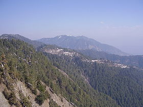
Dunga Gali or Doonga Gali is one of the tourist mountain resort towns of the Galyat area of Ayubia National Park, at an altitude of in northern Pakistan Dunga Gali is located in Nathia Gali Union Council of Abbottabad District in the Khyber Pakhtunkhwa Province.During British rule Dunga Gali...
in the Nathiagali area of Ayubia National Park
Ayubia National Park
Ayubia National Park is a protected area of located in Abbottabad District, Khyber Pakhtunkhwa province, northern Pakistan. It was declared a national park in 1984. Ayubia was named after the late Muhammad Ayub Khan , second President of Pakistan...
. Much of it the mountain is covered with Western Himalayan subalpine conifer forests
Western Himalayan subalpine conifer forests
The Western Himalayan subalpine conifer forests is a temperate coniferous forests ecoregion of the middle and upper elevations of the western Middle Himalayas of Nepal, India, and Pakistan.-Setting:...
.
Etymology
The name Mukeshpuri is derived from the SanskritSanskrit
Sanskrit , is a historical Indo-Aryan language and the primary liturgical language of Hinduism, Jainism and Buddhism.Buddhism: besides Pali, see Buddhist Hybrid Sanskrit Today, it is listed as one of the 22 scheduled languages of India and is an official language of the state of Uttarakhand...
words: Moksha (liberation) and Puri (city). Mukeshpuri has a special of significance for the Hindu
Hindu
Hindu refers to an identity associated with the philosophical, religious and cultural systems that are indigenous to the Indian subcontinent. As used in the Constitution of India, the word "Hindu" is also attributed to all persons professing any Indian religion...
s because of the Legends relating it to the Pandavas of the Mahabharata
Mahabharata
The Mahabharata is one of the two major Sanskrit epics of ancient India and Nepal, the other being the Ramayana. The epic is part of itihasa....
.
There are the five Pandava
Pandava
In the Hindu epic Mahābhārata, the Pandava are the five acknowledged sons of Pandu , by his two wives Kunti and Madri. Their names are Yudhisthira, Bhima, Arjuna, Nakula and Sahadeva. Although, Karna is told by Lord Krishna that according to the laws and ethics he is the first son of Kunti making...
s, the heroes of the Mahabharata
Mahabharata
The Mahabharata is one of the two major Sanskrit epics of ancient India and Nepal, the other being the Ramayana. The epic is part of itihasa....
, who are favourite objects of worship in the east and sometimes addressed as the Panj Pir (five saints). Many are the legends current about these heroes and they are localised at quite a number of places. The Hill of Mokshpuri's name means 'the hill of salvation' and on its summit is a Panduan da Sthan, or place of the Pandavas.
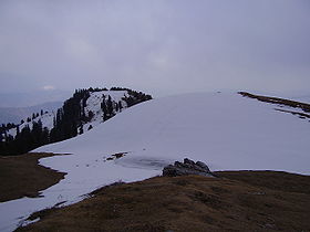
The Peak
The route from Nathiagali on western side of mountain is a steady and 4 kilometres (2.5 mi) long climb. The mountain also has a route on the Dunga GaliDunga Gali
Dunga Gali or Doonga Gali is one of the tourist mountain resort towns of the Galyat area of Ayubia National Park, at an altitude of in northern Pakistan Dunga Gali is located in Nathia Gali Union Council of Abbottabad District in the Khyber Pakhtunkhwa Province.During British rule Dunga Gali...
side, with a steeper slop. There is a bird sanctuary on this side created with the help of the European Union
European Union
The European Union is an economic and political union of 27 independent member states which are located primarily in Europe. The EU traces its origins from the European Coal and Steel Community and the European Economic Community , formed by six countries in 1958...
.
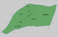
From the top of Mukeshpuri peak, on the eastern edge of Khyber Pakhtunkhwa, the following areas can be seen: — Circle Bakote, Jhelum River
Jhelum River
Jehlum River or Jhelum River , ) is a river that flows in India and Pakistan. It is the largest and most western of the five rivers of Punjab, and passes through Jhelum District...
, the Bagh District
Bagh District
Bagh District is one of the eight districts of Azad Jammu and Kashmir, Pakistan. The district, which had been part of Poonch District, was created in 1988...
of Azad Kashmir
Azad Kashmir
Azad Jammu and Kashmir or Azad Kashmir for short, is the southernmost political entity within the Pakistani-administered part of the former princely state of Jammu and Kashmir...
, in the south the city of Murree
Murree
Murree city is a popular hill station and a summer resort, especially for the residents of Rawalpindi/Islamabad, and for the cities of the province of Punjab, Pakistan...
and the Murree Tehsil
Murree Tehsil
Murree Tehsil is one of the seven Tehsils of Rawalpindi District in the Punjab province of Pakistan.Murree Tehsil is located in the northernmost part of Punjab province where it borders the North West Frontier Province...
, as well as Islamabad.
See also
- List of mountains in Pakistan
- Galyat regionGalyatGalyat region is an area roughly 50–80 km north-east of Islamabad, Pakistan, on both sides of the Khyber Pakhtunkhwa-Punjab border.The word Galyat is the plural of the Urdu word gali, which means an alley between two mountains on both sides of which there are valleys and it is not the highest...
- the local region and its towns - Muree - adjacent in the Rawalpindi District