

Mount Takahe
Encyclopedia
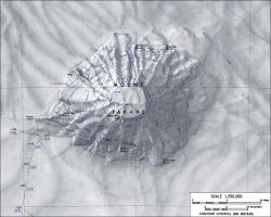
Mount Takahe is a large, snow covered shield volcano
standing 64 km SE of Toney Mountain
in Marie Byrd Land
, Antarctica. It is roughly circular, about 29 km across, and has a caldera
up to 8 km wide. At 780 cubic km, it is a massive volcano. The volcano may have last erupted during the Holocene
, and thus it is probably a potentially active volcano.
Takahe was probably among those viewed from a distance by Admiral Byrd and other members of the USAS in plane flights from the ship Bear on Feb. 24 and 25, 1940. It was visited in December 1957 by members of the Marie Byrd Land Traverse Party, 1957–58, who applied the name. "Takahe," the Māori name for a flightless, almost extinct New Zealand
bird, is the nickname of the U.S. Navy LC-47 aircraft whose crew resupplied the traverse party near this mountain and assisted by providing aerial reconnaissance to locate passable routes.
on the northwest side of Mount Takahe, in Marie Byrd Land
. Mapped by United States Geological Survey
(USGS) from ground surveys and U.S. Navy air photos, 1959-66. Named by Advisory Committee on Antarctic Names
(US-ACAN) for Allan Gill, aurora
researcher at Byrd Station
in 1963.
Shield volcano
A shield volcano is a type of volcano usually built almost entirely of fluid lava flows. They are named for their large size and low profile, resembling a warrior's shield. This is caused by the highly fluid lava they erupt, which travels farther than lava erupted from more explosive volcanoes...
standing 64 km SE of Toney Mountain
Toney Mountain
Toney Mountain is an elongated snow-covered shield volcano, 60 km long and rising to 3,595 m in Richmond Peak, located 56 km SW of Kohler Range in Marie Byrd Land...
in Marie Byrd Land
Marie Byrd Land
Marie Byrd Land is the portion of West Antarctica lying east of the Ross Ice Shelf and the Ross Sea and south of the Pacific Ocean, extending eastward approximately to a line between the head of the Ross Ice Shelf and Eights Coast. It stretches between 158°W and 103°24'W...
, Antarctica. It is roughly circular, about 29 km across, and has a caldera
Caldera
A caldera is a cauldron-like volcanic feature usually formed by the collapse of land following a volcanic eruption, such as the one at Yellowstone National Park in the US. They are sometimes confused with volcanic craters...
up to 8 km wide. At 780 cubic km, it is a massive volcano. The volcano may have last erupted during the Holocene
Holocene
The Holocene is a geological epoch which began at the end of the Pleistocene and continues to the present. The Holocene is part of the Quaternary period. Its name comes from the Greek words and , meaning "entirely recent"...
, and thus it is probably a potentially active volcano.
Takahe was probably among those viewed from a distance by Admiral Byrd and other members of the USAS in plane flights from the ship Bear on Feb. 24 and 25, 1940. It was visited in December 1957 by members of the Marie Byrd Land Traverse Party, 1957–58, who applied the name. "Takahe," the Māori name for a flightless, almost extinct New Zealand
New Zealand
New Zealand is an island country in the south-western Pacific Ocean comprising two main landmasses and numerous smaller islands. The country is situated some east of Australia across the Tasman Sea, and roughly south of the Pacific island nations of New Caledonia, Fiji, and Tonga...
bird, is the nickname of the U.S. Navy LC-47 aircraft whose crew resupplied the traverse party near this mountain and assisted by providing aerial reconnaissance to locate passable routes.
Gill Bluff
Gill Bluff (76°14′S 112°33′W) is a rock bluffCliff
In geography and geology, a cliff is a significant vertical, or near vertical, rock exposure. Cliffs are formed as erosion landforms due to the processes of erosion and weathering that produce them. Cliffs are common on coasts, in mountainous areas, escarpments and along rivers. Cliffs are usually...
on the northwest side of Mount Takahe, in Marie Byrd Land
Marie Byrd Land
Marie Byrd Land is the portion of West Antarctica lying east of the Ross Ice Shelf and the Ross Sea and south of the Pacific Ocean, extending eastward approximately to a line between the head of the Ross Ice Shelf and Eights Coast. It stretches between 158°W and 103°24'W...
. Mapped by United States Geological Survey
United States Geological Survey
The United States Geological Survey is a scientific agency of the United States government. The scientists of the USGS study the landscape of the United States, its natural resources, and the natural hazards that threaten it. The organization has four major science disciplines, concerning biology,...
(USGS) from ground surveys and U.S. Navy air photos, 1959-66. Named by Advisory Committee on Antarctic Names
Advisory Committee on Antarctic Names
The Advisory Committee on Antarctic Names is an advisory committee of the United States Board on Geographic Names responsible for recommending names for features in Antarctica...
(US-ACAN) for Allan Gill, aurora
Aurora (astronomy)
An aurora is a natural light display in the sky particularly in the high latitude regions, caused by the collision of energetic charged particles with atoms in the high altitude atmosphere...
researcher at Byrd Station
Byrd Station
Byrd Station refers to a research station established by the United States during the International Geophysical Year by the U.S. Navy during Operation Deep Freeze II in West Antarctica at 80°, 120°W...
in 1963.