
Mount Pavlof
Encyclopedia
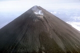
Pavlof Volcano is a stratovolcano
of the Aleutian Range
on the Alaska Peninsula
. It has been one of the most active in the United States
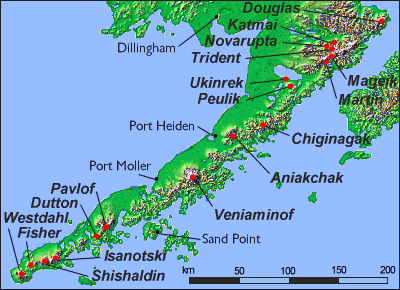
since 1980, with eruptions recorded in 1980, 1981, 1983, 1986–1988, 1996–1997, and an ongoing eruption starting on August 15, 2007 and ending on September 13. The Alaska Volcano Observatory
currently rates Pavlof as Aviation Color Code Green and Volcano Alert Level Normal. With a threat score of 95, the threat from future eruptions is considered to be high; much of this threat comes from the possibility of disruption of nearby air routes by large releases of ash. The mountain currently has basic real-time monitoring, but the USGS
would like to improve instrumentation at the site. The mountain shares a name with the nearby Pavlof Sister
, which last erupted in 1786.
The first recorded ascent of Pavlof Volcano was on June 27, 1928 by T. A. Jagger, J. Gardiner, O. P. McKinley, P. A. Yatchmenoff, R. H. Stewart, although "speculation surrounds this ascent, which was recounted in National Geographic." Due to the straightforward nature of the climb, an earlier unrecorded ascent may have occurred. The second ascent was in June 1950 by T. P. Bank.
The main challenge of climbing this peak is its remoteness and the consequent difficulty of access. The peak is a 30 mi (48 km) journey from the north side of Cold Bay. The climb itself is a straightforward snow climb, and the ski descent is recommended.
Since its last eruption in 1996, the volcano entered a period of dormancy, the longest it has ever been dormant since records of its eruptions have been kept. This period ended on August 15, 2007, with the start of a new eruption involving seismic disturbances and a "vigorous eruption of lava." Scientists said that the volcano "could be working toward a massive eruption that could affect air travel but was not expected to threaten any of the towns in the area." The eruption ended on September 13, but activity may resume soon.
Stratovolcano
A stratovolcano, also known as a composite volcano, is a tall, conical volcano built up by many layers of hardened lava, tephra, pumice, and volcanic ash. Unlike shield volcanoes, stratovolcanoes are characterized by a steep profile and periodic, explosive eruptions...
of the Aleutian Range
Aleutian Range
The Aleutian Range is a major mountain range of southwest Alaska, extending from Chakachamna Lake to Unimak Island, at the tip of the Alaska Peninsula. It includes all of the mountains of the Peninsula. It is especially notable for its large number of active volcanoes, which are also part of the...
on the Alaska Peninsula
Alaska Peninsula
The Alaska Peninsula is a peninsula extending about to the southwest from the mainland of Alaska and ending in the Aleutian Islands. The peninsula separates the Pacific Ocean from Bristol Bay, an arm of the Bering Sea....
. It has been one of the most active in the United States
United States
The United States of America is a federal constitutional republic comprising fifty states and a federal district...
since 1980, with eruptions recorded in 1980, 1981, 1983, 1986–1988, 1996–1997, and an ongoing eruption starting on August 15, 2007 and ending on September 13. The Alaska Volcano Observatory
Alaska Volcano Observatory
The Alaska Volcano Observatory is a joint program of the United States Geological Survey, the Geophysical Institute of the University of Alaska Fairbanks, and the State of Alaska Division of Geological and Geophysical Surveys...
currently rates Pavlof as Aviation Color Code Green and Volcano Alert Level Normal. With a threat score of 95, the threat from future eruptions is considered to be high; much of this threat comes from the possibility of disruption of nearby air routes by large releases of ash. The mountain currently has basic real-time monitoring, but the USGS
United States Geological Survey
The United States Geological Survey is a scientific agency of the United States government. The scientists of the USGS study the landscape of the United States, its natural resources, and the natural hazards that threaten it. The organization has four major science disciplines, concerning biology,...
would like to improve instrumentation at the site. The mountain shares a name with the nearby Pavlof Sister
Pavlof Sister
Pavlov Sister is a stratovolcano on the Alaska Peninsula. It is a satellite peak of Mount Pavlof, lying directly northeast. The mountain was named by the USGS in 1929.-Sources:* *...
, which last erupted in 1786.
The first recorded ascent of Pavlof Volcano was on June 27, 1928 by T. A. Jagger, J. Gardiner, O. P. McKinley, P. A. Yatchmenoff, R. H. Stewart, although "speculation surrounds this ascent, which was recounted in National Geographic." Due to the straightforward nature of the climb, an earlier unrecorded ascent may have occurred. The second ascent was in June 1950 by T. P. Bank.
The main challenge of climbing this peak is its remoteness and the consequent difficulty of access. The peak is a 30 mi (48 km) journey from the north side of Cold Bay. The climb itself is a straightforward snow climb, and the ski descent is recommended.
Since its last eruption in 1996, the volcano entered a period of dormancy, the longest it has ever been dormant since records of its eruptions have been kept. This period ended on August 15, 2007, with the start of a new eruption involving seismic disturbances and a "vigorous eruption of lava." Scientists said that the volcano "could be working toward a massive eruption that could affect air travel but was not expected to threaten any of the towns in the area." The eruption ended on September 13, but activity may resume soon.
See also
- Mountain peaks of AlaskaMountain peaks of AlaskaThis article comprises three sortable tables of mountain peaks of the U.S. State of Alaska.Topographic elevation is the vertical distance above the reference geoid, a precise mathematical model of the Earth's sea level as an equipotential gravitational surface. Topographic prominence is the...
- Mountain peaks of North AmericaMountain peaks of North AmericaThis article comprises three sortable tables of major mountain peaks of greater North America.This article defines greater North America as the portion of the continental landmass of the Americas extending northward from Panama plus the islands surrounding that landmass...
- Mountain peaks of the United StatesMountain peaks of the United StatesThis article comprises three sortable tables of the major mountain peaks of the United States of America.Topographic elevation is the vertical distance above the reference geoid, a precise mathematical model of the Earth's sea level as an equipotential gravitational surface...