

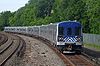
Morris Heights (Metro-North station)
Encyclopedia
The Morris Heights Metro-North
station
serves the residents of the Morris Heights
neighborhood of the Bronx, New York via the Hudson Line
. Trains leave for New York City
every 25 to 35 minutes during peak hours, and every hour at other times and on weekends. It is 8.1 miles (13 km) from Grand Central Terminal
and travel time to Grand Central is approximately 17 minutes. Morris Heights is the second-southernmost station before the Hudson Line joins with the Harlem Line and New Haven Line.
It is located in the narrow strip of land between the Major Deegan Expressway
and the Harlem River
, next to Roberto Clemente State Park
.
The station has operated since the days of the New York and Putnam Railroad early in the 20th century, though not in its present form.
serving northbound and southbound trains and accessible from West Tremont Avenue (West 177th Street). The platform is four cars long; when trains stop at this station, only four cars can receive and discharge passengers.
The platform is adjacent to Tracks 1 and 2. Track 4, to the west and not adjacent to the platform, is used only by express trains.
Metro-North Railroad
The Metro-North Commuter Railroad , trading as MTA Metro-North Railroad, or, more commonly, Metro-North, is a suburban commuter rail service that is run and managed by the Metropolitan Transportation Authority , an authority of New York State. It is the busiest commuter railroad in the United...
station
Train station
A train station, also called a railroad station or railway station and often shortened to just station,"Station" is commonly understood to mean "train station" unless otherwise qualified. This is evident from dictionary entries e.g...
serves the residents of the Morris Heights
Morris Heights, Bronx
Morris Heights is a low income residential neighborhood located in the west Bronx. The neighborhood is part of Bronx Community Board 5. Its boundaries, starting from the north and moving clockwise are: West Burnside Avenue to the north, Jerome Avenue to the east, the Cross-Bronx Expressway to the...
neighborhood of the Bronx, New York via the Hudson Line
Hudson Line (Metro-North)
Metro-North Railroad's Hudson Line is a commuter rail line running north from New York City along the east shore of the Hudson River. Metro-North service ends at Poughkeepsie, with Amtrak's Empire Corridor trains continuing north to and beyond Albany...
. Trains leave for New York City
New York City
New York is the most populous city in the United States and the center of the New York Metropolitan Area, one of the most populous metropolitan areas in the world. New York exerts a significant impact upon global commerce, finance, media, art, fashion, research, technology, education, and...
every 25 to 35 minutes during peak hours, and every hour at other times and on weekends. It is 8.1 miles (13 km) from Grand Central Terminal
Grand Central Terminal
Grand Central Terminal —often incorrectly called Grand Central Station, or shortened to simply Grand Central—is a terminal station at 42nd Street and Park Avenue in Midtown Manhattan in New York City, United States...
and travel time to Grand Central is approximately 17 minutes. Morris Heights is the second-southernmost station before the Hudson Line joins with the Harlem Line and New Haven Line.
It is located in the narrow strip of land between the Major Deegan Expressway
Major Deegan Expressway
The Major Deegan Expressway is a north–south expressway in the New York City borough of the Bronx...
and the Harlem River
Harlem River
The Harlem River is a navigable tidal strait in New York City, USA that flows 8 miles between the Hudson River and the East River, separating the boroughs of Manhattan and the Bronx...
, next to Roberto Clemente State Park
Roberto Clemente State Park
Roberto Clemente State Park is a state park in the South Bronx, New York in the USA. The park is in the northern part of New York City, adjacent to the Harlem River, the Major Deegan Expressway and the Morris Heights station on Metro-North's Hudson Line...
.
The station has operated since the days of the New York and Putnam Railroad early in the 20th century, though not in its present form.
Platform and track configuration
This station has one high-level island platformIsland platform
An island platform is a station layout arrangement where a single platform is positioned between two tracks within a railway station, tram stop or transitway interchange...
serving northbound and southbound trains and accessible from West Tremont Avenue (West 177th Street). The platform is four cars long; when trains stop at this station, only four cars can receive and discharge passengers.
The platform is adjacent to Tracks 1 and 2. Track 4, to the west and not adjacent to the platform, is used only by express trains.
External links
- Metro-North Railroad - Morris Heights
- List of upcoming train departure times and track assignments from MTA
- Station from Major Deegan Expressway from Google Maps Street View