
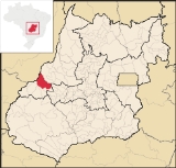
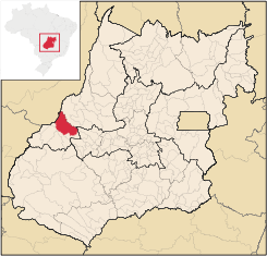
Montes Claros de Goiás
Encyclopedia
| Montes Claros de Goiás | |
|---|---|
| State | Goiás Goiás Goiás is a state of Brazil, located in the central part of the country. The name Goiás comes from the name of an indigenous community... |
| Area: | 2,899 km² (10/10/2002) |
| Population: | 7,844 (IBGE 2007) |
| Elevation: | 472m above sea level |
| Postcode (CEP): | 76255-000 |
| Became a city: | 1963 |
| Distance to Goiânia Goiânia -Climate:The city has a tropical wet and dry climate with an average temperature of . There's a wet season, from October to April, and a dry one, from May to September. Annual rainfall is around 1,520 mm.... : |
277 km. |
| IBGE statistical microregion: | Aragarças Microregion Aragarças Microregion The Aragarças Microregion is a geographical division in Goiás state, Brazil. It consists of 7 municipalities located near Aragarças in western Goiás. For a map see -Important Data :*Population: 53,541*Cities: 7*Total Area: 11,091.90 km²... |
| Website: | n/a |
| Coordinates: | 16°00′42"S 51°23′13"W |
Town
A town is a human settlement larger than a village but smaller than a city. The size a settlement must be in order to be called a "town" varies considerably in different parts of the world, so that, for example, many American "small towns" seem to British people to be no more than villages, while...
and municipality
Municipality
A municipality is essentially an urban administrative division having corporate status and usually powers of self-government. It can also be used to mean the governing body of a municipality. A municipality is a general-purpose administrative subdivision, as opposed to a special-purpose district...
in western Goiás
Goiás
Goiás is a state of Brazil, located in the central part of the country. The name Goiás comes from the name of an indigenous community...
state, Brazil
Brazil
Brazil , officially the Federative Republic of Brazil , is the largest country in South America. It is the world's fifth largest country, both by geographical area and by population with over 192 million people...
Location and connections
Montes Claros is located in the extreme west of the state, about 70 km east of the Araguaia RiverAraguaia River
The Araguaia River or, in Portuguese, Rio Araguaia is one of the major rivers of Brazil, and the principal tributary of the Tocantins. It has a total length of approximately 2,627 km. Araguaia means "river of macaws" in the Tupi language....
. It is east of Aragarças
Aragarças
Aragarças is a small town and municipality in southwest Goiás state, Brazil.-Location:Aragarças is the most important town in the Aragarças Microregion. It is 410 km...
and west of Jussara
Jussara
Jussara is a small town and municipality in Goiás state, Brazil. Jussara is a major producer of cattle for the beef market.-Location and history:Jussara is located in the region of the Vale do Araguaia, 222 kilometers from the state capital of Goiânia...
.
Montes Claros is connected by poor roads to Aragarças
Aragarças
Aragarças is a small town and municipality in southwest Goiás state, Brazil.-Location:Aragarças is the most important town in the Aragarças Microregion. It is 410 km...
, 117 km to the west; and Jussara
Jussara
Jussara is a small town and municipality in Goiás state, Brazil. Jussara is a major producer of cattle for the beef market.-Location and history:Jussara is located in the region of the Vale do Araguaia, 222 kilometers from the state capital of Goiânia...
, 56 km to the west. It is bathed by the Rio Claro, the Araguaia River
Araguaia River
The Araguaia River or, in Portuguese, Rio Araguaia is one of the major rivers of Brazil, and the principal tributary of the Tocantins. It has a total length of approximately 2,627 km. Araguaia means "river of macaws" in the Tupi language....
, the Caiapó, the Rio das Almas or Rio dos Bois.
Neighboring municipalities are: Aragarças
Aragarças
Aragarças is a small town and municipality in southwest Goiás state, Brazil.-Location:Aragarças is the most important town in the Aragarças Microregion. It is 410 km...
, Arenópolis
Arenópolis
Arenópolis is a small town and municipality in eastern Goiás state, Brazil. The population was 3,495 in a total area of 1,074.5 km².-Location and Connections with Goiânia:...
, Bom Jardim de Goiás
Bom Jardim de Goiás
Bom Jardim de Goiás is a small town and municipality in western Goiás state, Brazil. The population was 8,372 in a total area of 1,557 km². Bom Jardim is a large producer of cattle.-Location:...
, Diorama
Diorama, Goiás
Diorama is a small town and municipality in eastern Goiás state, Brazil.-Location and Connections:Diorama is 254 kilometers west of the state capital, Goiânia, and is 30 kilometers west of the regional center, Iporá...
, Fazenda Nova
Fazenda Nova
Fazenda Nova is a small town and municipality in central-west Goiás state, Brazil.-Location:Fazenda Nova is located northwest of the state capital, Goiânia, which is 206 km. away taking highways GO-418 and GO-060...
, Jaupaci
Jaupaci
Jaupaci is a small town and municipality in eastern Goiás state, Brazil. The population was 2,998 in a total area of 527.2 km² .-Location:*Distance to regional center : 46 km....
, Jussara
Jussara
Jussara is a small town and municipality in Goiás state, Brazil. Jussara is a major producer of cattle for the beef market.-Location and history:Jussara is located in the region of the Vale do Araguaia, 222 kilometers from the state capital of Goiânia...
and the state of Mato Grosso
Mato Grosso
Mato Grosso is one of the states of Brazil, the third largest in area, located in the western part of the country.Neighboring states are Rondônia, Amazonas, Pará, Tocantins, Goiás and Mato Grosso do Sul. It also borders Bolivia to the southwest...
.
Political information
In January 2005 the Mayor was Manoel Carlos da Silva Filho and the Vice-mayor was Antônio Cícero Alves. There were 9 council-members on the city council and the number of eligible voters was 5,834 in 2007.Demographic information
In 2007 the population density was 2.71 inhab/km². The population has decreased by almost 1,500 inhabitants since 1980. Between 1996 and 2007 it decreased -0.142.%. In 2007 the number of urban inhabitants (4,856) surpassed the number of rural inhabitants (2,988).Economic information
The main economic activity is cattle raising with 255,000 head of beef cattle and 16,500 head of dairy cattle in 2006. Most of the population worked in services, public administration, modest transformation industries, and agriculture. In 2007 there were 9 industrial units and 131 retail units. The sector employing more workers was commerce. In 2007 there were two financial institutions: Banco do Brasil S.A. and BRADESCO S.A. There were 429 automobiles in 2007.In 2005 the main agricultural products by area were rice, beans, corn, and soybeans. Soybean production has increased substantially in recent years and there were 7,200 ha. planted in 2006 with a production of 21,000 tons.
Agricultural data 2006
- Number of farms: 687
- Total area: 220,739 ha.
- Area of permanent crops: 276 ha. (bananas)
- Area of perennial crops: 35,811 ha. (soybeans, corn, rice)
- Area of natural pasture: 120,671 ha.
- Area of woodland and forests: 52,005 ha.
- Cattle herd: 255,000
- Number of agricultural workers: 1,900
- Number of farms with tractors: 144
- Number of tractors: 259 IBGE
Health and education
In 2007 there was 1 hospital with 14 beds and 1 walk-in health clinic. The infant mortality rate was 18.31 for every 1,000 live births in 2000.In 2006 the school system had 16 schools, 78 classrooms, 146 teachers and 2,357 students. There were no institutions of higher learning. The adult literacy rate was 84.5% in 2000.
- Municipal Human Development IndexHuman Development IndexThe Human Development Index is a composite statistic used to rank countries by level of "human development" and separate "very high human development", "high human development", "medium human development", and "low human development" countries...
: 0.750 - Ranking with municipalities in Goiás: 78 out of 242 in 2000
- National ranking: 1,894 out of 5,507 in 2000
History
Settlement began in 1956 on the Fazenda Salobinha owned by Enemias Lino de Oliveira. The owner donated the land, which was divided into lots and sold at low prices to new settlers. The first name was "Salobinha". In 1958 it became a district of the municipality of GoiásGoiás, Goiás
Goiás is a small city and municipality in the state of Goiás in Brazil. The population was 24,072 in a total area of 3,108 km² . It is the former capital of the state and preserves much of its colonial heritage...
, passing to the new municipality of Diorama
Diorama, Goiás
Diorama is a small town and municipality in eastern Goiás state, Brazil.-Location and Connections:Diorama is 254 kilometers west of the state capital, Goiânia, and is 30 kilometers west of the regional center, Iporá...
in the same year. In 1963 it became an independent municipality with the new name of Montes Claros de Goiás, taken from the existence of small hills nearby and the Rio Claro, which lies 15 kilometers from the municipal seat.