

Monte Carmelo
Encyclopedia
Minas Gerais
Minas Gerais is one of the 26 states of Brazil, of which it is the second most populous, the third richest, and the fourth largest in area. Minas Gerais is the Brazilian state with the largest number of Presidents of Brazil, the current one, Dilma Rousseff, being one of them. The capital is the...
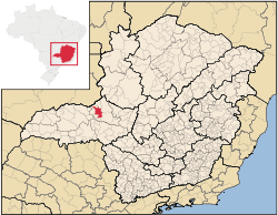
. Its population as of 2007 was 44,367 people living in a total area of 1,354 km². The city belongs to the mesoregion
Mesoregion (Brazil)
Mesoregions are subdivisions of Brazilian states, grouping together various municipalities in proximity and with common characteristics. They were created by the Brazilian Institute of Geography and Statistics for statistical purposes and do not, therefore, constitute an administrative area....
of Triângulo Mineiro
Triângulo Mineiro
The Triangle Mineiro Portuguese pronunciation: [tɾiɐɡulu minejru] is an officer in the region west of the state of Minas Gerais, Brazil. The area is 93.500 km ² and is limited by the Serra da Canastra and Marcela, east, south of Sao Paulo, Goias in the north and west of the junction of the rivers...
e Alto Paranaíba and to the microregion
Microregion (Brazil)
Microregions are legally defined administrative areas in Brazil consisting of groups of municipalities bordering urban areas. Microregions are grouped together into mesoregions....
of Patrocínio
Patrocínio
Patrocínio is a municipality in the state of Minas Gerais in Brazil. The population of the municipality in 2007 was 81,589. The area is 2,867 km² and the elevation is 965 mts.-Highway connections:...
. It became a municipality in 1840.
Location
The municipality is located in the region of the Alto Paranaíba, south of the Paranaíba River and west of the Emborcação Reservoir. It is 33 km north of the important federal highway Br-365, which links the state boundary of GoiásGoiás
Goiás is a state of Brazil, located in the central part of the country. The name Goiás comes from the name of an indigenous community...
in the west to Montes Claros
Montes Claros
Montes Claros is a city located in northern Minas Gerais state, in Brazil. The estimated population in 2010 was 412,284 inhabitants and the total area of the municipality was 3,470 km²...
in the northeast. Neighboring municipalities are: Catalão
Catalão
Catalão is a small city and municipality located in the south of the state of Goiás, in Brazil. It is a large producer of grains, cattle, and phosphates and has a John Deere and Mitsubishi factory.-Demographics:*Population density: 17.85 inhab/km²...
(N), Monte Carmelo (E), Coromandel
Coromandel, Minas Gerais
Coromandel is a Brazilian town, located in the southeast region of the country, in the state of Minas Gerais. Its population is over 28,000 people according the 2004 census. The municipality of Coromandel is located 495 km from the state capital Belo Horizonte, and 673 km from São Paulo...
(S), and Douradoquara
Douradoquara
Doradoquara is a Brazilian municipality located in the northwest of the state of Minas Gerais. Its population as of 2007 was 1,846 people living in a total area of 313 km². The city belongs to the mesoregion of Triângulo Mineiro e Alto Paranaíba and to the microregion of Patrocínio...
(W).
Geography
The municipal seat is located at an elevation of 864 meters. The highest point in the municipality is Cabeceira Córrego Rancharia at 1,343 meters, while the lowest point is Foz Córrego Francos at 724 meters.Climate
- Yearly average: 20.7 °C
- Yearly average maximum: 27.9 °C
- Yearly average minimum: 14.8 °C
- Yearly average rainfall index: 1569.1 mm
Distances
- Abadia dos DouradosAbadia dos DouradosAbadia dos Dourados is a Brazilian municipality located in the northwest of the state of Minas Gerais. Its population as of 2007 was 6,556 people living in a total area of 894 km². The city belongs to the mesoregion of Triângulo Mineiro e Alto Paranaíba and to the microregion of Patrocínio...
: 20 km - BR-365: 31 km
- PatrocínioPatrocínioPatrocínio is a municipality in the state of Minas Gerais in Brazil. The population of the municipality in 2007 was 81,589. The area is 2,867 km² and the elevation is 965 mts.-Highway connections:...
: 64 km - UberlândiaUberlândiaUberlândia is the main town in the Triangle region, west of the state of Minas Gerais, Brazil. With a population of 604,013 inhabitants, according to 2010 estimates, the city is the second largest in the state second only to Belo Horizonte...
: 100 km - Belo HorizonteBelo HorizonteBelo Horizonte is the capital of and largest city in the state of Minas Gerais, located in the southeastern region of Brazil. It is the third largest metropolitan area in the country...
: 515 km - BrasíliaBrasíliaBrasília is the capital city of Brazil. The name is commonly spelled Brasilia in English. The city and its District are located in the Central-West region of the country, along a plateau known as Planalto Central. It has a population of about 2,557,000 as of the 2008 IBGE estimate, making it the...
: 465 km
History
The first European settlers came in 1840 in search of diamonds. A rich landowner, Dona Clara Chaves, donated land measuring six square leagues to the new settlers to build a chapel dedicated to Our Lady of Carmo. The first settlement was called Arraial do Carmo da Bagagem”.In 1882, it was elevated to the category of district and was called “Nossa Senhora do Carmo da Bagagem”. In 1892 it became a vila (city) and in 1900 the name was changed to Monte Carmelo, after the mountain near Haifa.
Economic activities
The most important economic activities are cattle raising, commerce, and agriculture. The GDP in 2005 was R$ R$400 million, with 230 million generated by services, 36 million generated by industry, and 95 million generated by agriculture. Monte Carmelo is in the top tier of municipalities in the state with regard to economic and social development. As of 2007 there were 05 banking agencies in the town. There was a well-developed retail infrastructure serving the surrounding area of cattle and agricultural lands. There were 8,603 automobiles in all of the municipality (2007), about one for every 05 inhabitants.There are three dairy industries with production of cheese and liquid yogurt. There are 07 industries producting spices. There are two coffee processing industries. Other industries produce furniture, textiles, chemical products, and soap. Monte Carmelo is considered the capital of the roof tile due to the number of ceramic industries. Tiles are shipped to all the regions of the country. There are also traditional handicraft workshops producing clay pots and water filters.
Monte Carmelo has a large portion of its economy based on agriculture and livestock raising. In the rural area there were 1,391 establishments (2006) occupying 115,000 hectares (planted area—31,800 ha, and natural pasture—60,000 ha.). About 9,000 persons were dependent on agriculture with 6,500 workers hired by farms. 400 of the farms had tractors, a ratio of one in 03 farms. There were 53,000 head of cattle in 2006, half of which were milk cows. There is a well-developed poultry raising sector producing two million chickens a year and one million seven hundred thousand turkeys a year.
The main crops were:
- coffee: 12,000 hectares with 45 million trees
- avocado:200 hectares
- rubber:70 hectares
- passion fruit:200 hectares
- rice: 280 hectares
- beans: 1,200 hectares
- corn: 7,000 hectares
- soybeans: 7,000 hectares
- sorghum: 200 hectares
Health and education
In the health sector there were 21 health clinics and 04 hospitals with 116 beds. In the educational sector there were 22 pre-primary schools, 21 primary schools, and 04 middle schools.There was one institute of higher learning, the private Faculdade de Ciências Humanas e Sociais - FUCAMP, offering courses in Administration
Business Administration, Biological Sciences, Humanities, English, and Pedagogy. This school was created in 1997 with financing from the local city government.
- Municipal Human Development IndexHuman Development IndexThe Human Development Index is a composite statistic used to rank countries by level of "human development" and separate "very high human development", "high human development", "medium human development", and "low human development" countries...
: 0.768 (2000) - State ranking: 180 out of 853 municipalities as of 2000
- National ranking: 1,384 out of 5,138 municipalities as of 2000
- Literacy rate: 90%
- Life expectancy: 71 (average of males and females)
The highest ranking municipality in Minas Gerais in 2000 was Poços de Caldas
Poços de Caldas
Poços de Caldas is a city and municipality in south-western Minas Gerais state, Brazil, in the microregion of the same name. Its estimated population in 2009 was 151,449 inhabitants...
with 0.841, while the lowest was Setubinha
Setubinha
Setubinha is a municipality in the northeast of the Brazilian state of Minas Gerais. As of 2007 the population was 10,834 in a total area of 536 km². The elevation is 729 metres. It is part of the IBGE statistical microregion of Teófilo Otoni...
with 0.568. Nationally the highest was São Caetano do Sul
São Caetano do Sul
São Caetano do Sul is a city in São Paulo state in Brazil, located in the Greater São Paulo Metropolitan Area. It is the city with the highest per capita income in Brazil and it also has the highest Human Development Index .-Geography:São Caetano do Sul is located on a plateau that is part of the...
in São Paulo with 0.919, while the lowest was Setubinha. In more recent statistics (considering 5,507 municipalities) Manari in the state of Pernambuco
Pernambuco
Pernambuco is a state of Brazil, located in the Northeast region of the country. To the north are the states of Paraíba and Ceará, to the west is Piauí, to the south are Alagoas and Bahia, and to the east is the Atlantic Ocean. There are about of beaches, some of the most beautiful in the...
has the lowest rating in the country—0,467—putting it in last place.
See also
- List of municipalities in Minas Gerais