
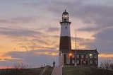
Montauk Point Lighthouse
Encyclopedia
The Montauk Point Light is a lighthouse
located in Montauk Point State Park
at the easternmost point of Long Island
, in the Town of East Hampton
, Suffolk County, New York. The lighthouse was the first to be built within the state of New York
, and is currently the fourth oldest active lighthouse in the United States
.
 Construction on the lighthouse was authorized by the Second United States Congress, under President George Washington
on April 12, 1792. Construction began on June 7, 1796, and was completed on November 5, 1796, the first public works project of the United States of America. Sometime in early April of 1797 keeper Jacob Hand lit the wicks in the lamps in the tower and the lighthouse began operation. The lighthouse was operated by civilian keepers until World War II.
During World War II
, the lighthouse was taken over by the U.S. Army as part of the Eastern Coastal Defense Shield. The last three civilian keepers, Thomas Buckridge, Jack Miller, and George Warrington departed in the spring of 1943. Adjacent to the lighthouse, Camp Hero was opened by the Army in 1942 and was heavily fortified with huge guns during the war. Those gun emplacements and concrete observation bunkers (which are also at nearby Shadmoor State Park
) are still visible. In 1946 the United States Coast Guard
took over maintenance of the lighthouse and operated it until the station was automated on February 3, 1987.
It was the first lighthouse in New York State, and is the fourth-oldest active lighthouse in the United States. The tower is 110' 6" high. The current light, installed in July 2001, equivalent to approximately 290,000 candle power
, flashes every 5 seconds and can be seen a distance of 17 nautical miles (31 km).
Pirate Captain Kidd was said to have buried treasure at the foot of the lighthouse around 1699 at two ponds which today are called "Money Ponds."
In 1860 the lighthouse station underwent a massive renovation when two new levels and a larger lantern were added to the lighthouse, increasing the height of the tower from its original 80 feet (1796) to its current height of 110' 6". A first order Fresnel lens, 12 foot high, 6 feet in diameter, and weighing about 10,000 pounds was installed in the new lantern. At the same time, the current keeper's dwelling was constructed adjacent to the tower. The original 1796 dwelling was then demolished.
A steam-powered fog signal was installed in 1873. A fog signal building was added in 1897.
The tower was originally all white. Its single brown stripe was added in 1899. A fourth order fixed red range light was added to the watchdeck of the tower in 1903 to warn of Shagwong Reef, a navigational hazard about 3 1/2 miles northwest of the lighthouse. It was severely damaged in the hurricane of September 21, 1938 and removed on July 1, 1940 when the lighthouse was electrified.
The huge first order Fresnel lens was replaced in 1903 with a 3 1/2 order bivalve Fresnel lens, which served until February 3, 1987 when it was replaced with an airport beacon with a strength of 2.5 million candela.
The Coast Guard considered tearing down the lighthouse in 1967 and replacing it with a steel tower further from the edge of the bluff. When the tower was built on Turtle Hill it was 300 feet (91.4 m) from the edge of the cliff. It is now 100 feet (30.5 m) away from the edge. After World War II
the United States Army Corps of Engineers
built a seawall at its base, but the erosion continued. In the wake of protests over the announced dismantling of the tower, Congressman Michael Forbes
proposed a bill to the United States Congress to hand over the Lighthouse to the Montauk Historical Society from the Public so it could preserved. The bill was passed. Then, Giorgina Reid (1908–2001), a textile designer who had saved her Rocky Point, New York
cottage from collapse by building a simple set of terraces in the gullies of the bluff, proposed to the Society to do the same at Montauk. It is now 100 feet (30 m) away from the edge. Reid's concept Reed-Trench Terracing called for building the terrace platforms made of various beach debris—notably reeds. The practice (along with further strengthening of the rocks at the bluff toe) has appeared to have stemmed the erosion. She patented the process and wrote an article about it titled How to Hold up a Bank.
Greg Donohue, a Montauk landscaper, worked with Giorgina Reid at the Point and kept the project moving forward after she retired in 1986. With support from various sources, including the Montauk Historical Society, the State of New York, and other agencies, the Erosion Control Project of Montauk Point was successfully completed in 1998. Problems in recent years have again prompted attention to forestall the erosion threat.
It was reported in November 2006 that the United States Army Corps of Engineers
was planning to build a seawall
to solve the continuing erosion
problem. This plan has been opposed by a local surfing
group which contends that a seawall would ruin the nearby world-renowned surf break, and propose moving the lighthouse back from the shore, as was done with the Cape Hatteras Light
house. Complicating such a move is the terrain that would require the lighthouse to be moved down one hill and then up another hill. There are also environmental concerns about whether reducing the erosion at Montauk would increase erosion at other Long Island beach
es. It remains to be seen whether the seawall plans will be affected by these concerns.
The lighthouse was automated on February 3, 1987, and in May of that year the lighthouse museum opened to the public, operated by the Montauk Historical Society, who leased the property from the US Coast Guard for that purpose. On September 30, 1996 President Bill Clinton signed legislation transferring the lighthouse property over to the Montauk Historical Society.
Suffolk Transit's S94 route also serves the lighthouse seasonally connecting it with Montauk Village
.
Lighthouse
A lighthouse is a tower, building, or other type of structure designed to emit light from a system of lamps and lenses or, in older times, from a fire, and used as an aid to navigation for maritime pilots at sea or on inland waterways....
located in Montauk Point State Park
Montauk Point State Park
Montauk Point State Park is located in the hamlet of Montauk, at the eastern tip of Long Island in the Town of East Hampton, Suffolk County, New York. Montauk Point is the easternmost extremity of the South Fork of Long Island, and thus also of New York State...
at the easternmost point of Long Island
Long Island
Long Island is an island located in the southeast part of the U.S. state of New York, just east of Manhattan. Stretching northeast into the Atlantic Ocean, Long Island contains four counties, two of which are boroughs of New York City , and two of which are mainly suburban...
, in the Town of East Hampton
East Hampton (town), New York
The Town of East Hampton is located in southeastern Suffolk County, New York, at the eastern end of the South Shore of Long Island. It is the easternmost town in the state of New York...
, Suffolk County, New York. The lighthouse was the first to be built within the state of New York
New York
New York is a state in the Northeastern region of the United States. It is the nation's third most populous state. New York is bordered by New Jersey and Pennsylvania to the south, and by Connecticut, Massachusetts and Vermont to the east...
, and is currently the fourth oldest active lighthouse in the United States
United States
The United States of America is a federal constitutional republic comprising fifty states and a federal district...
.
History
George Washington
George Washington was the dominant military and political leader of the new United States of America from 1775 to 1799. He led the American victory over Great Britain in the American Revolutionary War as commander-in-chief of the Continental Army from 1775 to 1783, and presided over the writing of...
on April 12, 1792. Construction began on June 7, 1796, and was completed on November 5, 1796, the first public works project of the United States of America. Sometime in early April of 1797 keeper Jacob Hand lit the wicks in the lamps in the tower and the lighthouse began operation. The lighthouse was operated by civilian keepers until World War II.
During World War II
World War II
World War II, or the Second World War , was a global conflict lasting from 1939 to 1945, involving most of the world's nations—including all of the great powers—eventually forming two opposing military alliances: the Allies and the Axis...
, the lighthouse was taken over by the U.S. Army as part of the Eastern Coastal Defense Shield. The last three civilian keepers, Thomas Buckridge, Jack Miller, and George Warrington departed in the spring of 1943. Adjacent to the lighthouse, Camp Hero was opened by the Army in 1942 and was heavily fortified with huge guns during the war. Those gun emplacements and concrete observation bunkers (which are also at nearby Shadmoor State Park
Shadmoor State Park
Shadmoor State Park is a state park located in Suffolk County, New York in the USA. The park is in the East Hampton , New York on the South Fork of Long Island, east of Montauk village....
) are still visible. In 1946 the United States Coast Guard
United States Coast Guard
The United States Coast Guard is a branch of the United States Armed Forces and one of the seven U.S. uniformed services. The Coast Guard is a maritime, military, multi-mission service unique among the military branches for having a maritime law enforcement mission and a federal regulatory agency...
took over maintenance of the lighthouse and operated it until the station was automated on February 3, 1987.
It was the first lighthouse in New York State, and is the fourth-oldest active lighthouse in the United States. The tower is 110' 6" high. The current light, installed in July 2001, equivalent to approximately 290,000 candle power
Candela
The candela is the SI base unit of luminous intensity; that is, power emitted by a light source in a particular direction, weighted by the luminosity function . A common candle emits light with a luminous intensity of roughly one candela...
, flashes every 5 seconds and can be seen a distance of 17 nautical miles (31 km).
Pirate Captain Kidd was said to have buried treasure at the foot of the lighthouse around 1699 at two ponds which today are called "Money Ponds."
In 1860 the lighthouse station underwent a massive renovation when two new levels and a larger lantern were added to the lighthouse, increasing the height of the tower from its original 80 feet (1796) to its current height of 110' 6". A first order Fresnel lens, 12 foot high, 6 feet in diameter, and weighing about 10,000 pounds was installed in the new lantern. At the same time, the current keeper's dwelling was constructed adjacent to the tower. The original 1796 dwelling was then demolished.
A steam-powered fog signal was installed in 1873. A fog signal building was added in 1897.
The tower was originally all white. Its single brown stripe was added in 1899. A fourth order fixed red range light was added to the watchdeck of the tower in 1903 to warn of Shagwong Reef, a navigational hazard about 3 1/2 miles northwest of the lighthouse. It was severely damaged in the hurricane of September 21, 1938 and removed on July 1, 1940 when the lighthouse was electrified.
The huge first order Fresnel lens was replaced in 1903 with a 3 1/2 order bivalve Fresnel lens, which served until February 3, 1987 when it was replaced with an airport beacon with a strength of 2.5 million candela.
The Coast Guard considered tearing down the lighthouse in 1967 and replacing it with a steel tower further from the edge of the bluff. When the tower was built on Turtle Hill it was 300 feet (91.4 m) from the edge of the cliff. It is now 100 feet (30.5 m) away from the edge. After World War II
World War II
World War II, or the Second World War , was a global conflict lasting from 1939 to 1945, involving most of the world's nations—including all of the great powers—eventually forming two opposing military alliances: the Allies and the Axis...
the United States Army Corps of Engineers
United States Army Corps of Engineers
The United States Army Corps of Engineers is a federal agency and a major Army command made up of some 38,000 civilian and military personnel, making it the world's largest public engineering, design and construction management agency...
built a seawall at its base, but the erosion continued. In the wake of protests over the announced dismantling of the tower, Congressman Michael Forbes
Michael Forbes
Michael Patrick Forbes is a politician from the state of New York.- Early life and career:Michael Patrick Forbes was born on 16 July 1952 in Riverhead, New York. Forbes graduated from the SUNY Albany. Forbes worked as an assistant for Republicans U.S. Sen. Al D'Amato and U.S. Rep. Connie Mack...
proposed a bill to the United States Congress to hand over the Lighthouse to the Montauk Historical Society from the Public so it could preserved. The bill was passed. Then, Giorgina Reid (1908–2001), a textile designer who had saved her Rocky Point, New York
Rocky Point, New York
Rocky Point is a hamlet in Suffolk County, New York on the North Shore of Long Island. As of the United States 2000 Census, the CDP population was 10,185.Rocky Point is a community in the town of Brookhaven.-Geography:...
cottage from collapse by building a simple set of terraces in the gullies of the bluff, proposed to the Society to do the same at Montauk. It is now 100 feet (30 m) away from the edge. Reid's concept Reed-Trench Terracing called for building the terrace platforms made of various beach debris—notably reeds. The practice (along with further strengthening of the rocks at the bluff toe) has appeared to have stemmed the erosion. She patented the process and wrote an article about it titled How to Hold up a Bank.
Greg Donohue, a Montauk landscaper, worked with Giorgina Reid at the Point and kept the project moving forward after she retired in 1986. With support from various sources, including the Montauk Historical Society, the State of New York, and other agencies, the Erosion Control Project of Montauk Point was successfully completed in 1998. Problems in recent years have again prompted attention to forestall the erosion threat.
It was reported in November 2006 that the United States Army Corps of Engineers
United States Army Corps of Engineers
The United States Army Corps of Engineers is a federal agency and a major Army command made up of some 38,000 civilian and military personnel, making it the world's largest public engineering, design and construction management agency...
was planning to build a seawall
Seawall
A seawall is a form of coastal defence constructed where the sea, and associated coastal processes, impact directly upon the landforms of the coast. The purpose of a seawall is to protect areas of human habitation, conservation and leisure activities from the action of tides and waves...
to solve the continuing erosion
Erosion
Erosion is when materials are removed from the surface and changed into something else. It only works by hydraulic actions and transport of solids in the natural environment, and leads to the deposition of these materials elsewhere...
problem. This plan has been opposed by a local surfing
Surfing
Surfing' is a surface water sport in which the surfer rides a surfboard on the crest and face of a wave which is carrying the surfer towards the shore...
group which contends that a seawall would ruin the nearby world-renowned surf break, and propose moving the lighthouse back from the shore, as was done with the Cape Hatteras Light
Cape Hatteras Light
Cape Hatteras Light is a lighthouse located on Hatteras Island in the Outer Banks of North Carolina near the community of Buxton, and is part of the Cape Hatteras National Seashore....
house. Complicating such a move is the terrain that would require the lighthouse to be moved down one hill and then up another hill. There are also environmental concerns about whether reducing the erosion at Montauk would increase erosion at other Long Island beach
Beach
A beach is a geological landform along the shoreline of an ocean, sea, lake or river. It usually consists of loose particles which are often composed of rock, such as sand, gravel, shingle, pebbles or cobblestones...
es. It remains to be seen whether the seawall plans will be affected by these concerns.
The lighthouse was automated on February 3, 1987, and in May of that year the lighthouse museum opened to the public, operated by the Montauk Historical Society, who leased the property from the US Coast Guard for that purpose. On September 30, 1996 President Bill Clinton signed legislation transferring the lighthouse property over to the Montauk Historical Society.
Suffolk Transit's S94 route also serves the lighthouse seasonally connecting it with Montauk Village
Montauk, New York
Montauk [ˈmɒntɒk] is a census-designated place that roughly corresponds to the hamlet with the same name located in the town of East Hampton in Suffolk County, New York, United States on the South Shore of Long Island. As of the United States 2000 Census, the CDP population was 3,851 as of 2000...
.
External links
- The Official Montauk Point Lighthouse Web Site
- National Park Service List of New York Lighthouses
- New York State Parks: Montauk Point State Park
Image gallery
Further reading
- "On Eagle's Beak: A History of the Montauk Point Lighthouse" by Henry Osmers. Outskirts Press, 2008.
- "Living on the Edge: Life at the Montauk Point Lighthouse 1930-1945" by Henry Osmers. Outskirts Press, 2009.
- "They Were All Strangers: the Wreck of the John Milton at Montauk, New York" by Henry Osmers. Outskirts Press, 2010.